


Introduction
17
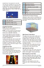
ner’s Eye 3D chart view.
You can set and follow a course to a desti-
nation using one of three methods: Go To,
Route To, or Guide To.
Go To
: Takes you directly to the destination.
This is the standard option for navigating
to a destination. The chartplotter creates
a straight-line course or navigation line
to the destination. The path may run over
land and other obstacles.
Route To
: Creates a route from your location
to a destination, allowing you to add turns
along the way. This option provides a
straight-line course to the destination, but
allows you to add turns into the route to
avoid land and other obstacles.
Guide To
: Creates a path to a destination
using Auto Guidance.
This option is available only when using a
compatible premium chart in a compatible
chartplotter. It provides a turn- by-turn
navigation line to the destination, avoiding
land and other obstacles. The navigation
line is based on the chart data and the
safe depth, safe height, and shoreline dis-
tance user-defined chartplotter settings.
Using these settings and chart data, the
chartplotter creates a navigation line that
avoids all areas that cannot be navigat-
ed between the present location and the
destination.
When you are using a compatible Garmin
autopilot connectedto the chartplotter
usingNMEA 2000
®
,the autopilot follows
the Auto Guidance route.
Basic Navigation Questions
Question
Answer
How do I make the
chartplotter point me in
the direction in which I
want to go (bearing)?
Navigate using
Go To. See
How do I make the
device guide me along a
straight line (minimizing
cross track) to a location
using the shortest dis-
tance from the present
location?
Build a single-leg
route and nav-
igate it using
Route To. See
.
How do I make the
device guide me to a
location while avoiding
charted obstacles?
Build a multi-
leg route and
navigate it using
Route To. See
How do I make the de-
vice steer my automatic
pilot?
Navigate using
Route To. See
Can the device create a
path for me?
If you have
premium maps
that support
Auto Guidance
and are in an
area covered by
Auto Guidance,
navigate using
Auto Guidance.
See
How do I change the
Auto Guidance settings
for my boat?
See
Destinations
You can select destinations using various
charts and 3D chart views or using the lists.
Searching for a Destination by Name
You can search for saved waypoints, saved
routes, saved tracks, and marine services
destinations by name.
1
Select
Navigation Info
>
Search by
Name
.
2
Enter at least a portion of the name of
your destination.
3
If necessary, select
Done
.
The 50 nearest destinations that contain
your search criteria appear.
4
Select the destination.


