AeroNav 900/880 Series Pilot’s Guide
89000039-010
Rev 1 May 2019
Map Subsystem
4-21
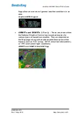
Diagonal stripes show the Datalink radar data no coverage area. In
normal operation the boundary follows the outline of the Continental
United States (CONUS). If, however, Datalink radar is unavailable in
a particular area for any reason, hatched lines appear in that area. In
the mountains and off the coast, hatched lines may represent no
coverage below 10,000 feet. If there are radar returns in that region
above 10,000 feet, the returns will be displayed as “islands of
precipitation” surrounded by the hatched lines.
ADS-
B (“FIS-B”) radar data coverage areas can be very irregular
shaped areas
– the geometry is dependent on how many
transmission sites are in view and how much data has been received
by the on-board receiver.
No Datalink Coverage Area Hatched Lines
Содержание AeroNav 880
Страница 4: ...AeroNav 900 880 Series Pilot s Guide 89000039 010 ii Rev 1 May 2019 Blank Page...
Страница 68: ...AeroNav 900 880 Series Pilot s Guide 89000039 010 1 58 System Overview Rev 1 May 2019 Blank Page...
Страница 94: ...AeroNav 900 880 Series Pilot s Guide 89000039 010 2 26 SVS Subsystem Rev 1 May 2019 Blank Page...
Страница 292: ...AeroNav 900 880 Series Pilot s Guide 89000039 010 5 68 Aux Subsystem Rev 1 May 2019 Blank Page...
Страница 315: ...AeroNav 900 880 Series Pilot s Guide 89000039 010 Rev 1 May 2019 Navigation 6 23...
Страница 383: ...AeroNav 900 880 Series Pilot s Guide 89000039 010 Rev 1 May 2019 General 7 53 Download Logs LSK Confirm Cancel LSKs...
Страница 412: ...AeroNav 900 880 Series Pilot s Guide 89000039 010 7 82 General Rev 1 May 2019 Bluetooth pairing pairing code...


