


10
E N T E R I N G A D E S T I N A T I O N ( 1 / 4 )
The map also provides information on the road
types on the journey (motorways, toll roads, fer-
ries, motorail, etc).
You can change view mode: there is a traffic inci-
dent map view or a traffic incident list view.
Press the “Detour all” button to avoid all areas with
traffic disruption.
Press the “Go” button to start the selected route.
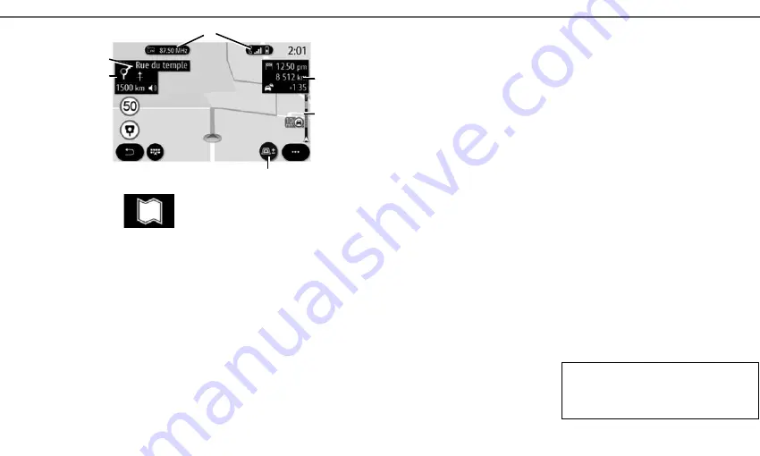
A panel indicates the speed limit that you should
observe. You will be notified when you come to a
control area.
Use the
1
buttons to access shortcuts “Radio” and
“Phone”.
Certain POI (point of interest) provide additional
information such as:
– “Fuel station” also indicates the fuel price associ-
ated to your vehicle;
– The “Charging station” map indicates the number
of vehicle charging sockets available.
Use area
2
to access information on your journey,
such as the arrival time and delay time due to traf-
fic.
Use area
5
to access details on the next changes
in direction and the name of the next road to be
taken
6
.
Use area
3
to access details on the traffic condi-
tions.
You can view information about upcoming turns,
name of next street, arrival time, additional time
due to traffic conditions and distance.
Press the
4
button to display the 2D/2DNorth,
3D/3D Inception views.
“Map”
From the home screen, press “Menu”, then
“Navigation” to access the map.
You can also access the map from the “Navigation”
widget.
The map shows your current position, the current
road name and the information that you configured
(show POIs, weather, traffic display, etc.).
5
6
3
Refer to the system instructions for further in-
formation
4
2
1
Routes des Rédacteurs


