


32
English
positioning the manual cursor on the segment itself.
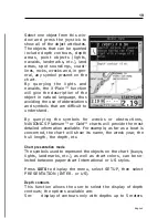
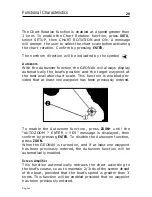
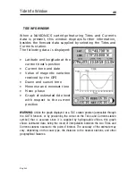
The color of chart items can be chosen from DAY, NIGHT or
BRIGHT. Press
GOTO
to display the menu, select SETUP, MODE
and then DAY, NIGHT or BRIGHT.
Backup copy in the CompactFlash™
To be sure that no data can be accidentally lost, every time
data are saved or the unit is turned off, one copy of route,
track and marker information will be saved on the cartridge.
The file names are the following:
•
For tracks: TRKBCK01 and TRKBCK02
•
For markers: MRKBCK01 and MRKBCK02
•
For routes: RUTBCK01 and RUTBCK02
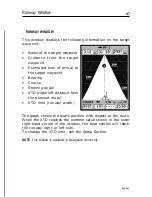
Fishfinder functions
The GEONAV can be connected to a black-box unit, supplied
as an optional device, to become a complete depth sounder
providing fishfinder functions.
The fishfinder employs the Sonar technology to scan the area
below the boat and provide - unlike a standard depth sounder
- a complete range of data, such as the outline and nature of
the seabed, the presence of suspended obstructions, as well
as the type of obstruction (eg., banks of fish).
The black-box unit supplied with the GEONAV sounds the
depth with a 350W power signal at a 170kHz frequency, and
is able to provide highly detailed information.
For further information on the settings and use of the fishfinder
function, see the relevant sections.
Functional Characteristics
Summary of Contents for Geonav 5 Touring
Page 1: ...User and Installation Guide 5Touring...
Page 2: ......


