background image


62 


NAVIGATION 

3.6 Watching the Simulation of the Route 

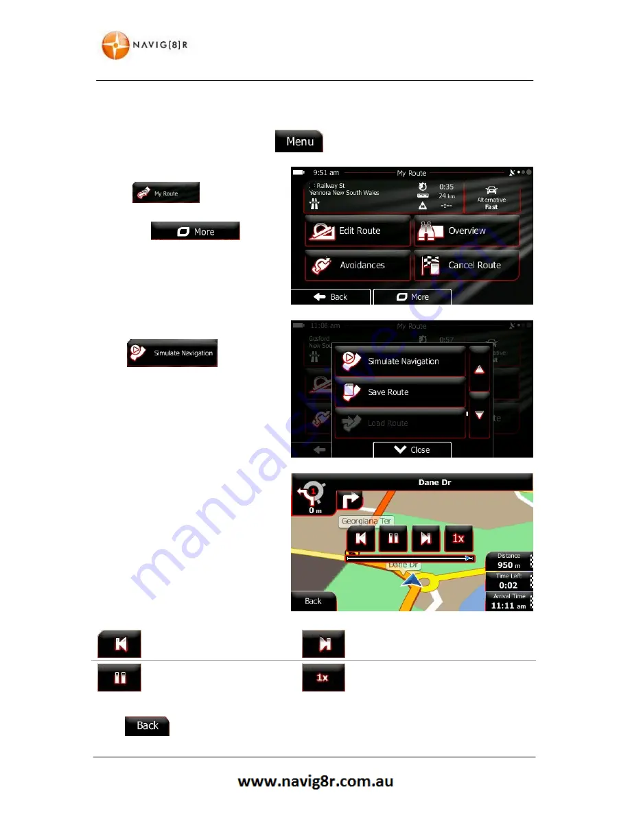
You can run a simulated navigation that demonstrates the active route. Do as follows

1.


If you are on the Map screen, tap  

 to return to the Navigation menu. 

In  the  navigation  menu  tap 


Tap 


2.


Scroll down the list and tap

.  

The simulation starts from the 
starting point of the route, and 
using a realistic speed, it leads you 
through the whole recommended 
route. 


3.


You have the following controls 
during the simulation (the control 
buttons disappear after a few 
seconds but you can open them 
again if you tap the map): 


Jump  to  the  previous  route 
event. 


Jump to the next route event. 


Pause 

or 

restart 

the 

simulation. 


Tap  to  increase  the  speed  of  the 
simulation to4, 8 or 16 times faster. 


Tap 


to stop the simulation at any time

Summary of Contents for GPS unit

Page 1: ...N 9 Before Using the Navig8r Please Read the Following 10 Key Features 10 2 Getting Started With Your Navig8r GPS System 11 2 1 Start Up Screen The Navigation Menu 13 2 2 Buttons and Other Controls on...

Page 2: ...ew Route Waypoint or Final Destination 53 3 4 2 Setting a New Starting Position for the Route 54 3 4 3 Editing the List of Destinations Edit Route 56 3 4 4 Pausing the Active Route 56 3 4 5 Cancelling...

Page 3: ...4 3 9 Regional Settings 83 4 3 10 Trip Monitor Settings 84 4 3 11 Log Collection 84 4 3 12 Start Configuration Wizard 84 4 3 13 Reset to Defaults 84 5 UPDATING 85 6 GLOSSARY 86 2D 3D GPS reception 86...

Page 4: ...ower 91 6 2 4 Sound 92 6 2 5 Time 92 6 2 6 Sound 93 6 2 7 System 93 6 3 Tools 94 6 3 1 Calculator 94 6 3 2 Picture Viewer 94 6 4 GPS Test 95 7 TECHNICAL SPECIFICATIONS 96 T43B 96 T50B 96 8 FREQUENTLY...

Page 5: ...he user s responsibility to follow all local traffic regulations and traffic signs when driving Local conditions and regulations may change at short notice and may not be included in the software mapp...

Page 6: ...ION 1 The Navig8r GPS unit 2 GPS device holder 3 Bracket Windscreen Mount 4 Car Charger 12v DC 5 USB Data Cable 1 Getting To Know Your Navig8r GPS ITEM DESCRIPTION ITEM DESCRIPTION 1 Power Button 2 3...

Page 7: ...n the battery It may take several charge discharge cycles for the device to reach peak endurance The charging process will take longer if the device is turned on Subsequent charging should take less t...

Page 8: ...the suction cup to become loose and should be checked on a regular basis To avoid damage or theft the GPS should not be left on the windscreen mount overnight To remove the mount from the windscreen...

Page 9: ...9 NAVIGATION NAVIGATION...

Page 10: ...accessories can be identified and you can assemble the navig8r GPS Also please read the section on Mounting the GPS unit in your vehicle in the hardware section to ensure that the Navig8r is mounted s...

Page 11: ...h your fingertips However a stylus is supplied When using the navigation software for the first time an initial setup process starts automatically Do as follows 1 Select the written language of the ap...

Page 12: ...e marked TTS 5 If needed modify the time format and unit settings Later you can change them in Regional settings Tap the button to confirm and continue 6 Set the preferred default Route Settings to be...

Page 13: ...rest a location on the map and or select from one of your Favourites Shows the route parameters and the route in its full length on the map You can also perform route related actions such as editing a...

Page 14: ...on Some icons function as buttons Tap to change List Displayed when Several options are available List can be moved by sliding finger tip up and down the screen until the list ends or using the to mov...

Page 15: ...st Correcting your entry on the keyboard Tap to remove the unneeded character s Tap and hold the button to delete several characters or the entire input string Entering a space for example between a f...

Page 16: ...ap and hold any of the and buttons on the Map screen you can rotate tilt or scale the map continuously Tap and hold on keyboard screens you can delete several characters quickly Tap and hold or in lon...

Page 17: ...area When there is no GPS position the Vehimarker is transparent It shows your last known position You see coloured dots circling around a satellite symbol in the top left corner The more green dots...

Page 18: ...r of menu screens Default data fields when navigating a route tap and hold any of the fields to change its value FIELD DESCRIPTION Shows the distance you need to travel on the route before reaching yo...

Page 19: ...how your exact GPS position and heading If roads are near it is aligned to the nearest road to suppress GPS position errors and the direction of the icon is aligned to the direction of the road 2 3 2...

Page 20: ...oad maps show them Their width and colours correspond to their importance you can easily tell a motorway review and Next Street When navigating a route the top section of the Map screen shows informat...

Page 21: ...is no valid GPS position your software uses the last known position as the start point Waypoint intermediate destination An intermediate destination of the route before reaching the final destination...

Page 22: ...examine the map at various zoom levels always with optimised content It always displays street names and other text with the same font size never upside down and you only see the streets and objects t...

Page 23: ...tic map rotation is also re enabled The map manipulation buttons disappear and navigation continues Additional options Tap this button to open a list of additional features like saving the Cursor as a...

Page 24: ...ation if there is no route calculated Find Find Places Quick Search Tap this button to select one of your Favourite destinations Find Favourite Tap this button to select one of your previous destinati...

Page 25: ...map screen and the type of information is displayed More Settings Map settings This function opens the Visual Guidance settings screen More Settings Visual Guidance This function lets you bypass parts...

Page 26: ...ent ways Find Find Places This function opens the Map screen and starts simulating the active route My Route More Simulate Navigation This function opens the GPS Information screen with satellite posi...

Page 27: ...Displays the current Longitude position WGS84 format Altitude elevation information coming from the GPS receiver often inaccurate Displays the current known house number on the right Displays the curr...

Page 28: ...last known position Tap to display the nearest car repair centres Tap to display the nearest Medical and Emergency services Tap to display the nearest police stations Tap to display the nearest fuel...

Page 29: ...e to create a multi point route You can add as many destinations to your route as you like 3 1 Selecting the Destination of A Route The software offers you several ways of choosing your destination En...

Page 30: ...o as follows 1 If you are in the map screen tap to return to the Navigation Menu 2 In the Navigation menu tap and then tap 3 Tap the Country button to select the State your destination is in or to cha...

Page 31: ...urb of your destination Your current location or the last know GPS location is displayed by default b Use the keyboard to enter the name of the suburb or town As above only the available letters are a...

Page 32: ...eet name is always shown in the input field To accept tap to continue Tap to display the results and select from the list Tap at any time to return to the previous screen 2 Enter the house number a Ta...

Page 33: ...tire route The route is automatically calculated Tap to modify the route parameters or tap to start you re your journey TIP If you know that you will use the destination frequently before tapping to c...

Page 34: ...arameters or tap to start your journey 3 1 1 3 Selecting an Intersection as the Destination You can also enter an intersection as the destination 1 Follow steps laid out in Entering an Address and ent...

Page 35: ...e destination or tap to select a new destination 5 After a short summary of the route parameters the map appears showing the entire route The route is automatically calculated 6 Tap to modify the rout...

Page 36: ...guess is correct tap to select it After entering a couple of letters tap to list the items that contain the specified letters You can speed up finding an intersection Search first for the street with...

Page 37: ...arch for a Place by its name In addition you can search for special services from the Where Am I screen 3 1 2 1 Quick Search for a Place of Interest The Quick search feature lets you quickly find a Pl...

Page 38: ...elected Place if included Tap to return to the map 7 If necessary tap the map somewhere else to modify the destination The cursor appears at the new location Tap to confirm the destination or tap to s...

Page 39: ...ched around the current position If the current position is not available either no GPS signal they are searched around the last known position If an active route exists If there is no active route de...

Page 40: ...cluded Tap return to the map 7 If necessary tap the map somewhere else to modify the destination The cursor appears at the new location Tap to confirm the destination or tap to select a new destinatio...

Page 41: ...n of the active route The result list will be ordered by the distance from the destination To search along the active route and not around a given point This is useful when you search for a later stop...

Page 42: ...own position from the selected city town from the destination or by the length of the necessary detour To reorder the list tap the button 10 Browse the list if necessary and tap one of the list items...

Page 43: ...to the previous screen To search around the current position or if it is not available around the last know position The result list will be ordered by the distance from this position To search for a...

Page 44: ...rlier to search in 5 Tap the button to search in all Places or select one of the main place categories e g Accommodation to search in 6 Tap the button to search in the selected Place category or selec...

Page 45: ...necessary and tap one of the list items A full screen map appears with the selected point in the middle The name and address of the Place is displayed at the top of the screen 12 Tap to see the detail...

Page 46: ...current position is not available Tap to display the nearest car repair centres Tap to display the nearest Medical and Emergency services Tap to display the nearest police stations Tap to display the...

Page 47: ...a short summary of the route parameters the map appears showing the entire route The route is automatically calculated 10 Tap to modify the route parameters or tap to start your journey 3 1 3 Selectin...

Page 48: ...n tap If you are in the Navigation menu tap and then tap 2 The list of Favourites will be displayed 3 Tap the Favourite that you want to set as your destination If necessary browse down to see more of...

Page 49: ...tware the better it can guess your desired destination 1 If you are on the Map screen tap to return to the Navigation menu 2 In the Navigation menu tap 3 Tap or destination in the History field 4 A fu...

Page 50: ...ost likely destinations The rest of the destinations are ordered by time they were last selected If necessary scroll the list to see earlier destinations 3 A full screen map appears with the selected...

Page 51: ...3 Tap 4 There is only one line in the list of route points the start point of the route normally the current GPS position 5 Tap to select the destination 6 Destination menu appears and you can select...

Page 52: ...route planning method e g Fast Route on the Map An overview of eth active route can be displayed Map screen tap to return to the Navigation menu In the Navigation menu tap active is displayed in its...

Page 53: ...g from route alternatives changing route parameters simulating the route saving the active route or loading a previously saved route Back Tap to return to the Navigation Menu 3 4 Modifying the Route W...

Page 54: ...end of the route The other destinations of the route remain intact The previous final destination is now the last waypoint 3 4 2 Setting a New Starting Position for the Route For normal navigation all...

Page 55: ...ion menu appears and you can select the start point of the route the same way you select a destination When the new start point is set tap The map returns with a transparent Vehimarker showing that th...

Page 56: ...ave the following options Tap to add a new waypoint in to the route or a new destination Tap to delete the waypoint or destination Tap to modify the starting point of the route Tap to reorder the list...

Page 57: ...and then The active route is cancelled with all its waypoints 3 4 6 Changing the Route Planning Method Route Alternatives To recalculate the active route with a different route planning method you ca...

Page 58: ...he speed this route type is rarely practical for normal vehicles Combines the benefits of Fast and Short The software calculates as if it was calculating the Fast route but it takes other roads as wel...

Page 59: ...en 2 Tap and then select the type of vehicle you are driving Some of the available options are 3 The software recalculates the route optimised for the new vehicle type The orange line now shows the ne...

Page 60: ...for a longer period of time They can be enabled or disabled separately from toll roads The software includes toll roads pay roads where there is a per use charge in the routes by default If you disab...

Page 61: ...ct a destination as described before It can be an address a Place any location on the map a previously used destination from History a coordinate or a location where a photo was taken 2 When the full...

Page 62: ...ion starts from the starting point of the route and using a realistic speed it leads you through the whole recommended route 3 You have the following controls during the simulation the control buttons...

Page 63: ...lour themes during the day and during the night for both the map and the menu screens Daytime colours are similar to paper road maps and the menus are bright The night colour themes use dark colours f...

Page 64: ...se options are indicative only Actual time Manoeuvre restrictions and directional constraints are taken into account when planning a route Roads are used only if access for cars is allowed Private roa...

Page 65: ...re excluded from routes Manoeuvre restrictions and directional constraints are taken into account when planning a route Roads are used only if access for Truck Private roads resident only roads and wa...

Page 66: ...tically recalculates the route if you deviate from the proposed itinerary or if a newly received Traffic event concerns a part of the recommended route 4 1 5 Road Safety Cameras and Other Proximity Al...

Page 67: ...our region ask your local dealer or may not be fully correct for all roads in the map Speed warning can be fine tuned in Sound and Warning settings page 72 You can set the relative speed above which t...

Page 68: ...onnected On such devices the icon does not appear in normal circumstances The software is connected to the GPS receiver but the signal is too weak and the receiver cannot determine the GPS position GP...

Page 69: ...ze units for men s or women s cloth types and shoes The scientific calculator helps you in all your calculation needs Tap the Mode button for additional functions and use the memory to save your resul...

Page 70: ...icense Agreement look up content licenses or check the unique identifier of the software You can also access program usage statistics 4 3 Settings Menu You can configure the program settings and modif...

Page 71: ...rrow to a 3D car model show or suppress 3D buildings turn track logging on or off and manage you Place visibility sets which Places to show on the map Settings related to guidance on the map screen ca...

Page 72: ...o cycle through the options Verbose Minimal Compact Maps may contain information about the speed limits of the road segments The software is able to warn you if you exceed the current limit This infor...

Page 73: ...erent if you are below or above the given speed limit Only when speeding The audio alert is only played when you exceed the given speed limit When approaching The audio alert is always played In order...

Page 74: ...ts key sounds Controls for each sound type Button Description Volume Slider Adjusts the volume of the related sound or Use the switch to mute the related sound The slider becomes inactive Tap again to...

Page 75: ...s and track logs More Trip Monitor Displays information about current location N A Create or Edit a route My Route Create Route This function opens the list of manoeuvres the itinerary Tap the top of...

Page 76: ...ton Description You can set the type of vehicle you will use to navigate the route Based upon this setting some of the road types can be excluded from the route or some of the restrictions may not be...

Page 77: ...ts are taken into account when planning a route Roads are used only if access for pedestrians is allowed Controlled access roads are excluded from routes A private road is used only if the destination...

Page 78: ...s Manoeuvre restrictions and directional constraints are taken into account when planning a route Roads are used only if access for Truck Private roads resident only roads and walkways are excluded fr...

Page 79: ...ets The times and projected CO2 emissions displayed using these options are indicative only Actual time and emissions will vary 4 3 5 Vehicle Profile You can enter the vehicle information to allow the...

Page 80: ...es only and can vary between actual results Please ensure that the variables such as petrol price economy etc are correct at the time of route calculation Please check Route Alternatives to get the be...

Page 81: ...tilt levels to your needs Three levels are available Low Normal High Automatic Overview when navigating will display the overview of the route to be taken if there are no driver instructions to be fo...

Page 82: ...lds in the corner of the Map screen can be customised Tap this button and select the values you want to see The values can be different when you navigate a route from when you are just cruising withou...

Page 83: ...your local language measurement units time and date settings and formats as well as to choose the time zone Button Description This button displays the current written language of the user interface...

Page 84: ...p 4 3 11 Log Collection The navigation Software collects information on how the application is used This information can be used for improving the application These logs are processed anonymously and...

Page 85: ...e is not MAC compatible Registration of the Navig8r must be completed on the Naviextras webpage http www naviextras com 1 After logging on to the website click on the link to create a user profile and...

Page 86: ...of the settlement but an arbitrary point the map creators have chosen In towns and villages it is usually the most important intersection in larger cities it is one of the important intersections Col...

Page 87: ...figure the software to warn you when you approach one of these cameras Detecting the location of Road Safety Cameras is prohibited in certain countries It is the sole responsibility of the driver to c...

Page 88: ...88 HARDWARE Hardware...

Page 89: ...tion or even recalibrating the touch screen Tapping on each will access different sub menus and features Note Prior to launching any features that may access the Micro SD card reader please ensure tha...

Page 90: ...EM Description Tap on any screen to return to the Main System Screen Enters the system language settings Enters the system backlight settings Shows title of current menu Enters the system power settin...

Page 91: ...System screen Gives and indication of the current charge level Use the button to select a time to for GPS to automatically sleep after last screen tap Tap the button to return to the previous screen...

Page 92: ...d region information will be saved as soon as this menu is exited Tap the button to return to the previous screen or the button to return to the Main System screen NOTE The times settings made in this...

Page 93: ...ication Application version number Kernel Version Kernel version number SN Serial Number Device Serial number SDRAM Total SDRAM Displays total System Ram Usable SDRAM Displays usable system ram FLASH...

Page 94: ...iew the image Display previous image Display next image Zoom In Zoom out Rotate image 90 clockwise rt Slideshow tap screen to end Display image in original size Display in full screen tap screen to ex...

Page 95: ...mation about the number of satellites detected and the quality of the signal Tap the GPS Reset button to reset the GPS antenna if reception difficulties are noticed Tap the button to return to the pre...

Page 96: ...ansion Slot SDHC Micro SD SDHC Micro SD Speaker Inbuilt speaker Inbuilt speaker USB USB 2 0 USB 2 0 Hot Start 3 seconds 3 seconds Warm Start 29 seconds 29 seconds Cold Start 38 seconds 38 seconds GPS...

Page 97: ...st 6 of these satellites GPS satellites transmit signals constantly These signals are aimed at earth based receivers such as GPS navigation systems Each satellite transmits data about its location and...

Page 98: ...accurate to within 15 meters The GPS system is only as accurate as the mapping software in the unit If the map data is incorrect the visual representation of you location may not be displayed correct...

Page 99: ...ss Storage devices simular to USB drives Macs running OSX 10 2 or later should be able to access the GPS and SD Card Slot by connecting with the supplied USB cable without the need for any software or...

Page 100: ...ion without having to turn your head or take your eyes of the road while driving Q I find it hard to enter an address while driving what should I do A The driver of a vehicle should not attempt to ent...

Page 101: ...ng A CBD areas can have a canyon affect on GPS systems Not only can tall buildings hide the signal from GPS satellites it can also reflect the signals of the satellites that can be detected This makes...

Page 102: ...uct by those persons having unlawfully acquired the software product or having unlawfully installed it on a computer or in a vehicle 3 Relevant laws and regulations 3 1 To all issues not regulated by...

Page 103: ...of this Agreement 6 Rights of the User 6 1 The User is entitled to install the Software Product into one hardware device desktop handheld portable computer navigation device and to run and use one cop...

Page 104: ...blic in any format or to download them from the product 8 No warranty or limitation of responsibility 8 1 The Licensor hereby informs the User that although the greatest care was taken in producing th...

Page 105: ...ars in prison in basic cases and up to eight years in prison in aggravated cases 9 3 Contents and services provided by third parties The Licensor hereby excludes any liability of its own for the Datab...

Page 106: ...ent 10 COPYRIGHT NOTE The product and the information contained herein is subject to change without prior notification This manual may not in whole or in part be reproduced or transmitted in any form...

Reviews: