Magellan NAV 6500/NAV 6510
78
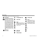
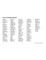
Natural Features (ICE)
Ice area; Pingo.
Natural Features (RIVERS)
Canal; Canal bank; Rapids;
River; River bank; Waterfall.
Navigational aid, generic
Navigational mark fixed
Navigational mark floating
Offshore Installation
Cable, submarine; Cable area;
Diffuser; Obstruction; Off-
shore production area; Pipe-
line, submarine/on land;
Pipeline area; Production in-
stallation.
Marine farm/culture
Mast
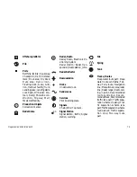
Meta objects
Accuracy of data; Compilation
scale of data; Horizontal datum
of data; Nautical publication
information; Production infor-
mation; Sounding datum of
data; Survey reliability; Survey
source; Units of measurement
of data; Vertical datum of data.
Mooring/Warping facility
Monument
Natural Features
Coastline; Dune; Hill; Lake
shore; Land area; Land eleva-
tion; Land region; Salt Pan;
Slope Topline; Tree; Vegetation
area.
Flare stack
Fish haven
Fishing facility
Fog signal
Fortified structure
Lake
Landmarks
Tower.
Light
Light vessels
Light House
m
Summary of Contents for NAV 6500
Page 1: ...NAV 6500 NAV 6510 User Manual M A G E L L A N...
Page 3: ...Magellan NAV 6500 NAV 6510 User Manual...
Page 8: ...Coordinate Systems 93 What Is GPS 95 Explanation of Data Terms 97 Glossary 99 Index 102...
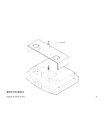
Page 81: ...Magellan NAV 6500 NAV 6510 73 Flush Mount Diagram...
Page 112: ...Magellan NAV 6500 NAV 6510 104...
Page 113: ......
Page 114: ...630323 960 Overland Court San Dimas CA 91773 USA 909 394 5000...


