background image

87

Trip Calculator, Time, Sonar and Miscellaneous Data. You can select
items from any of these categories for display in any data box. The
category divisions are only there to help you sort through the
information.

To change information displayed in a data box:

On the page with the digital data box you wish to change, press

MENU

|

 to 

C

USTOMIZE

|

ENT

. A data box name flashes, indicating it is

selected. Press 

ENT

 to modify the box or hit 

 or 

 to select another box,

then press 

ENT

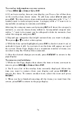
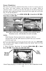
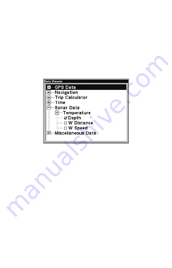
. You'll see a list of categories with "+" or "–" symbols

next to each category. A category with a "+" is 

expandable

, meaning its

contents are hidden.

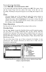
Data Viewer with the Sonar Data category expanded.

Selecting the category name and pressing 

ENT

 will show the category's

contents, so you can choose items within it. An expanded category (one
with a "–" next to its name) can be collapsed to hide its contents. Just
select the category name and press 

ENT

.

Expand any categories that might contain data you want to display.
Then press 

 or 

 to select a different data option. With the new option

highlighted, press 

ENT 

to switch the contents of the box to the new data

type, then press 

EXIT

. You can now select another box to change. When

you are finished with the settings, press 

EXIT

 again and the box name

stops flashing.

NOTE

A Page display can only show a limited number of data boxes.

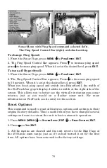
FlashGraf

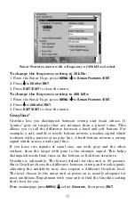
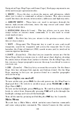
The FlashGraf sonar page option represents a flasher style sonar
combined with a scrolling chart. A circular dial shows all returning
echoes at a high screen refresh rate. It uses the Grayline


feature to

Summary of Contents for LCX-17M

Page 1: ...le as a simulator download from this CD or from the Lowrance web site To download from the CD select download follow the prompts and it will be added to your Start and All programs list LCX 17M Fish f...

Page 2: ...4 Shoot thru hull preparation 24 Shoot thru hull Installation 27 Speed Temperature Sensors 29 GPS Antenna Receiver Module 30 Power Connections 33 NMEA 2000 Cable Connections 36 Connecting to a NMEA 20...

Page 3: ...a 75 Ping Speed HyperScroll 78 Reset Options 79 Reset Water Distance 80 Set Keel Offset 80 Sensitivity Auto Sensitivity 81 Sonar Chart Mode 83 Sonar Page Sonar Chart Display Options 83 Full Sonar Char...

Page 4: ...g a Trail 121 Displaying a Saved Trail 122 Navigating Trails 123 Visual Trailing 123 Navigate a Trail forward 123 Navigate a Back Trail backtrack or reverse 126 Transfer Custom Maps and GPS Data Files...

Page 5: ...etup Options 141 Alarms 141 Auto Satellite Search 142 Check MMC Files and Storage Space 142 Communications Port Configuration 143 Configure NMEA 143 Coordinate System Selection 144 Map Fix 145 Customi...

Page 6: ...l Options 165 Delete All Trails 165 Update Trail Option 165 Delete Trail 166 New Trail 167 Trail Visible Invisible and Other Trail Options 167 Units of Measure 167 Section 9 Searching 169 Find Address...

Page 7: ...phabetical order Before you turn on the unit it s a good idea to learn about the different keys the Main Menu the four Page screens and how they all work together BUT if you just can t wait to get on...

Page 8: ...search for waypoints and access the waypoint list It also launches the Point of Interest POI search menus and is involved in some navigation functions 8 ZOUT Zoom Out This key lets you zoom the scree...

Page 9: ...the menu screen and return to the page display press EXIT Remember our text style for MENU MENU means press the Menu key twice See a full explanation of our instruction text formatting on page 11 Ins...

Page 10: ...ew the installed MMC card and the files it contains Pages The unit has four Page displays that represent the four major operating modes They are the Satellite Status Page the Navigation Page the Map P...

Page 11: ...e Status Page Navigation Page This screen has a compass rose that not only shows your direction of travel but also the direction to a recalled waypoint To get to the Navigation Page Press PAGES or to...

Page 12: ...a GPS function so it is discussed in much greater detail in Sec 6 Sonar Page The Sonar Page displays the sonar chart This is a cross section view of the water column beneath the boat The chart moves...

Page 13: ...onar chart display option commands left Sonar Page in full sonar chart display mode right Sonar chart display options from left split zoom and split frequency Sonar chart display options from left dig...

Page 14: ...ll of those features and options in Sec 4 but to show you how easy the unit is to operate the following page contains a simplified 10 step quick reference that will cover most fish finding situations...

Page 15: ...n of the screen The full sonar chart will scroll from right to left showing you what s under the boat as you cruise across the water You can change the display by Zoom in to enlarge the chart for more...

Page 16: ...tions when too much clutter appears on the screen Decreasing the sensitivity can reduce the clutter and show the strongest fish echoes if fish are present As you change the sensitivity setting you can...

Page 17: ...ithout cruise control you have complete manual control of the car s speed In this unit manual mode allows you to set sensitivity at 100 percent maximum or zero percent minimum Depending on water condi...

Page 18: ...but it can be fooled Some of the echoes calculated to be fish could be tree limbs or turtles To see what s under your boat in maximum detail we recommend you turn off Fish I D and begin learning to in...

Page 19: ...Multimedia Player with forward reverse pause fast forward fast reverse and scroll buttons Adjustments update the entire record displayed Window can dynamically be sized on your monitor Mouse cursor s...

Page 20: ...actly like your real sonar GPS unit Using the Sonar Simulator and GPS Simulator features it allows you to play back sonar logs run GPS routes and trails even create real waypoints you can use in the f...

Page 21: ...In all cases noise can produce unwanted marks on the display The ASP feature has four settings Off Low Medium and High If you have high noise levels try using the High ASP setting However if you are...

Page 22: ...the deep alarm s setting For example if you set the shallow alarm to 10 feet the alarm will sound a tone if the bottom signal is less than 10 feet It will continue to sound until the bottom goes deep...

Page 23: ...ABLED ENT EXIT EXIT EXIT 5 To turn off the alarm press MENU MENU to ALARMS ENT to SONAR ALARMS ENT to DEEP ALARM ENABLED ENT EXIT EXIT EXIT To switch to a different depth setting open the Sonar Alarms...

Page 24: ...or other suspended objects are detected by the Fish I D feature Fish I D must be turned on for the Fish Alarm to work A different tone sounds for each fish symbol size shown on the display Sonar Alar...

Page 25: ...number and repeat until the percentage is correct then press EXIT Chart Speed The rate echoes scroll across the screen is called the chart speed The default is maximum We recommend you leave the sett...

Page 26: ...ted left Sonar chart with the depth cursor active right The line indicates the large fish is 21 95 feet deep The cursor can be moved to any location on the screen letting you pinpoint the depth of a t...

Page 27: ...2 Press to DEPTH RANGE ENT and the Depth Range Control Scale appears 3 Press or to select a different depth range A horizontal black bar highlights the selected range 4 When the new range is selected...

Page 28: ...LIMITS ENT The Sonar Chart Limits menu appears with Upper Limit selected 2 To set the upper limit press ENT Press or to change the first number then press to move the cursor to the next number and rep...

Page 29: ...l echoes and eliminates surface clutter thermoclines and other undesirable signals In most instances remaining targets are fish The Fish I D feature displays fish symbols on the screen in place of the...

Page 30: ...ing information This and other features can help you successfully see beneath the boat under varied water and fishing conditions Practice with Fish I D mode on and off to become more familiar with it...

Page 31: ...nly when the Fish I D feature is on The default setting for FishTrack is off To turn on FishTrack Note These instructions will turn on FishTrack and Fish I D at the same time 1 From the Sonar Page pre...

Page 32: ...80 percent of the fresh and salt water sport fishing applications When you get into very deep salt water 300 to 500 feet or deeper the 50 kHz frequency is the best choice The 200 kHz transducer will...

Page 33: ...ft muddy or weedy bottom returns a weaker signal which is shown with a narrow or no gray line A hard bottom returns a strong signal which causes a wide gray line If you have two signals of equal size...

Page 34: ...the sonar data shown on the screen can be saved to it This can be played back at any time To play a recorded sonar chart log see the entry in this section for Sonar Simulator If you have a personal c...

Page 35: ...ou ve changed the settings select START LOGGING Noise Rejection See the entry on Advanced Signal Processing in this section Overlay Data On any page display except the Satellite Status and Navigation...

Page 36: ...ght contain data you want to display Then press or to select a data option 4 With the data option highlighted press ENT to check it turn it on or uncheck it turn it off As you turn it on the data will...

Page 37: ...satisfied press EXIT EXIT NOTE The Customize command and the Overlay Data command use the same information categories The difference between the two commands is the Customize command is only used to m...

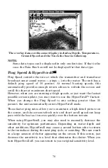
Page 38: ...een update you may want to use the HyperScroll feature When you change the Ping Speed to any setting greater than 50 percent the unit automatically enters HyperScroll mode These faster ping rates allo...

Page 39: ...the width of the FasTrack bar graph display doubles in width at the right side of the screen This allows you to better see the virtually instantaneous sonar returns just as you would on a flasher son...

Page 40: ...transducer Since the transducer is installed below the water surface the depth displayed by the digital depth chart depth scale chart cursor or fish symbols is not exact If the transducer is 1 foot be...

Page 41: ...from the face of the transducer to the surface the water line on the boat In this example we will use 1 5 feet This will be entered as a positive 1 5 feet which makes the depth indicators perform as i...

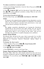
Page 42: ...control bar used to adjust sensitivity up or down is the same whether the unit is in the automatic or manual mode In automatic you can adjust sensitivity up to 100 percent but the unit will limit you...

Page 43: ...l Bar on the screen as the chart scrolls You can see the changes on the screen as you press the up or down arrows This is handy when there s a lot of clutter in the water and you are matching the sens...

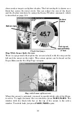
Page 44: ...creen represents the surface The bottom depth and surface temperature if equipped with a temperature sensor or a transducer with a temp sensor built in show at the top left corner of the screen The Fa...

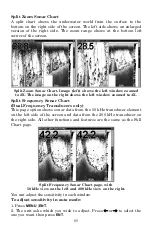
Page 45: ...o 4X Split Frequency Sonar Chart Dual Frequency Transducers only This page option shows sonar data from the 50 kHz transducer element on the left side of the screen and data from the 200 kHz transduce...

Page 46: ...each window Digital Data Chart This mode shows the chart on the right side of the screen The left side has four digital boxes containing Depth Track Bearing and a Temperature Graph Digital Data Chart...

Page 47: ...category name and pressing ENT will show the category s contents so you can choose items within it An expanded category one with a next to its name can be collapsed to hide its contents Just select th...

Page 48: ...its the screen in half with the map on the left and the sonar on the right This screen option can be found on the Pages Menu under the Map Page category Map with Sonar split screen When this screen is...

Page 49: ...n Menu with Sonar Setup command selected left Sonar Simulator menu with simulator turned on right NOTE With Simulate Position checked the simulator will also automatically run the GPS simulator if GPS...

Page 50: ...g to another by opening the Sonar Simulator menu and using the instructions in step 2 to select a different chart NOTE If you turn on your unit before attaching a transducer it may enter a demo mode T...

Page 51: ...gnals from the display It does this by changing the sensitivity of the receiver decreasing it near the surface and gradually increasing it as the depth increases There are three levels of surface clar...

Page 52: ...N once doubles the size 2X of all echoes on the screen Pressing it again quadruples the size of the echoes 4X The zoom bar on the far right side of the screen shows which echoes will be displayed on t...

Page 53: ...re lets you rapidly move the zoomed area up and down to different depths By pointing your zoom at different portions of the chart as it scrolls you can get a good close up look at structure or cover b...

Page 54: ...94 Notes...

Page 55: ...mode make sure that either the transducer or the antenna is securely connected before turning the unit on Unit freezes locks up or operates erratically 1 Electrical noise from the boat s motor trolli...

Page 56: ...The technical term for this is cavitation 2 Electrical noise from the boat s motor can interfere with the sonar This causes the sonar to automatically increase its Discrimination or noise rejection f...

Page 57: ...ansducer cable away from the wiring that is causing the interference VHF radio antenna cables radiate noise when transmitting so be certain to keep the sonar s wires away from it You may need to route...

Page 58: ...98 Notes...

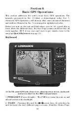
Page 59: ...s a good idea to learn about the different keys the four Page screens and how they all work together BUT if you just can t wait to get outside turn to the one page Quick Reference on page 111 Keyboar...

Page 60: ...igation functions 8 ZOUT Zoom Out This key lets you zoom the screen out On the Sonar Page this key returns you to a full sonar chart display showing the entire water column from surface to bottom On t...

Page 61: ...sables the sounds for key strokes and alarms and sets the alarm style Alarms command turns GPS or sonar alarms on or off and changes alarm thresholds Route Planning command used to plan view or naviga...

Page 62: ...scrolls across the screen from right to left displaying signal echoes that represent fish structure and the bottom The Sonar Page is discussed in detail in Sec 3 To get to the Sonar Page Press the PAG...

Page 63: ...ceiver is tracking satellites represented by a black bar The receiver hasn t locked onto a satellite if the number is a lighter shade therefore it isn t being used to solve the position Beneath the ci...

Page 64: ...llowing a route or trail Your position is shown by an arrow in the center of the screen Your trail history or path you ve just taken is depicted by the line extending from the arrow The arrow pointing...

Page 65: ...ty made good It s the speed that you re making toward the waypoint For instructions see the Customize Page Displays entry in Sec 8 Track is the heading or the current direction you are actually travel...

Page 66: ...ptions Options and setup are discussed in Sec 8 To access the Navigation Page Menu from the Navigation Page press MENU Map Page The Map Page screens show your course and track from a bird s eye view B...

Page 67: ...e with a few Point of Interest icons visible left Numerous Points of Interest dots become visible at the 3 mile range along with minor streets center At the 0 6 mile zoom you can see an interstate hig...

Page 68: ...As you zoom in closer the symbols become readable icons In the 0 6 mile zoom example right the cursor has selected the Cupps Caf POI which triggers a pop up box with the POI name This pop up box work...

Page 69: ...perate on A black title bar denotes the active window Resize Window is another handy feature for pages that have two major windows You can change the horizontal size of the windows to suit your viewin...

Page 70: ...can also use the Reset Options command to revert to the factory default Map Menu with Resize Window command selected left Pressing moves the centerline and enlarges the left window right The followin...

Page 71: ...the map by Zoom in closer to see greater detail press ZIN zoom in key Zoom out to see more area less detail press ZOUT zoom out key Scroll map north south east or west using arrow keys To stop scroll...

Page 72: ...key zoom in to move in closer and see greater detail in a smaller geographic area 2 Press the ZOUT key zoom out to move farther away and see less map detail but a larger geographic area When you are...

Page 73: ...ple we ll look for the nearest fast food restaurant For more information on different types of searches refer to Sec 9 Searching NOTE This example requires the Point of Interest POI database included...

Page 74: ...lighted But we just want to see it on the map so press to FIND ON MAP ENT POI information screen on the nearest fast food restaurant showing name street address phone number latitude longitude distanc...

Page 75: ...d used later for navigational purposes You can create a waypoint at the cursor position on the map or at your current position while you are navigating You can create a waypoint at any location by man...

Page 76: ...int Symbol is described in Sec 7 After you have changed a waypoint symbol the unit will remember the one you chose and use it the next time you quick save a waypoint To revert back to the default symb...

Page 77: ...t any waypoint visible on the Map Page with the cursor then use the Navigate to Cursor command which will be covered later in this section You can avoid scrolling the map to pick your waypoint if you...

Page 78: ...e time Your position at the time these keys are pressed is used as the man overboard position Caution Saving a new Man Overboard waypoint will erase the previous Man Overboard waypoint Navigate Back t...

Page 79: ...To Cursor command navigates to the current cursor position on the map It s a quick and handy way to navigate to anything you can see on the map display 1 Use the cursor controlled by the arrow keys w...

Page 80: ...tion to your destination The 30 mile zoom right shows current position and direction to destination on screen To stop navigating to the cursor use the Cancel Navigation command press MENU MENU to CANC...

Page 81: ...efault is 2 000 but it can record trails up to 9 999 points long When the point limit is reached the unit begins recording the trail over itself By default the trail flashes once a second making it ea...

Page 82: ...ve and recall up to 10 different plot trails which can be copied to your MMC for archiving or for transfer to your MapCreate software Tip Another quick way to stop recording one trail and begin a new...

Page 83: ...ling however provides no navigation information during the trip such as the time to your destination The other two methods provide a full range of navigation data and work with both the Map Page and N...

Page 84: ...m will go off as soon as you hit Enter Just press EXIT to clear the alarm and proceed 5 Now begin moving and follow your unit 6 When you reach your destination be sure to cancel your navigation press...

Page 85: ...views at left driver is northbound heading straight toward trail point 6 bearing arrow shows the trail point is due north straight ahead At right driver has reached trail point 6 and must turn west t...

Page 86: ...ning a Custom Map File is loaded into the unit it automatically loads the map into memory when the unit is turned on Instructions for copying Custom Map Files to an MMC are contained in the instructio...

Page 87: ...ansfer data from the MMC to the unit press to LOAD ENT 3 Saving to MMC To accept the default name Data for the GPS Data File press to SAVE DATA ENT If you wish to rename the file as shown in the follo...

Page 88: ...lay a completion message when the data transfer is finished To return to the Page view press EXIT EXIT EXIT These figures show the menu sequence for loading a GPS Data File from an MMC into the unit s...

Page 89: ...ce between two other points on the map 1 While on the Map Page press MENU to FIND DISTANCE ENT 2 Center your cursor over the first position A rubber band line appears connecting your current position...

Page 90: ...t Icon Symbol menu 3 Press or or or to select your icon symbol then press ENT The icon appears on the map Select Icon Symbol menu left Boat Ramp icon on map right Cursor has been moved for clarity Cre...

Page 91: ...elected icon location press MENU ENT Follow course line on the Map Page or the compass bearing arrow on the Navigation Page Routes A route is a series of waypoints linked together in an ordered sequen...

Page 92: ...and insert the MMC in the unit See Sec 2 for instructions on installing MMCs To load the GPS Data File into the Unit memory see the entry on Transfer Custom Maps GPS Data Files in Sec 6 Basic GPS Oper...

Page 93: ...1 Set route waypoint 1 at 11th St 145th Ave Fig 2 Move cursor north to set point 2 at 145th Admiral Fig 3 With point 2 set move cursor east to mark interstate on ramp with waypoint 3 In figures 2 and...

Page 94: ...ENT 3 Press to NAVIGATE then to DELETE ENT to YES ENT Tip You can also delete all routes at once 1 From the NAVIGATION PAGE WITH DIGITAL DATA press MENU ENT or from the MAP PAGE press MENU MENU to RO...

Page 95: ...the route View Waypoint will show you where the selected waypoint is on the map Navigate a Route 1 From the NAVIGATION PAGE press MENU ENT or from the MAP PAGE press MENU MENU to ROUTE PLANNING ENT R...

Page 96: ...ich is 2 36 miles away Fig 4 shows route navigation on the Map Page In this figure the traveler has reached Wpt 4 and is half way along the leg between Wpts 4 and 5 Navigate a Route in Reverse Here s...

Page 97: ...all up the Edit Trail menu by selecting a trail on the map with the cursor Simply move the cursor over a trail and a pop up box appears Press WPT and the Edit Trail menu opens Trail selected with map...

Page 98: ...tor To get to the Sun Moon menu press MENU MENU to SUN MOON CALCULATIONS ENT Trip Calculator To get to the Calculator menu press MENU MENU to TRIP CALCULATOR ENT Trip Down Timer To get to the Down Tim...

Page 99: ...EXIT EXIT EXIT EXIT Waypoint Position To edit waypoint position 1 Press WPT ENT ENT ENT to waypoint name ENT to EDIT WAYPOINT ENT 2 Latitude press to LATITUDE ENT Press or to change the first charact...

Page 100: ...t or a location from the Points of Interest list 1 Press WPT to SUBCATEGORY column to NEW ENT 2 Press to PROJECTED POSITION ENT to CREATE ENT 3 Press to CHOOSE REFERENCE ENT Use and to select a waypoi...

Page 101: ...o 0 1 mile then the alarm flashes a message if you drift 0 1 of a mile or more to the right or left of the line to the waypoint The anchor alarm is triggered when you drift outside of a preset radius...

Page 102: ...ceiver is turned on for the first time it doesn t know what your position or elevation altitude is It does know the current UTC time and date since these were programmed into it at the factory and an...

Page 103: ...device such as an autopilot Com port 1 and Com port 2 can be used for NMEA Menus for changing Com Port settings For assistance in configuring the unit to communicate with another device consult the fa...

Page 104: ...6 14952 degrees minutes and thousandths of a minute 36 28 700 or degrees minutes seconds and tenths of a second 36 28 40 9 It can also show position in UTM Universal Transverse Mercator projection MGR...

Page 105: ...es Do this by selecting Setup Loran TD at the bottom of the Coordinate System menu and select the ID Press EXIT to close this menu Configure Loran TD menu Map Fix Map Fix is used with charts or maps T...

Page 106: ...pears and MAP SCALE is highlighted Press ENT and enter the map s scale This is generally at the bottom of the paper map It s shown as a ratio for example 1 24000 Press EXIT and the unit returns to the...

Page 107: ...ll see a list of categories with or symbols next to each category A category with a is expandable meaning its contents are hidden Customize Menu with the GPS Data category expanded Selecting the categ...

Page 108: ...R ON box and pressing ENT key Press EXIT EXIT EXIT to close this menu A message and tone appear periodically warning you that the simulator is on To turn the simulator off repeat the above steps or tu...

Page 109: ...ith this command The default setting is off allowing you to rotate between the Sonar Page and the GPS pages and features To hide GPS features Press MENU MENU to SYSTEM SETUP ENT to HIDE GPS FEATURES E...

Page 110: ...ss MENU to AUTO ZOOM ENT EXIT Repeat these steps to turn it off Map Data This menu lets you turn the map off if desired which turns the map screen into a GPS plotter turn on or off the pop up map info...

Page 111: ...miles in diameter same as the zoom range The second smaller ring is 50 miles in diameter always 1 2 the zoom range The distance from your current position to the smaller ring the ring s radius is 25 m...

Page 112: ...st page displayed press EXIT EXIT A list of the datums used by this unit is in the back of this manual GPS Setup Menu left Map Datum Menu right Map Detail Category Selection This menu determines which...

Page 113: ...ection the map doesn t line up with your view of the world To correct this problem a track up mode rotates the map as you turn Thus what you see on the left side of the screen should always be to your...

Page 114: ...Navionics chart at 11 15 mile zoom center and with a 5 56 mile zoom right To display a Navionics chart 1 Install the Navionics MMC in the memory card compartment and turn on the unit For full card in...

Page 115: ...icons on the map display An example is displayed in the following figure To view Port Services information 1 Use the arrow keys to move the cursor over a Port Services icon When selected a pop up nam...

Page 116: ...s ENT Port Services information screens Tidal Current Information Navionics charts contain Tidal Current information represented at large zoom ranges by a box icon with the letter C The icon stands fo...

Page 117: ...ion at the present time The graph at the top of the example above is an approximate view of the flood and ebb pattern from midnight MN to noon NN to midnight MN The velocity scale at the top left side...

Page 118: ...ently small zoom range the icon itself becomes an animated gauge showing a rising or falling tidal height for the selected station At larger zoom ranges you can select the boxed T icon and it becomes...
Page 119: ...data for other dates by changing the month day and year selection boxes To select another date 1 Use and to highlight month day or year then press ENT 2 Use and to select the desired month day or year...

Page 120: ...to RESET OPTIONS ENT to YES ENT NOTE Reset Options does not erase any waypoints routes icons plot trails or sonar logs Reset Options command left and the Reset Options Menu right Screen Contrast and...

Page 121: ...the screen s display mode Press to DISPLAY MODE ENT press or to select mode EXIT Display Mode menu Set Language This unit s menus are available in 10 languages English French German Spanish Italian Da...

Page 122: ...to select the month then press ENT To set the Day Press to DAY ENT Press or to select the day then press ENT To set the Year Press to YEAR ENT Press or to select the year then press ENT You also may s...

Page 123: ...press EXIT EXIT to return to the page display 3 You can return to this command and press ENT again to turn the feature on Software Version Information From time to time Lowrance updates the operating...

Page 124: ...splay To set Alarm Volume Press to VOLUME Press or to move the bar The left end of the scale is low volume the right end is high volume After the option is set press EXIT EXIT to return to the page di...

Page 125: ...to MY TRAILS ENT My Trails command left Trails Menu left Trail Options right Delete All Trails To remove all of the trails from memory from the Trails Menu press to DELETE ALL ENT to YES ENT Update Tr...

Page 126: ...date Distance data entry box appears on the menu Trail Update Rate Time Distance You can update a trail by time with a range from 1 second to 9999 seconds the default is 3 seconds You can update by di...

Page 127: ...The Active setting determines whether or not the unit is recording new points for a particular trail On the Edit Trail menu press or to highlight the section you wish to change then press ENT Make you...

Page 128: ...or to change the heading type then press ENT After the option is set press EXIT EXIT EXIT to return to the page display To set Depth Press to DEPTH Press or to change the heading type then press ENT...

Page 129: ...ch functions all begin with either the Find Waypoint menu or the Map Page menu Press WPT and the Find Waypoint menu appears for waypoints and Points of Interest POI From the Map Page press MENU and th...

Page 130: ...reet name you selected is now in the street field Find Address menu left Find Street menu center with Find By Name field active street name entry complete right 5 To enter a city name press to CITY EN...

Page 131: ...rect address from the list then press ENT The Map Page will appear with the location selected by the cursor In the example below we are looking for 12303 East 11th Street in Tulsa not 11th Court so we...

Page 132: ...POI information window then navigate to it right Find Any Item Selected by Map Cursor On the Map Page with a POI or map feature selected by the cursor press WPT To return to the previous page press EX...

Page 133: ...x Press or to change the first letter then press to move the cursor to the next letter and repeat until the name is correct then press ENT ENT B Or jump down to the lower selection list by pressing EN...

Page 134: ...u have two choices A Press ENT to navigate or go to the exit B Press ENT to find the exit on the map Go To Exit option left Find On Map option right Tip You can also look up some additional informatio...

Reviews: