Geophysical Survey Systems, Inc.
UtilityScan with GS Software
Manual
MN71-307 Rev B
38
Appendix H: Export to KMZ Function
KMZ files contain the location and attribute information for your collected data. These files can be
opened in Google Earth, which will display the collection path and the location of any target picks or user
marks applied while collecting or playing back the data. The KMZ file format will also store attribute
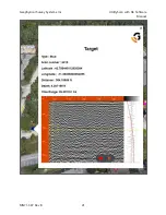
information for each target pick and user mark, which is accessible by clicking on the target icons when
opened in Google Earth:
For user marks, the KMZ will record:
•
Scan number
•
Latitude
•
Longitude
•
Distance along the collection profile
•
A screenshot of the linescan data where the user mark was applied
For target picks, the KMZ will record:
•
Type (color)
•
Scan number
•
Latitude
•
Longitude
•
Distance along the collection profile
•
Depth
•
Time Range
•
A screenshot of the linescan data where the target pick was applied
Creating a KMZ File
If the “Export to KMZ” setting is toggled on in the Project menu prior to collecting data, a KMZ will be
automatically created for each file collected when you press the red stop icon to stop data collection. Note
that the KMZ file will only contain location information if you are collecting data with GPS on.
If the “Export to KMZ” setting is toggled on in the Project menu prior to playing back data, a KMZ will
be automatically created for the portion of the file that was displayed up to the point of pressing the red
stop icon to stop data scrolling. Note that the KMZ file will only contain location information if your data
was collected with GPS on.
Summary of Contents for UtilityScan 50350HS
Page 1: ...MN27 151 Rev A MN71 307 Rev B ...
Page 4: ...Geophysical Survey Systems Inc UtilityScan with GS Software Manual ...
Page 6: ...Geophysical Survey Systems Inc UtilityScan with GS Software Manual ...
Page 8: ...Geophysical Survey Systems Inc UtilityScan with GS Software Manual MN71 307 Rev B 2 ...
Page 14: ...Geophysical Survey Systems Inc UtilityScan with GS Software Manual MN71 307 Rev B 8 ...
Page 20: ...Geophysical Survey Systems Inc UtilityScan with GS Software Manual MN71 307 Rev B 14 1 2 3 4 ...
Page 46: ...Geophysical Survey Systems Inc UtilityScan with GS Software Manual MN71 307 Rev B 40 ...
Page 47: ...Geophysical Survey Systems Inc UtilityScan with GS Software Manual MN71 307 Rev B 41 ...

