Geophysical Survey Systems, Inc.
UtilityScan with GS Software
Manual
MN71-307 Rev B
15
Set Depth ( ):
This feature is used to calibrate your dielectric value and vertical depth scale when you
have a target of a known depth. This is also known as “ground truthing” and can result in very accurate
depth calculations in homogenous ground conditions. You must first collect data crossing the object of
known depth. Then back the system up or move it forward so the vertical cursor scrolls horizontally
through your data until it is bisecting the target of a known depth. Drag the crosshairs down until they are
centered on the target. Press the icon and adjust the depth scale until the horizontal bar intersects it at
the correct depth value of the target. The dielectric value will automatically adjust as the depth scale is
changed.
3D Grid Collection
(
):
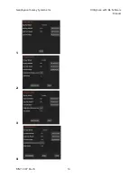
The 3D Grid Collection icon will only be visible when you pause the data
preview in collect mode. Selecting the 3D icon will display the 3D collection module. Here you will enter
your 3D collection parameters, including grid dimensions, line spacing, and collection direction. The 3D
grid image will tell you where to begin collection and what line you are collecting.
Once the antenna is centered over the starting coordinate press the red record button. This initiates data
collection of Line 1. Data will start collecting when the survey wheel starts moving in a forward direction
(or whichever direction was used during SW calibration), and you will see the line progress across the
screen. After traveling the distance that you specified in 3D Setup, the system will automatically stop
collecting data. The file will save and the system will automatically increment to the next line.
•
The X spacing can be different from the Y spacing, but the spacing must be regular.
•
You cannot start your grid at change your line spacing interval part way through the grid to a
different interval.
•
If you need to recollect a line, use the previous line and next line buttons (
/
)to navigate to
the correct line to recollect.
•
Use the View icon (
) to toggle between different views during 3D collection.
•
You can view your grid in Playback mode after it has been collected. For more information on
viewing a 3D grid in Playback mode, see “Playing Back Data” section below.
Set Dielectric (
):
This feature allows you to
calibrate the dielectric value and depth scale using
hyperbola fitting. Hyperbola fitting measures the
geometry of visible hyperbolas in the data to generate
an estimated dielectric constant using a process called
migration. Different dielectric values cause different
dispersion angles, which impact the width of
hyperbolas displayed in data. Using hyperbola fitting to
measure the shape of a hyperbola in your data allows
the GS Software to back calculate velocity of the radar
energy and the resulting dielectric value. Having an
accurate dielectric value also results in a calibrated
depth scale and more accurate depth read-outs.
To use Set Dielectric, align your vertical cursor so it bisects a hyperbola in your data and pull the
horizontal cursor down to the apex of the hyperbola. Tap the Set Dielectric icon, which will cause a
yellow hyperbola to appear at the intersection of the vertical and horizontal cursor. Use your finger to
drag the depth scale up and down to change the width of the yellow hyperbola until it fits perfectly around
the hyperbola in the data. Press the Set Dielectric icon again to save the resulting dielectric value and
close the hyperbola fitting tool.
Summary of Contents for UtilityScan 50350HS
Page 1: ...MN27 151 Rev A MN71 307 Rev B ...
Page 4: ...Geophysical Survey Systems Inc UtilityScan with GS Software Manual ...
Page 6: ...Geophysical Survey Systems Inc UtilityScan with GS Software Manual ...
Page 8: ...Geophysical Survey Systems Inc UtilityScan with GS Software Manual MN71 307 Rev B 2 ...
Page 14: ...Geophysical Survey Systems Inc UtilityScan with GS Software Manual MN71 307 Rev B 8 ...
Page 20: ...Geophysical Survey Systems Inc UtilityScan with GS Software Manual MN71 307 Rev B 14 1 2 3 4 ...
Page 46: ...Geophysical Survey Systems Inc UtilityScan with GS Software Manual MN71 307 Rev B 40 ...
Page 47: ...Geophysical Survey Systems Inc UtilityScan with GS Software Manual MN71 307 Rev B 41 ...

