33
G500/G600 Cockpit Reference Guide
190-00601-03 Rev H
MAP GROUP
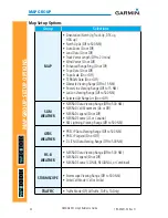
MAP GROUP:
SETUP OPTIONS
Group
Selections
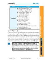
AVIATION
• SafeTaxi Viewing Range (Off to 2.5 NM)
• RWY Extension Range (Off to 2.5 NM)
• INT/NDB Viewing Range (Off to 15 NM)
• VOR Viewing Range (Off to 150 NM)
• Class B/TMA (Off to 500 NM)
• Class C/TCA (Off to 150 NM
)
• Class D (Off to 150 NM
)
• Restricted (Off to 150 NM
)
• MOA (Military) (Off to 150 NM
)
• Other/Adiz (Off to 150 NM
)
• TFR (Off to 500 NM)
• Airways (Off, All, LO Only, HI Only)
• Smart Airspace (On or Off)
• Show Airspaces (All, Below 18000ft - Below 3000ft)
• Airspace Labels (On or Off)
• VRP Viewing Range (Off to 500 NM)
SafeTaxi
®
(Optional)
SafeTaxi is an enhanced feature that gives greater map detail when zooming in
on airports at close range. The airport display on the map reveals taxiways with
identifying letters/numbers and airport landmarks including ramps, buildings,
control towers, and other prominent features. Resolution is greater at lower map
ranges. When the aircraft location is within the screen boundary, including within
SafeTaxi ranges, an airplane symbol is shown on the navigation map views for
enhanced positional awareness. This database is updated on a
56-day cycle
.
NOTE:
Do not use SafeTaxi or ChartView functions as a basis for
ground maneuvering. SafeTaxi and ChartView functions have not
been qualified to be used as an Airport Moving Map Display (AMMD).
SafeTaxi and ChartView are intended to improve pilot situational
awareness during ground operations and should only be used by the
flight crew to orient themselves on the airport surface.
Summary of Contents for G500
Page 1: ...G500 G600 Cockpit Reference Guide...
Page 103: ......


