background image

Page 72 

10.15


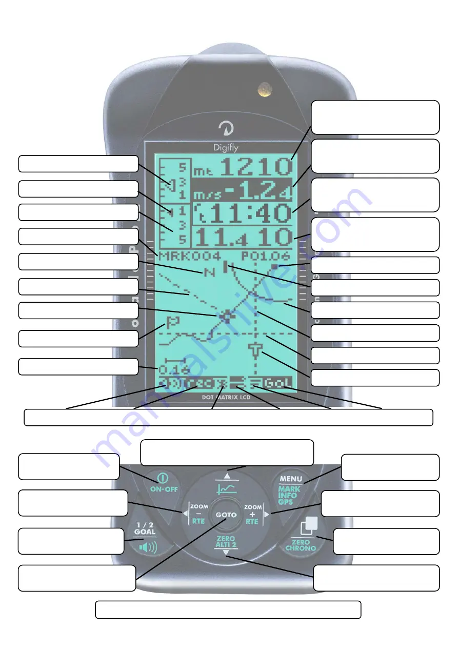
GLIDE PLOTTER DISPLAY SCREEN 


Volume Level - Flight Recorder - Bluetooth Link - Battery State - GPS Signal - Subpage


Last Thermal Direction


Wind Direction


Equivalent McCready


Analogue Vario


Scroll Subpage 


 Volume Off/Med/High


 Go To Waypoint 


  Skip to next start gate


Scroll data field / Zoom- 


 Jump to prev. WP


On/Off GPS antenna 


 On/Off  Instrument


 Info / Edit display data field 


 Graphic Altimeter / Thermal Centering


MENU 


GPS Info/Mark WP


Scroll data field / Zoom+ 


Jump to next WP


Scroll Page 


 Zero Chronograph


Info / Edit display data field 


  Zero A2 Altimeter


  = 

Normal key pressure         


  = 

Long key pressure (2 seconds)


Altimeter A1 
(customisable data field)


Current WP name 


Clock UTC 
(customisable data field)


Efficiency - Ground speed 
(customisable data field)


HSI Bearing to curr.  WP 


FAI Cylinder


Course Predictor


North Direction


McCready


HSI Height over curr. WP


Current WP Direction


Integrated Vario 
(customisable data field)


Next WP Direction


Plotter scale  10pix/km


Pilot Location


Summary of Contents for Cartesio plus

Page 1: ...C a r t e s i o plus C a r t e s i o Pro BT L e o n a r d o Pro L e o n a r d o Pro BT Version 1 3 UK 18 9 2008 User manual ...

Page 2: ...from the date of purchase The Digifly guarantee applies provided the product is handled properly for its intended use in accordance with its operating instructions and upon presentation of the original invoice or cash receipt indicating the date of purchase the dealer s name the model and the serial number of the instrument The customer is however responsible for any transportation costs The unit ...

Page 3: ...6 MENU NAVIGATION 11 2 7 SETTING UP YOUR INSTRUMENT 11 2 8 MULTI LANGUAGE HELP 12 2 9 RESTORE FACTORY SETTINGS 12 3 QUICK REFERENCE GUIDES 13 3 1 THERMAL DISPLAY SCREEN 13 3 2 GLIDE COMPASS DISPLAY SCREEN 14 3 3 GLIDE PLOTTER DISPLAY SCREEN 15 4 DISPLAY 16 4 1 MAIN DISPLAY SCREENS 16 4 2 AUTOMATIC SCREEN SWITCHING INTELLIFLIGHT 16 4 3 GLIDE PLOTTER AND GLIDE COMPASS DISPLAY SCREENS 17 4 3 1 PLOT S...

Page 4: ...2 2 VARIO REACTIVITY 26 5 2 3 ANALOGUE VARIO 26 5 2 4 INTEGRATED AVERAGED VARIO 27 5 2 5 ACOUSTIC VARIO 27 5 2 6 VARIO SIMULATOR 27 5 3 AIR SPEED WITH OPTIONAL AIR SPEED PROBE 28 5 3 1 STALL ALARM 28 5 3 2 AIR SPEED RECALIBRATION 28 5 4 TEMPERATURE 29 5 5 BAROMETER 29 5 6 TIME CHRONOGRAPH 30 5 7 PILOT NAME GLIDER DATA 30 6 ADVANCED FUNCTIONS 31 6 1 TOTAL ENERGY COMPENSATION 31 6 2 THERMAL CENTERIN...

Page 5: ... TO WAYPOINTS 41 7 15 REQUIRED EFFICIENCY TO THE CURRENT NEXT WAYPOINT AND TO ARRIVAL AT GOAL 42 7 16 DIRECTION TO CURRENT AND NEXT WAYPOINT 42 7 17 SAFE LANDING GLIDE CONE INDICATION 42 7 18 WAYPOINT MANAGEMENT 43 7 18 1 MANUALLY CREATE A NEW WAYPOINT 43 7 18 2 CREATE NEW WAYPOINT WITH CURRENT POSITION MARK 44 7 18 3 EDIT WAYPOINT 44 7 18 4 DELETE WAYPOINT 44 7 18 5 NAVIGATE TO A WAYPOINT GOTO 45...

Page 6: ... 5 FLIGHT PLAYBACK 55 9 PC CONNECTION AND INTERFACE 56 9 1 COMPETITION SOFTWARE COMPATIBILITY 56 9 2 CONNECTING WITH COMPEGPS MAXPUNKTE GPSDUMP CHECKIN PWC SOFTWARE 56 9 2 1 UPLOADING COMPETITION WAYPOINTS 56 9 2 2 DOWNLOAD A SINGLE FLIGHT 57 9 2 3 DOWNLOAD ALL FLIGHTS 57 9 3 CONNECTING WITH THE DIGIFLY VLTOOLS SOFTWARE 57 9 4 FIRMWARE UPGRADE 58 9 4 1 UPGRADE PROCESS 59 9 5 PROBLEMS CONNECTING TO...

Page 7: ...TIONS 65 10 7 GPS FUNCTIONS 65 10 8 GENERAL SPECIFICATIONS 65 10 9 MAIN SETUP PARAMETERS 67 10 10 ADVANCED SETUP ADV SETUP PARAMETERS 68 10 11 RESTORE FACTORY SETTINGS 68 10 12 DATA FIELDS SHOWN IN SEQUENCE 69 10 13 THERMAL DISPLAY SCREEN 70 10 14 GLIDE COMPASS DISPLAY SCREEN 71 10 15 GLIDE PLOTTER DISPLAY SCREEN 72 ...

Page 8: ... in the removable battery slot and can also be replaced with other 1 5 volt AA size batteries To change this battery you will need a flat blade screwdriver to unscrew the battery cover on the rear of the vario Rechargeable batteries can be used though are not recommended for the backup battery system because of their high self discharge rate after 2 months they are completely discharged and useles...

Page 9: ...RNAL LITHIUM BATTERY PRO MODELS With the instrument turned off insert the Digifly Wall Adapter Recharger plug in to the left socket of your Digifly flight instrument The vario display shows the blinking message CHARGE while charging and LITIO FULL when fully charged The time required for a full recharge is about 3 hours There is no problem if you leave the vario charging for more than 3 hours as t...

Page 10: ...ess the key at least for 4 seconds After switching off your Digifly instrument you must wait at least 5 seconds before you can turn it on again This prevents unwanted operation e g during transit in your glider bag After turning your Digifly instrument on the first screen briefly shows the vario model pilot name if set vario serial number software version date and time and battery voltage 2 5 DISP...

Page 11: ...T To setup your Digifly instrument and adjust the parameters mentioned in the following sections go to the MENU page by pressing the key function men There are two setup menus on the Digifly instrument The MAIN SETUP menu and the ADVANCED SETUP menu Using the arrow keys scroll to select the MAIN SETUP or the ADVANCED SETUP menu and to select confirm press the key function ENT You will now see a li...

Page 12: ...nge the help language go to MAIN SETUP n 32 LANG select the language of choice When updating the software on the Digifly instrument make sure you upload the latest help file for the language you have selected using the upload HELP function of the Digifly Vltools software on your PC 2 9 RESTORE FACTORY SETTINGS To restore the factory settings default values for all parameters press and hold down th...

Page 13: ... Scroll data field Zoom Jump to prev WP On Off GPS antenna On Off Instrument Info Edit display data field Graphic Altimeter Thermal Centering MENU GPS Info Mark WP Scroll data field Zoom Jump to next WP Scroll Page Zero Chronograph Info Edit display data field Zero A2 Altimeter Normal key pressure Long key pressure 2 seconds Graphic Altimeter Thermal Centering Altimeter A2 customisable data field ...

Page 14: ...raphic Altimeter Thermal Centering MENU GPS Info Mark WP Scroll data field Zoom Jump to next WP Scroll Page Zero Chronograph Info Edit display data field Zero A2 Altimeter Normal key pressure Long key pressure 2 seconds Altimeter A1 customisable data field Current WP name Estim Time to Next WP customisable data field Efficiency Ground speed customisable data field Required Effic to Next WP Distanc...

Page 15: ...aphic Altimeter Thermal Centering MENU GPS Info Mark WP Scroll data field Zoom Jump to next WP Scroll Page Zero Chronograph Info Edit display data field Zero A2 Altimeter Normal key pressure Long key pressure 2 seconds Altimeter A1 customisable data field Current WP name Clock UTC customisable data field Efficiency Ground speed customisable data field HSI Bearing to curr WP FAI Cylinder Course Pre...

Page 16: ...n the Thermal Display screen and Glide Compass Display or Glide Plotter Display screens To enable this function go to ADVANCED SETUP n 1 IFLY and set it to ON The Digifly instrument will switch automatically to the Thermal Display screen when the conditions of a thermal are met To set the thermal detection parameters go to ADVANCED SETUP n 2 THEV and ADVANCED SETUP n 3 THET to adjust the vertical ...

Page 17: ...iency information ground speed wind speed and wind direction For some of these function to be active Waypoints must have been entered in to the Digifly instrument and a Route activated and a GPS FIX achieved 4 3 1 PLOT SCALE To zoom in or out of the live plot of your flight press the arrow keys The plot scale is shown on the left of the screen according to the following values Valore ZOOM Km scher...

Page 18: ...age press the key Sub page 1 is preset with all information related to the WP1 the current Waypoint and is easily recognized by the icon 1 on the display status bar Sub page 2 is preset with all information related to the WP2 the next Waypoint and is easily recognized by the icon 2 2 on the display status bar Sub page 3 is preset with all information related to the arrival Waypoint GOAL and is eas...

Page 19: ...ish to adjust As you scroll up or down the fields that you can customize are highlighted inverted and for approximately 3 seconds a description of the data currently being displayed is shown To change the data you wish to display press the keys Each time a new parameter is selected the field shows the a description of the data currently selected 4 6 DISPLAYING ADDITIONAL INFORMATION RELATING TO WA...

Page 20: ...e field briefly shows a description of the data type currently selected 4 7 TIME INFORMATIONS The Digifly instrument can display time information related to Waypoints and Routes ero Estimated relative time related to start gate time in seconds negative advance wrong positive delay correct es Remaining time to start pylon gate open e1 Estimated remaining time to current Waypoint e2 Estimated remain...

Page 21: ...CIENCY INFORMATIONS efrT Efficiency required to last thermal efr1 Required efficiency to current Waypoint efr2 Required efficiency to next Waypoint efrA Required efficiency Goal effA Instant efficiency related to the Air 4 10 TRACKING AND BEARING INFORMATION The Digifly instrument can display tracking information related to Waypoints and Routes BRT Bearing to last thermal BR1 Bearing to current Wa...

Page 22: ...E TO DESTINATION dstT DIST TO LST TH dst1 DIST TO WPT dst2 DIST TO NEXT dstA DIST TO GOAL EFFICIENCY REQUIRED TO DEST efrT EF REQ TO TER efr1 EF REQ TO WPT efr2 EF REQ TO NXT efrA EF REQ TO GOL SPECIAL INSTRUMENTS effA IST AIR EFF brt BRG TO LST TH br1 BEARING TO WP br2 BEARITO NEXT trk TRACKING TIME TO DESTINATION ero REL TIME STAR eS TIME TO START e1 TIME TO WPT e2 TIME TO NEXT eA TIME TO GOAL C...

Page 23: ...ss the key A confirming message ON GPS is shown and a confirmation of YES or NO is required To synchronize the A1 altimeter barometric altimeter press the key long press this takes you to the MARK page where the current GPS information is also shown You can then check if the GPS altitude is available and stable for at least one minute and at least 5 satellites shown SAT 5 then press the key long p...

Page 24: ...d The A2 altimeter is for generic use To zero the A2 altimeter press the key long press The A3 altimeter is automatically zeroed when a thermal is found There are 2 parameters that can be adjusted to allow the Digifly instrument to identify a thermal the vertical speed vario and for how many consecutive seconds this vertical speed is detected To set the thermal detection parameters go to ADVANCED ...

Page 25: ...nd select which altimeter A1 or A2 you want to adjust Press the key long press A confirmation of YES or NO is required 5 1 4 GRAPHIC ALTIMETER DISPLAY This is a live plot of your altitude against time highlighted here in red it scrolls whilst you are flying It will help you to see how effectively you are climbing or turning in a thermal It is especially useful in weak conditions The scales on the ...

Page 26: ...R The default setting is 0 4 sec To increase the reactivity of the vario reduce the value of this parameter For a more damped response increase this value 5 2 3 ANALOGUE VARIO The long data field highlighted here in red on the left of the Thermal Display page shows the analogue vario value The analogue vario is an instantaneous vario reading This information is shown on the analogue display on the...

Page 27: ...esents the instantaneous values of the vario with a modulated tone The volume of the tone is adjustable over three levels HIGH OFF LOW by pressing the key long pressure The volume level selected is shown by a change in the speaker graphic at the bottom of the screen You can set the threshold level for the Digifly instrument to indicate lift go to MAIN SETUP n 2 V UP and sink go to MAIN SETUP n 3 V...

Page 28: ...d To change the data fields with AIR SPEED press the keys to highlight select the data field you wish to adjust then press the key to select the data field AIR SPEED 5 3 1 STALL ALARM To utilize the stall alarm function you must have an air speed probe connected The optional air speed probe should be plugged in to the right hand socket on the bottom of the vario To enable the stall alarm select MA...

Page 29: ...ield briefly shows a description of the data type currently selected It is possible to adjust the temperature calibration go to MAIN SETUP n 31 KTMP 5 5 BAROMETER The pressure can be shown by the Digifly instrument The pressure data can be shown in any of customizable display fields e g on the Thermal Display screen highlighted here in red To show the pressure data in any of these customizable fie...

Page 30: ...ata currently being shown is that field is shown for approx 3 seconds To change the data you wish to display press the key Each time the data field is changed the field briefly shows a description of the data type currently selected To zero the chronograph press the key long press The vario time and date are automatically synchronized with the GPS at start up Adjust the time zone difference for yo...

Page 31: ...be should be plugged in to the right hand socket on the bottom of the vario To determine the correct total energy compensation value with an air speed probe connected you should fly in calm air conditions and slow down as if you are entering a thermal If the vario shows a change in lift you have to increase the total energy compensation value go to MAIN SETUP n 10 TEC Then try again until the chan...

Page 32: ... up or down the fields that you can customize are highlighted inverted and a description of the data currently being shown is that field is shown for approx 3 seconds To change the data you wish to display press the keys Each time the data field is changed the field briefly shows a description of the data type currently selected 6 4 POLAR DATA To utilize the polar data functions you must have an a...

Page 33: ...polars preloaded 2 for hang gliders and 1 for a paraglider To see the three default polar curves and to calculate your own use the Digifly Excel software available from the Digifly web site www digifly com We suggest that you insert your own polar curve data which best reflects the actual performance of your glider 6 5 SPEED TO FLY To utilize the speed to fly functions you must have an air speed p...

Page 34: ... the correct Speed to fly you have to adjust your speed so both McCready arrows are in the same position 6 6 McCREADY To utilize the McCready functions you must have an air speed probe connected The optional air speed probe should be plugged in to the right hand socket on the bottom of the vario If this parameter ADVANCED SETUP n 8 POLA is set to OFF all display information relating to McCready Mc...

Page 35: ... value indicated from the Equivalent McCready To set the average of the Equivalent McCready go to ADVANCED SETUP n 18 MCRE 6 8 NETTO VARIO To utilize the netto vario function you must have an air speed probe connected The optional air speed probe should be plugged in to the right hand socket on the bottom of the vario If this parameter ADVANCED SETUP n 8 POLA is set to OFF the netto display vario ...

Page 36: ...y The thermal sniffer is an innovative function that helps you to detect a thermal early It alerts you with a sound and the popup message THERMAL when you are in a thermal but your vario is still indicating sink because your sink rate is higher than the speed of the rising air This function uses two parameters the thermal strength and the time over which the thermal must occur To set the thermal d...

Page 37: ...reception 3 bars good GPS reception 2 GPS icon blinking GPS signal not obtained the current GPS position is not provided 3 GPS icon off GPS disconnected or very poor signal 4 GPS icon with a cross GPS antenna is turned off 7 3 POWER SAVING MODES Leonardo Models The GPS receiver in the Digifly Leonardo has 3 power saving modes Go to ADVANCED SETUP n 7 POWE STD The GPS is activated every 1 second wi...

Page 38: ... 15 hours or even less 7 5 GPS INFORMATION DISPLAY To view the GPS information display press the key long press On this page you can read in real time Waypoint name and symbol Latitude Longitude GPS Direction TRK Ground Speed GS in km h GPS Altitude GPS ALT in mt Satellite Number SAT and the strength of the GPS Signal hdp and Battery Voltage VBAT 7 6 LATITUDE LONGITUDE COORDINATES Latitude and Lon...

Page 39: ...rage efficiency value is very important because is the value used by the glide computer 7 11 WIND SPEED AND DIRECTION INDICATION USING GPS The wind speed and direction are automatically calculated and displayed using GPS information of the GPS Direction TRK and the GPS ground speed Gs values To determine the wind speed and direction you should make a normal turn that is neither too tight nor too w...

Page 40: ... is not activated if the current waypoint is the Start Pilon For optimal navigation the cross hair has to be at the same point of your current position icon 7 13 LAST THERMAL INFORMATIONS WITH GPS Indicates the direction brt distance dstT required efficiency ertT and gain altitude A3 to the last thermal To set the thermal detection parameters go to ADVANCED SETUP n 2 THEV and ADVANCED SETUP n 3 TH...

Page 41: ...EIGHT TO WAYPOINTS This is a powerful feature that displays the direction distance and the estimated height of arrival over the current Waypoint H1 next Waypoint H2 and the Arrival Waypoint HA To view this data a Route has to be activated ...

Page 42: ...me in seconds over which the Glide Ratio is averaged go ADVANCED SETUP n 5 EFFA 7 15 REQUIRED EFFICIENCY TO THE CURRENT NEXT WAYPOINT AND TO ARRIVAL AT GOAL This is the estimated efficiency glide ratio or L D required to arrive to the Waypoint and is calculated only if navigation to a Waypoint or Route has been activated This information is shown by the efr1 efr2 efrA data values on the 3 main dis...

Page 43: ...d User Waypoints can be used only in User Routes Rt 2 User Rt 12 User Waypoints can be managed manually through the Digifly instrument or with an external Windows program running on a PC 7 18 1 MANUALLY CREATE A NEW WAYPOINT To create a new Waypoint move the cursor to the first line of the Waypoint list the empty line using the arrow keys then press the key function EDIT the Waypoint Data WPT DATA...

Page 44: ...til the cursor is on the desired Waypoint Press the key function EDIT the Waypoint Data screen then appears with these fields to be completed Name max 6 characters Sym there are 6 graphic symbols icons available to choose from Lat Lon Longitude and Latitude Each Waypoint can be individually edited with its own coordinate System Degrees Minutes and Seconds dd mm ss s Degrees and Minutes dd mm mmm o...

Page 45: ...p to 12 Routes with 20 Waypoints on each Route A Route allows you to automatically navigate to all Waypoints stored in it The Route display includes also the total distance of the route and the total required efficiency for the Route The first Route shown is the Rt 1 Comp Competition Route To scroll through view the other routes Rt 2 User to Rt 12 User use the keys At the bottom of the Route scree...

Page 46: ...function SAVE 7 19 3 INSERT A WAYPOINT IN A ROUTE WITH WAYPOINTS Scroll to the desired position using the arrow keys and then press the key function EDIT From the drop down menu select the INSERT option with the keys and confirm with YES The first Waypoint in the Waypoint list appears scroll through the Waypoint list using the arrow keys and then press the key function SAVE 7 19 4 CHANGE WAYPOINTS...

Page 47: ... arrow keys then press the key function EDIT From the drop down menu select the CLEAR function with the keys and confirm with YES 7 19 6 ACTIVATE DEACTIVATE REVERSE CLEAR A ROUTE To activate a Route press the key and confirm with YES To deactivate a Route press the key and confirm with YES To reverse a Route press the key long press To clear a Route press the key long press and confirm with YES ...

Page 48: ... and COMPEGPS Air 7 20 1 SETUP THE COMPETITION ROUTE Rt 1 Comp Insert in the Competition Route Rt 1 Comp the Waypoints required for the current task Each Waypoint with its own name icon and radius adjustable to 60 000 mt Each Waypoint in the Competition Route has more icon choices than the Waypoints available to the User Routes Waypoints may also include numbers and letters so it will possible for...

Page 49: ...start pylon validation entering into the circle start pylon validation exiting from the circle The Start pylon function is only activated if one of these two start pylon icons is selected If a Waypoint is selected as the Start Pylon it will be shown on the Glide Plotter screen plotter with the S symbol ...

Page 50: ...re ready to navigate 7 20 2 START PYLON NAVIGATION If the current Waypoint is a Start Pylon the message START PILON appears on the glide pages 5 minutes before the Start Pylon Absolute Time Gate the instrument will automatically switch the time display the fifth in the Thermal Display page and the third in the Glide Compass and Glide Plotter Display screen to the Remaining count down timer to Star...

Page 51: ...cross the Start Pylon circle earlier than the Start time gate has opened the distance indicator in the circle dis1 is reversed to alert you that you are on the wrong side When your distance on the wrong side of the Start Pylon becomes greater than 500mt a popup message Wrong Side appears When you are at the start Plyon on an active Route you can jump to the next start time gate if available by pre...

Page 52: ...t recorder rate returns to the setup value MAIN SETUP n 24 RECR The cylinder radius can be adjusted in the Competition Route Rt 1 Comp Scroll to the desired Waypoint using the arrow keys Press the key to select the cylinder radius column Press the key function EDIT and increase or decrease the cylinder radius with the arrow keys To save your changes with the press the key 7 20 4 CHANGE WAYPOINT IC...

Page 53: ...C START RECORD MODE The default record mode is automatic start record mode AUT parameter MAIN SETUP n 22 RECM In the automatic start record mode it is possible to change the parameters that initiates the recording You can adjust the change of height in meters MAIN SETUP n 23 R DS required for the instrument to automatically start recording a flight In the automatic start record mode the flight rec...

Page 54: ...ours of flight data Up to 45 000 flight and GPS data points can be recorded from 250 flights When you are near the Waypoint go to the recorder rate is automatically increased to 1 data point per second When the recorder memory is full the oldest flight is automatically deleted The remaining free recorder memory is displayed briefly as the instrument is turned on If a single flight fills the whole ...

Page 55: ...following information Take off date and time the duration of the flight and the total gain of altitude attained the minimum and maximum values of altimeter A1 the variometer values and air speed 8 5 FLIGHT PLAYBACK This is a special function that allows you to review playback on your vario the whole flight in detail Moving the cursor on the graph you can read on the screen at each data point Press...

Page 56: ...o different and completely independent ways to connect to the instrument To communicate with a PC connect the optional PC serial cable or USB cable in to the left socket on the bottom of the vario marked GPS 9 2 CONNECTING WITH COMPEGPS MAXPUNKTE GPSDUMP CHECKIN PWC SOFTWARE 9 2 1 UPLOADING COMPETITION WAYPOINTS To upload competition Waypoints from your PC to the Digifly instrument install on your...

Page 57: ...WC select download flight track using the protocol MLR 38400 baud The download can be stopped pressing the ESC key on the Digifly instrument 9 3 CONNECTING WITH THE DIGIFLY VLTOOLS SOFTWARE The VLTOOLS software is a free Digifly Windows PC software that allows the full management of flight data track logger Waypoints Routes and the selected language of the MAIN SETUP menu help Connect the PC cable...

Page 58: ...PS MaxPunkte GpsDump Seeyou Oziexplorer etc Files xls can be read edited using Mircosoft Excel For more info on all other functions read the Digifly VLTools user manual 9 4 FIRMWARE UPGRADE The software firmware on your Digifly instrument can be updated as new releases are made available from Digifly This will allow your instrument to be kept up to date with new functions and improvements The late...

Page 59: ... one version of the Upgrade_xx_x_Leonardo exe programme open at a time When the Upgrade_xx_x_Leonardo exe tools software is operating you will see a the progress of the software Upgrade take about 5 minutes on completion the PC will confirm with a long beep Press the key and disconnect the PC cable When you restart your Digifly instrument the version number of the new software you have just instal...

Page 60: ...are Device Manager 2 Click on the plus sign next to Ports 3 If the device is installed properly you will see Prolific USB to Serial Com Port COMx Note that x is the number of the COM port assigned to the cable B Look for a conflict with a another program or device and turn off firewall antivirus programs C It is also possible that the COM port number assigned is too high or duplicated with some ot...

Page 61: ...and open it again D From Windows right click on the Vltools icon and tick the check box run this program in Windows98 WindowsMe compatible mode Problem The cable is working with the Digifly Vltools but not with the software I m using Solutions Make sure that the software and the cable are using the same COM port number try with the Digifly Vltools program to check the COM port number If you are st...

Page 62: ... com 9 6 1 BLUETOOTH TELEMETRY OUTPUT To send telemetry data output via the integrated Bluetooth module Cartesio Pro Bt and Leonardo Pro Bt models only go to ADVANCED SETUP n 20 BLUT and select ON Please refer to the Bluetooth connection setup instructions in the documentation that comes with your PDA Smartphone or Laptop You will need to set up a Serial Port connection SPP between the Digifly ins...

Page 63: ...he Bluetooth connection is enabled battery life will be slightly reduced 9 7 EXTERNAL GPS CONNECTION Cartesio Models An external GPS receiver can be connected to the Digifly Cartestio Connect to the GPS socket on the base of the Digifly Cartesio To enable the external GPS receiver to send data output to the Digifly Cartesio setup the external GPS receiver data output to Data Output Protocol NMEA 1...

Page 64: ...directly from the Internet Air speed probe for hang glider Air speed probe for paraglider Hang gliding vario mount Paragliding vario mount Digifly 12V plug car recharger cable Combined Digifly PC USB cable 12V plug car recharger cable 10 4 DIGIFLY TECHNICAL FEATURES 10 5 STANDARD FUNCTIONS Graphic altimeter Altimeters 9 000 m 29527 ft Super fast vario with dynamic filter IntelliVario Acoustic vari...

Page 65: ... 3D mode From 600 hours with 1 data point per minute to 10 hours with 1 data point per second 250 max flight number Compatible with most competition software programs Automatic FAI cylinder turnpoint and Start Pylon validation visual and acoustic 200 Competition Waypoints 200 User Waypoints 12 Routes with 20 Waypoints on each Route 10 8 GENERAL SPECIFICATIONS High resolution graphic LCD display 12...

Page 66: ...nardoProBT The Digifly CartesioProBT LeonardoPro LeonardoProBT are supplied with leg strap protective case internal rechargeable lithium battery AA 1 5V High Power non rechargeable battery and wall adaptor The Digifly CartesioPlus is supplied with leg strap protective case and AA battery 3 year warranty ...

Page 67: ...pensation 0 100 0 11 KIAS air speed calibration 50 200 100 12 KBAR barometer calibration 20 0 0 mB 13 BARX graphic altimeter x 0 4 4 1 0 min 14 BARY graphic altimeter y 3 3000 30 mt 15 UTCO time zone difference 12 12 2 hour 16 HOUR time setting hours 0 23 hour 17 MIN time setting minutes 0 59 minute 18 DAY time setting day 1 31 day 19 MONT time setting month 1 12 month 20 YEAR time setting year 0 ...

Page 68: ...ency for HW 1 100 15 sec 6 TELE telemetry out enable OFF CAR FL1 FL2 FL3 DBG OFF 7 POWE gps mode Leonardo only STD ECO EC2 ECO 8 POLA active polar OFF P1 P2 P3 OFF 9 11 P1 A P1 B P1 C polar 1 coeff xxx 12 14 P2 A P2 B P2 C polar 2 coeff xxx 15 17 P3 A P3 B P3 C polar 3 coeff xxx 18 MCRA McCready average time 0 2 30 10 min 19 MCRE McCready equiv average time 0 1 3 0 4 sec 20 BLUT bluetooth enable O...

Page 69: ...CE TO DESTINATION dstT DIST TO LST TH dst1 DIST TO WPT dst2 DIST TO NEXT dstA DIST TO GOAL EFFICIENCY REQUIRED TO DEST efrT EF REQ TO TER efr1 EF REQ TO WPT efr2 EF REQ TO NXT efrA EF REQ TO GOL SPECIAL INSTRUMENTS effA IST AIR EFF brt BRG TO LST TH br1 BEARING TO WP br2 BEARITO NEXT trk TRACKING TIME TO DESTINATION ero REL TIME STAR eS TIME TO START e1 TIME TO WPT e2 TIME TO NEXT eA TIME TO GOAL ...

Page 70: ...eld Zoom Jump to prev WP On Off GPS antenna On Off Instrument Info Edit display data field Graphic Altimeter Thermal Centering MENU GPS Info Mark WP Scroll data field Zoom Jump to next WP Scroll Page Zero Chronograph Info Edit display data field Zero A2 Altimeter Normal key pressure Long key pressure 2 seconds Graphic Altimeter Thermal Centering Altimeter A2 customisable data field Integrated Vari...

Page 71: ...Graphic Altimeter Thermal Centering MENU GPS Info Mark WP Scroll data field Zoom Jump to next WP Scroll Page Zero Chronograph Info Edit display data field Zero A2 Altimeter Normal key pressure Long key pressure 2 seconds Altimeter A1 customisable data field Current WP name Estim Time to Next WP customisable data field Efficiency Ground speed customisable data field Required Effic to Next WP Distan...

Page 72: ...raphic Altimeter Thermal Centering MENU GPS Info Mark WP Scroll data field Zoom Jump to next WP Scroll Page Zero Chronograph Info Edit display data field Zero A2 Altimeter Normal key pressure Long key pressure 2 seconds Altimeter A1 customisable data field Current WP name Clock UTC customisable data field Efficiency Ground speed customisable data field HSI Bearing to curr WP FAI Cylinder Course Pr...

Reviews: