background image

24.

25.

Traffic On Route


If a traffic event (an incident such as a roadblock) occurs on your route, 

the Traffic Status Icon on the main map will change to yellow and the Traffic bar 

will appear. This number in the center of the icon represents the number of 

traffic events on your route. In addition to this, a chime will sound for every new 

event received that affects your route.
In the example above, two (2) events shave been reported for the route. 
If there is a delay associated with this event(s), a box will appear to the left of 

the Traffic Status Icon indicating the estimated delay. 
To get more details on these traffic events, or get the option to avoid these events, 

simply tap the Traffic Status Icon to see the Traffic Details screen for each event. 
The Traffic bar will appear for 30 seconds when an incident occurs or is updated on your 

route. To expand or collapse the Traffic Bar, simple tap the arrow next to the time delay. 

Traffic Map


The traffic map presents a map with traffic flow and traffic event(s). The traffic event 

icons indicate the type of traffic event.

On the small scale traffic map (zoomed out), traffic flow may be seen. Traffic event icons 

are turned off at this scale to see the traffic map clearly. 
On the large scale maps (zoomed in), the Traffic event icons appear together with the 

traffic flow. You may tap any traffic event icon to receive more details on the event. 

Tap the refresh button to update the traffic information. 

Tap the toggle button to switch between live and predictive traffic display.
 

4

3

2

1

6

5

1

Expand / Collapse the Traffic bar

4

Distance from current position.

2

Traffic Congestion Extent

5

Traffic Status Icon (Tap to go to 

Traffic Details)

3

Traffic Incident

6

Estimated Delay

2

Traffic Flow


The Traffic map contains traffic flow information. The line colours: yellow, red and 

black represent the speed at which traffic is moving. 
The purple line represents an incident’s extent (i.e. the where it begins and ends) and 

means that traffic is flowing normally.  


Congestion events will appear in the Traffic List. 
A triangle with these colors is placed to the left of the traffic symbol in the list. Refer to 

the Traffic List section for more details.  
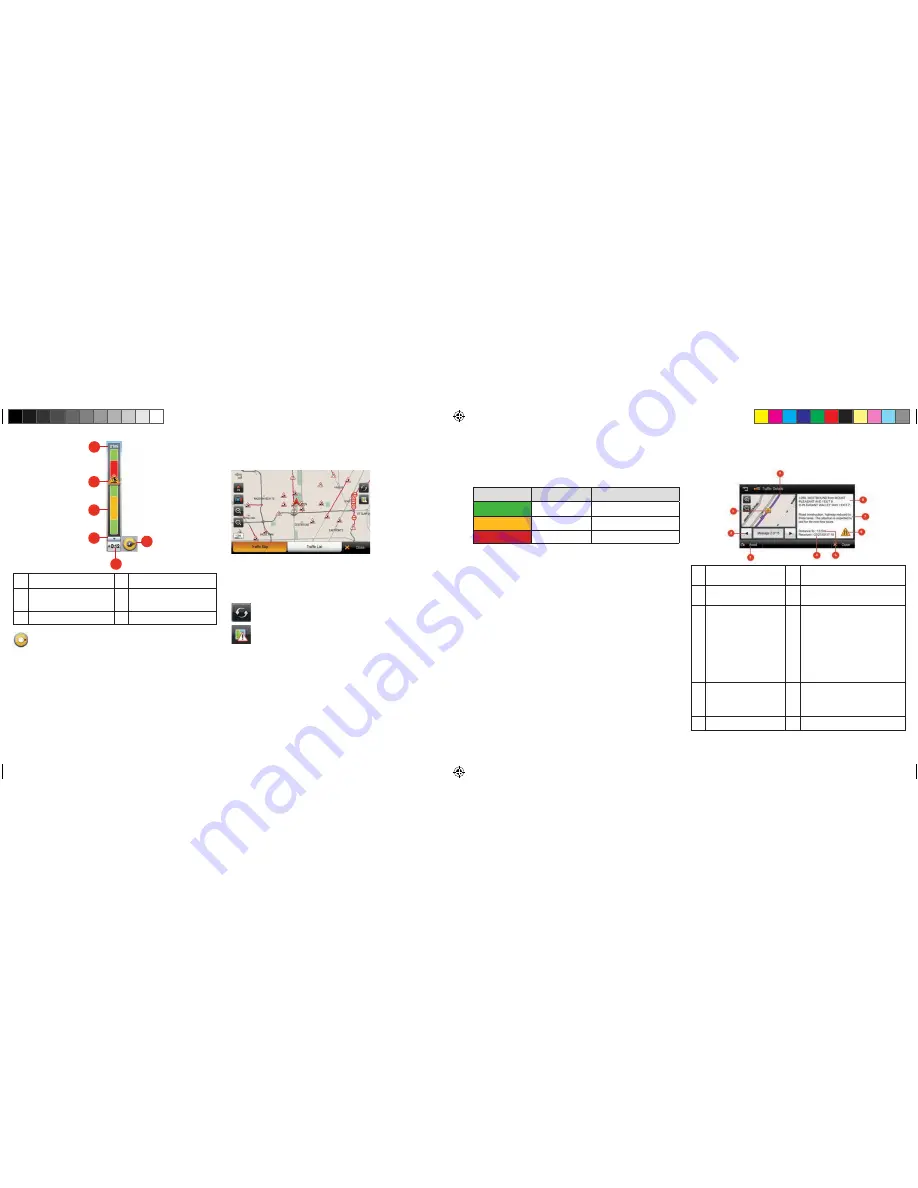
Traffic Details


At times, you may need to get more information on a specific traffic event. When in the 

Traffic map or Traffic List screen, simply tap any event for more details. 

1

Traffic Event Icon. The icon is 

placed at the start of the incident. 

6

Traffic Event Icon. In this example, the 

icon means ‘Lane Reduction’.

2

Next and Previous. You can scroll 

through the list of traffic events.

7

Detailed description of the traffic event. 

3

Avoid / Cancel. Tap [AVOID] to 

reroute around the traffic event. 

You may only avoid ‘On Route’ 

traffic events. The [CANCEL] 

button will only appear for events 

that you have asked to avoid. 

Tap [CANCEL] to remove the 

avoidance condition for this event. 

This means that navigation will 

no longer try to avoid this event.

8

Road, Direction, Start and End Junctions 

of the event. 

4

Time the traffic message was 

received or updated.

9

The magenta line indicates the ‘extent’ of 

the traffic event. The arrow head is placed 

at the end of the incident and indicates 

the traffic travel direction.

5

Distance to the traffic event

Color

Meaning

Speed Range

Fast

Normal

Slow

23-40 MPH (36-64 km/hr.)

Heavy

0-22 MPH (1-35 km/hr.)

8200PROHD_MANL.indd   15

11/7/13   4:59 PM

Summary of Contents for 6500 PRO HD

Page 1: ...PROFESSIONAL NAVIGATION 8200 PRO HD USER MANUAL 8200 PRO HD USER MANUAL 2013 Cobra Electronics Corporation Part No 480 923 P Printed in China 8200PROHD_MANL indd 1 11 7 13 4 59 PM...

Page 2: ...licable federal state and local laws rules and regulations The contents of this document software and data are for informational use only and are subject to change without notice Cobra and its licenso...

Page 3: ...u will see the above screen You must select your vehicle type car or truck and agree to the safety terms and conditions in order to use the navigation device When selecting a truck as your vehicle typ...

Page 4: ...of next street in route 8 Estimated Time of Arrival ETA and Time To Go 17 Lane guidance 9 Traffic Bar Route Preview The route preview screen will appear each time you set a new destination or enter a...

Page 5: ...ation tab provides access to location specific information Traffic Tab The traffic tab provides access to live traffic information Route Tab The route tab provides access to route specific functions a...

Page 6: ...shown If you would like to change state province tap the State Name button For State Province search you can search by either the full name e g New York or the abbreviation e g NY 3 Search for a city...

Page 7: ...tton You can search for POIs near your current location using the POI category search First simply select the category you wish to use for example Fuel Auto then select a POI from the result list The...

Page 8: ...ould like when you have selected all the desired categories tap APPLY The list of truck stops will now be filtered to display only the truck stops that have the amenities you desire Favorites Tap the...

Page 9: ...reen examples to ensure the coordinate you enter is in a valid format Multi Route Save and restore commonly used routes The Multi Route interface allows you to save and restore routes that you commonl...

Page 10: ...ore the restriction 2 switch to car mode 3 cancel the route If you choose to Ignore Restriction the route given in navigation will use the restricted area of road highlighted on the map If you choose...

Page 11: ...bited due to its trailer length Weight restriction displayed when you are approaching a location for which your current vehicle is prohibited due to its weight Width restriction displayed when you are...

Page 12: ...ations added become the destination and previously added locations become waypoints Find POI nearby any location Simply select the location and choose SHOW ON MAP MORE FIND NEARBY POI After selecting...

Page 13: ...inserted into your device In order to restore favorites mileage log you will need to have a SD card inserted that has the required files saved onto the root directory of the SD card In order to backu...

Page 14: ...you can individually enter each sub category for that truck parameter When travelling from the US to Canada or vice versa routing in the other country will be based on our closest match to your truck...

Page 15: ...Distance from current position 2 Traffic Congestion Extent 5 Traffic Status Icon Tap to go to Traffic Details 3 Traffic Incident 6 Estimated Delay 2 Traffic Flow The Traffic map contains traffic flow...

Page 16: ...rom this traffic event class appears on my route Predictive Traffic You may additionally display predictive traffic information on the traffic map Predictive traffic is based on historic traffic patte...

Page 17: ...Auto mode Daytime Daytime color scheme Nighttime Nighttime color scheme Auto Automatically change the map scheme Map Colors You can change the map color By touching the map images change day or night...

Page 18: ...view screen Consumption The consumption section allows you to set your vehicle s fuel con sumption This fuel consumption will then be used in the cost estimate for your trip Most modern vehicles inclu...

Page 19: ...ncluding warranties of merchantability and fitness for a particular purpose are limited in duration to the term of this warranty COBRA SHALL NOT BE LIABLE FOR ANY INCIDENTAL CONSEQUENTIAL OR OTHER DAM...

Page 20: ...puter files and distributor of derived information products under Agreement number 6776 The product is sourced in part from Statistics Canada computer files including 2009 Road Network File RNF 92 500...

Reviews: