SECTION 4. SENSOR INSTALLATION
4-11
Subtract declination from 360
°
Add declination to 0
°
22 E
18 E
16 E
14 E
12 E
10 E
8 E
6 E
4 E
2 E
0
2 W
4 W
6 W
8 W
10 W
14 W
12 W
16 W
18 W
20 W
20 E
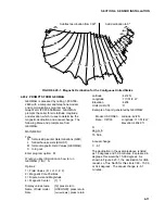
FIGURE 4.20-1. Magnetic Declination for the Contiguous United States
4.20.2 PROMPTS FROM GEOMAG
GEOMAG is accessed by calling 1-800-358-
2663 with a computer and telephone modem,
and communications program such as
GraphTerm (PC208 Software). GEOMAG
prompts the caller for site latitude, longitude,
and elevation, which it uses to determine the
magnetic declination and annual change. The
following Menu and prompts are from
GEOMAG:
MAIN MENU
Type
Q for Quick Epicenter Determinations (QED)
L for Earthquake Lists (EQLIST)
M for Geomagnetic Field Values (GEOMAG)
X to log out
Enter program option: M
Would you like information on how to run
GEOMAG (Y/N)? N
Options:
1 = Field Values (D, I, H, X, Z, F)
2 = Magnetic Pole Positions
3 = Dipole Axis and Magnitude
4 = Magnetic Center
[1] : 1
Display values twice
[N]: press return
Name of field model
[USCON90]: press return
Date
[current date]:
press return
Latitude
: 42/2 N
Longitude
: 111/51/2 W
Elevation
: 4454
Units (m/km/ft)
: ft
Example of report generated by GEOMAG:
Model: USCON90
Latitude: 42/2 N
Date : 7/27/93
Longitude: 111/51/2 W
Elevation: 4454.0 ft
D
deg min
15 59.6
Annual change:
0 -6.1
The declination in the example above is listed
as 15 degrees and 59.6 minutes. Expressed in
degrees, this would be 15.99 degrees. As
shown in Figure 4.20-1, the declination for Utah
is east, so True North for this site is 360 - 15.99,
or 344 degrees. The annual change is -6.1
minutes.


