background image

17

using your onix400 gPs receiver : the hot button

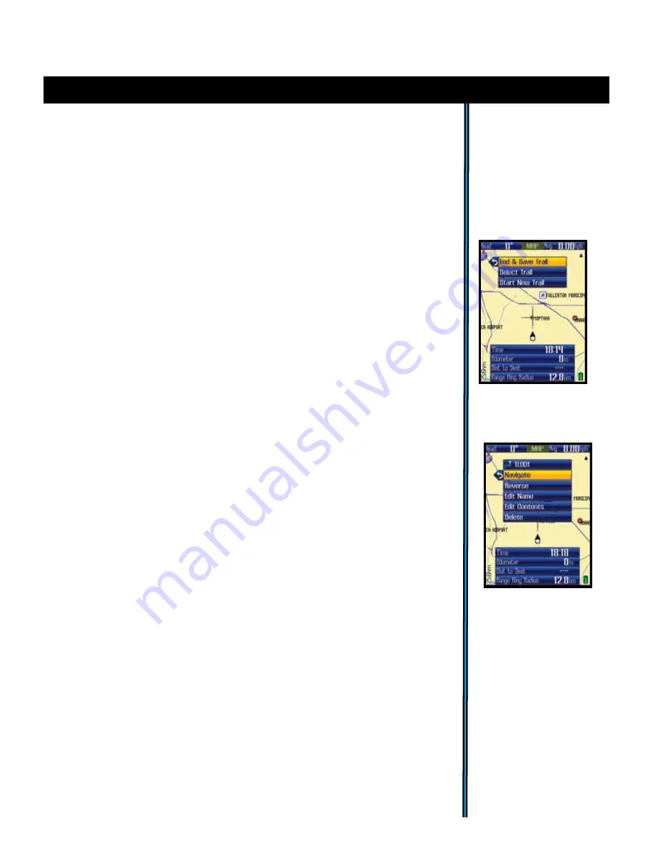
Fig 26.


My Trails-

Options after 

Select

ing 

a saved 

Trail

Following Find/GoTo, the next hot button menu item is: 
• 

My  Trails

.  A  trail  is  a  path  or  course  that  been  started  (by  moving)  or 

previously completed and saved by the user. Press OK or the right arrow. The 
three options here are (

Fig. 

25

):

• My Routes

 (same 5 options as listed above for “My Trails”)-a Route is the 

most direct or shortest path between two points.“Routes” are more often used 
for water based navigation (due to the reduced number of natural obstacles), 
whereas “trails” are more useful on land.

• My Photos

 -you have the options here to navigate towards a stored satellite 

photo or topo map, and to manage them (photos & maps are downloaded, not 
user created).

Start New Trail

: select this to begin a new trail, for example, from a 

parking lot or other landmark to your camp.

Select Trail

-displays the list of previously saved trails by name. Highlight 

a trail and press OK to see these 5 options (

Fig.

26

): 

End & Save Trail

: select this when you reach the end of a new trail, 

saving it in memory for later recall. You will have the option of naming 
the trail so it is easy to find in your “My Trails” list. 

Note: this option will 

only be seen if you are already actively navigating a trail you started.

a) Navigate

: navigate a saved trail. This starts navigation through 

a previously completed trail. 

b)  Reverse

-press  OK  to  navigate  the  selected  trail  from  its 

endpoint  to  its  start  (very  useful  to  “go  back”  to  a  point  of 
origin) 

c)  Edit  Name

:  option  to  rename  a  previously  saved  trail. 

Especially useful if you saved a trail with the “default” name.

d) Edit Contents

: allows you to view (press OK), delete or edit 

the details (name, etc) of a previous saved trail.

e) Delete

deletes a previously saved trail from memory.

the ONIX will begin to point you towards that area. (Note that you must 
have  selected  photos  or  topos  as  a  screen  layer  in  your  MAP  options 
as  described  earlier  on  page  9  if  you  want  to  see  it  while  navigating.) 
Alternatively, instead of pressing OK, you can right arrow from the name 
on the list and go to the “eyeball” icon, then press OK to just view the 
photo or topo without starting navigation. To exit this “view only” mode, 
press OK again to return to the list. 

8) Location

-a latitude and longitude coordinate

Fig 25.


My Trails

Options

Summary of Contents for ONIX 400

Page 1: ...ONIX 400 GPS XM RADIO RECEIVER Quick Start Guide Model 364000 Lit 98 0973 05 07 English...

Page 2: ...rs Do not use this product while driving An accident can result in property damage injury or death if the operator fails to practice prudent driving practices It is the sole responsibility of the driv...

Page 3: ...each After that practice using the Hot button and 5 way button to see and select from a menu of options perhaps on the SET screen by setting a few personal preferences for information displays Once yo...

Page 4: ...and checks the battery compartment following any submersion or prolonged exposure to rain snow etc Any moisture observed inside the battery compartment or on the exterior of the battery pack or MicroS...

Page 5: ...XM Radio Preferences Power Button located on right side of ONIX Push to turn on Once the unit is on press briefly to see the Power Menu Hold button for 2 sec to turn power off USB Port connect to PC...

Page 6: ...0 channels of music news sports and entertainment XM reception must be activated Listen to your favorites while you navigate or just listen at the end of the day when you reach your campsite boat or h...

Page 7: ...to navigate Note that the satellite lock process will take longer up to 3 or 4 minutes the first time you use your GPS in a new geographical area but will be much faster on future useage in the same...

Page 8: ...y height of current display e g 10 2km span from top to bottom of screen Use the and buttons to change the zoom level MAP Page Layering Options You may choose to add other items to your view of the MA...

Page 9: ...ur ONIX to choose the correct photo automatically based on your current location and zoom level Note that while both types of images can be stored at the same time on your ONIX only one of them photo...

Page 10: ...x will change to display the local time your selection has replaced the previous type of info 6 Press DOWN to select the second Info Box and repeat steps 4 5 to change what is displayed in this box Re...

Page 11: ...o Box displays for different kinds of weather related info When finished press the LEFT button then EXIT and the Info Boxes will now show the various weather information you selected Fig 10b Note that...

Page 12: ...played in this box Then press the Right button and repeat to change the other data box Next press the Down button if you want to change the items displayed in the Info Boxes at the bottom of the scree...

Page 13: ...ht buttons to browse channels by XM Radio category such as Decades Country Sports Comedy News etc 5 The SAT Page Fig 17 As seen earlier in Getting Started The SAT page view is used to identify the qua...

Page 14: ...cation where you first powered up the ONIX Compass options to select your preferred navigation units Degrees Cardinal Letter or Mils and North Reference True or Magnetic Display allows adjustment of d...

Page 15: ...area Once it has locked into the satellites ideally 4 or more the satellite position icons will stop blinking and turn green you are ready to begin using the ONIX The next step is your choice you may...

Page 16: ...viously stored items not create a new one when using the Find GoTo feature After selecting your destination and pressing OK you The title of the destination will show in a yellow box at the top of the...

Page 17: ...il saving it in memory for later recall You will have the option of naming the trail so it is easy to find in your My Trails list Note this option will only be seen if you are already actively navigat...

Page 18: ...ontinuous signals The ONIX will automatically make GPS satellite contact every 5 minutes default can be changed in SafeTrack Options menu which extends battery life significantly while still allowing...

Page 19: ...the right arrow To access symbols press and hold the left arrow Hold the up arrow to access the Shift for upper case letters etc and Done when you are finished and ready to exit the text entry proced...

Page 20: ...o review and analyze and save for the next return trip BushnellGPS com also provides detailed GPS product features and specifications Software Update Downloads Troubleshooting and Frequently Asked Que...

Page 21: ...t further away from your body Unit freezes or locks up unable to turn off normally 1 Processing malfunction or similar cause 1 If holding the power button for 2 sec has no effect reset the unit by rem...

Page 22: ...ee that interference will not occur in a particular installation If this equipment does cause harmful interference to radio or television reception which can be determined by turning the equipment off...

Page 23: ...to the address listed below IN U S A Send To IN CANADA Send To Bushnell Outdoor Products Bushnell Outdoor Products Attn Repairs Attn Repairs 8500 Marshall Drive 25A East Pearce Street Unit 1 Lenexa K...

Page 24: ...007 Bushnell Outdoor Products For further questions or additional information please contact Bushnell Outdoor Products 9200 Cody Overland Park Kansas 66214 Customer Service 800 423 3537 www bushnell c...

Reviews: