SABRE
™
RANGER 5000 User Guide
© 2017 Addvalue Innovation Pte Ltd. All rights reserved.
23
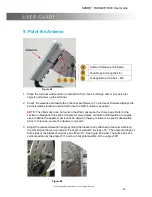
9. Point the Antenna
Figure 25
1. Place the terminal outdoor with no obstruction from trees, buildings, hills or any external
objects and power up the terminal.
2. Check the elevation and azimuth on the terminal firmware. The terminal firmware displays the
pre-calculated elevation and azimuth once the GPS location is acquired.
NOTE:
The information can be found in the Web console on the Home page. Refer to the
section on Navigate to the Web Console for more details. Azimuth and Elevation are angles
used to define the apparent position of an object in the sky, relative to a specific observation
point. In this case, we are the observers on earth.
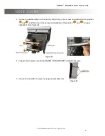
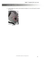
3. Adjust the required elevation angle by tilting the bracket body attached to the terminal along
the slot. Notice that you can adjust the angle of elevation in steps of 5°. The angle markings at
both sides of the bracket body have an offset of 5°. See figure 26 below. The terminal is at a
vertical position at the angle of 0° and at a horizontal position at the angle of 90°.
Figure 26
Centre of rotation point (fixed)
Variable point along the slot
Lock position with a bolt
– M5


