Pharos EZ Road Скачать руководство пользователя страница 4


1. Introduction to using the Pharos EZ Road GPS Navigator 


Thank you for choosing the 

Pharos EZ Road GPS Navigator

, an 

all-in-one device that enables you to be more efficient, organized, and 
travel smarter.  Please think of the users’ manual as a reference guide 
enabling you to get the most enjoyment and use from your 

Pharos EZ 

Road GPS Navigator

.


Summary of Features 


  Detailed street level mapping data 
  Mapping “Points of Reference” (PoR) by address, intersection, points of 

interest, longitude/latitude or contacts 

  Routing from one “PoR” to another, with the ability to create up to 10 

intermittent stops in a route 

  Open up to 10 maps at a time 
  Driving directions and route guidance 
  Display street name by tapping on map 
  Zoom in / zoom out 
  Personal “Favorites” database 
  GPS status indicators, with on screen strength and position indicator 
  Real time route simulation (only when GPS is disabled) 
  Text directions 
  Three navigation views 
  Night time display of maps 
  When navigating:  

o

  Three routing methods: Fastest, Shortest, Avoid freeways. 

o

  Street name of the next turn at the bottom of screen. 

o

  Displays distance and direction of the next turn. 

o

  Displays distance to your final destination. 

o

  Screen displays: Map, Split map / arrow, and Arrow views. 

o

  Audible Voice prompt route guidance. 

o

  Auto zoom-in before and after change in trajectory. 

o

  Trip-trace recording of the route traveled. 

o

  Compass mode with time, heading, latitude, longitude, altitude, 

rate of travel, relative distance and direction to destination. 

o

  GPS position is origin while on street with GPS locked. 

o

  Auto re-route option, or one-touch Re-route button. 

o


Moving map while navigating with the GPS receiver.


o

  Selectable “North Up” or “Heading Up” for map display. 

o

  Selectable “on” or “off” for voice prompt. 


2. Copying Maps and Installing MapFinder 
 

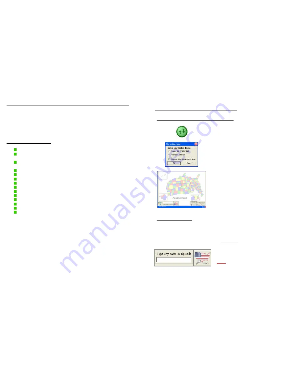
2.1 Get Connected and Using MapFinder


Microsoft ActiveSync 

1) Make sure EZ Road is connected to 
your PC through Microsoft ActiveSync. 


MapFinder is opened from your Start 
Menu. (Usually found in Programs)  
When first starting MapFinder select 
“Pharos EZ Road”


MapFinder helps you to determine 
which maps you need, select the map 
or maps you wish to use, and copy the 
maps to your PC or storage card.  You 
can also browse map data and 
features. 

 
*Have your map CDs ready, as you 
may need to insert them in your CD-
rom drive during installation or 
copying.


2.2 Selecting Maps 
 

There are two methods used to select a map(s) you want to use.


1. 

Searching


A) Enter a 

city name

 or 

zip code

 and 

click “Search” 
 

Note:


A zip code is the most precise 

way to search.  Areas on the edge of 
maps may need more than one map 
to travel efficiently.


Содержание EZ Road

Страница 1: ...erence only The user is expected to follow the traffic signs and local regulations Do not leave the product in direct sunlight or heat for extended periods of time Overheating the battery can be dange...

Страница 2: ...ar CAUTION Always make sure to start your vehicle FIRST before connecting the in vehicle charger to prevent damage from sudden current changes 1 Connect the USB Charging Cable to the EZ Road unit and...

Страница 3: ...ABLE OF CONTENTS 1 Introduction to using the Pharos EZ Road GPS Navigator 1 2 Copying Maps and Installing MapFinder 2 2 1 Get Connected and Using MapFinder 2 2 2 Selecting Maps 2 2 3 Extracting Transf...

Страница 4: ...plit map arrow and Arrow views o Audible Voice prompt route guidance o Auto zoom in before and after change in trajectory o Trip trace recording of the route traveled o Compass mode with time heading...

Страница 5: ...electing maps they need to be extracted and sent to the My Documents folder on the SD MMC memory card in your EZ Road or card reader After selecting maps the top right corner of the screen has two opt...

Страница 6: ...nimize Minimizes MapFinder Exit Exits MapFinder completely 6 3 EZ Road User Interface Menus Common Terms 3 1 Main EZ Road Menu Ostia Navigator Starts the Ostia navigation software Contacts Contacts ad...

Страница 7: ...Lat Long or GPS position Options configure basic options for using Ostia 8 3 3 Terms and Abbreviations Point of Reference PoR Any item used to define a specific point or coordinate used in navigation...

Страница 8: ...e screen Note 1 through 3 must be repeated to open multiple maps 4 2 Finding Origins Destinations and Creating Routes There are 2 methods to find a route active and pre planned The Active Method is us...

Страница 9: ...Code box at the bottom of the screen to display zip codes Choose a city from the list below then Next 4 You have the option to save the location as a Favorite or Home IMPORTANT GPS is Powered On by d...

Страница 10: ...el Approximate o speed o altitude o line of sight distance o global time The red line is the general direction of your destination 6 View Options for Ostia Tapping this icon will cycle through the thr...

Страница 11: ...ccess to a large active POI database Smart Mapper capability to download maps to your device 16 These services are accessible via Internet through ActiveSync and require subscription from Pharos www P...

Страница 12: ...and Longitude of each Favorite Continued on next page 18 Options Brings up the menu screen Auto Re route When selected this option will automatically recalculate the route to the destination if you de...

Страница 13: ...Software you agree to be bound by the term of the Agreement If you do not agree to the terms of this Agreement promptly return the software and its accompanying items to the retailer 1 Grant of Licens...

Страница 14: ...Software including but not limited to any images photographs animations video audio music and or text incorporated into the Software the accompanying printed materials and any copies of the Software a...

Отзывы: