


17
shown with this option.
Favorites that have been stored in the system can be viewed
and deleted.
Clear…
This function will clear any of the following off of the map screen:
- Smart Finder icons
- Smart Traffic icons
- Trip Trace
- Favorites
- A Route
- Multi-stops
Destination
Displays current Destination
Origin
Displays current Origin
Multi-stop
Displays Multi-stops
Full Route
Displays entire route from Origin to Destination
7.4 Tools
Simulation
Simulation:
after a route is set, the software can run a
simulation as though you were actually traveling in real time.
*Will not work while GPS is Enabled.
Record Trip
Trace
This function can be set up to
leave markers along a route at
set intervals to record the points you have traveled across.
Store
Favorites
Store Favorite
Store a latitude and longitude point on the map
or current GPS position to be stored as a Favorite.
Export
Favorites
This function exports the list of all Favorites to a directory you
specify which contains the name of each favorite along with the
Latitude and Longitude of each Favorite.
Continued on next page >>
18
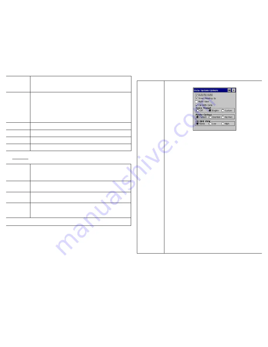
Options…
Brings up the menu screen:
•
Auto Re-route – When selected this option will automatically
recalculate the route to the destination if you deviate from the
original route.
•
Smart Heading Up – When selected this will orient the map
screen to always have the direction you are traveling in as the
top of the map. If this is unselected, north will be the top of
the map.
•
Night View – When selected this will apply the night colors to
the map. When unselected daytime colors will apply.
•
Car with Circle – When selected this will place a white ‘halo’
circle around the red GPS position arrow on the map to help
aid in making in easier to see.
•
Voice Prompt – This will allow either English or a Custom
voice prompt to be used for navigation or to turn off the voice
prompts.
•
Route Options – How a route is calculated is selected here:
- Fastest (Default) – The route is calculated based on the
fastest speed limits of available roads.
- Shortest – The route is calculated on the most direct route
to the destination from the origin.
- No Hwy – The route will be calculated without using any
highways.
•
3D Bird View – This will change the angle at which the map
will be viewed on the screen for navigation.