
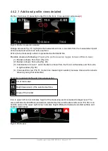


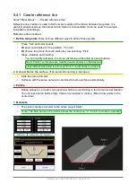
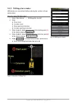


5.4.1 Create reference line
Select “
Operations
” → “
Create reference line
”
Reference line creation is used to form simple models of the terrain between two points. It is
useful in situations where the actual terrain model is not available. It can be used, for example,
foundations of buildings.
Reference line creation:
1.
Define two points
(there is three different ways to define these points)
•
Press “List” and select points
•
Or
enter coordinates for the points(X, Y and Z)
•
Or
choose the points from the work site view selecting “Pick”
•
Slope, distance and heading:
◦
You can modify reference line slope, distance and heading by using buttons.
Note! Point2 coordinates are modified automatically so that desired
slope/distance/heading is achieved. Point1 coordinates are fixed.
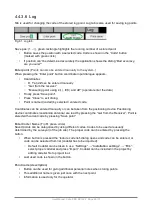
2. Optional:
Name the surface
(If an automatic naming is improper)
•
Click the name and edit.
•
Surfaces with the same name are combined to same surface automatically.
3.
Profile
•
Define values for a model cross section which are used during in the terrain model creation.
You can leave some fields empty. Values are inserted in metres. (Blue arrow points to the
center-line)
4.
Generate
•
The system creates a model to the active project folder.
•
Note: The blue arrow in the picture shows the center-line, “0”. Point1 is closer to operator
User Manual. Xsite PRO SPI 14.2 Page 54 / 77
Содержание XSITE PRO SPI 14.2
Страница 1: ...XSITE PRO SPI 14 2 USER MANUAL Version 1 14 2 46 October 2018...
Страница 33: ...Fig 36 Tilt bucket calibration User Manual Xsite PRO SPI 14 2 Page 30 77...
Страница 76: ...User Manual Xsite PRO SPI 14 2 Page 73 77...
Страница 77: ...User Manual Xsite PRO SPI 14 2 Page 74 77...
Страница 78: ...User Manual Xsite PRO SPI 14 2 Page 75 77...
Страница 79: ...User Manual Xsite PRO SPI 14 2 Page 76 77...


