

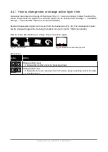


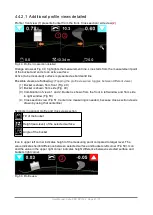


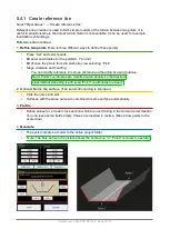
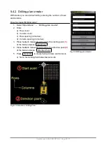


Fig. 58 Distance to the selected line.
P
, Station number
Station number represents the distance which is measured from the start of a line model along
the centre line. Distance can be defined to begin, for example, at 100 metres. When undefined,
“P” displays the distance in metres from beginning of the line.
Satellite count
(here are 7 active satellites. Marked with red circle in Fig. 56)
The background colour of the field indicates the state of the RTK correction. State have to be
“FIX” (field is green) for most accurate work. More information about accuracy is in section
“GNSS accuracy test”.
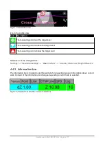
•
Satellite panel tapping stores the point (as-built data) to the selected surface.
“As-built” points are always stored to current layer. For example, if you are working with DTM
model and the model / layer name is "Final surface" then all points are store to “Final surface”
layer. This can also be seen in the “as-built” data file when it is exported from the system.
User Manual. Xsite PRO SPI 14.2 Page 46 / 77
Содержание XSITE PRO SPI 14.2
Страница 1: ...XSITE PRO SPI 14 2 USER MANUAL Version 1 14 2 46 October 2018...
Страница 33: ...Fig 36 Tilt bucket calibration User Manual Xsite PRO SPI 14 2 Page 30 77...
Страница 76: ...User Manual Xsite PRO SPI 14 2 Page 73 77...
Страница 77: ...User Manual Xsite PRO SPI 14 2 Page 74 77...
Страница 78: ...User Manual Xsite PRO SPI 14 2 Page 75 77...
Страница 79: ...User Manual Xsite PRO SPI 14 2 Page 76 77...


