background image

Magellan NAV 6000

31

Use the 

CURSOR KEY

 to highlight the waypoint you wish

to view and press the 

VIEW

 softkey.

The display returns to the Map screen, with the selected
waypoint in the center of the map, under the cursor.

The information window at the bottom of the map shows
the waypoint name, scale, bearing/distance from the present
position to the waypoint being viewed, message and coordi-
nates.

Editing a Waypoint from the Waypoint List

This function enables you to change the name, icon, coordi-
nates, and/or description of a previously saved waypoint.

From any root screen, press the 

MENU 

softkey, highlight

Waypoints 

and press 

ENTER.

 Use the 

CURSOR KEY

 to

highlight the waypoint in the list you wish to edit.

Press 

ENTER

 to edit the highlighted waypoint. The EDIT

WAYPOINT window appears. You can change the
waypoint name, waypoint icon, coordinates, description,
or you can accept the default values.  When the informa-
tion for the waypoint is correct, press 

Done

.

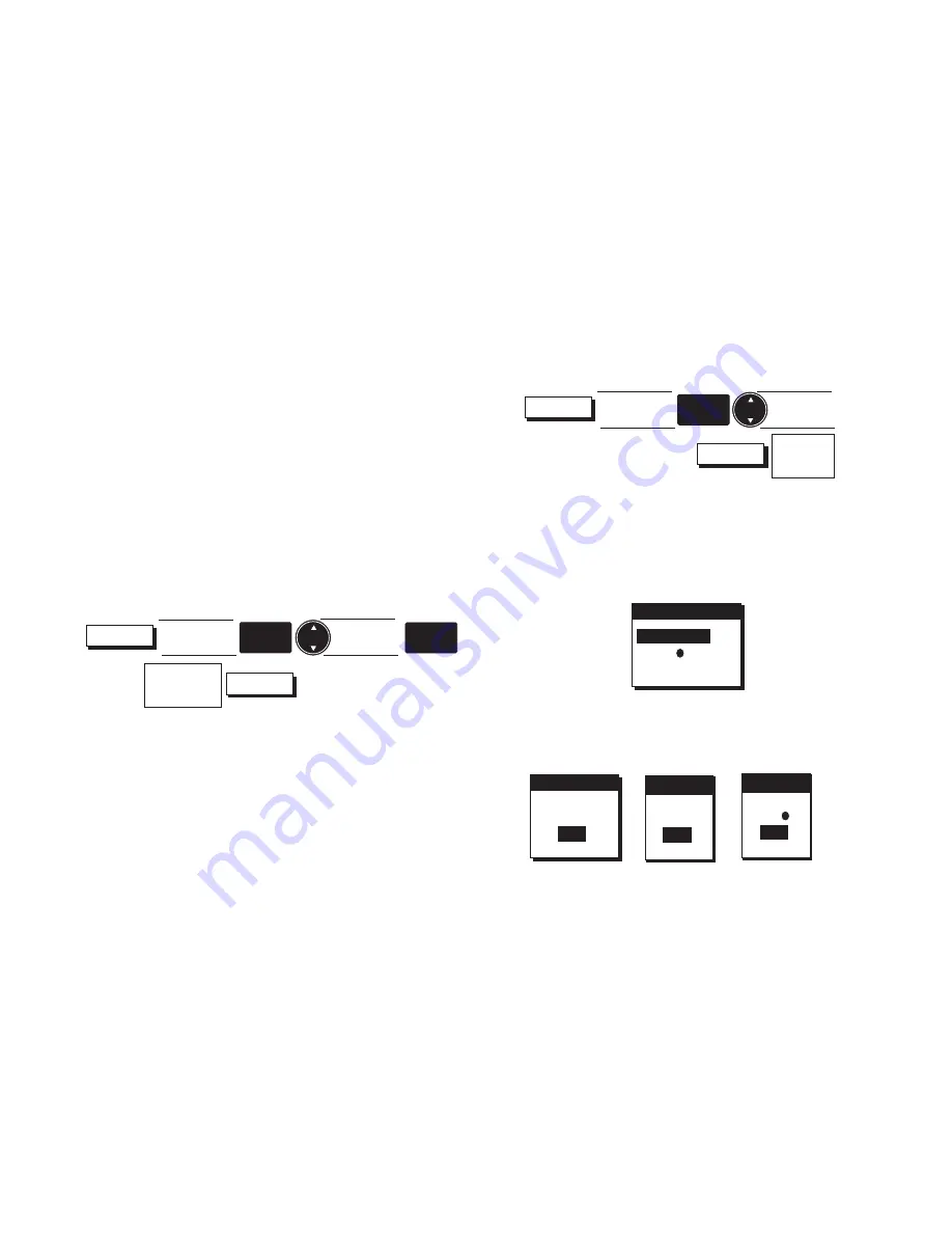
Deleting Waypoints from the Waypoint List

From any root screen press 

MENU

, highlight Waypoints and

press 

ENTER.

Use the 

CURSOR

 key to highlight the waypoint you wish to

delete, then press the 

DELETE

 softkey.

The DELETE WPT screen appears showing three fields:

Use the 

CURSOR

 key to highlight one of the options and

press 

ENTER to select.

One of the following confirmation screens appears.

DELETE WPT

WPT005  ?

TYPE   ?

ALL?

CONFIRM

  DELETE

WPT005  ?


YES

    NO

CONFIRM

  DELETE

   ALL?


YES

    NO

CONFIRM

  DELETE

 TYPE  ?


YES

    NO

Highlight
Waypoint

ENTER

Modify or

Accept

Default Data

Done

MENU

Highlight
Waypoints

ENTER

Highlight
Waypoint

Delete

Confirm

Delete

MENU

Highlight
Waypoints

ENTER

Содержание NAV6000

Страница 1: ...Magellan NAV 6000 User Manual Magellan NAV 6000 User Manual...

Страница 2: ...smitted in any form or by any means electronic or mechanical including photocopying and recording for any purpose other than the purchaser s personal use without the written permission of Magellan Sys...

Страница 3: ...Repairs under this warranty shall only be made at an authorized Magellan Service Center 3 PURCHASER S DUTIES To obtain warranty service the purchaser must return the receiver or accessories postpaid...

Страница 4: ...respon sible for such damages even if Magellan Systems Corporation has been advised of the possibility of such damages Some states do not allow the exclusion or limitation of incidental or consequent...

Страница 5: ...Magellan NAV 6000 User Manual...

Страница 6: ...data with extreme caution USE PROPER ACCESSORIES Use only Magellan cables and antennas the use of non Magellan cables and antennas may severely degrade performance or damage the receiver and will void...

Страница 7: ...Satellite Status Screen 17 Map Screen 19 Setting the Map Scale 20 Using the Cursor Key on the Map Screen 21 Map Orientation 21 Plotter Mode 22 Viewing Waypoint and Navaid Attributes 23 Finding Distanc...

Страница 8: ...ting a Waypoint in a Route Manually 39 Removing a Waypoint from a Route 40 Appending a Waypoint to the End of a Route on the Map 40 Appending a Waypoint to the End of a Route Manually 41 Moving a Wayp...

Страница 9: ...r Off 56 Choosing the Distance Resolution 56 Clearing Track Memory 56 Trip Planning Function 56 Calculating Sunrise Sunset and Lunar Information 57 Simulation Mode Function 58 Memory Reset 58 Troubles...

Страница 10: ......

Страница 11: ...your receiver for use and provides basic instruc tion for getting you up and running with your GPS receiver The fourth chapter is a Reference Section for the features found in your receiver including...

Страница 12: ...common terms are described here with a simple explanation as to their meaning Position Fix The NAV 6000 receives information from GPS satellites to compute a value coordinates that describes your uniq...

Страница 13: ...attempt to operate it See the Installation section in the Appendix for details on mounting and connecting the NAV 6000 Keys ZOOM IN Changes the displayed map scale to view a smaller area in greater de...

Страница 14: ...le Using the Help Bar The map screen and many of the func tion screens contain a help bar located just above the NAV window which tells you which action or actions you may perform on the current scree...

Страница 15: ...ftkeys for a different language or press ENTER to con tinue To turn power off Press and hold down the POWER key The receiver will begin a countdown sequence that will last for 5 seconds The window wil...

Страница 16: ...as a point of reference for your receiver in selecting the best satellites to use Without know ing its approximate location the receiver may take 10 min utes or more to find the specific coordinates...

Страница 17: ...IN ZOOM OUT keys to help you determine whether the cursor is active in the right part of the globe Some basic knowl edge of continental land masses is helpful If the cursor is not in your region of th...

Страница 18: ...mpute navigation information If you do not have a position fix the navigation information will be displayed with dashes until a position fix is acquired The format of the coordinates displayed can be...

Страница 19: ...Some of the steps and features displayed can be performed in other manners The objective here is to demonstrate the cre ation of waypoints and routes using the Map Screen The first step is to look at...

Страница 20: ...CURSOR POSITION Name Type DESCRIPTION CURSOR WPT001 MAR 17 96 03 35 40 PM 33 05 45 N 118 14 81 W 0F T Los Angel WPT001 WPT002 Los Angel WPT001 The next step is to create a second waypoint This is don...

Страница 21: ...g point for creating a route The first step will be to de fine the starting location for the route Move the cursor to WPT001 as this will be the starting waypoint for the route Press ENTER Move the cu...

Страница 22: ...ing a Waypoint A waypoint can be inserted in a route To accomplish this move the cursor until it is close to the leg where the new waypoint will be inserted and the Insert softkey becomes active MANUA...

Страница 23: ...function is removing a waypoint from a route Move the cursor to the waypoint to be removed from the route Please note that the waypoint is not removed from the receiver s memory but only from this ro...

Страница 24: ...appears briefly Activate Route x is active Press QUIT twice to exit The next time you access the Route List the letter A appears next to the active route The display returns to the route map screen s...

Страница 25: ...e navigation warning screen press one of the softkeys for a differ ent language or press ENTER to continue 4 R Refer eference ence Hold down to start countdown POWER Los Angel TO WPT023 SCALE 243 BRG...

Страница 26: ...e bottom of the screen press ing QUIT twice to back out of the Setup and Function Menu screens and return to the last viewed root screen Adjusting Backlighting Adjust backlighting to two different lev...

Страница 27: ...AM L O W L O W Satellite Status Screen The first screen after the navigation warning screen is the Sat ellite Status screen This screen displays information relating to the satellites being tracked se...

Страница 28: ...fixes and moving faster than 0 2 mph a line from the center to the outer circle points in the direction of COG The direction of the line is updated when ever COG changes When the unit starts computing...

Страница 29: ...of Guinea See Initializing On the bottom of the screen an information window dis plays the name of the destination waypoint of the active route if any the bearing and distance from the present positi...

Страница 30: ...ter D appears at the top right corner of the screen Setting the Map Scale ZOOM IN ZOOM OUT The map screen first appears in the highest scale setting Use the ZOOM IN and ZOOM OUT keys to zero in on a s...

Страница 31: ...re else on the map and is not shown on the screen that cursor position is lost The destination name is replaced with the word cursor and the cursor coordinates WGS84 only are displayed on the bottom l...

Страница 32: ...on automatically even if they are off in the Map Configuration The Plotter Mode then plots the route you are traveling on a grid show ing coordinates without background cartography A north arrow indic...

Страница 33: ...ct icon object at tributes appear instantly on the map screen in a QUICK INFO window giving an ab breviated description of that object or objects The abbre viated description is similar in format and...

Страница 34: ...aids are listed below along with their at tributes If there is additional information on other pages you can use the PAGEDN softkey to display them When you have finished viewing attributes press QUIT...

Страница 35: ...G to switch to the Nav 2 screen Finding Distance and Bearing from a Point on the Map You can find the distance and bearing from one point to an other on the Map screen using a built in measuring stick...

Страница 36: ...ring navigation will allow you to reach your destination by staying close to your planned route These fields can be changed to include other information using the CUSTOM softkey The bottom of the NAV...

Страница 37: ...point Icon will represent the direction you should head to get back on course If the unit is not comput ing fixes due to poor signal reception the Pointer screen dis plays graphics based on the last C...

Страница 38: ...f a page it automatically continues on the next page if one exists When scrolling up the highlight automatically continues on the previous page if one exists The softkeys available from this screen ar...

Страница 39: ...Press up or down on the CURSOR KEY to scroll through the alphanumeric character list press left or right to move the cursor to the next character If you want to clear the entire name or description li...

Страница 40: ...t you are looking for Press ENTER when done and the receiver returns to the Waypoint List with the waypoint highlighted The receiver s fast search will allow you to select only names that are in the w...

Страница 41: ...Press ENTER to edit the highlighted waypoint The EDIT WAYPOINT window appears You can change the waypoint name waypoint icon coordinates description or you can accept the default values When the infor...

Страница 42: ...t Waypoints and press ENTER The waypoint list appears Press the NEARST softkey The waypoint list is in order of proximity to the cursor on GPS positions The screen header indicates whether they are ne...

Страница 43: ...ypoint Press the MOVE softkey As the help bar indicates move the CURSOR KEY to the new position on the map where you wish to move the se lected waypoint As you move the cursor to a new position a dott...

Страница 44: ...on to the selected waypoint Creating a GOTO Route Using the Find Function Press GOTO from any screen The Map screen appears and the active softkeys are LIST NEARST FIND and MOB Press the FIND softkey...

Страница 45: ...ting a MOB Route GOTO MOB The MOB or Man Over Board function allows you to instantly create a GOTO route to the GPS position at the time you pressed the GOTO key and MOB softkey Press GOTO from any sc...

Страница 46: ...osition and the MARK CURSOR POSITION window appears make the necessary edits and press DONE to accept adding the new waypoint to the route Continue to add waypoints to the route until you have complet...

Страница 47: ...and press the ACTVTE softkey The next time you view the route list an A appears next to the route number and A window appears briefly Route X is active The route which was previously active if any has...

Страница 48: ...e Map From any root screen press ROUTE LIST softkeys Use the CURSOR KEY to highlight the route in which you wish to insert a waypoint and press ENTER To edit the active route a shortcut is to press RO...

Страница 49: ...the position you placed it on the map Press DONE to exit Route Edit Inserting a Waypoint in a Route Manually From any root screen press ROUTES LIST softkeys Use the CURSOR KEY to highlight the route i...

Страница 50: ...the CURSOR KEY to highlight the route in which you wish to append a waypoint to the end and press EN TER To edit the active route a shortcut is to press ROUTES EDIT Use the CURSOR KEY to place the cur...

Страница 51: ...ENTER Press DONE QUIT to exit Route Edit If the list is very long you may access the Find Waypoint function in this list by pressing the FIND softkey You may also list the waypoints in order of proxim...

Страница 52: ...in the active route simply press ROUTES EDIT MANUAL softkeys Use the CURSOR KEY to highlight the waypoint you wish to replace and press ENTER The waypoint list appears Select the waypoint you wish to...

Страница 53: ...ting a Route in the List From any root screen press the ROUTES LIST softkeys Use the CURSOR KEY to highlight the route you wish to delete and press the DELETE softkey A confirmation window appears Del...

Страница 54: ...own continues until the last destination is reached and then the unit will indicate ARRIVED Note that a backtrack route is not the same as a regular route in that it cannot be edited reversed or copie...

Страница 55: ...TUP MENU press QUIT Adjusting Contrast The contrast can be changed for best screen viewing Press the MENU softkey from any of the navigation screens highlight System Setup and press ENTER The SETUP ME...

Страница 56: ...B Loran TD s Irish Swiss French German Swedish or Finnish Grid If latitude longitude is selected the position can be displayed in Degrees Minutes and fractions of minutes to 2 or 3 digits of resolutio...

Страница 57: ...NTER The SETUP MENU appears Use the CURSOR KEY to highlight Elev Mode press ENTER and a window opens showing elevation mode options Use the CURSOR KEY to highlight 2D or 3D Auto and press ENTER In 2D...

Страница 58: ...R Use the CURSOR KEY to highlight Feet Meters or Fathoms and press ENTER Default setting Feet When you have finished selecting units press QUIT to exit Selecting North Reference Direction related info...

Страница 59: ...use the CURSOR KEY to high light System Setup and press ENTER The SETUP MENU appears Use the CUR SOR KEY to highlight Port Setup press EN TER and a window opens showing the DATA PORT options NMEA and...

Страница 60: ...he alarm to be acti vated and press ENTER Default setting All Off Setting Arrival Radius If the alarm is on it will sound when the boat comes within a certain distance of the destination waypoint s of...

Страница 61: ...p can be configured to show the objects that best suit your navigation needs Object attributes can be viewed on the map if the object is turned on in Map Configuration Turning Land Settings On and Off...

Страница 62: ...e map can be turned on and off They include Ports and Services Attention Areas such as cau tion danger and restricted areas and offshore installations Tracks and Routes Light Settings Buoys and Beacon...

Страница 63: ...etic variation information points Chart Generation showing chart generation and nautical publica tion information New Objects defined in software upgrades Info Level amount of information given for ea...

Страница 64: ...s represented by a solid line extending from the boat in the direction of its COG and terminated with an Press the MENU softkey use the CURSOR KEY to high light Map Setup and press ENTER Use the CURSO...

Страница 65: ...current position to the cur sor When you have finished placing the cursor press EN TER As you travel you can check to see that you have shifted the boat s position properly by comparing other points...

Страница 66: ...emory removes the track stored in memory that is plot ted on the map To clear track Press the MENU softkey use the CURSOR KEY to high light Track History and press ENTER TheTRACK HISTORY menu appears...

Страница 67: ...w sunrise and lunar information at the most recent position fix orWAYPOINT for any other position Press ENTER If you select WAYPOINT the Find Waypoint function appears which allows you to enter the na...

Страница 68: ...hen you have finished Use the CURSOR KEY to highlight Simulation Activate and press ENTER Use the CURSOR KEY to highlight On and press ENTER Press QUIT to exit To deactivate simulation mode simply set...

Страница 69: ...6000 59 A confirmation screen appears Highlight YES and press ENTER A message confirms the memory clear If you select Clear All Memory the unit will turn off after a few seconds Turn the unit on again...

Страница 70: ...hat the antenna at the top of the unit has a clear unobstructed view of the sky 2 If using an external antenna check the antenna connections Make sure the coaxial cable is firmly secured to the back o...

Страница 71: ...C card installed 1 Make sure the C card is mounted all the way into the C card slot so it is locked in place 2 Check the C card contacts to make sure they are clean If dirt is collected on the gold co...

Страница 72: ...ear Warnings Alarms This message appears when po sition fix is more than 20 seconds old The alarm will sound when the message appears Is displayed when anchor alarm is on and boat moved more than X XX...

Страница 73: ...7 Electrical Connections 69 Connecting the DC Power NMEA Data Cable Optional 69 Connecting the PC Cable Optional 70 Proper External Antenna Installation 71 Navaid Icons 72 List of Available Datums 77...

Страница 74: ...ity Close the door by readjusting it and turning the fasteners a 1 4 turn to the right Even though a capacitor inside the unit can maintain memory for up to an hour it is recommended that you replace...

Страница 75: ...l the way in When it will go no further press the edge of the cartridge down gently until it rests in place behind the plastic catch To remove the cartridge turn the unit off and push the cartridge in...

Страница 76: ...st The beveled edge should be facing toward you It is possible that damage to the unit or the cartridge may occur if you attempt to insert the beveled edge of the cartridge first When inserting the ca...

Страница 77: ...d We do not recommend installing the NAV 6000 within 1 foot 0 3 meters of a magnetic compass or a flux gate sensor Autopilots and remote electronic compasses typically have flux gate sensors When deci...

Страница 78: ...001 WASHER 46 00237 000 SCREW 46 00238 000 The NAV 6000 Swivel Mounting Bracket is shipped fully assembled from the Magellan factory The exploded drawing at right shows the individual parts of the br...

Страница 79: ...Connect DC power per manufacturer s directions Connecting the DC Power NMEA Data Cable Op tional Electrical Connections Use the power data cable to connect the unit to an external power source and to...

Страница 80: ...ine Name IO AT Pin CARRIER DETECT RECEIVE DATA TRANSMIT DATA DATA TERMINAL READY SIGNAL GROUND DATA SET READY REQUEST TO SEND CLEAR TO SEND RING INDICATOR 1 2 3 4 5 6 7 8 9 PC Interface from AC Adapte...

Страница 81: ...hysical obstructions build ings large trees mountains etc will block satellite signals from reaching the receiver If the unit is unable to get a posi tion fix move the receiver antenna so it has a cle...

Страница 82: ...n tiguous zone Continental shelf area Custom zone Dumping ground Exclusive economic zone Fishery zone Fishing ground Free port area Harbour area administrative Incinera tion area Log pond Military pra...

Страница 83: ...d part Run way Sloping ground Square C Cairn Cartographic objects Closing line Cartographic symbol Cartographic line Cartographic area TEXT Line generic Text Area generic National Character Set Text I...

Страница 84: ...ation Marine farm culture Mast Meta objects Accuracy of data Compilation scale of data Horizontal datum of data Nautical publication information Production infor mation Sounding datum of data Survey r...

Страница 85: ...Floating dock Gate Grid iron Harbour facility Hulk Landing place Landing stairs Lock basin Oil barrier Pon toon Ramp Shoreline con struction Slipway Weir Small craft facility Production Objects Corre...

Страница 86: ...Magellan NAV 6000 76 Water Turbulence Tideway Water turbulence Weed Kelp Windmill Windmotor Wrecks...

Страница 87: ...ian Geodetic 1984 BOGOT Bogota Observatory BUKIT Bukit Rimpah CAMPO Campo Inchauspe CANAD Canada CAPE Cape CARTH Carthage CENAM Central America CHATH Chatham 1971 CHUAA Chau Astro CORRE Corrego Alegre...

Страница 88: ...ross track error direction to steer origin destination waypoint waypoint location bearing to destination and velocity toward the destination RMC Time latitude longitude speed heading and date VTG Trac...

Страница 89: ...aypoint Great Circle 1 2 3 4 5 6 7 8 9 10 11 12 BWC XXXXXX XXXX XX N XXXXX XX W XXX T XXX M XXX X N CCCC 1 UTC of Bearing 2 3 Lat N or S of waypoint 4 5 Long E or W of waypoint 6 7 Bearing True 8 9 Be...

Страница 90: ...steer L R 5 XTE units nautical miles 6 Status A arrival circle entered 7 Status A perpendicular passed at waypoint 8 9 Bearing origin to destination M T 10 Destination waypoint ID 11 12Bearing present...

Страница 91: ...of position 6 Status A Data valid V Data not valid GSA GPS DOP and Active Satellites GPS receiver operating mode satelites used in the navigation solution rproted by the GGA sen tence and DOP values 1...

Страница 92: ...ull fields are not required for unused sets when less than four sets are transmit ted RMB Generic Navigation Information immediately follows RMC 1 2 3 4 5 6 7 8 9 10 11 12 13 14 RMB A X XX a c c c c 1...

Страница 93: ...6 Longitude at UTC time E or W 7 Speed over ground knots 8 Course over ground degrees 9 Date DDMMYY 10 Magnetic variation degrees 11 Magnetic variation sense E or W 12 CHECKSUM Mandatory in this sent...

Страница 94: ...P CTR Map Center key CTS Course to steer DEG Degrees DST Distance to go ENT ENTER EPE Estimated position error ETA Estimated time of arrival FM Fathoms Ft Feet GPS Global Positioning System HDOP Horiz...

Страница 95: ...m used in Great Britain POS Receiver generated name for current position POWER Power Key SA Selective Availability SEC Seconds SET REF Set reference SOG Speed over ground SPD Speed STR Direction to st...

Страница 96: ...ond RMS Speed limit up to 951 MPH 1 530 kilometers per hour Time to First Fix Cold start less than 1 minute Warm start 30 seconds Warm start the receiver has obtained a position fix within the last 2...

Страница 97: ...ibed as being the intersection of a line of latitude and a line of longitude Specifically a position is up to 90 degrees north or south of the equator up to the poles which are 90 N and 90 S the equat...

Страница 98: ...2 23 24 26 27 28 29 31 32 33 34 36 37 38 39 41 42 43 44 46 47 48 49 51 52 53 54 56 57 58 59 Other Coordinate Systems OSGB coordinates are similar to UTMs but they describe only Great Britain They must...

Страница 99: ...n anyone anticipated DoD has decided that 25 meter ac GPS is a constellation of navigation satellites that orbit the earth The precise time and position information transmitted by these satellites is...

Страница 100: ...dio beacon at the control site to any differential beacon receiver that is within range of the signal The differential beacon receiver receives and demodulates the signal then relays it to the user s...

Страница 101: ...aring that projects from your current position to a point B1 on the courseline mid way between a point B2 perpen dicular to your position and the current destination waypoint B DST Distance to go to a...

Страница 102: ...velling on a course that would not intercept the destination waypoint As the boat moved along less and less of its velocity would be applied toward arriving at the destina tion By the time point D is...

Страница 103: ...t perpen dicular to your position and the current leg destination waypoint Datum Refers to the theoretical mathematical model of the earth s sea level surface Map makers may use a different model to c...

Страница 104: ...s with the first leg being from waypoint A to waypoint B Longitude The angular distance east or west of the prime meridian Greenwich meridian as measured by lines perpendicular to the parallels and co...

Страница 105: ...by converting from LAT LON Time To Go The estimated time for the receiver to reach the destination from its current position based on the current VMG True North The direction to the geographical North...

Страница 106: ...45 Coordinate System 46 87 Customizing the NAV 1 screen 25 NAV 2 screen 26 Data input 16 Data terms 91 Date format 46 Datums 47 77 Distance Units 48 finding distance and bearing on map 25 DGPS 90 Dep...

Страница 107: ...editing 38 inserting a waypoint in a route 38 39 moving a waypoint in a route 41 removing a waypoint 40 replacing a waypoint in a route 42 reversing 38 route list 33 Sat Status 17 Setup 45 Signal rece...

Страница 108: ...Magellan NAV 6000 98...

Страница 109: ......

Страница 110: ...22 10311 001 960 Overland Court San Dimas CA 91773 USA 909 394 5000 SYSTEMS CORPORATION...

Отзывы: