Magellan NAV 6500/NAV 6510
18
Viewing Tide Information
You may want information about the changing tides at a
certain Tide Reference Station. From the Map screen, while
a C-MAP cartridge is installed, use the
ZOOM IN
and the
CURSOR KEY
to find a Tide Reference Station icon (
T
).
Place the
CURSOR KEY
over the icon and press
ENTER
.
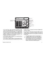
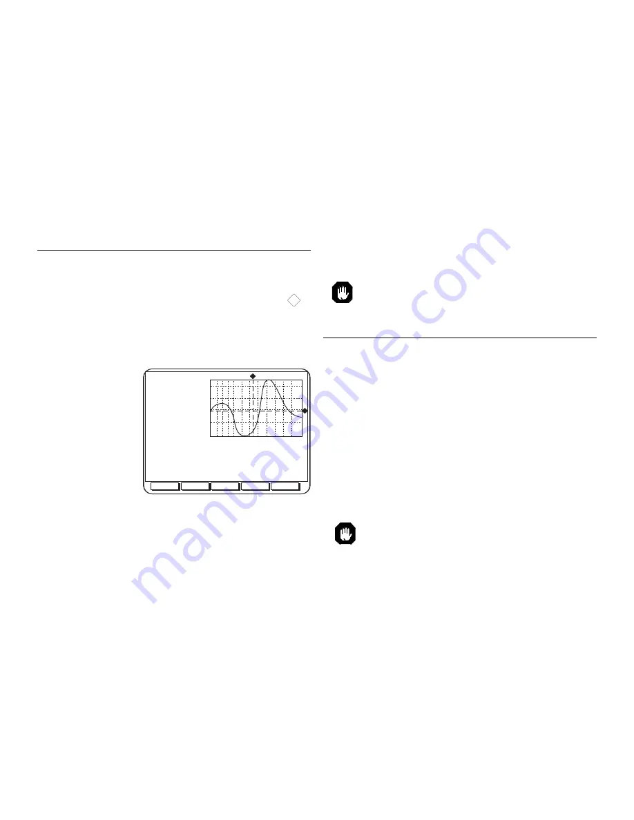
The Tide screen (shown below) will appear.
The top left of the screen shows the current time and height
according to the
tide graph. The
tide graph shows
the tidal height
range over a 24
hour period. The
CURSOR KEY
allows you to move
the dotted lines on
the graph to
change the height
accordingly. Under
PORT INFO is the Tide Reference Station name, height of
the water (max and min) and the sunrise and sunset for the
date and time you have chosen. The softkeys at the bottom
of the screen allow you to set the date. Press the desired key
SetDate
Today
NextDay
PrevDay
Time:
12:00
Height:
0.27 Ft
Aug/14/98 +1
31590.83
56167.92
Port Info
Carlo Forte
High Water (max)
0.51 Ft (17:00L)
Low Water (min)
0.18 Ft (09:00L)
Sunrise
05:54L
Sunset
18:59L
0 2 4 6 8 10 12 14 16 18 20 22 24
0.51
0.43
0.35
0.26
0.18
and the tide graph will show the tides for the appointed
day.
The C-MAP cartridge needs to be inserted into
the receiver in order to obtain the above informa-
tion.
Viewing Port Information
The receiver can show you information regarding port
services such as restaurants, fuel stations, police, etc. From
the Map screen, press
ENTER
. Press the
LOCPORT
softkey at the bottom of the Map screen to locate a port. A
screen will appear listing the local services available.
Use the
CURSOR KEY
to highlight the service you want
information about and press ENTER to find the name,
distance and bearing of the port for the service. The ports
are listed in order of nearest proximity to your present
position. Again, use the
CURSOR KEY
to highlight your
choice and press
ENTER
. A screen appears to give you
specifics on the service you have chosen. Press
ESC
to view
the Map screen with your port location selection shown.
The C-MAP cartridge containing port informa-
tion is needed for this function.
Содержание NAV 6500
Страница 1: ...NAV 6500 NAV 6510 User Manual M A G E L L A N...
Страница 3: ...Magellan NAV 6500 NAV 6510 User Manual...
Страница 8: ...Coordinate Systems 93 What Is GPS 95 Explanation of Data Terms 97 Glossary 99 Index 102...
Страница 81: ...Magellan NAV 6500 NAV 6510 73 Flush Mount Diagram...
Страница 88: ...Magellan NAV 6500 NAV 6510 80 Water Turbulence Tideway Water turbulence Weed Kelp Windmill Windmotor Wrecks...
Страница 112: ...Magellan NAV 6500 NAV 6510 104...
Страница 113: ......
Страница 114: ...630323 960 Overland Court San Dimas CA 91773 USA 909 394 5000...


