


103
User Manual
default setting is Classic.
Normal
is recommended when the chart plotter is not exposed to the direct
sunlight. When this mode is set the maps are displayed in order to use colors as similar as possible to the
ones used in the original paper charts.
Classic
uses more vivid colors.
Night Vision
is recommended
when the environment is dark in order to reduce the glare of the display. The chart plotter displays
maps and screen in darker colors.
Sunligh
t is designed to enhance the visibility of the screen when the
chart plotter is exposed to the sunlight. The maps are much brighter than in the other modes and the
depth areas are filled with white color so different depth areas are not easily distinguishable. NOAA
allows setting NOAA paper chart colors presentation.
'MENU' + "MAP SETTINGS" +'ENTER' + "Palette" + 'ENTER'
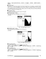
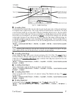
Perspective View
Chart data may be projected in perspective mode during navigation. This function allows setting the
panoramic View of the chart. As the upper side of the map is more compressed than the lower side, a
wider map area is visible. The perspective view allows showing more chart information immediately
ahead and around the cursor.
'MENU' +
"MAP SETTINGS" +'ENTER' + "Perspective View" + 'ENTER'
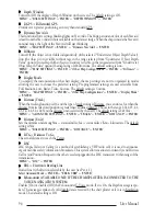
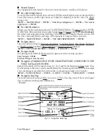
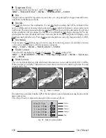
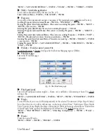
Pictures and Diagrams
The MAX data format allows assigning one or more image to any cartographic object. These
Pictures
are typically used to facilitate the identification of cartographic objects or places around the map: they
can be the landscape layout nearby a harbor, the shape of a bridge or of a buoy etc.
On some objects, such as bridges, the image associated can represent the
Diagram
representing the
shape of the objects and the various characteristics (length, height, type of bridge etc.).
Fig.5f - Pictures and Diagrams
Place Names
Turns On/Off the displaying of the Names. The default setting is On.
'MENU' + "MAP SETTINGS" +'ENTER' + "Other Map Configurations" + 'ENTER' + "Place Names" +
'ENTER'
POIs
Searches for Nearest POIs:
'MENU' + "FIND" + 'ENTER' + "POIs" + 'ENTER'
POIs
Enables or disables the displaying of POIs (Points Of Information). The default setting is On.
'MENU' + "MAP SETTINGS" +'ENTER' + "Other Map Configurations" + 'ENTER' + "POIs" + 'ENTER
Port 1/2/3/4/5 Input
Disables (selecting Off) or sets the format for the navigation data input serial Port1/2/3/4/5. For
example to set the Port as NMEA-0183 (4800 Baud Rate, Parity None, 8 Bits Number, 1 Stop Bit and
Normal Polarity) you must select 4800-N81-N. The available choice is among (1200-N81-N), NMEA
(4800-N81-N), NMEA (4800-N82-N), NMEA (9600-O81-N), NMEA (9600-N81-N), C-COM. The
default setting is (4800-N81-N).
'MENU' +
"BASIC SETTINGS" + 'ENTER' + "INPUT/OUTPUT" + 'ENTER' + "PORT 1/2/3/4/5
INPUT" + 'ENTER'
Содержание MAGNUM PLUS
Страница 8: ...10 User Manual ...
Страница 12: ...14 User Manual ...
Страница 22: ...24 User Manual ...
Страница 46: ...48 User Manual ...


