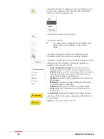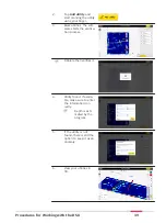
Scan
1.
Make sure to have the
grid physically marked
on the ground surface.
Refer to setup tutorial.
DSX works using grid principle relaying on
scanning the ground in both parallel lines
at 50 cm/18 in intervals in transversal
and longitudinal directions.
Minimum supported grid size is
4 × 4 m/12 × 12 ft.
Maximum supported grid size is
11 × 11 m/33 × 33 ft.
Grids can be square or rectangular. Use
measuring tapes and the grid assistance
square (in DSX accessory bag) to accu-
rate mark the grid on the ground surface.
2.
Do a site check.
Tap
Add POI
to add
conspicuous points of
interest on site.
3.
Adjust the cart position
and direction using the
arrows to coincides the
conditions on site.
4.
Place the cart centre
precisely on top of the
starting point.
☞
Use the four
red markers
in the front,
back and
sides of the
cart.
5.
Tap
Start Scan
and
start pushing the cart
forward.
6.
Precisely on top of the
end point of the line
tap
Stop Scan
to stop
the cart.
7.
Once the full scan is
ended, tap
Analyse
Data
.
Procedures for Working with the DSX
43
Содержание DSX
Страница 1: ...Leica DSX User Manual Version 1 1 English ...
Страница 51: ...6 The Home screen appears with the GNSS icon in green Procedures for Working with the DSX 51 ...
Страница 53: ...Wet connectors must be dry before attaching the dust cap Connectors with dust caps Care and Transport 53 ...
Страница 57: ......


