background image

English     

5

Map Data Information

One of the goals of Garmin is to provide customers 
with the most-complete and accurate cartography 
that is available to us at a reasonable cost. We use 
a combination of governmental and private data 
sources, which we identify in product literature and 
copyright messages displayed to the consumer. 
Virtually all data sources contain some inaccurate 
or incomplete data. In some countries, complete 
and accurate map information is either not 
available or is prohibitively expensive.

Software License Agreement

BY USING THE KNA-G620T, YOU AGREE TO BE 
BOUND BY THE TERMS AND CONDITIONS OF THE 
FOLLOWING SOFTWARE LICENSE AGREEMENT. 
PLEASE READ THIS AGREEMENT CAREFULLY.
Garmin grants you a limited license to use the 
software embedded in this device (the “Software”) 
in binary executable form in the normal operation 
of the product. Title, ownership rights, and 
intellectual property rights in and to the Software 
remain in Garmin.
You acknowledge that the Software is the property 
of Garmin and is protected under the United 
States of America copyright laws and international 
copyright treaties. You further acknowledge 
that the structure, organization, and code of the 
Software are valuable trade secrets of Garmin and 
that the Software in source code form remains a 
valuable trade secret of Garmin. You agree not to 
decompile, disassemble, modify, reverse assemble, 
reverse engineer, or reduce to human readable 
form the Software or any part thereof or create any 
derivative works based on the Software. You agree 
not to export or re-export the Software to any 
country in violation of the export control laws of 
the United States of America.

NAVTEQ

®

 End-user License Agreement

The software embedded in your Garmin product 
(the “Software”) is owned by Garmin Ltd. or its 
subsidiaries (“Garmin”). The third-party map data 
embedded in or accompanying your Garmin 
product (the “Data”) is owned by NAVTEQ North 
America LLC and is licensed to Garmin. Both the 
Software and Data are protected under copyright 
laws and international copyright treaties. The 
Software and Data are licensed, not sold. The 
Software and Data are provided under the 
following license and are subject to the following 
terms and conditions which are agreed to by End 
User (“you” or “your”), on the one hand, and Garmin 
and its licensors (including their licensors and 

suppliers) and affiliated companies on the other 
hand.

IMPORTANT

: CAREFULLY READ THIS LICENSE 

BEFORE USING THIS PRODUCT. INSTALLING, 
COPYING, OR OTHERWISE USING THIS PRODUCT 
INDICATES YOUR ACKNOWLEDGMENT THAT 
YOU HAVE READ THIS LICENSE AND AGREE TO 
ITS TERMS. IF YOU DO NOT AGREE, RETURN THE 
COMPLETE PRODUCT WITHIN 10 DAYS OF THE 
DATE YOU ACQUIRED IT (IF PURCHASED NEW) 
FOR A FULL REFUND TO ONE OF THE FOLLOWING: 
(1) THE DEALER FROM WHICH YOU PURCHASED 
THIS PRODUCT; (2) Garmin INTERNATIONAL, INC. 
CUSTOMER SERVICE, 1200 EAST 151st STREET, 
OLATHE, KS 66062, USA; (3) Garmin (EUROPE) LTD., 
LIBERTY HOUSE, HOUNSDOWN BUSINESS PARK, 
SOUTHAMPTON, SO40 9LR, UNITED KINGDOM; OR 
(4) Garmin CORPORATION CUSTOMER SERVICE, No. 
68, JANGSHU 2nd ROAD, SIJHIH, TAIPEI COUNTY, 
TAIWAN.

License Terms and Conditions

Garmin (“we” or “us”) provides you with storage 
media containing the computer Software (the 
“Software”) and the embedded or accompanying 
digital map Data, including any “online” or 
electronic documentation and printed materials 
(together called the “Product” for purposes of this 
License Agreement), and grants you a limited, 
non-exclusive license to use the Product in 
accordance with the terms of this Agreement. You 
agree to use this Data together with the Garmin 
product for solely personal, or if  applicable, for 
use in your business’ internal operations, and not 
for service bureau, time-sharing, resale or other 
similar purposes. Accordingly, but subject to the 
restrictions set forth in the following paragraphs, 
you may copy this Data only as necessary for your 
use to (i) view it, and (ii) save it, provided that you 
do not remove any copyright notices that appear 
and do not modify the Software or Data in any 
way. You agree not to otherwise reproduce, copy, 
modify, decompile, disassemble, reverse engineer 
or create derivative works of any portion of the 
Product, and may not transfer or distribute it in 
any form, for any purpose, except to the extent 
permitted by mandatory laws.

Restrictions

. Except where you have been 

specifically licensed to do so by Garmin, and 
without limiting the preceding paragraph, you may 
not use this Data with any products, systems, or 
applications installed or otherwise connected to 
or in communication with vehicles, and which are 
capable of dispatch, fleet management or similar 
applications where the Data is used by a central 
control center in dispatching a fleet of vehicles. In 
addition, you are prohibited from renting or leasing 

190-01160-90_0A.indb   5

190-01160-90_0A.indb   5

1/4/2010   9:16:12 AM

1/4/2010   9:16:12 AM

Содержание KNA-G620T

Страница 1: ...GPS NAVIGATION INSTRUCTION MANUAL MANUEL D INSTRUCTIONS DE NAVIGATION DU GPS MANUALE DI ISTRUZIONI DEL NAVIGATORE GPS MANUAL DE INSTRUCCIONES DE NAVEGACIÓN GPS MANUAL DO UTILIZADOR DO SISTEMA DE NAVEGAÇÃO GPS HANDBUCH FÜR DAS GPS NAVIGATIONSSYSTEM INSTRUCTIEHANDLEIDING GPS NAVIGATIE B64 4718 08 190 01160 90_0A indb 1 190 01160 90_0A indb 1 1 4 2010 9 16 08 AM 1 4 2010 9 16 08 AM ...

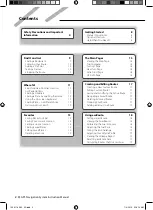
Страница 2: ...g Routes 17 Creating a New Custom Route 17 Editing Custom Routes 17 Saving and Modifying the Active Route 17 Navigating a Saved Route 17 Deleting All Saved Routes 17 Stopping Your Route 17 Adding a Detour to a Route 17 Where To 11 Searching Near Another Location 11 Go Page Options 11 Finding an Address 11 Finding a Place by Spelling the Name 12 Using the On Screen Keyboard 12 Finding Places in a D...

Страница 3: ... the Time Settings 21 Setting the Languages 21 Adding Security 21 Adjusting the Volume 21 Icons Used in This Manual Important precautions are described to prevent injuries etc Special instructions supplementary explanations limitations and reference pages are described Traffic Information 20 Understanding FM TMC Traffic 20 Traffic in Your Area 20 Traffic on Your Route 20 Viewing the Traffic Map 20...

Страница 4: ...wever and the correct position will be displayed Be careful of the ambient temperature Using the navigation system at extreme temperatures can lead to malfunction or damage Also note that the unit can be damaged by strong vibration by metal objects or by water getting inside the unit 2CAUTIONS Failure to avoid the following potentially hazardous situations may result in injury or property damage T...

Страница 5: ...their licensors and suppliers and affiliated companies on the other hand IMPORTANT CAREFULLY READ THIS LICENSE BEFORE USING THIS PRODUCT INSTALLING COPYING OR OTHERWISE USING THIS PRODUCT INDICATES YOUR ACKNOWLEDGMENT THAT YOU HAVE READ THIS LICENSE AND AGREE TO ITS TERMS IF YOU DO NOT AGREE RETURN THE COMPLETE PRODUCT WITHIN 10 DAYS OF THE DATE YOU ACQUIRED IT IF PURCHASED NEW FOR A FULL REFUND T...

Страница 6: ...DUCT OR THE DATA SHALL NOT EXCEED 1 00 Some States Territories and Countries do not allow certain liability exclusions or damages limitations so to that extent the above may not apply to you Disclaimer of Endorsement Reference to any products services processes hypertext links to third parties or other Data by trade name trademark manufacturer supplier or otherwise does not necessarily constitute ...

Страница 7: ...herewith The Traffic Service Data is informational only You assume all risk of use The Traffic Service Provider Garmin Ltd and its subsidiaries and their suppliers make no representations about content traffic and road conditions route usability or speed Garmin and its Traffic Service Provider s make no warranty of fitness or compatibility of the traffic data with the Garmin product and no warrant...

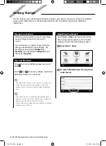
Страница 8: ...manual are intended for reference only After your KNA unit is installed and connected to your display unit press the reset button on your display unit before using the KNA unit for the first time Several screens may appear on your display unit before it recognizes your KNA unit Help When You Need It Touch Tools Help to get more information about using your navigation system Touch a category to vie...

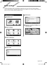
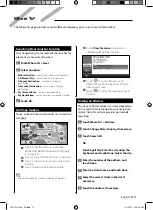
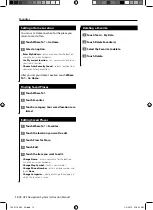
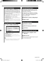
Страница 9: ...aded in your navigation system contains millions of points of interest such as restaurants hotels and auto services Finding a Restaurant 1 Touch Where To 2 Select a category 3 Select a subcategory 4 Select a type 5 Touch a place 6 Touch Go or touch Press for More to see the Review page 190 01160 90_0A indb 9 190 01160 90_0A indb 9 1 4 2010 9 16 13 AM 1 4 2010 9 16 13 AM ...

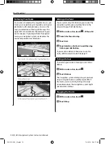
Страница 10: ...avigation system gives you directions to the stop and to your final destination 1 With a route active touch Where To 2 Search for the extra stop 3 Touch Go 4 Touch Add As a Via Point to add this stop before your destination If you want to add more than one stop to the route edit the current route See page 17 Taking a Detour If a road on your route is closed you can take a detour 1 With a route act...

Страница 11: ... to the previous page The call functionality is not available on all models Touch Press for more to view more information about the location Touch to switch between a 3D three dimensional map and a 2D two dimensional map Touch to rotate the viewing angle in 3D view Finding an Address The steps to find an address can vary depending on the maps that are loaded on your navigation system Not all map d...

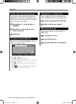
Страница 12: ... to move the cursor Touch to delete the character or touch and hold to delete the entire entry Touch to select words you have recently typed and selected Touch to change the keyboard language mode Touch to enter special characters Finding Places in a Different Area You can search for locations in a different area such as a different city or near your destination 1 From the subcategories list touch...

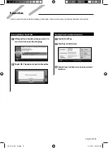
Страница 13: ...ed in Favorites Saving Your Current Location 1 Touch View Map 2 Touch vehicle icon 3 Touch Save Location to save your current location Favorites You can save all of your favorite places in Favorites You can also save your home location in Favorites 190 01160 90_0A indb 13 190 01160 90_0A indb 13 1 4 2010 9 16 20 AM 1 4 2010 9 16 20 AM ...

Страница 14: ...h Where To 2 Touch Favorites 3 Touch a category Your saved locations are listed Editing Saved Places 1 Touch Where To Favorites 2 Touch the location you want to edit 3 Touch Press for More 4 Touch Edit 5 Touch the item you want to edit Change Name enter a new name for the location using the on screen keyboard Change Map Symbol touch a new symbol Change Phone Number enter a phone number and touch D...

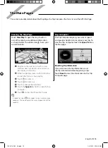
Страница 15: ... in Touch to zoom out Touch to change the data field Touch the Speed data field to open the Trip Computer Touch to view the Where Am I page A speed limit icon may appear as you travel on major roadways This icon displays the current speed limit of the roadway Trip Computer The Trip Computer displays your current speed and provides helpful statistics about your trip To view the Trip Computer touch ...

Страница 16: ...r left corner of the Map page or touch any turn on the Turn List page Lane Assist Page When available the Lane Assist page may display a view of the upcoming junction and in which lane you should be driving To view the Lane Assist page touch the upper left corner of the Map page You can also access the Lane Assist page from the Next Turn page GPS Info Page From the Nav Menu page touch in the upper...

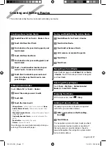
Страница 17: ...tically when you exit any of the route edit pages Saving and Modifying the Active Route 1 Touch Where To or Tools Routes 2 Touch Active Route 3 Touch Add or Remove Points 4 Add remove or reorder the points 5 Touch Next 6 Touch Save Navigating a Saved Route From the Main page touch Where To or Tools Routes Touch the route you want to navigate and touch Go Deleting All Saved Routes Touch Tools My Da...

Страница 18: ... Touch Tools ecoRoute Fuel Report To ensure that fuel data is always recorded keep your navigation system turned on while driving Calibrating the Fuel Economy Calibrate the fuel economy to receive more accurate fuel reports for your specific vehicle and driving habits Calibrate when you fill up your fuel tank 1 Calculate your miles per gallon or kilometers per liter enter information based on prom...

Страница 19: ...onomy for your vehicle Hwy Fuel Economy enter the average highway fuel economy for your vehicle For best results calibrate your fuel economy instead of adjusting the city and highway fuel economy here Viewing the Mileage Report Mileage reports provide the distance the time the average fuel economy and the fuel cost of navigating to a destination A mileage report is created for every route that you...

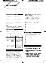
Страница 20: ...dated Traffic on Your Route When calculating your route the navigation system examines the current traffic and automatically optimizes the route for the fastest time shortest distance less fuel or off road If a severe traffic delay occurs on your route while you are navigating the navigation system automatically recalculates the route You might still be routed through traffic if no better alternat...

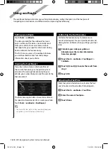
Страница 21: ...Preference select a preference for calculating your route Avoidances select the road types you want to avoid or you would prefer to use on your routes Voice Prompts turn voice prompts on or off Restore restore the original navigation settings Adjusting the Display Settings Touch Settings Display Color Mode select Day for a light background Night for a dark background or Auto to automatically switc...

Страница 22: ... site to complete the installation of the update software Updating the Map Data The navigation system will provide periodic notification at startup when the preloaded maps are considered out of date You can purchase an SD card of updated map data from Garmin or ask your Kenwood dealer or Kenwood service center for details 1 Go to www garmin com Kenwood Select Order Map Updates and follow the Web s...

Страница 23: ...der to install the POIs onto an SD card Use the SD card to load the POIs The POI Loader is available at www garmin com products poiloader Refer to the POI Loader Help file for more information click Help to open the Help file The unit may restart when you insert an SD card Each time you load custom POIs to the navigation system any other custom POIs already saved in the system will be overwritten ...

Страница 24: ... Part Number 190 01160 90 Rev A Garmin and the Garmin logo are trademarks of Garmin Ltd or its subsidiaries registered in the USA and other countries ecoRoute is a trademark of Garmin Ltd or its subsidiaries These trademarks may not be used without the express permission of Garmin NAVTEQ is a trademark of NAVTEQ Inc or its affiliates and is registered in one or more countries including the U S All...

Страница 25: ...SYSTEME DE NAVIGATION GPS KNA G620T MANUEL D INSTRUCTIONS DE NAVIGATION DU GPS B64 4718 08 190 01160 90_0A indb 1 190 01160 90_0A indb 1 1 4 2010 9 16 29 AM 1 4 2010 9 16 29 AM ...

Страница 26: ...éation d un itinéraire personnalisé 17 Modification des itinéraires personnalisés 17 Enregistrement et modification de l itinéraire actif 17 Suivi d un itinéraire enregistré 17 Suppression de tous les itinéraires enregistrés 17 Arrêt de l itinéraire 17 Ajout d un détour à l itinéraire 17 Où aller 11 Recherche à proximité d une autre position 11 Options de la page Aller 11 Recherche d une adresse 1...

Страница 27: ...age 21 Mise à jour des paramètres de l heure 21 Définition des langues 21 Ajout de paramètres de sécurité 21 Réglage du volume 21 Icônes utilisées dans ce manuel Des précautions importantes sont données pour éviter les blessures etc Des instructions spéciales des explications supplémentaires des restrictions d utilisation et des références sont fournies Informations sur le trafic 20 Présentation d...

Страница 28: ...tants les signaux satellites du GPS seront reçus et la position correcte s affichera Prenez garde à la température ambiante L utilisation du système de navigation à des températures particulièrement élevées ou basses peut entraîner des dysfonctionnements ou des dommages Le système peut également être endommagé par de fortes vibrations par des objets métalliques ou par une infiltration d eau 2MISES...

Страница 29: ...es acceptés à la fois par l Utilisateur final vous votre vos et par Garmin ses fournisseurs ainsi que leurs propres fournisseurs et revendeurs et leurs filiales IMPORTANT LISEZ CE CONTRAT ATTENTIVEMENT AVANT D UTILISER CE PRODUIT EN INSTALLANT EN COPIANT OU EN UTILISANT CE PRODUIT DE QUELQUE MANIERE QUE CE SOIT VOUS RECONNAISSEZ AVOIR LU ET ACCEPTER LES TERMES ET DISPOSITIONS DE LA PRESENTE LICENC...

Страница 30: ...D A LEURS OBLIGATIONS EN VERTU DU PRESENT CONTRAT OU AU PRODUIT ET AUX DONNEES Garmin NE DOIT PAS EXCEDER 1 Certains Etats territoires et pays n autorisent pas certaines exclusions de responsabilité ou limitations de dommages les limitations ci dessus ne vous concernent donc peut être pas Exclusion de promotion Toute référence à des produits services processus liens hypertextes vers des tierces pa...

Страница 31: ...sent Contrat Les données du service d info trafic sont fournies à titre d information uniquement Vous vous engagez à assumer tout risque lié à leur utilisation Le fournisseur de service d info trafic Garmin Ltd et ses filiales et leurs fournisseurs ne garantissent en aucun cas le contenu des données les conditions de la route et de circulation les possibilités d utilisation ou la rapidité de l iti...

Страница 32: ... présent manuel sont fournies pour référence uniquement Une fois le KNA installé et connecté au système d affichage appuyez sur le bouton Reset du système d affichage avant d utiliser le KNA pour la première fois Il est possible que plusieurs écrans s affichent sur le système d affichage avant qu il ne reconnaisse le KNA Aide 24h 24 Touchez Outils Aide pour obtenir de plus amples informations sur ...

Страница 33: ...ent des millions de points d intérêt comme des restaurants hôtels et centres auto Recherche d un restaurant 1 Touchez Où aller 2 Sélectionnez une catégorie 3 Sélectionnez une sous catégorie 4 Sélectionnez un type de restaurant 5 Touchez un lieu 6 Touchez Aller ou Appuyer pour en savoir plus pour afficher la page Review Consulter 190 01160 90_0A indb 9 190 01160 90_0A indb 9 1 4 2010 9 16 34 AM 1 4...

Страница 34: ... votre itinéraire Le système de navigation vous guide jusqu à cette étape puis jusqu à votre destination finale 1 Dans un itinéraire actif touchez Où aller 2 Recherchez l étape supplémentaire 3 Touchez Aller 4 Touchez Ajouter comme étape dans l itinéraire pour ajouter cette étape avant votre destination Pour ajouter plusieurs étapes à l itinéraire modifiez l itinéraire actuel Voir page 17 Suivi d ...

Страница 35: ...our créer un itinéraire détaillé jusqu à cette position Touchez pour revenir à la page précédente La fonction d appel n est pas disponible sur tous les modèles Touchez Appuyer pour en savoir plus pour afficher d autres informations sur la position Touchez pour basculer entre une carte 3D en trois dimensions et une carte 2D en deux dimensions Touchez pour faire pivoter l angle de vue de l affichage...

Страница 36: ...z pour supprimer le caractère touchez et maintenez votre pression pour supprimer complètement l entrée Touchez pour sélectionner des mots récemment saisis et sélectionnés Touchez pour modifier la langue du clavier Touchez pour saisir des caractères spéciaux Recherche de lieux dans une autre zone Vous pouvez rechercher des emplacements dans une zone différente telle qu une autre ville ou les enviro...

Страница 37: ... Enregistrement de votre position actuelle 1 Touchez Afficher carte 2 Touchez icône du véhicule 3 Touchez Enregistrer la position pour enregistrer votre position actuelle Favoris Vous pouvez enregistrer tous vos lieux favoris dans Favoris Vous pouvez également enregistrer votre position d origine dans Favoris 190 01160 90_0A indb 13 190 01160 90_0A indb 13 1 4 2010 9 16 45 AM 1 4 2010 9 16 45 AM ...

Страница 38: ... Touchez Favoris 3 Touchez une catégorie Vos lieux enregistrés sont répertoriés Modification de lieux enregistrés 1 Touchez Où aller Favoris 2 Touchez la position à modifier 3 Touchez Appuyer pour en savoir plus 4 Touchez Modifier 5 Touchez l élément à modifier Modifier nom saisissez un nouveau nom pour la position à l aide du clavier virtuel Modifier le symbole cartographique touchez un nouveau s...

Страница 39: ... Touchez pour effectuer un zoom arrière Touchez pour modifier le champ de données Touchez le champ de données Vitesse pour ouvrir le calculateur de voyage Touchez pour afficher la page Où suis je Une icône de limite de vitesse s affiche lorsque vous roulez sur les routes principales Cette icône indique la limite de vitesse à respecter sur la route que vous empruntez Calculateur de voyage Le calcul...

Страница 40: ...ur la carte touchez le coin supérieur gauche de la page Carte ou n importe quel changement de direction dans la liste des changements de direction Page Assistant de voies de circulation Le cas échéant la page Assistant de voies de circulation peut afficher la prochaine intersection et vous indiquer la voie sur laquelle vous devez vous insérer Pour afficher la page Assistant de voies de circulation...

Страница 41: ...Vos modifications sont enregistrées automatiquement lorsque vous quittez l une des pages de modification de l itinéraire Enregistrement et modification de l itinéraire actif 1 Touchez Où aller ou Outils Itinéraires 2 Touchez Itinéraire actif 3 Touchez Ajouter ou supprimer des points 4 Ajoutez supprimez ou réorganisez les points 5 Touchez Suivant 6 Touchez Enregistrer Suivi d un itinéraire enregist...

Страница 42: ... assurer que les données de carburant sont toujours enregistrées gardez votre système de navigation allumé lorsque vous conduisez Ajustement de la consommation Ajustez votre consommation de carburant pour recevoir des rapports de carburant plus précis tenant compte de votre véhicule et de vos habitudes de conduite Procédez à l ajustement lorsque vous faites le plein de carburant 1 Calculez le nomb...

Страница 43: ...on urbaine moyenne de votre véhicule Consommation extra urbaine saisissez la consommation extra urbaine moyenne de votre véhicule Pour de meilleurs résultats ajustez votre consommation au lieu de régler la consommation urbaine et extra urbaine Affichage du rapport kilométrique Le rapport kilométrique indique la distance la durée la consommation moyenne et le prix du carburant jusqu à votre destina...

Страница 44: ... l itinéraire le système de navigation prend en compte les conditions de circulation actuelles et optimise automatiquement l itinéraire pour qu il soit le plus rapide le plus court le plus économique possible ou tout terrain En cas de problème de circulation important lors du suivi d un itinéraire le système de navigation recalcule automatiquement l itinéraire L encombrement ne sera pas nécessaire...

Страница 45: ...n Préférences d itinéraire sélectionnez la méthode de calcul d itinéraire que vous préférez Contournements sélectionnez les types de routes à éviter ou que vous préférez prendre dans vos itinéraires Instructions vocales activez ou désactivez les instructions vocales Restaurer restaurez les paramètres de navigation d origine Réglage des paramètres d affichage Touchez Paramètres Affichage Mode Coule...

Страница 46: ...ion du logiciel mis à jour Mise à jour des données cartographiques De temps à autre au démarrage le système de navigation vous indique que les cartes préchargées sont obsolètes Vous pouvez acheter auprès de Garmin une carte SD des données cartographiques mises à jour ou demander plus d informations à votre revendeur Kenwood ou au centre d assistance Kenwood 1 Accédez au site www garmin com Kenwood...

Страница 47: ... carte SD pour charger les points d intérêt personnalisés POI Loader est disponible à l adresse suivante www garmin com products poiloader Pour plus d informations reportez vous au fichier d aide de POI Loader Cliquez sur Help Aide pour ouvrir le fichier d aide Il se peut que l appareil redémarre lorsque vous insérez une carte SD A chaque fois que vous chargez des points d intérêt personnalisés da...

Страница 48: ... www garmin com Numéro de référence 190 01160 90 Rév A Garmin et le logo Garmin sont des marques commerciales de Garmin Ltd ou de ses filiales déposées aux Etats Unis d Amérique et dans d autres pays ecoRoute est une marque commerciale de Garmin Ltd ou de ses filiales Elles ne peuvent être utilisées sans l autorisation expresse de Garmin NAVTEQ est une marque commerciale de NAVTEQ Inc ou de ses fi...

Страница 49: ...SISTEMA DI NAVIGAZIONE GPS KNA G620T MANUALE DI ISTRUZIONI DEL NAVIGATORE GPS B64 4718 08 190 01160 90_0A indb 1 190 01160 90_0A indb 1 1 4 2010 9 16 58 AM 1 4 2010 9 16 58 AM ...

Страница 50: ...e 14 Creazione e modifica dei percorsi 17 Creazione di un nuovo percorso personalizzato 17 Modifica dei percorsi personalizzati 17 Salvataggio e modifica del percorso attivo 17 Navigazione di un percorso salvato 17 Eliminazione di tutte le rotte salvate 17 Interruzione del percorso 17 Aggiunta di una deviazione al percorso 17 Dove si va 11 Ricerca di località vicine 11 Opzioni della pagina Vai 11 ...

Страница 51: ...21 Aggiornamento delle impostazioni dell ora 21 Impostazione delle lingue 21 Maggiore sicurezza 21 Regolazione del volume 21 Icone utilizzate nel presente manuale Le precauzioni importanti vengono descritte per evitare lesioni alle persone ecc Vengono inoltre descritte istruzioni speciali ulteriori spiegazioni limitazioni e pagine di riferimento Informazioni sul traffico 20 Informazioni sul traffi...

Страница 52: ...e alla temperatura dell ambiente Utilizzare il sistema di navigazione a temperature estreme può provocare anomalie o danni Inoltre l unità può essere danneggiata da vibrazioni eccessive o dal contatto con oggetti metallici o acqua 2ATTENZIONE La mancata osservanza dei suggerimenti forniti di seguito potrebbe causare danni a cose e persone Il sistema di navigazione è stato progettato per fornire un...

Страница 53: ...ori e le società affiliate dall altra IMPORTANTE LEGGERE ATTENTAMENTE LA PRESENTE LICENZA PRIMA DELL UTILIZZO CON L INSTALLAZIONE LA COPIA O QUALSIASI ALTRO UTILIZZO DI QUESTO PRODOTTO L UTENTE DICHIARA DI AVER LETTO E COMPRESO QUANTO RIPORTATO NELLA PRESENTE LICENZA E DI ACCETTARNE I TERMINI IN CASO DI NON ACCETTAZIONE DELLA SUDDETTA LICENZA RESTITUIRE IL PRODOTTO INTEGRO ENTRO 10 GIORNI DALLA DA...

Страница 54: ...ICENZIATARI PER QUANTO CONCERNE GLI OBBLIGHI PREVISTI DAL PRESENTE CONTRATTO O IN ALTRO MODO CORRELATI AL PRODOTTO Garmin O AI DATI NON DEVE SUPERARE L IMPORTO MASSIMO DI 1 00 Alcune giurisdizioni territori e paesi non riconoscono determinate esclusioni di responsabilità o limitazioni ai danni pertanto la suddetta esclusione potrebbe non applicarsi al caso specifico Esclusione di impegno Qualsiasi...

Страница 55: ...vengono diffusi esclusivamente a titolo informativo L utente si assume tutti i rischi connessi al loro utilizzo Il Fornitore di servizi di infotraffico Garmin Ltd e le relative affiliate e i relativi fornitori non forniscono alcuna garanzia in merito ai contenuti alle informazioni sulle condizioni del traffico e delle strade alla percorribilità dei percorsi o alla velocità Garmin e i relativi Forn...

Страница 56: ...ale sono utilizzate solo per riferimento Dopo aver installato l unità KNA e averla collegata all unità del display premere il pulsante Reset sull unità del display prima di usare l unità KNA per la prima volta Sull unità del display potrebbero essere visualizzate più schermate prima che venga riconosciuta l unità KNA Supporto immediato Toccare Strumenti Aiuto per maggiori informazioni sull uso del...

Страница 57: ...a di navigazione contiene milioni di punti di interesse ad esempio ristoranti alberghi e stazioni di servizio Ricerca di un ristorante 1 Toccare Dove si va 2 Selezionare una categoria 3 Selezionare una sottocategoria 4 Selezionare un tipo 5 Toccare una località 6 Toccare Vai o Maggiori informazioni per aprire la pagina di revisione 190 01160 90_0A indb 9 190 01160 90_0A indb 9 1 4 2010 9 17 03 AM ...

Страница 58: ...oni per raggiungere prima il punto desiderato per la sosta quindi la destinazione finale 1 Con un percorso attivo toccare Dove si va 2 Individuare la sosta da aggiungere 3 Toccare Vai 4 Toccare Aggiungi come punto intermedio per aggiungere la sosta prima della destinazione Per aggiungere più soste modificare il percorso attivo Vedere a pagina 17 Come effettuare una deviazione Se una strada lungo i...

Страница 59: ...reare un percorso con indicazione delle svolte fino alla posizione desiderata Toccare per tornare alla pagina precedente La funzionalità di chiamata non è disponibile in tutti i modelli Toccare Maggiori informazioni per visualizzare ulteriori informazioni sulla posizione Toccare per passare da una mappa 3D tridimensionale a una mappa 2D bidimensionale e viceversa Toccare per ruotare l angolazione ...

Страница 60: ... uno spazio Toccare e per spostare il cursore Toccare per eliminare l ultimo carattere inserito o tenere premuto per eliminare l intera voce Toccare per selezionare le parole digitate in precedenza Toccare per modificare il modo della lingua della tastiera Toccare per inserire i caratteri speciali Ricerca di località in un area differente È possibile cercare le posizioni in un area differente ad e...

Страница 61: ...sizioni Salvataggio della posizione corrente 1 Toccare Mappa 2 Toccare icona del veicolo 3 Toccare Salva posizione per salvare la posizione corrente Mie Posizioni È possibile salvare le località preferite in Mie Posizioni È anche possibile salvare la posizione della propria casa in Mie Posizioni 190 01160 90_0A indb 13 190 01160 90_0A indb 13 1 4 2010 9 17 17 AM 1 4 2010 9 17 17 AM ...

Страница 62: ...a Viene visualizzato un elenco delle posizioni salvate Modifica delle località salvate 1 Toccare Dove si va Mie Posizioni 2 Toccare la posizione che si desidera modificare 3 Toccare Maggiori informazioni 4 Toccare Modifica 5 Toccare la voce che si desidera modificare Cambia Nome Consente di inserire un nuovo nome per la posizione mediante la tastiera visualizzata sullo schermo Cambia simbolo mappa...

Страница 63: ...occare per ingrandire l immagine Toccare per ridurre l immagine Toccare per modificare il campo dati Toccare il campo dati Velocità per aprire il computer di viaggio Toccare per visualizzare la pagina Dove mi trovo Quando si percorrono strade principali potrebbe essere visualizzata un icona di limite di velocità che indica il limite di velocità corrente Computer di viaggio Il computer di viaggio i...

Страница 64: ...e sinistro della pagina Mappa oppure toccare una svolta qualsiasi nella pagina Elenco svolte Pagina Indicatore di corsia Quando è disponibile la pagina Indicatore di corsia indica i prossimi incroci e in quale corsia si deve guidare Per visualizzare la pagina Indicatore di corsia toccare l angolo superiore sinistro della pagina Mappa È anche possibile accedere alla pagina Indicatore di corsia dall...

Страница 65: ...che vengono salvate automaticamente quando si esce dalle pagine di modifica dei percorsi Salvataggio e modifica del percorso attivo 1 Toccare Dove si va o Strumenti Percorsi 2 Toccare Percorso attivo 3 Toccare Aggiungi o rimuovi punti 4 Aggiungere o rimuovere punti o modificarne l ordine 5 Toccare Avanti 6 Toccare Salva Navigazione di un percorso salvato Nella pagina principale toccare Dove si va ...

Страница 66: ...consumi Per assicurarsi che i dati sul carburante vengano sempre registrati tenere acceso il sistema di navigazione durante la guida Calibrazione dei consumi Eseguire una calibrazione dei consumi per ricevere report più accurati specifici per le abitudini di guida e il veicolo in uso Eseguire la calibrazione a serbatoio pieno 1 Calcolare le miglia per gallone o i chilometri per litro immettere le ...

Страница 67: ...re il consumo urbano medio del veicolo Consumo extraurbano Consente di immettere il rendimento medio del consumo extraurbano del veicolo Per ottenere risultati ottimali calibrare i consumi anziché regolare il rendimento dei consumi urbano ed extraurbano Visualizzazione del report dei percorsi effettuati I report dei percorsi effettuati forniscono la distanza il tempo i consumi medi e il costo del ...

Страница 68: ...o aggiornati Eventi relativi al traffico sul proprio percorso Durante il calcolo del percorso il sistema di navigazione analizza la situazione del traffico corrente e ottimizza automaticamente il percorso per minor tempo distanza più breve percorso più economico o linea retta Se durante la navigazione si verifica un rallentamento dovuto al traffico il sistema di navigazione ricalcola automaticamen...

Страница 69: ... strade che si desidera evitare o percorrere per i propri percorsi Indicazioni vocali Consente di attivare o disattivare i comandi vocali Reimposta Consente di ripristinare le impostazioni di navigazione iniziali Regolazione delle impostazioni di visualizzazione Toccare Impostazioni Schermo Modo colore Consente di selezionare Giorno per uno sfondo luminoso Notte per uno sfondo scuro o Auto per pas...

Страница 70: ...per completare l installazione del software di aggiornamento Aggiornamento dei dati della mappa Il sistema di navigazione invierà notifiche periodiche all avvio nel caso in cui le mappe precaricate vadano aggiornate È possibile acquistare una scheda SD con dati mappa aggiornati direttamente da Garmin Altrimenti per ulteriori informazioni rivolgersi al rivenditore Kenwood o al centro di assistenza ...

Страница 71: ...rogramma POI Loader è disponibile all indirizzo www garmin com products poiloader Per ulteriori informazioni fare riferimento al file di Aiuto di POI Loader per aprire il file della guida fare clic sul relativo pulsante Quando si inserisce una scheda SD l unità potrebbe riavviarsi Ogni volta che si caricano POI personali sul sistema di navigazione gli altri POI personali salvati sul sistema vengon...

Страница 72: ...w garmin com Codice prodotto 190 01160 90 Rev A Garmin e il logo Garmin sono marchi di Garmin Ltd o società affiliate registrati negli Stati Uniti e in altri Paesi ecoRoute è un marchio di Garmin Ltd o società affiliate L uso di tali marchi non è consentito senza consenso esplicito da parte di Garmin NAVTEQ è un marchio di NAVTEQ Inc o delle società affiliate ed è registrato in uno o più paesi inc...

Страница 73: ...SISTEMA DE NAVEGACIÓN GPS KNA G620T MANUAL DE INSTRUCCIONES DE NAVEGACIÓN GPS B64 4718 08 190 01160 90_0A indb 1 190 01160 90_0A indb 1 1 4 2010 9 17 29 AM 1 4 2010 9 17 29 AM ...

Страница 74: ...ción de rutas 17 Creación de una nueva ruta personalizada 17 Edición de rutas personalizadas 17 Almacenamiento y modificación de la ruta activa 17 Navegación por una ruta guardada 17 Eliminación de todas las rutas guardadas 17 Detención de la ruta 17 Añadir un desvío a una ruta 17 Destino 11 Búsqueda cerca de otra ubicación 11 Opciones de la página Ir 11 Búsqueda de direcciones 11 Búsqueda de un l...

Страница 75: ... Ajuste de la configuración de la pantalla 21 Actualización de la configuración de la hora 21 Configuración de los idiomas 21 Añadir seguridad 21 Ajuste del volumen 21 Iconos utilizados en este manual Se describen precauciones importantes para evitar lesiones etc Se describen instrucciones especiales explicaciones adicionales limitaciones y páginas de referencia Información sobre el tráfico 20 Ace...

Страница 76: ... y se mostrará la posición correcta Ten cuidado con la temperatura ambiental Utilizar el sistema de navegación con temperaturas extremas puede dar lugar a un funcionamiento incorrecto o provocar daños Ten también en cuenta que la unidad puede dañarse con vibraciones intensas objetos metálicos o filtraciones de agua 2PRECAUCIONES No evitar las siguientes situaciones de riesgo potencial puede provoc...

Страница 77: ...edores así como sus filiales de la otra IMPORTANTE EL USUARIO DEBERÁ LEER DETENIDAMENTE ESTE ACUERDO DE LICENCIA ANTES DE USAR EL PRODUCTO LA INSTALACIÓN COPIA O USO DE ESTE PRODUCTO INDICA LA CONFIRMACIÓN DE QUE EL USUARIO HA LEÍDO ESTE ACUERDO Y ACEPTA SUS TÉRMINOS SI NO ESTUVIERA DE ACUERDO DEVUELVA TODO EL PRODUCTO PARA OBTENER EL REEMBOLSO COMPLETO EN LOS DIEZ 10 DÍAS POSTERIORES A LA FECHA D...

Страница 78: ... CON EL PRODUCTO DE Garmin O LOS DATOS NO SUPERARÁ LA CANTIDAD DE 1 00 Algunos estados territorios y países no permiten ciertas exenciones de responsabilidad o limitaciones de daños por lo que es posible que la exención anterior no sea de aplicación para el usuario Renuncia de promoción Toda referencia a produc tos servicios procesos hipervínculos a terceros u otros Datos mediante nombre comercial...

Страница 79: ...ividad no autorizada o ilegal realizada en relación con cualquiera de los aspectos mencionados Los Datos del servicio de tráfico son meramente informativos El usuario acepta todos los riesgos derivados del uso El Proveedor de servicios de tráfico Garmin Ltd y sus subsidiarias y los proveedores de ambos no son responsables del contenido las condiciones del tráfico y la carretera la utilización de l...

Страница 80: ... usadas en este manual se ofrecen sólo como referencia Una vez que la unidad KNA esté instalada y conectada a la unidad de visualización pulsa el botón Reset de la unidad de visualización antes de usar la unidad KNA por primera vez Pueden aparecer varias pantallas en la unidad de visualización antes de que reconozca la unidad KNA Ayuda cuando la necesites Toca Utilidades Ayuda para obtener más inf...

Страница 81: ...egación contiene millones de puntos de interés como por ejemplo restaurantes hoteles y servicios para automóviles Búsqueda de restaurantes 1 Toca Destino 2 Selecciona una categoría 3 Selecciona una subcategoría 4 Selecciona un tipo 5 Toca un lugar 6 Toca Ir o Pulsa para más información para ver la página de revisión 190 01160 90_0A indb 9 190 01160 90_0A indb 9 1 4 2010 9 17 35 AM 1 4 2010 9 17 35...

Страница 82: ...e navegación te da instrucciones para llegar al punto de parada y a continuación al destino final 1 Con una ruta activa toca Destino 2 Busca la parada adicional 3 Toca Ir 4 Toca Añadir como Punto de vía para añadir esta parada antes del destino Si deseas añadir más de una parada a la ruta edita la ruta actual Consulta la página 17 Tomar un desvío Si la carretera de la ruta está cortada podrás toma...

Страница 83: ... función de llamada no está disponible en todos los modelos Toca Pulsa para más información para ver más información sobre la ubicación Toca para cambiar de un mapa en 3D tres dimensiones a uno en 2D dos dimensiones Toca para girar el ángulo de visión en la vista 3D Búsqueda de direcciones Los pasos para buscar una dirección pueden variar según los mapas cargados en el sistema de navegación La opc...

Страница 84: ...r el cursor Toca para borrar el carácter o mantenlo pulsado para borrar toda la entrada Toca para seleccionar palabras que hayas escrito y seleccionado recientemente Toca para cambiar el modo de idioma del teclado Toca para introducir caracteres especiales Búsqueda de lugares en un área distinta Puedes buscar ubicaciones en áreas distintas como una ciudad diferente o cerca de tu destino 1 En la li...

Страница 85: ...rá en Favoritos Almacenamiento de la ubicación actual 1 Toca Ver mapa 2 Toca icono de vehículo 3 Toca Guardar ubicación para guardar la ubicación actual Favoritos Puedes guardar todos tus lugares favoritos en Favoritos También puedes guardar la ubicación de inicio en Favoritos 190 01160 90_0A indb 13 190 01160 90_0A indb 13 1 4 2010 9 17 49 AM 1 4 2010 9 17 49 AM ...

Страница 86: ...res guardados 1 Toca Destino 2 Toca Favoritos 3 Toca una categoría Se muestran las ubicaciones guardadas Edición de lugares guardados 1 Toca Destino Favoritos 2 Toca la ubicación que desees editar 3 Toca Pulsa para más información 4 Toca Editar 5 Toca el elemento que desees editar Cambiar nombre introduce un nuevo nombre para la ubicación usando el teclado en pantalla Cambiar símbolo de mapa toca ...

Страница 87: ...para alejar la imagen Toca para cambiar los campos de datos Toca el campo de datos Velocidad para abrir la página Procesador de trayecto Toca para ver la página Dónde estoy Si viajas por carreteras principales puede aparecer un icono de límite de velocidad Este icono indica el límite de velocidad actual que se aplica a la carretera Procesador de trayecto El procesador de trayecto indica la velocid...

Страница 88: ...a o cualquier giro de la página Lista de giros Página Indicación de carriles La página Indicación de carriles puede mostrar una vista de los próximos cruces y en qué carril debes situarte cuando esté disponible Para ver la página Indicación de carriles toca en la esquina superior izquierda de la página Mapa También puedes acceder a la página Indicación de carriles desde la página Siguiente giro Pá...

Страница 89: ...al salir de cualquiera de las páginas de edición de la ruta Almacenamiento y modificación de la ruta activa 1 Toca Destino o Utilidades Rutas 2 Toca Ruta activa 3 Toca Añadir o borrar puntos 4 Añade borra o reordena los puntos 5 Toca Siguiente 6 Toca Guardar Navegación por una ruta guardada En la página principal toca Destino o Utilidades Rutas Toca la ruta que desees seguir y toca Ir Eliminación ...

Страница 90: ...tizar que siempre se registren los datos de combustible mantén encendido el sistema de navegación mientras conduces Calibración del consumo económico Calibra el consumo económico para recibir informes sobre combustible más precisos para tu vehículo y tus hábitos de conducción específicos Realiza la calibración cuando llenes el depósito de combustible 1 Calcula las millas por galón o los kilómetros...

Страница 91: ...ico en carretera introduce el consumo económico medio en carretera del vehículo Para obtener los mejores resultados calibra el consumo económico en lugar de ajustar el consumo económico en ciudad y en carretera en este paso Visualización del informe sobre kilometraje Los informes sobre kilometraje proporcionan la distancia el tiempo el consumo económico medio y el coste del combustible necesarios ...

Страница 92: ...áfico en la ruta Al calcular la ruta el sistema de navegación examina el tráfico actual y optimiza automáticamente la ruta para vía rápida distancia más corta menos combustible o fuera de carretera Si se producen retenciones de tráfico importantes en la ruta mientras te desplazas por ella el sistema de navegación recalcula la ruta de forma automática Es posible que la unidad siga dirigiéndote a tr...

Страница 93: ...referencia de ruta selecciona una preferencia para calcular la ruta Elementos a evitar selecciona los tipos de carretera que desees evitar o que prefieras utilizar en tus rutas Indicaciones de voz activa o desactiva las indicaciones de voz Restablecer restaura la configuración original de navegación Ajuste de la configuración de la pantalla Toca Configuración Pantalla Modo de color selecciona Día ...

Страница 94: ...stalación del software de actualización Actualización de la cartografía El sistema de navegación proporcionará notificaciones periódicas al iniciarse cuando se considere que los mapas previamente cargados están obsoletos Puedes adquirir en Garmin una tarjeta SD con cartografía actualizada o consultar los detalles en tu distribuidor o centro de servicio Kenwood 1 Visita www garmin com Kenwood Selec...

Страница 95: ...arlos en la tarjeta SD Utiliza la tarjeta SD para cargar los POI El programa POI Loader está disponible en www garmin com products poiloader Consulta el archivo de ayuda de POI Loader para obtener más información haz clic en Ayuda para abrir dicho archivo Puede que la unidad se reinicie cuando introduzcas una tarjeta SD Cada vez que cargues POI personalizados en el sistema de navegación se sobresc...

Страница 96: ...ero de publicación 190 01160 90 Rev A Garmin y el logotipo de Garmin son marcas comerciales de Garmin Ltd o sus subsidiarias registradas en Estados Unidos y otros países ecoRoute es una marca comercial de Garmin Ltd o sus subsidiarias Estas marcas comerciales no se podrán utilizar sin autorización expresa de Garmin NAVTEQ es una marca comercial de NAVTEQ Inc o sus filiales y está registrada en uno...

Страница 97: ...SISTEMA DE NAVEGAÇÃO GPS KNA G620T MANUAL DO UTILIZADOR DO SISTEMA DE NAVEGAÇÃO GPS B64 4718 08 190 01160 90_0A indb 1 190 01160 90_0A indb 1 1 4 2010 9 18 02 AM 1 4 2010 9 18 02 AM ...

Страница 98: ...orito 14 Criar e editar rotas 17 Criar uma Nova Rota Personalizada 17 Editar rotas personalizadas 17 Guardar e modificar a rota activa 17 Navegar uma Rota Guardada 17 Eliminar todas as rotas guardadas 17 Parar a sua rota 17 Adicionar um desvio a uma rota 17 Para Onde 11 Procurar perto de outra posição 11 Siga Opções de página 11 Encontrar um endereço 11 Encontrar um local introduzindo o nome 12 Ut...

Страница 99: ...o ecrã 21 Actualizar as definições de hora 21 Configurar os idiomas 21 Adicionar definições de segurança 21 Ajustar o volume 21 Ícones usados neste manual As precauções importantes são descritas de modo a evitar ferimentos etc Descrevem se instruções especiais explicações suplementares limitações e páginas de referência Informações de trânsito 20 Entender os receptores FM de tráfego TMC 20 Trânsit...

Страница 100: ... temperatura ambiente A utilização do sistema de navegação em temperaturas extremas pode causar avaria ou danos Note ainda que a unidade pode ser danificada por vibrações fortes objectos metálicos ou entrada de água no seu interior 2PRECAUÇÕES Não evitar as seguintes situações potencialmente perigosas pode resultar em ferimentos ou danos materiais O sistema de navegação para lhe dar sugestões de r...

Страница 101: ... do Utilizador Final e por outro da Garmin dos seus licenciantes incluindo os respectivos licenciantes e fornecedores e empresas afiliadas IMPORTANTE LEIA ESTA LICENÇA COM ATENÇÃO ANTES DE UTILIZAR O PRODUTO A INSTALAÇÃO CÓPIA OU QUALQUER OUTRA UTILIZAÇÃO DADA A ESTE PRODUTO INDICARÃO QUE LEU E ACEITOU A LICENÇA E OS RESPECTIVOS SEUS TERMOS SE O UTILIZADOR NÃO CONCORDA COM ESTA LICENÇA DEVERÁ DEVO...

Страница 102: ...TE ACORDO NÃO EXCEDERÁ 1 00 Alguns Estados Territórios e Países não permitem determinadas exclusões de responsabilidade ou limitações de danos e por conseguinte a exclusão acima apresentada pode não abranger o utilizador Declinação de Concordância Quaisquer referências a produtos serviços processos ligações de hipertexto a terceiros ou outros Dados pelo nome da marca marca registada fabricante for...

Страница 103: ...actividades ilegais ou não autorizadas doravante levadas a cabo pelo utilizador Os dados de serviços de trânsito destinam se apenas a fins informativos O utilizador assume todos os riscos provenientes da sua utilização O Fornecedor de Serviços de Trânsito a Garmin Ltd e suas subsidiárias e respectivos fornecedores não assumem quaisquer responsabilidades relativas ao conteúdo condições de tráfego o...

Страница 104: ...servem apenas de referência Depois de a unidade KNA estar instalada e ligada ao seu monitor prima o botão reset reiniciar no monitor antes de utilizar a unidade KNA pela primeira vez Podem aparecer vários ecrãs no seu monitor antes que este reconheça a sua unidade KNA Ajuda sempre ao seu dispor Toque em Ferramentas Ajuda para obter mais informações sobre a utilização do seu sistema de navegação To...

Страница 105: ...de navegação contém milhões de pontos de interesse como restaurantes hotéis e serviços para automóveis Encontrar um restaurante 1 Toque em Para onde 2 Seleccione uma categoria 3 Seleccione uma sub categoria 4 Seleccione um tipo 5 Toque num local 6 Toque em Siga ou toque em Mais para aceder à Página de análise 190 01160 90_0A indb 9 190 01160 90_0A indb 9 1 4 2010 9 18 08 AM 1 4 2010 9 18 08 AM ...

Страница 106: ... O sistema de navegação indica lhe as direcções a seguir até à paragem e até ao destino final 1 Com uma rota activa toque em Para onde 2 Procure uma paragem adicional 3 Toque em Ir 4 Toque em Adicionar como Ponto de percurso para adicionar esta paragem antes do destino Se pretender adicionar mais do que uma paragem à rota edite a rota actual Consulte a página 17 Fazer um desvio Se uma estrada na s...

Страница 107: ...terior A funcionalidade de chamada não se encontra disponível em todos os modelos Toque em Mais para ver mais informações acerca do local Toque em para alternar entre um mapa em 3D três dimensões ou em 2D duas dimensões Toque em para girar o ângulo de vista a 3D Encontrar um endereço Os procedimentos para encontrar um endereço dependem dos mapas carregados no seu sistema de navegação Nem todos os ...

Страница 108: ...minar o caracter ou toque e mantenha sob pressão para eliminar tudo o que introduziu Toque em para seleccionar palavras introduzidas e seleccionadas recentemente Toque em para alterar o modo de idioma do teclado Toque em para introduzir caracteres especiais Encontrar locais numa área diferente Poderá procurar locais numa área diferente tal como uma cidade diferente ou um local perto do seu destino...

Страница 109: ...dado nos Favoritos Guardar a sua posição actual 1 Toque em Ver Mapa 2 Toque em ícone do veículo 3 Toque em Guardar Local para guardar a sua posição actual Favoritos Pode guardar todos os seus locais favoritos em Favoritos Pode ainda guardar a posição casa em Favoritos 190 01160 90_0A indb 13 190 01160 90_0A indb 13 1 4 2010 9 18 19 AM 1 4 2010 9 18 19 AM ...

Страница 110: ...Toque em Para onde 2 Toque em Favoritos 3 Toque numa categoria São apresentados os locais guardados Editar locais guardados 1 Toque em Para onde Favoritos 2 Toque na localização que pretende editar 3 Toque em Mais 4 Toque em Editar 5 Toque no item que deseja editar Alterar Nome introduzir um novo nome para a localização utilizando o teclado no ecrã Alterar Símbolo do Mapa toque num novo símbolo Al...

Страница 111: ...6 Toque em para aumentar o zoom Toque em para diminuir o zoom Toque para alterar o campo de dados Toque no campo de dados Velocidade para abrir o Computador de Viagem Toque para ver a página Poderá surgir um ícone de limite de velocidade ao viajar nas principais estradas Este ícone indica o limite de velocidade actual da estrada Computador de Viagem O Computador de Viagem assinala a sua velocidade...

Страница 112: ...urva na página Lista de Curvas Página de Indicação da faixa de rodagem Quando disponível a página Indicação da faixa de rodagem poderá apresentar o cruzamento seguinte e indicar lhe a faixa onde deverá encontrar se Para ver a página Indicação da faixa de rodagem toque no canto superior esquerdo da página de Mapa Pode também aceder à página de Indicação da faixa de rodagem através da página Próxima...

Страница 113: ...rdadas automaticamente ao sair de uma das páginas de edição de rota Guardar e modificar a rota activa 1 Toque em Para onde ou Ferramentas Rotas 2 Toque em Rota Activa 3 Toque em Adicionar ou remover pontos 4 Adicionar remover ou reordenar os pontos 5 Toque em Seguinte 6 Toque em Guardar Navegar uma Rota Guardada Na partir da página Principal toque em Para onde ou Ferramentas Rotas Seleccione a rot...

Страница 114: ...que os dados de combustível ficam sempre registados mantenha o sistema de navegação ligado durante a condução Calibrar a economia de combustível Calibre a economia de combustível para receber registos de combustível mais fidedignos para o seu veículo e hábitos de condução específicos Calibre quando encher o depósito de combustível 1 Calcule as milhas por galão ou quilómetros por litro introduza as...

Страница 115: ... combustível em auto estrada introduza a economia de combustível média do seu veículo em auto estrada Para obter melhores resultados calibre aqui a sua economia de combustível em vez de ajustar a economia de combustível em cidade e em auto estrada Ver o registo de quilómetros O registo de quilómetros identifica a distância o tempo a economia de combustível média e o custo de combustível do percurs...

Страница 116: ... o cálculo da rota o sistema de navegação examina o trânsito actual e optimiza a rota automaticamente de acordo com o tempo mais rápido a distância mais curta o menor consumo de combustível ou fora da estrada Se ocorrer um atraso significativo no tráfego enquanto está a navegar o sistema de navegação volta a calcular automaticamente a rota Poderá ainda ser conduzido através do trânsito se não exis...

Страница 117: ...nições de navegação Tocar em Definições Navegação Preferência de Rota toque numa preferência de cálculo da rota Elementos a evitar seleccione os tipos de estrada a evitar ou incluir nas suas rotas Indicações por Voz liga ou desliga as indicações por voz Restaurar restaura as definições de navegação originais Mudar as definições do ecrã Toque em Definições Visualização Modo de Cores seleccione Diur...

Страница 118: ...cluir a instalação do software actualizado Actualizar os dados do mapa O sistema de navegação irá fornecer notificações periódicas no início quando os mapas pré carregados são considerados desactualizados Pode adquirir um cartão SD com dados do mapa actualizados da Garmin ou obter mais informações junto de um fornecedor Garmin ou centro de assistência Kenwood 1 Visite www garmin com Kenwood Selecc...

Страница 119: ...rmin para instalar os POIs num cartão SD Utilize o cartão SD para carregar os POIs O POI Loader está disponível em www garmin com products poiloader Consulte o ficheiro de Ajuda do POI Loader para obter mais informações prima Ajuda para abrir o ficheiro de Ajuda A unidade poderá reiniciar ao inserir um cartão SD Sempre que carregar POIs personalizados no sistema de navegação todos os POIs personal...

Страница 120: ...a 190 01160 90 Rev A Garmin e o logótipo Garmin são marcas comerciais da Garmin Ltd ou das suas subsidiárias registadas nos Estados Unidos e em outros países ecoRoute é uma marca comercial da Garmin Ltd ou das suas subsidiárias Estas marcas não podem ser utilizadas sem a autorização expressa da Garmin NAVTEQ é uma marca comercial da NAVTEQ Inc ou respectivos afiliados e está registada em um ou mai...

Страница 121: ...GPS NAVIGATIONSSYSTEM KNA G620T HANDBUCH FÜR DAS GPS NAVIGATIONSSYSTEM B64 4718 08 190 01160 90_0A indb 1 190 01160 90_0A indb 1 1 4 2010 9 18 36 AM 1 4 2010 9 18 36 AM ...

Страница 122: ... und Bearbeiten von Routen 17 Erstellen einer neuen Route 17 Bearbeiten von Routen 17 Speichern und Ändern der aktiven Route 17 Folgen einer gespeicherten Route 17 Löschen aller gespeicherten Routen 17 Anhalten von Routen 17 Hinzufügen einer Umleitung zu einer Route 17 Zieleingabe 11 Suchen in der Nähe einer anderen Position 11 Optionen der Seite Los 11 Suchen von Adressen 11 Suchen von Orten durc...

Страница 123: ...lungen 21 Festlegen der Sprachen 21 Verwenden von Sicherheitseinstellungen 21 Anpassen der Lautstärke 21 In diesem Handbuch verwendete Symbole Es werden wichtige Vorsichtsmaßnahmen zur Vermeidung von Verletzungen usw beschrieben Besondere Anweisungen zusätzliche Erklärungen Einschränkungen und Referenzseiten werden beschrieben Verkehrsinformationen 20 TMC Verkehrsfunk 20 Verkehrsbehinderungen im a...

Страница 124: ...rd Achten Sie auf die Umgebungstemperatur Die Nutzung des Navigationssystems bei extremen Temperaturen kann zu einer Fehlfunktion oder Beschädigung des Geräts führen Beachten Sie auch dass das Gerät durch starke Vibrationen metallische Gegenstände oder eindringendes Wasser beschädigt werden kann 2VORSICHTSHINWEISE Falls die folgenden potenziellen Gefahrensituationen nicht vermieden werden kann es ...

Страница 125: ...RWENDEN DURCH INSTALLATION ANFERTIGUNG EINER KOPIE ODER ANDERWEITIGE VERWENDUNG DIESES PRODUKTS BESTÄTIGEN SIE DASS SIE DIESE VEREINBARUNG GELESEN HABEN UND MIT DEN BEDINGUNGEN EINVERSTANDEN SIND WENN SIE DIESEN BEDINGUNGEN NICHT ZUSTIMMEN SENDEN SIE DAS VOLLSTÄNDIGE PRODUKT INNERHALB VON ZEHN 10 TAGEN NACH KAUFDATUM BEI NEU ERWORBENEN PRODUKTEN AN EINE DER FOLGENDEN PERSONEN ODER KÖRPERSCHAFTEN Z...

Страница 126: ...ANERKANNTE GESAMTHAFTUNG HINSICHTLICH DEREN VERPFLICHTUNGEN LAUT DIESER VEREINBARUNG ODER ANDERWEITIG IN BEZUG AUF DIE Garmin PRODUKTE UND DATEN BETRÄGT MAXIMAL US 1 00 In einigen Ländern sind bestimmte Haftungsausschlüsse oder Schadensersatzeinschränkungen nicht gestattet In einem solchen Fall trifft die vorstehende Aussage nicht bzw nicht in vollem Umfang auf Sie zu Keine Empfehlung von Fremdpro...

Страница 127: ... der Nutzung obliegt allein dem Nutzer Der Verkehrsfunkdienstanbieter Garmin Ltd und deren Tochterunternehmen und deren Zulieferer machen keine Zusicherungen in Bezug auf Inhalte Verkehrs oder Straßenbedingungen Straßenbenutzbarkeit oder mögliche Geschwindigkeiten Garmin und seine Verkehrsfunkdienstanbieter übernehmen keine Garantie im Hinblick auf die Tauglichkeit oder Kompatibilität der Verkehrs...

Страница 128: ...men des Navigationssystems überein Die im Benutzerhandbuch verwendeten Bilder dienen nur zur Referenz Wenn das KNA Gerät installiert und an die Display Einheit angeschlossen ist drücken Sie vor der ersten Verwendung des KNA Geräts auf der Display Einheit die Reset Taste Es werden möglicherweise zunächst mehrere Bildschirme auf der Display Einheit angezeigt bis das KNA Gerät erkannt wird Aufrufen d...

Страница 129: ...lt Millionen von POIs Points of Interest z B Restaurants Hotels und Autoservices Suchen von Restaurants 1 Tippen Sie auf Zieleingabe 2 Wählen Sie eine Kategorie aus 3 Wählen Sie eine Unterkategorie aus 4 Wählen Sie einen Typ aus 5 Tippen Sie auf einen Ort 6 Tippen Sie auf Los oder Für mehr Info drücken um die Seite mit weiteren Informationen anzuzeigen 190 01160 90_0A indb 9 190 01160 90_0A indb 9...

Страница 130: ...Endziel 1 Wenn eine Route aktiv ist tippen Sie auf Zieleingabe 2 Suchen Sie nach dem zusätzlichen Stopp 3 Tippen Sie auf Los 4 Tippen Sie auf Als Zwischenziel hinzufügen um diesen Stopp vor dem Zielort einzufügen Wenn Sie der Route mehrere Stopps hinzufügen möchten bearbeiten Sie die aktuelle Route Siehe Seite 17 Wählen einer Umleitung Wenn eine Straße auf der Route nicht befahrbar ist können Sie ...

Страница 131: ...Sie hier um zur vorherigen Seite zurückzukehren Die Anruffunktion ist nicht auf allen Modellen verfügbar Tippen Sie auf Für mehr Info drücken um weitere Informationen zur Position anzuzeigen Tippen Sie auf um zwischen einer dreidimensionalen und einer zweidimensionalen Karte zu wechseln Tippen Sie auf um den Betrachtungswinkel in der 3D Ansicht zu drehen Suchen von Adressen Die Schritte zum Suchen...

Страница 132: ...Tippen Sie auf um das zuletzt eingegebene Zeichen zu löschen oder berühren Sie die Schaltfläche länger um die Eingabe vollständig zu löschen Tippen Sie auf um kürzlich eingegebene und ausgewählte Wörter auszuwählen Tippen Sie auf um den Sprachmodus für die Tastatur zu ändern Tippen Sie auf um Sonderzeichen einzugeben Suchen von Orten in einem anderen Gebiet Sie können nach Orten in einem anderen G...

Страница 133: ...speichert Speichern der aktuellen Position 1 Tippen Sie auf Karte 2 Tippen Sie auf Fahrzeugsymbol 3 Tippen Sie auf Position speichern um den aktuellen Standort zu speichern Favoriten Bevorzugte Zielorte können Sie in den Favoriten speichern Sie können in den Favoriten auch die Zu Hause Position speichern 190 01160 90_0A indb 13 190 01160 90_0A indb 13 1 4 2010 9 18 59 AM 1 4 2010 9 18 59 AM ...

Страница 134: ...pen Sie auf eine Kategorie Die gespeicherten Orte werden aufgeführt Bearbeiten von gespeicherten Orten 1 Tippen Sie auf Zieleingabe Favoriten 2 Tippen Sie auf den Ort den Sie bearbeiten möchten 3 Tippen Sie auf Für mehr Info drücken 4 Tippen Sie auf Bearbeiten 5 Tippen Sie auf das Element das Sie bearbeiten möchten Namen ändern Geben Sie über die Bildschirmtastatur einen neuen Namen für den Ort ei...

Страница 135: ...nsicht zu verkleinern Tippen Sie hier um das Datenfeld zu ändern Tippen Sie auf das Datenfeld Geschwindigkeit um den Reisecomputer zu öffnen Tippen Sie auf um die Seite Aktuelle Position anzuzeigen Beim Fahren auf Hauptverkehrsstraßen kann ein Symbol für Geschwindigkeitsbeschränkung angezeigt werden Dieses Symbol zeigt die aktuelle Geschwindigkeitsbeschränkung der Fernstraße an Reisecomputer Der R...

Страница 136: ...eite tippen oder tippen Sie auf der Abbiegelistenseite auf eine beliebige Abbiegung Seite für den Fahrspurassistenten Lane Assist Wenn die Seite für den Fahrspurassistenten verfügbar ist wird hier ggf eine Ansicht der nächsten Kreuzung angezeigt sowie die Fahrbahn auf der Sie sich befinden sollten Tippen Sie zum Anzeigen der Seite für den Fahrspurassistenten auf die linke obere Ecke der Kartenseit...

Страница 137: ...se Route Die Änderungen werden automatisch gespeichert sobald Sie eine der Seiten für die Routenbearbeitung verlassen Speichern und Ändern der aktiven Route 1 Tippen Sie auf Zieleingabe oder Extras Routen 2 Tippen Sie auf Aktive Route 3 Tippen Sie auf Punkte hinzufügen entfernen 4 Fügen Sie neue Punkte hinzu entfernen Sie sie oder ordnen Sie sie neu an 5 Tippen Sie auf Weiter 6 Tippen Sie auf Spei...

Страница 138: ...onssystem während der Fahrt stets eingeschaltet um die kontinuierliche Aufzeichnung der Kraftstoffdaten zu gewährleisten Angleichen des Kraftstoffverbrauchs Gleichen Sie den Kraftstoffverbrauch an um genauere auf Ihr Fahrzeug und Ihre Fahrgewohnheiten abgestimmte Verbrauchsübersichten zu erhalten Nehmen Sie diese Abstimmung beim Auffüllen des Kraftstofftanks vor 1 Berechnen Sie die zurückgelegten ...

Страница 139: ...kehr ein Verbrauch ausserorts Geben Sie den durchschnittlichen Kraftstoffverbrauch des Fahrzeugs auf der Autobahn ein Gleichen Sie zum Erzielen optimaler Ergebnisse den Kraftstoffverbrauch an anstatt den Verbrauch im Stadtverkehr oder auf der Autobahn anzugleichen Anzeigen der Streckenübersicht In der Streckenübersicht sind Distanz Zeit durchschnittlicher Kraftstoffverbrauch und Kraftstoffkosten b...

Страница 140: ...der kürzesten Strecke geringem Kraftstoffverbrauch oder mit Luftlinie Sollte auf der Route der Sie folgen eine schwere Verkehrsbehinderung auftreten berechnet das Navigationssystem die Route automatisch neu Wenn keine bessere alternative Route vorhanden ist werden Sie ggf dennoch durch Strecken mit Verkehrsbehinderungen oder hohem Verkehrsaufkommen geleitet Wenn eine leichte Verkehrsbehinderung au...

Страница 141: ...Straßentypen aus die auf der Route vermieden oder bevorzugt werden sollen Sprachansagen Aktiviert bzw deaktiviert Sprachansagen Standard Stellen Sie die ursprünglichen Navigationseinstellungen wieder her Anpassen der Anzeigeeinstellungen Tippen Sie auf Einstellungen Anzeige Farbmodus Tippen Sie auf Tag um einen hellen Hintergrund zu erhalten auf Nacht um einen dunklen Hintergrund zu erhalten oder ...

Страница 142: ...e um die Installation der aktualisierten Software abzuschließen Aktualisieren der Kartendaten Das Navigationssystem zeigt beim Start regelmäßig einen Hinweis an wenn die vorinstallierten Karten veraltet sind SD Speicherkarten mit aktualisierten Kartendaten sind bei Garmin erhältlich Einzelheiten erfahren Sie auch bei Ihrem Kenwood Händler oder Kenwood Kundendienstzentrum 1 Rufen Sie die Website ww...

Страница 143: ... die SD Karte um die POIs zu laden Der POI Loader steht unter www garmin com products poiloader zur Verfügung Weitere Informationen finden Sie in der Hilfe zu POI Loader Klicken Sie auf Hilfe um die Hilfedatei zu öffnen Das Gerät startet möglicherweise neu wenn Sie eine SD Speicherkarte einlegen Wenn Sie Benutzer POIs in das Navigationssystem laden werden eventuell zuvor gespeicherte Benutzer POIs...

Страница 144: ...r 190 01160 90 Überarb A Garmin und das Garmin Logo sind Marken von Garmin Ltd oder deren Tochtergesellschaften und in den USA und anderen Ländern eingetragen ecoRoute ist eine Marke von Garmin Ltd oder deren Tochtergesellschaften Diese Marken dürfen nur mit ausdrücklicher Genehmigung von Garmin verwendet werden NAVTEQ ist eine Marke von NAVTEQ Inc oder deren Tochtergesellschaften und ist in minde...

Страница 145: ...GPS NAVIGATIESYSTEEM KNA G620T INSTRUCTIEHANDLEIDING GPS NAVIGATIE B64 4718 08 190 01160 90_0A indb 1 190 01160 90_0A indb 1 1 4 2010 9 19 14 AM 1 4 2010 9 19 14 AM ...

Страница 146: ...ieuwe aangepaste route maken 17 Aangepaste routes bewerken 17 De actieve route opslaan en aanpassen 17 Navigeren door een opgeslagen route 17 Alle opgeslagen routes verwijderen 17 Uw route stoppen 17 Een omweg toevoegen aan een route 17 Waarheen 11 Zoeken nabij een andere locatie 11 Opties op de pagina Ga 11 Een adres zoeken 11 Een plaats zoeken door de naam te spellen 12 Werken met het schermtoet...

Страница 147: ...en wijzigen 21 De talen instellen 21 Beveiligingsinstellingen toevoegen 21 Het volume aanpassen 21 In deze handleiding gebruikte pictogrammen Er worden belangrijke voorzorgsmaatregelen beschreven om letsel en dergelijke te voorkomen Er worden speciale instructies extra uitleg beperkingen en referentiepagina s beschreven Verkeersinformatie 20 FM TMC ontvanger voor verkeersinformatie 20 Verkeer in u...

Страница 148: ...ntvangen wordt de positie gecorrigeerd Let op de omgevingstemperatuur Als u het navigatiesysteem bij extreme temperaturen gebruikt kan dit leiden tot defecten of schade Ook door hevige trillingen metalen voorwerpen of water kan het toestel beschadigd raken 2VOORZORGSMAATREGELEN Als de volgende mogelijk gevaarlijke situaties niet worden vermeden kan dat leiden tot letsel of schade aan eigendommen H...

Страница 149: ...TIEOVEREENKOMST ZORGVULDIG DOOR VOORDAT U HET PRODUCT GAAT GEBRUIKEN DOOR DIT PRODUCT TE INSTALLEREN KOPIËREN OF ANDERSZINS TE GEBRUIKEN ERKENT U DAT U DE LICENTIEOVEREENKOMST HEBT GELEZEN EN AKKOORD GAAT MET DE VOORWAARDEN ERVAN GAAT U NIET AKKOORD STUUR DAN VOOR VOLLEDIGE RESTITUTIE VAN HET AANKOOPBEDRAG HET VOLLEDIGE PRODUCT BINNEN 10 DAGEN NA DE AANKOOPDATUM ALS U HET NIEUW HEBT GEKOCHT TERUG ...

Страница 150: ...n uitsluiting van bepaalde aansprakelijkheden of beperkingen van schade niet toe waardoor het voornoemde mogelijk niet op u van toepassing is Afwijzing van goedkeuring Verwijzing naar producten diensten processen hyperlinks naar derden of naar andere Gegevens door middel van handelsnamen handelsmerken fabrikanten of leveranciers of anderszins vormen niet noodzakelijkerwijs een goedkeuring sponsors...

Страница 151: ... over verkeerssituaties en of het RDS TMC netwerk b een schending uwerzijds van deze Eindgebruikersovereenkomst voor abonnees van verkeersinformatiediensten en of c niet toegestane of onwettige activiteiten uwerzijds in deze samenhang Verkeersinformatie is uitsluitend informatief van aard U aanvaardt alle risico s die voortvloeien uit het gebruik hiervan De aanbieder van verkeersinformatiediensten...

Страница 152: ...gen dienen puur ter referentie Druk nadat het KNA toestel is geïnstalleerd en op het weergavetoestel is aangesloten op de resetknop op het weergavetoestel alvorens u het KNA toestel de eerste keer inschakelt Mogelijk worden er verschillende schermen op het weergavetoestel weergegeven alvorens het KNA toestel wordt herkend Hulp wanneer dat nodig is Tik op Extra Help voor meer informatie over het ge...

Страница 153: ...uw navigatiesysteem bevat miljoenen nuttige punten zoals restaurants hotels en garagebedrijven Een restaurant zoeken 1 Tik op Waarheen 2 Selecteer een categorie 3 Selecteer een subcategorie 4 Selecteer een type 5 Tik op een plaats 6 Tik op Ga of tik op Druk voor meer als u de pagina Bekijk wilt weergeven 190 01160 90_0A indb 9 190 01160 90_0A indb 9 1 4 2010 9 19 20 AM 1 4 2010 9 19 20 AM ...

Страница 154: ... eerst aanwijzingen tot de stopplaats en vervolgens naar uw eindbestemming 1 Tik terwijl er een route actief is op Waarheen 2 Zoek de extra stopplaats 3 Tik op Ga 4 Tik op Toevoegen als via punt als u deze stopplaats voor uw bestemming wilt invoegen Als u meer dan één stopplaats aan de route wilt toevoegen kunt u ook de actieve route wijzigen Zie pagina 17 Een omweg maken Als op uw route een weg i...

Страница 155: ...oute met alle afslagen naar deze locatie te maken Tik hierop om terug te keren naar de vorige pagina De belfunctie is niet op alle modellen beschikbaar Tik op Meer om meer informatie over de locatie weer te geven Tik op om over te schakelen tussen een 3D driedimensionale en een 2D tweedimensionale kaart Tik op om de kijkhoek te roteren in de 3D weergave Een adres zoeken De stappen voor het zoeken ...

Страница 156: ...ken wilt verwijderen of houd deze optie ingedrukt als u de invoer helemaal wilt verwijderen Tik op als u woorden wilt selecteren die u onlangs hebt getypt of geselecteerd Tik op als u de toetsenbordtaal wilt wijzigen Tik op om speciale tekens op te geven Locaties zoeken in een andere omgeving U kunt naar locaties zoeken in een andere omgeving bijvoorbeeld in een andere stad of in de omgeving van u...

Страница 157: ...e plaats wordt opgeslagen in Favorieten Uw huidige locatie opslaan 1 Tik op Bekijk kaart 2 Tik op voertuigpictogram 3 Tik op Locatie opslaan als u uw huidige locatie wilt opslaan Favorieten U kunt al uw favoriete plaatsen opslaan in Favorieten evenals uw thuislocatie 190 01160 90_0A indb 13 190 01160 90_0A indb 13 1 4 2010 9 19 33 AM 1 4 2010 9 19 33 AM ...

Страница 158: ... op Waarheen 2 Tik op Favorieten 3 Tik op een categorie Uw bewaarde locaties worden weergegeven Opgeslagen plaatsen bewerken 1 Tik op Waarheen Favorieten 2 Tik op de locatie die u wilt bewerken 3 Tik op Druk voor meer 4 Tik op Bewerken 5 Tik op het item dat u wilt bewerken Naam wijzigen voer met het schermtoetsenbord een nieuwe naam voor de locatie in Kaartsymbool wijzigen raak een nieuw symbool a...

Страница 159: ... wilt uitzoomen Tik hierop als u het gegevensveld wilt wijzigen Tik op het gegevensveld Snelheid als u de tripcomputer wilt openen Tik op als u de pagina Waar ben ik weer te geven Als u zich op een grote weg bevindt wordt er mogelijk een pictogram met de maximumsnelheid weergegeven Dit pictogram geeft de huidige toegestane maximumsnelheid op de weg weer Tripcomputer De tripcomputer geeft uw huidig...

Страница 160: ...ovenhoek van de Kaartpagina of tik op een afslag in de afslagenlijst Pagina Rijbaanassistent Als Rijbaanassistent beschikbaar is wordt op de pagina Rijbaanassistent het eerstvolgende kruispunt weergegeven met de rijbaan die u dient te kiezen Tik op de linkerbovenhoek van de kaartpagina om de pagina Rijbaanassistent weer te geven U kunt de pagina Rijbaanassistent ook oproepen vanaf de pagina Volgen...

Страница 161: ...hiermee verwijdert u deze route Uw wijzigingen worden automatisch opgeslagen als u een van de pagina s voor het bewerken van de route verlaat De actieve route opslaan en aanpassen 1 Tik op Waarheen of Extra Routes 2 Tik op Actieve route 3 Tik op Punten toevoegen verwijderen 4 Voeg punten toe verwijder ze of wijzig de volgorde ervan 5 Tik op Volgende 6 Tik op Sla op Navigeren door een opgeslagen ro...

Страница 162: ...ls u er zeker van wilt zijn dat de brandstofgegevens altijd worden opgeslagen zorg dan dat het navigatiesysteem onder het rijden is ingeschakeld Het brandstofverbruik kalibreren Kalibreer het brandstofverbruik om meer nauwkeurige brandstofrapporten voor uw specifieke voertuig en rijgewoonten te ontvangen Kalibreer als u tankt 1 Bereken uw liters per kilometer of mijlen per gallon voer informatie i...

Страница 163: ...oertuig in Br verbruik snelweg typ hier het gemiddelde brandstofverbruik van uw voertuig op de snelweg Voor een optimaal resultaat kunt u het beste het brandstofverbruik kalibreren in plaats van hier het brandstofverbruik voor de stad en de snelweg aan te passen Het afstandsrapport weergeven Het afstandsrapport biedt gegevens over de afstand de tijd het gemiddelde brandstofverbruik en de brandstof...

Страница 164: ...e verkeersaanbod en wordt de route automatisch geoptimaliseerd voor de snelste tijd kortste afstand minste brandstof of voor offroad Als er een lange file op uw route is terwijl u aan het navigeren bent berekent het navigatiesysteem de route automatisch opnieuw U kunt alsnog door verkeer worden geleid als er geen betere alternatieve routes zijn Als er sprake is van lichte vertraging op uw route da...

Страница 165: ...tie Routevoorkeur hiermee selecteert u een voorkeur voor het berekenen van de route Te vermijden hiermee selecteert u de wegtypen die u op uw routes wilt vermijden of juist graag wilt volgen Gesproken aanwijzingen hiermee schakelt u gesproken aanwijzingen in en uit Herstel hiermee herstelt u de oorspronkelijke navigatie instellingen De scherminstellingen wijzigen Tik op Instellingen Scherm Kleurmo...

Страница 166: ... behulp van de instructies op de website De kaartgegevens bijwerken Het navigatiesysteem geeft een periodieke melding bij het opstarten wanneer de vooraf geïnstalleerde kaarten verouderd zijn U kunt een SD kaart met bijgewerkte kaartgegevens bij Garmin kopen of u kunt uw Kenwood dealer of Kenwood servicekantoor om meer informatie vragen 1 Ga naar www garmin com Kenwood Selecteer Order Map Updates ...

Страница 167: ...op de SD kaart te laden Gebruik de SD kaart om de nuttige punten te laden De POI Loader is verkrijgbaar op www garmin com products poiloader Raadpleeg het Help bestand van de POI Loader voor meer informatie Dit kunt u openen door op Help te klikken Het apparaat wordt mogelijk opnieuw opgestart als u een SD kaart plaatst Elke keer dat u eigen nuttige punten naar het navigatiesysteem laadt worden an...

Страница 168: ... A Garmin en het Garmin logo zijn handelsmerken van Garmin Ltd of haar dochtermaatschappijen geregistreerd in de Verenigde Staten en andere landen ecoRoute is een handelsmerk van Garmin Ltd of haar dochtermaatschappijen Deze handelsmerken mogen niet worden gebruikt zonder uitdrukkelijke toestemming van Garmin NAVTEQ is een handelsmerk van NAVTEQ Inc of aan NAVTEQ Inc gelieerde ondernemingen en is ...

Отзывы: