- 72 -
GPS
For centuries, sailors have een searching for a reliable and precise method of travelling the world’s
waterways. From celestial navigating to the modern navigation techniques as Loran, Decca navigator,
Omega or Transit Satnav, each system has had its problems with weather, range and reliability.
Without doubt, the “Global Positioning System”, or GPS for short, is the most significant advance in
navigation: it fives the navigator a position 24 hours a day, 365 days a year in any weather condition.
GPS is a satellite based navigation system which provides suitably equipped users with accurat
e position, velocity and time data. Originally the GPS, developed by the U.S. Department of Def
ense, was conceived for military purposes, but now it is used in a host of civilian applications.
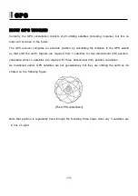
GPS navigation uses satellite signals to determine your position in relation to a set of satellite o
rbiting the earth. The GPS constellation of satellites continuously send radio signals, containing
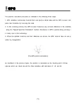
the precise position for each satellite back to earth. By knowing the position of 3 or 4 satellites
and calculating various time differences between transmitted signals, the GPS receiver can det
ermine its present position anywhere on earth, and thanks to continuous updates, calculate spe
ed and course information.
Содержание Smart7 Series
Страница 8: ... 8 ...
Страница 13: ... 13 Smart7 Series System Metal Front Rear Main Screen Keypad Knob Mounting Bracket Connector ...
Страница 14: ... 14 Smart7 Series System Plastic Front Rear Main Screen Keypad Knob Mounting Bracket Connector ...
Страница 15: ... 15 Smart7 Series System SPEC of the connectors Metal SPEC of the connectors Plastic ...
Страница 21: ... 21 Display Chartplotter Data bar Scale Vessel icon AIS target ...
Страница 24: ... 24 Display Steering Destination waypoint name Destination waypoint NAV Information Direction of XTE ...
Страница 25: ... 25 Display GPS Information Satellite List Gain of Satellite Receiver status ...
Страница 86: ... 86 ...


