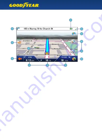
What’s On Screen
Explanation of GPS map screen
6
The top bar shows the upcoming turn direction, distance, and road name.
When there is no immediate upcoming turn, it also shows the current road name.
Tip :
Tap the top bar to repeat the last spoken command.
GPS Satellite strength – Red means weak or no signal. You can tap this icon to see a
larger compass, number of satellites present, and your current latitude and longitude.
Battery Indicator – shows current battery strength, or if the GPS unit is plugged
into a power source.
Tap here to go to the Navigation Menu.
Tap here for the Route Information screen, and to set a detour.
The compass icon shows your current direction.
Tap this icon to cycle the map direction between Car Up, North Up, or 3D View.
Tap the + or – icons to zoom in or out of the map.
Tap the auto-zoom icon to return to automatic zoom.
Note :
The map automatically zooms based on location and speed, and auto-zoom
settings can be changed in the Display Settings menu.
Volume Settings – tap this icon to raise or lower the speech volume and button volume.
Local Points of Interest icons show selected locations nearby.
The bottom bar shows your Estimated Time of Arrival, Distance to Arrival,
and Time to Go. When not on a route, the display shows the Current Time and Speed.
1
•
2
•
3
•
4
•
5
•
6
•
7
•
8
•
9
•
10
•
1
2
3
4
5
6
7
7
8
9
10
10
10


