


GNS 530(A) Pilot’s Guide and Reference
190-00181-00 Rev. H
SECTION 3
NAV PAGES
3-7
An autozoom feature is available which automatically
adjusts from an enroute range of 2000 nm through
each lower range, stopping at a range of 1.0 nm when
approaching the destination waypoint. The autozoom
feature is turned on/off from the
Map Setup Page (described
in Section 3.4).
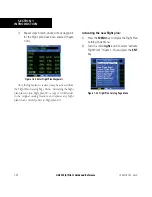
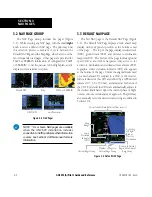
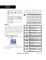
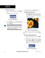
The
Map Page also displays a background map (or
‘basemap’) showing lakes, rivers, coastlines, highways,
railways, and towns. When a
map range is selected below
the lower limit at which the map detail was originally
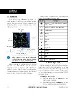
created, an ‘overzoom’ indication appears on the Map
Display, below the range reading (Figure 3-10). The
basemap has limited accuracy, and should not be used
for navigation, but only for non-navigational situational
awareness. Any basemap indication should be compared
against other navigational sources for accuracy. Continuing
to zoom in to lower range settings will cause ‘overzoom’ to
be replaced with ‘no map’ and the geographic detail will
be removed from the Map Display (airport and NAVAID
remain).
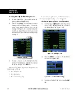
Figure 3-10 Overzoom on Map Page
The ‘Setup Map?’ option (described in Section 3.4)
allows the pilot to define the maximum range at which
each map feature appears. This provides the pilot with
complete control to minimize screen clutter. The pilot
can also quickly remove items from the map using the
CLR
Key.
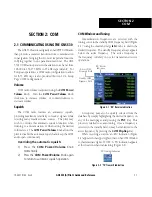
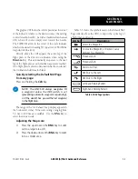
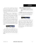
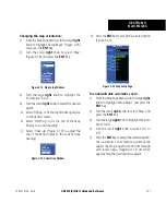
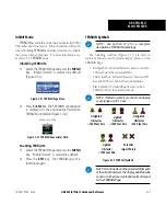
Quickly decluttering the Map Display:
Press the
CLR
Key momentarily (as often as
needed) to select the desired amount of map
detail.
The
CLR
Key allows the pilot to quickly declutter the
Map Display, providing four levels of map detail. Note the
‘-1’ (‘-2’ and ‘-3’ are also provided) suffix designation in
Figure 3-11, indicating each successive declutter level.
Map Detail Level
Figure 3-11 Detail Level on Map Page
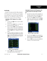
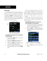
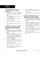
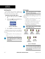
Five user-selectable data fields can be added to the
right-hand side of the Map Display. By default, the
displayed data is: destination waypoint name (WPT),
desired
track (DTK), ground track (TRK), distance to
destination waypoint (DIS), and ground speed (GS).
Adding these data fields or changing the data types is
outlined in Section 3.4. The five
data fields can also be
removed from the map to show a larger map image, as
shown in Figure 3-9.
Содержание GNS 530
Страница 1: ...GNS 530 A Pilot s Guide and Reference ...
Страница 2: ......
Страница 10: ...GNS 530 A Pilot s Guide and Reference 190 00181 00 Rev H viii WARRANTY Blank Page ...
Страница 82: ...GNS 530 A Pilot s Guide and Reference 190 00181 00 Rev H 5 16 SECTION 5 FLIGHT PLANS Blank Page ...
Страница 116: ...GNS 530 A Pilot s Guide and Reference 190 00181 00 Rev H SECTION 6 PROCEDURES 6 34 Blank Page ...
Страница 142: ...GNS 530 A Pilot s Guide and Reference 190 00181 00 Rev H 7 26 SECTION 7 WPT PAGES Blank Page ...
Страница 190: ...GNS 530 A Pilot s Guide and Reference 190 00181 00 Rev H 10 30 SECTION 10 AUX PAGES Blank Page ...
Страница 270: ...GNS 530 A Pilot s Guide and Reference 190 00181 00 Rev H SECTION 16 MESSAGES ABBREVIATIONS NAV TERMS 16 14 Blank Page ...
Страница 274: ...GNS 530 A Pilot s Guide and Reference 190 00181 00 Rev H APPENDIX B SPECIFICATIONS B 2 Blank Page ...
Страница 286: ...GNS 530 A Pilot s Guide and Reference 190 00181 00 Rev H I 6 INDEX ...
Страница 287: ......


