background image

4-3

190-01150-02  Rev. J

Garmin G500H Pilot’s Guide

For

ewor

d

Sec 1 

System

Sec 2


PFD

Sec 3


MFD

Sec 4


Hazar

Avoidance

Sec 5


Additional 

Featur

es

Sec 6


Annun. 

& Alerts

Sec 7


Symbols

Sec 8


Glossary

Appendix A

Appendix B


Index

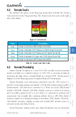
4.2  Terrain Scale

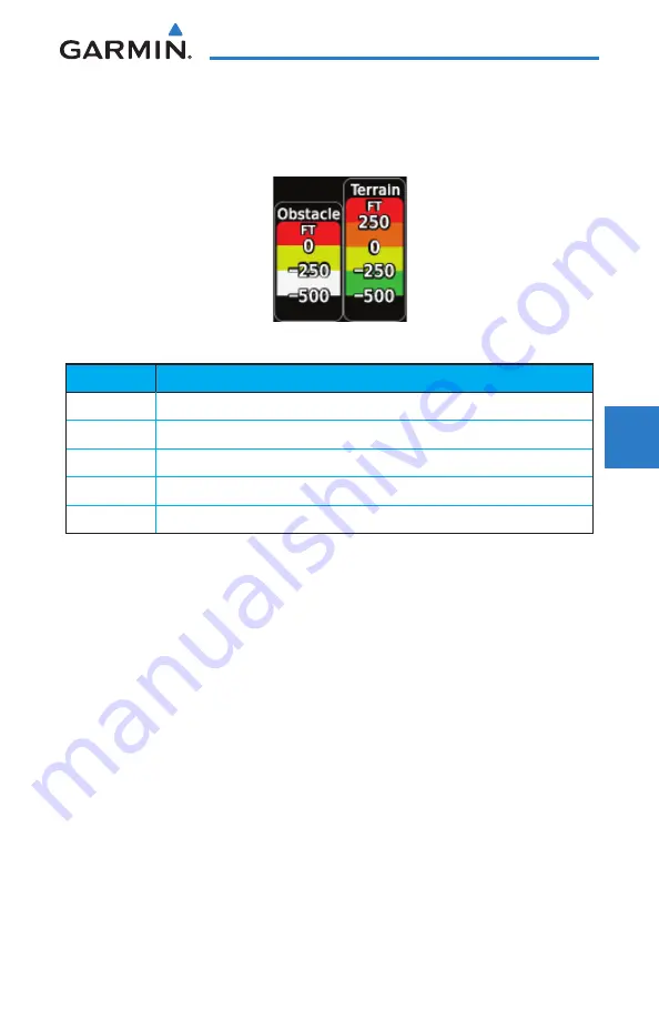
The Terrain Scale option in the Map page group selects whether the Terrain 

Scale is shown on the Navigation Map. The Terrain scale is located on the right 
side of the display. 

Figure 4-1  Terrain Scale

Color

Description

Black

Terrain is more than 500 ft below the aircraft. 

Green

Terrain is between 250 ft below and 500 ft below the aircraft. 

Yellow

Terrain is between 250 ft below and 0 ft above the aircraft. 

Orange

Terrain is between 0 ft above and 250 ft above the aircraft.

Red

Terrain is more than 250 ft above the aircraft. 

Table 4-2  Terrain Scale Color Codes

4.3  Terrain Proximity

Garmin Terrain Proximity is a non-TSO-C194-certified terrain awareness 

system provided as a standard feature of GDU 620 to increase situational 
awareness and help reduce controlled flight into terrain (CFIT). Terrain may be 
displayed on the Map page group Navigation Map and Terrain pages. 

Terrain Proximity uses information provided from the GPS receiver to 

provide a horizontal position and altitude. GPS altitude is derived from satellite 
measurements. GPS altitude is converted to a Mean Sea Level (MSL)-based 
altitude (GPS-MSL altitude). GPS-MSL altitude accuracy is affected by factors 
such as satellite geometry, but it is not subject to variations in pressure and 
temperature that normally affect pressure altitude devices. GPS-MSL altitude 
does not require local altimeter settings to determine MSL altitude. Therefore, 
GPS altitude provides a highly accurate and reliable MSL altitude source to 
calculate terrain and obstacle alerts. 

Terrain Proximity utilizes terrain and obstacle databases that are referenced 

Содержание G500H

Страница 1: ...G500H Pilot s Guide ...

Страница 2: ...tored in any storage medium for any purpose without the express written permission of Garmin Garmin hereby grants permission to download a single copy of this manual and of any revision to this manual onto a hard drive or other electronic storage medium to be viewed for personal use provided that such electronic or printed copy of this manual or revision must contain the complete text of this copy...

Страница 3: ...EXPRESS IMPLIED OR STATUTORY INCLUDING ANY LIABILITY ARISING UNDER ANY WARRANTY OF MERCHANTABILITY OR FITNESS FOR A PARTICULAR PURPOSE STATUTORY OR OTHERWISE THIS WARRANTY GIVES YOU SPECIFIC LEGAL RIGHTS WHICH MAY VARY FROM STATE TO STATE INNOEVENTSHALLGARMINBELIABLEFORANYINCIDENTAL SPECIAL INDIRECTORCONSEQUENTIAL DAMAGES WHETHER RESULTING FROM THE USE MISUSE OR INABILITY TO USE THE PRODUCT OR FRO...

Страница 4: ...gree of functional integrity However the pilot must recognize that providing monitoring and or self test capability for all conceivable system failures is not practical Although unlikely it may be possible for erroneous operation to occur without a fault indication shown by the G500H It is thus the responsibility of the pilot to detect such an occurrence by means of cross checking with all redunda...

Страница 5: ... link weather product Due to time delays inherent in gathering and processing weather data for data link transmission the weather information shown by the data link weather product may be significantly older than the indicated weather product age WARNING For safety reasons G500H operational procedures must be learned on the ground WARNING To reduce the risk of unsafe operation carefully review and...

Страница 6: ...and pilot near term decision making To cue the pilot to communicate with the Air Traffic Control controller Flight Service Station specialist operator dispatch or airline operations control center for general and mission critical meteorological information NAS status conditions or both FIS B information including weather information NOTAMs and TFR areas are intended for the sole purpose of assisti...

Страница 7: ...ntained within this document including screen images of the G500H bezel and displays are subject to change and may not reflect the most current GDU 620 system Depictions of equipment may differ slightly from the actual equipment NOTE This device complies with part 15 of the FCC Rules Operation is subject to the following two conditions 1 this device may not cause harmful interference and 2 this de...

Страница 8: ...NTIES WITH RESPECT TO THE AOPA INFORMATION INCLUDED IN THIS DATA EXPRESS OR IMPLIED INCLUDING BUT NOT LIMITED TO THE IMPLIED WARRANTIES OF MERCHANTABILITY AND FITNESS FOR A PARTICULAR PURPOSE THE INFORMATION IS PROVIDED AS IS AND AOPA DOES NOT WARRANT OR MAKE ANY REPRESENTATIONS REGARDING ITS ACCURACY RELIABILITY OR OTHERWISE UNDER NO CIRCUMSTANCES INCLUDING NEGLIGENCE SHALL AOPA BE LIABLE FOR ANY...

Страница 9: ... 1 7 1 1 2 Optional Line Replaceable Units LRU 1 8 1 1 2 1 GDL 88H Optional 1 8 1 1 2 2 Weather Radar 1 8 1 1 2 3 Stormscope Optional 1 8 1 1 2 4 GSR 56 Optional 1 8 1 1 2 5 GDL 69 69A Optional 1 9 1 1 2 6 GAD 43 43e Optional 1 9 1 1 2 7 GTX 330 330D Optional 1 10 1 2 System Power Up 1 11 1 3 International Geomagnetic Reference Field 1 13 1 4 System Operation 1 14 1 4 1 Pilot Controls 1 14 1 4 1 1...

Страница 10: ...2 Turn Rate Indicator 2 20 2 7 Course Deviation Indicator 2 20 2 7 1 Changing CDI Sources 2 21 2 7 2 Changing CDI Course 2 22 2 7 3 Vertical Deviation Indicator VDI 2 23 2 7 4 Auto Slewing 2 24 2 8 Supplemental Flight Data 2 26 2 8 1 Bearing Pointers 2 26 2 8 2 Temperature Display 2 28 2 8 3 Wind Vectors 2 28 2 8 4 DME Indication 2 29 2 8 5 Marker Beacon Annunciations 2 29 2 8 6 Miscompare Annunci...

Страница 11: ...Nav Status 3 33 3 2 1 5 Temperature Reference 3 33 3 2 1 6 Synchronization Dual Installations Only 3 34 3 2 1 7 Date and Time 3 36 3 2 1 8 MFD Display Units 3 37 3 2 1 9 System Display Units 3 38 3 2 2 Sirius XM Satellite Radio XM Information Optional 3 39 3 2 3 Sirius XM Satellite Radio XM Entertainment Radio Optional 3 40 3 2 4 System Status 3 41 3 2 4 1 Database Sync Operation 3 42 3 2 4 2 Reso...

Страница 12: ...rain Scale 4 3 4 3 Terrain Proximity 4 3 4 3 1 Displaying Terrain Proximity 4 5 4 3 1 1 Terrain Proximity Page Display on the Terrain Page 4 5 4 3 1 2 Terrain Proximity Page Display on a Navigation Map Page 4 6 4 3 1 3 Terrain Proximity Page 120 Arc or 360 Rings 4 6 4 3 1 4 Terrain Proximity Page Aviation Data 4 8 4 3 2 Terrain Proximity Limitations 4 9 4 3 3 System Status 4 9 4 4 External H TAWS ...

Страница 13: ...37 4 6 3 1 Target Selection 4 38 4 6 3 2 Status 4 39 4 6 3 3 Motion Vector 4 40 4 7 XM WX Satellite Weather Optional 4 42 4 7 1 Using XM WX Satellite Weather Products 4 42 4 7 2 Customizing the XM WX Satellite Weather Map 4 43 4 7 3 XM Weather Symbols and Product Age 4 45 XM WX Weather Symbols and Product Age 4 45 4 7 4 XM Weather Legends 4 47 4 7 5 XM NEXRAD 4 49 4 7 5 1 Reflectivity 4 51 4 7 5 2...

Страница 14: ...4 8 4 Weather Page Map Orientation 4 86 4 8 5 GFDS Data Request 4 87 4 8 5 1 GFDS Data Request Coverage 4 88 4 8 5 2 GFDS Data Request Auto Request 4 90 4 8 5 3 GFDS Data Request Manual Request 4 91 4 8 5 4 GFDS Data Request Status Window 4 91 4 8 6 Precipitation PRECIP Data Viewing Range 4 92 4 8 7 PRECIP Legend 4 93 4 8 8 GFDS Infrared Satellite IR SAT Data Viewing Range 4 94 4 8 9 Data Link Lig...

Страница 15: ...7 5 1 4 2 Selecting a New Chart by FPL NRST or RECENT 5 8 5 1 4 3 Selecting a Chart Manually 5 8 5 1 4 4 Chart Auto Selection 5 9 5 1 5 Using Charts 5 11 5 1 5 1 Chart Zooming and Panning 5 12 5 1 5 2 Viewing Chart Details in ChartView 5 13 5 1 5 3 Setting the Altitude Minimums Alerter 5 15 5 1 5 4 Viewing Chart NOTAMs 5 16 5 1 5 5 Day Night View 5 17 5 2 SafeTaxi 5 18 5 2 1 Using SafeTaxi 5 19 5 ...

Страница 16: ...5 5 4 3 2 Zero Pitch Line 5 35 5 4 3 3 Horizon Heading 5 36 5 4 3 4 Airport Signs 5 36 5 4 3 5 Runway Depiction 5 37 5 4 3 6 Traffic 5 38 5 4 3 7 Obstacles 5 39 5 4 3 8 Field of View 5 40 5 4 3 9 Unusual Attitudes 5 42 6 Annunciations and Alerts 6 1 6 1 Alerts 6 1 6 2 System Status 6 14 7 Symbols 7 1 7 1 Map Page Symbols 7 1 7 2 SafeTaxi Symbols 7 2 7 3 Traffic Symbols 7 2 7 4 Terrain Obstacle Sym...

Страница 17: ...graphical flight instrumentation attitude heading airspeed altitude vertical speed replacing the traditional flight instrument cluster The Multi Function Display MFD normally displays a full color moving map with navigation information as well as supplemental data GMU 44 Magnetometer Garmin Navigator s GTP 59 Temperature Probe AHRS Air Data Computer GDU 620 Optional Interfaces Traffic Audio Panel ...

Страница 18: ...rd party radios Autopilot Flight Director ADF Garmin GTS or GTX traffic awareness systems or selected 3rd party devices Audio Panel Garmin GWX radar systems or selected 3rd party radars Radar Altimeter Video Sources Stormscope 1 1 1 Standard System Line Replaceable Units LRU This guide covers the operation of the GDU 620 display as integrated in the G500H system The G500H Avionics Display System i...

Страница 19: ...allations the PFD and MFD and their controls are switched to the other side The MFD shows a moving map flight plan weather and other supplemental data The PFD shows primary flight information in place of traditional pitot static and gyroscopic systems and also provides an HSI for navigation Figure 1 2 GDU 620 PFD and MFD 1 1 1 2 Air Data Computer ADC The Air Data Computer ADC compiles information ...

Страница 20: ...tal interface Figure 1 4 AHRS The International Geomagnetic Reference Field IGRF model is contained in the AHRS and is updated once every five years The IGRF model is part of the Navigation Database At system power up the IGRF models in the AHRS and the Navigation Database are compared If the IGRF model in the AHRS is out of date the user is prompted to update The prompt will appear after the G500...

Страница 21: ... in loss of attitude and heading information This is indicated by red X flags over the corresponding flight instruments A maximum of two GPS inputs are provided to the AHRS If GPS information from one of the inputs fails the AHRS uses the remaining GPS input and an alert message is issued to inform the pilot If both GPS inputs fail the AHRS will continue to provide attitude and heading information...

Страница 22: ...RS is receiving valid GPS information Invalid or unavailable airspeed data in addition to complete GPS failure results in loss of all attitude and heading information NOTE FastestAHRS alignment is achieved with the aircraft stationary and with allAHRS inputs valid 3 D GPS position magnetometer and air data During initial power up on the ground no GPS position and or magnetic anomalies are common I...

Страница 23: ...This unit receives power directly from the GRS 77H and communicates with the GRS 77H using a RS 485 digital interface Figure 1 7 GMU 44 Magnetometer 1 1 1 5 GTP 59 The GTP 59 temperature probe provides Outside Air Temperature OAT data to the GDC 74H Figure 1 8 GTP 59 Temperature Probe 1 1 1 6 Garmin Navigator Interface The G500H system requires connection to at least one external Garmin WAAS GPS n...

Страница 24: ...ith or without an internal GPS SBAS receiver 1 1 2 2 Weather Radar The Garmin GWX system or selected 3rd party radar provides airborne weather and ground mapped radar data to the MFD Figure 1 10 GWX 68 Weather Radar 1 1 2 3 Stormscope Optional NOTE Refer to the WX 500 Pilot s Guide for a detailed description of the WX 500 StormScope The WX 500 StormScope Weather Mapping Sensor is a passive weather...

Страница 25: ...ellite Radio service is required to enable the GDL 69 69A capability Subscription information is available at http www garmin com xm Figure 1 11 GDL 69 69A XM Satellite Radio Data Link Receiver 1 1 2 6 GAD 43 43e Optional The GAD 43 is an adapter that converts AHRS digital pitch roll heading and yaw rate data into analog signals used by autopilot systems The GAD 43 is installed remotely between th...

Страница 26: ...dix A Appendix B Index Figure 1 12 GAD 43 43e AHRS Adapter 1 1 2 7 GTX 330 330D Optional Figure 1 13 GTX 330 330D Mode S Transponder The GTX 330 330D is a solid state transponder that provides Modes A C and S functions The transponder provides traffic information to the display through an ARINC 429 digital interface NOTE GTX 33 33D can also be used to display traffic information on the GDU 620 ...

Страница 27: ...ions should disappear typically within the first 30 seconds after power up Upon power up bezel key backlights also become momentarily illuminated on the GDU 620 display bezel On the PFD the AHRS begins to initialize and AHRS ALIGN Keep Wings Level is displayed The AHRS should display valid attitude and heading fields typically within the first minute and a half after power up The AHRS can align it...

Страница 28: ...database expiration date Airport Directory database expiration date Chart database status Databases are displayed in white if they are determined to be current Databases are displayed in yellow if they have expired are not yet effective or if the current date time is not yet available from the GPS Figure 1 12 System Startup Pages When the interfaced GPS unit has acquired a sufficient number of sat...

Страница 29: ...IGRF models in the GRS 77 and in the Navigation Database are compared and if the IGRF model in the GRS 77 is out of date the user is prompted to update the IGRF model in the GRS 77 The following prompt will appear after the G500H splash screen is acknowledged on the MFD GRS MV DB UPDATE AVAILABLE UPDATE FROM yyyy TO yyyy e g 2005 to 2010 Follow the on screen instructions 1 When the Update message ...

Страница 30: ...ted on the PFD and MFD bezels and are comprised of a PFD knob MFD dual concentric knobs bezel keys and soft keys 1 4 1 1 PFD Knob Pressing the PFD knob performs the default action for the selected mode Refer to the PFD Bezel Keys section for details Heading Mode Course Mode Altitude Mode Vertical Speed Mode Barometer Mode Figure 1 14 Selection Modes Adjusted with the PFD Knob NOTE After 10 seconds...

Страница 31: ...n the current Heading Set the heading bug on the HSI by turning the PFD knob after pressing the HDG key Course CRS Selects Course Select mode Pressing the PFD knob in Course mode will center the CDI for a VOR or GPS OBS course Altimeter ALT Selects Altitude Select mode Pressing the PFD knob in Altitude Select mode will enter the current altitude in the Altitude Select window Set the Altitude Bug b...

Страница 32: ...g Setting Vertical Speed Bug Figure 1 16 Pressing V S Knob Sets Vertical Speed Bug to Current Vertical Speed For helicopters with vertical speed operating limitations red bands showing Vertical Speed Maximum and Minimum ranges will be shown on the left side of the Vertical Speed tape When the Vertical Speed Indicator is in one of the red ranges the background color of the Vertical Speed Indicator ...

Страница 33: ...applicable window by turning the small and large MFD knobs In this case the large MFD knob moves the cursor on the page and the small MFD knob selects individual characters or values for the highlighted cursor location Large Outer MFD Knob Selects the MFD page group When the cursor is ON the large MFD knob moves the cursor to highlight available fields 1 4 1 4 MFD Bezel Keys Range RNG Pressing the...

Страница 34: ...s shown depend on the soft key level or page being displayed The bezel keys below the soft keys can be used to select the appropriate soft key MFD functions indicated by the soft key labels vary depending on the page selected and are located at the bottom of the MFD display Press the soft key located directly below the soft key label To select the function indicated on the soft key label press the...

Страница 35: ...w page There is no all encompassing menu Some menus provide access to additional submenus that are used to view edit select and review options Menus display No Options when there are no options for the window page selected Soft key presses do not display menus or submenus Navigating within a Menu 1 Press the MENU key to display the menu 2 Turn the small or large MFD knob to scroll through a list o...

Страница 36: ...s G500H system settings are managed from the Aux Mode System Setup Page The following settings can be changed Display Brightness Mode and Level Airspeed References Glide and Vy PFD Options Wind Vector and Nav Status Date Time Date Time Time Format and Time Offset MFD Display Units Distance Speed and Altitude Vertical Speed System Display Units Navigation Angle Reference Pressure Units and Temperat...

Страница 37: ...ing More detail on changing settings is in the Section 3 MFD Aux pages System Settings section Category Settings Affected Quantities Exceptions Display Brightness Level Mode Brightness levels on the PFD and MFD Airspeeds Glide or REF VR VX or V1 VY or V2 Reference markers on PFD airspeed tape Synchronization CDI On Off BARO On Off Crossfill Nav information to GDU 620 PFD Options Wind Vector NAV St...

Страница 38: ...atus Box All distances on MFD All speeds on MFD Airspeed Indicator True Airspeed Wind speed vector Map range Traffic Page Terrain Proximity Page Altitude and Vertical Speed Feet Meters All elevations on MFD Altimeter Vertical Speed Indicator Navigation Angle Magnetic North True North Heading Course Bearing Track Desired Track Barometric Setting Inches in Hectopascals hpa Barometric pressure on PFD...

Страница 39: ...ighting conditions Photocell calibration curves are configured by the installer to optimize display appearance through a broad range of cockpit lighting conditions Manual backlighting adjustment can be accomplished using the existing instrument panel dimmer bus or the following procedures Backlighting Adjustment 1 From the first AUX page press the small MFD knob to highlight the DISPLAY BRIGHTNESS...

Страница 40: ... Guide 190 01150 02 Rev J Foreword Sec 1 System Sec 2 PFD Sec 3 MFD Sec 4 Hazard Avoidance Sec 5 Additional Features Sec 6 Annun Alerts Sec 7 Symbols Sec 8 Glossary Appendix A Appendix B Index This page intentionally left blank ...

Страница 41: ...t Course Select Heading Bug Select Air Temperature Air Speed Tape Horizon Line Trim Ball Indicator Roll Scale Zero Roll Pointer Wind Vectors Figure 2 1 PFD Description Ground Pointer Mode Current Nav Source Current FPL Leg Wpt Distance from Your Present Position to Current FPL Leg Wpt Current Track Desired Track Nav Status Style 1 Top of Display Nav Status Style 2 Left of HSI Figure 2 2 PFD Nav St...

Страница 42: ...ource 1 Source 2 AP TEST PFD SYN VIS SYN TERR HRZN HDG APTSIGNS DME DME NAV 1 DME NAV 2 DME HOLD BRG 1 NAV 1 GPS 1 ADF BRG 2 NAV 2 GPS 2 ADF BRG CLK TMR HIDE CLOCK TIMER START STOP RESET BACK Figure 2 3 PFD Soft Key Diagram The soft keys are located along the bottom of the displays below the soft key labels The soft key labels shown depend on the soft key level or page being displayed The soft key...

Страница 43: ...and held for longer than 1 second it is ignored AP Test The AP TEST soft key is available if the GAD 43 is used to provide attitude information to an autopilot The AP TEST soft key disengages the autopilot as part of the GAD 43 test CDI The CDI soft key toggles between the selection of GPS or VOR LOC as the active navigation source The GDU CDI soft key will change the source in the connected navig...

Страница 44: ...ntrols vary based on the installation The DME NAV soft keys select NAV 1 or 2 as the DME tuning source If this soft key is pressed again when already selected the DME display is removed from the PFD Not all installations will have both NAV1 and NAV2 soft keys Selected DME DME Information Set Hold for Selected DME DME Hold Annunciation Figure 2 5 DME Soft Keys DME HOLD DME HOLD activates deactivate...

Страница 45: ...sing this key enables horizon heading marks and digits APTSIGNS The APTSIGNS soft key is available if Synthetic Vision Technology is installed and enables airport sign posts for airports Only heliports in the current flight plan are shown CLK TMR The Clock Timer function displays a clock or timer window in the lower left corner of the PFD Hide Timer Hide Clock Select Clock Select Timer Start Timer...

Страница 46: ... in six seconds if the current acceleration is maintained The actual airspeed is displayed inside the black pointer The Airspeed Trend Vector is a vertical pink magenta line extending up or down on the airspeed scale shown to the right of the color coded speed range strip The end of the trend vector corresponds to the predicted airspeed in six seconds if the current acceleration is maintained If t...

Страница 47: ...markings for the installation See the AFM POH NOTE The actual colors and patterns of the airspeed tape may vary by installation See your AFM POH for more details 2 2 2 Reference Speeds V speeds Glide and VY default values are set during the installation process but can be changed and turned on off from the System Setup page on the first page of the Aux page group When active on the V speeds are di...

Страница 48: ...ine is part of the pitch scale Above and below the horizon line major pitch marks and numeric labels are shown for every 10º up to 80º Minor pitch marks are shown for intervening 5º increments up to 25º below and 45º above the horizon line Between 20º below to 20º above the horizon line minor pitch marks occur every 2 5º Angle of bank is indicated by the position of the pointer on the roll scale M...

Страница 49: ... that has a Ground Pointer the pointer above the Roll Scale shifts with the roll or bank angle of the aircraft to keep the Roll Scale Zero Pointer pointing towards the ground Roll Pointer Roll Scale Zero Pointer Roll Scale Figure 2 11 Attitude Indicator with a Ground Pointer configuration in a left turn In an aircraft with an Attitude Indicator that has a Sky Pointer the pointer below the roll sca...

Страница 50: ...treme attitude Only the primary functions will be displayed in these situations The following information is removed from the PFD and corresponding soft keys are disabled when the aircraft is in an unusual attitude PFD Knob Mode Annunciations Ground Speed True Airspeed and Airspeed Units Selected Altitude Barometer Settings and Selected Vertical Speed Vertical Course Deviation Indicator Traffic an...

Страница 51: ...Pilot s Guide Foreword Sec 1 System Sec 2 PFD Sec 3 MFD Sec 4 Hazard Avoidance Sec 5 Additional Features Sec 6 Annun Alerts Sec 7 Symbols Sec 8 Glossary Appendix A Appendix B Index Figure 2 16 Extreme Roll Indication with Display Declutter ...

Страница 52: ...tained The Altitude Bug is displayed at the selected Altitude Bug setting A portion of the Altitude Bug will be displayed at the top or the bottom of the altitude tape if the selected Altitude Bug is off of the tape When an optional Radar Altimeter is installed the altitude received from the radar altitude will be displayed on the PFD See the Radar Altimeter section for more details 2 4 1 Setting ...

Страница 53: ...nfigured Whentheaircraftpasseswithin200feetoftheSelectedAltitude theSelected Altitude changes to light blue text on a black background and flashes for five seconds and an aural tone may be generated if configured After reaching the Selected Altitude if the pilot flies outside the deviation band beyond 200 feet of the Selected Altitude the Selected Altitude changes to yellow text on a black backgro...

Страница 54: ...ums window at the bottom left of the Altitude Tape when you are within 2500 feet of the selected minimum altitude NOTE The Altitude Minimums Alerting Bug appears parked at the bottom of the altitude tape as soon as a value is set in the minimums alerter The bug will unpark and start to move up the tape as soon as the altitude is within the range of the tape The bug is reset when power is cycled Th...

Страница 55: ... selection of altitudes in 100 foot increments When a value other than 100 feet is set for Baro Mins it becomes a selectable value in the altitude alerter In dual installations the minimums alerting altitude value may be set from either GDU 620 and will be synchronized on both units Setting the Altitude Minimums Bug is performed on either the FPL Active Flight Plan page or the FPL Charts page For ...

Страница 56: ...l speed using a non moving tape The tape can be scaled at 2000 3000 or 4000 fpm as set by the installer Major gradations are every 1000 fpm and minor gradations every 500 fpm The current vertical speed is displayed in the pointer along the tape Digits appear in the pointer when the climb or descent rate is greater than 100 fpm If the rate of ascent descent exceeds the vertical speed displayed on t...

Страница 57: ...rent ground track is represented on the HSI by a magenta diamond The HSI also presents turn rate course deviation bearing and navigation source information The MSG annunciation will be shown in the HSI when an unacknowledged message is present on the selected navigator When the message is acknowledged the MSG annunciation will clear 11 7 6 5 3 2 1 12 10 4 14 15 13 8 9 16 1 Turn Rate Indicator 2 Co...

Страница 58: ...rrow rotates with the course pointer and is displayed when the active NAVAID is received 2 6 1 Setting the Heading Bug The Selected Heading is shown to the upper left of the HSI for 10 seconds after being adjusted The light blue bug on the compass rose corresponds to the Selected Heading NOTE The current heading will have a T to the right of the heading value when the Nav Angle is set to True in t...

Страница 59: ...e trend vector stopping at the standard turn rate tick mark corresponding to a predicted heading of 18º from the current heading At rates greater than four deg sec an arrowhead appears at the end of the magenta trend vector and the prediction is no longer valid Turn Rate indication Arrowhead shown for a Turn Rate 4 deg sec Standard Turn Rate Standard Turn Rate Current Track Indicator Lubber Line H...

Страница 60: ...e of the display 2 7 1 Changing CDI Sources The CDI can display two sources of navigation GPS or NAV VOR and LOC Color indicates the current navigation source magenta for GPS or green for VOR and LOC The full scale limits for the CDI are defined by a GPS derived distance when coupled to GPS When coupled to a VOR or localizer LOC the CDI has the same angular limits as a mechanical CDI If the CDI ex...

Страница 61: ...the navigation source by the indication on the HSI and in the upper left corner of the PFD NOTE The selected navigator is the active navigator for all PFD and MFD operations except for the supplemental bearing pointers 2 7 2 Changing CDI Course The Selected Course is shown to the upper left of the HSI for 10 seconds after being adjusted New Course Setting Figure 2 27 Course Setting 1 Press the CRS...

Страница 62: ... is only shown if the current heading is within 90 of the selected inbound course This prevents the glideslope from being displayed during localizer backcourse approaches Vertical Deviation Source Vertical Deviation Indicator Figure 2 28 Vertical Deviation Indicator ILS Source The vertical deviation is similar to the glideslope for GPS approaches supporting WAAS vertical guidance LNAV V L VNAV LPV...

Страница 63: ...LOC BC LDA or SDF approach when the steps below are completed in the following order 1 The desired approach is selected and activated in the navigator this can be verified by the approach waypoints appearing on the GDU620 MFD Nav Map Page or FPL Page 2 The appropriate frequency is the active frequency in the navigator 3 The CDI selection on the GDU 620 is changed to NAV course pointer for the acti...

Страница 64: ...final on an active ILS approach with the appropriate approach in the GPS navigator 2 The appropriate ILS frequency must be activate in the navigator 3 Verify that the waypoints for the approach are displayed on the Nav Map Page or the FPL Page of the MFD 4 Upon approaching the final course select LOC on the HSI NOTE If auto CDI switching is active on the GPS unit the GPS will force the GPS GDU 620...

Страница 65: ...the HSI for NAV and GPS sources The pointers are light blue and are single BRG1 or double lined BRG2 an icon is shown in the respective information window to indicate the pointer type The system must be configured for a second navigation source to show the BRG2 selection When a Bearing Pointer is displayed its associated information window is also displayed The Bearing Information windows are disp...

Страница 66: ...validity Bearing 2 Pointer Bearing 1 Pointer Icon Bearing 2 Pointer Icon Bearing 2 Source GPS Level of Service Current Navigation Source CDI Bearing 1 Pointer Bearing 1 Source Figure 2 32 HSI with Bearing Information CDI Source GPS Mode GPS Advisory LOI Suspend MSG LOI OBS SUSP GPS1 GPS2 VOR1 VOR2 LOC1 LOC2 OCN ENR TERM APR LNAV LNAV V LPV LNAV VNAV LP LP V 1 00nm 0 30nm Figure 2 33 PFD HSI Annunc...

Страница 67: ...ing stationary at the current location Total Air Temperature TAT This is the calculated temperature of the outside air as it moves past the aircraft including the rise in temperature due to air compression and friction at the current airspeed Difference from International Standard Atmosphere ISA This is the difference between SAT and standard ISA temperature at the current altitude This provides a...

Страница 68: ... Information Set Hold for Selected DME DME Hold Annunciation Figure 2 37 DME Indication NOTE The capability of providing DME information requires installation of the GAD 43e 2 8 5 Marker Beacon Annunciations A visual annunciation of marker beacons will be shown on the display when the aircraft flies over a marker beacon The marker beacon annunciation will appear to the left of the altitude tape be...

Страница 69: ...least one second Parameter Range of Trigger Threshold Altitude ALL 200 ft Indicated Airspeed Both IAS 35 kts Inhibited Indicated Airspeed Either IAS 35 kts 10 kts Indicated Airspeed Either IAS 80 kts 7 kts Pitch ALL 5 degrees Roll ALL 6 degrees Table 2 2 Miscompare Conditions A MISCOMP annunciation is displayed on the airspeed tape if a miscompare condition exists for indicated airspeed A MISCOMP ...

Страница 70: ...The use of ATT SYNC function moves the miniature aircraft to the horizon line and allows aircraft attitude to be controlled with more precision and less effort When the ATT SYNC function is active small reference marks are shown on the sides of the attitude indicator that show the absolute pitch reference The miniature aircraft symbol cannot be synchronized to the horizon line if the pitch attitud...

Страница 71: ...e Foreword Sec 1 System Sec 2 PFD Sec 3 MFD Sec 4 Hazard Avoidance Sec 5 Additional Features Sec 6 Annun Alerts Sec 7 Symbols Sec 8 Glossary Appendix A Appendix B Index Figure 2 41 Before Attitude Sync Selected Figure 2 42 After Attitude Sync Selected ...

Страница 72: ...ifference Figure 2 43 Radar Altimeter Display 150 foot RA Altitude When the radar altitude is 0 the brown band will be level with the altitude tape pointer As the radar altitude increases above 0 the brown band will move down the tape in an amount equal to the current radar altitude Barometric Altitude Radar Altimeter Value Brown Band Indicating The Ground 0 Foot Difference Figure 2 44 Radar Altim...

Страница 73: ...will not match the expected value The RA FAIL annunciation will appear on the PFD when the GDU is not receiving any Radar Altimeter data RA FAIL is not related to the self test Figure 2 46 Radar Altimeter Failure Annunciation Radar Altimeter Configurations Depending on the installation the pilot will have one of the following options 1 BARO or RAD ALT minimums altitude alert pilot selectable The m...

Страница 74: ...etting of 200 feet The pilot can select alerts ON or OFF and select the alert altitude based on radar altitude The alert upon descending through the selected altitude is a unique tone The altitude required to arm the alerting is 50 feet above the selected altitude Additionally the unit may be configured by the installer for the following alerts An aural One Hundred Feet alert is always provided wh...

Страница 75: ... the default settings for the optional Weather WX pages Which data is displayed can be controlled by the DCLTR soft key and map page MENU selections The Navigation Map can be oriented four different ways North Up NORTH UP Track Up TRACK UP Desired Track Up DTK UP or Heading Up HDG UP Map Orientation Range Select Menu Clear Enter Small MFD Knob Select Page Large MFD Knob Select Page Group Soft Keys...

Страница 76: ...rmation can be displayed on the Navigation Map Pages Airports NAVAIDs airspace airways land data highways cities lakes rivers borders etc with names MapPointerinformation distance and bearing to pointer location of pointer name andotherpertinent information Map range Wind direction and speed Map orientation Icons for enabled map features Aircraft icon representing present position Nav range ring F...

Страница 77: ...y to return to the first page Home Page of the Map group 3 1 2 Map Overlay Icons Overlay icons are displayed to indicate data that will be depicted on the map pages The icons are shown onIf the icon is not displayed either the menu selection is not ON to display the data or the display range makes the data ineligible for display If the icon has a white X over it then the data is selected ON and th...

Страница 78: ...ing the displayed map range and pressing the RNG key will zoom in decreasing the displayed map range The Map Range is shown on the outer range ring The map ranges available are from 250 feet to 500 NM 3 1 5 Decluttering Map Pages The Map Declutter feature allows the pilot to progressively step through four levels of decluttering to remove map information The declutter level is displayed in the DCL...

Страница 79: ... TRSA Large City ADIZ Medium City Alert Areas Small City Caution Areas Small Town Danger Areas Freeways Warning Areas Highways Large Airports Roads Medium Airports Railroads Prohibited Areas Political Boundaries MOAs Traffic Symbols Runway Labels Lat Lon Grids Lightning Strike Data VORs NEXRAD Data NDBs River Lake Names Intersections Traffic Labels Class B Airspace Water Detail Class C Airspace Ac...

Страница 80: ... longitude position of the pointer the ETE from your present position to the pointer elevation at the pointer and bearing and distance to the pointer from your present position Information is related to the tip of the pointer Selected Point Map Pointer Present Position Figure 3 6 Navigation Map Pointer Location Information 1 While viewing a Map press the small MFD knob A flashing pointer will appe...

Страница 81: ...plies to airports NAVAIDs user created waypoints roads lakes rivers just about everything displayed on the map except route lines When an airport NAVAID or user waypoint is selected on the map display you can review information about the item 1 While viewing the Navigation Map pages of the Map page group press the small MFD knob to activate panning 2 Move the cursor with the small and large MFD kn...

Страница 82: ...urn the large or small MFD knobs to highlight Measure Bearing Distance and then press ENT Figure 3 8 Navigation Map Measure Distance Function 3 Your present position will be marked as the starting reference point To choose a different starting reference point turn the large or small MFD knobs to desired point and press ENT Figure 3 9 Measure Distance Starting Reference Point 4 Turn the large or sm...

Страница 83: ...rcraft 3 1 10 Map Setup The Map Setup selection from the Page Menu allows you to select which data will be displayed on the map 1 While viewing one of the Navigation Map pages of the Map page group press the MENU key to display the Navigation Map Page Menu Figure 3 11 Navigation Map Page Menu 2 With the cursor flashing on the Map Setup option Press the ENT key to display the Map Setup Menu 3 Use t...

Страница 84: ...om On Off NEXRAD Legend On Off INT NDB Viewing Range Off Range Land Data On Off XM Ltng Off Range VOR Viewing Range Off Range Track Vector Length Off Time Class B TMA Off Range Wind Vector On Off Class C TCA Off Range Enhanced Range Ring On Off Class D Off Range Topo Data On Off Restricted Off Range Topo Scale On Off MOA Military Off Range Terrain Data On Off Other ADIZ Off Range Obstacle Viewing ...

Страница 85: ...active turn the large MFD knob to highlight the desired option 2 Turn the small MFD knob to change the highlighted value 3 Press ENT to accept the displayed value The next option will be highlighted 4 Press the small MFD knob to cancel selection or to end editing and return to the Navigation Map page or turn the large MFD knob to the next option Map Orientation The Orientation option sets the orie...

Страница 86: ...Auto Zoom is re enabled once one of the following conditions is met Land Data The Land Data option selects whether detailed land features such as rivers roads cities are displayed Topo features traffic terrain and obstacles will still be displayed even with Land Data turned off Track Vector Length When turned on the Track Vector Length option will show a dashed line and arrow extending from the ai...

Страница 87: ... position on the Map page When selected ON the Enhanced Range Ring function provides a second ring at 1 2 the distance of the primary ring to allow the pilot to acccurately judge distance to objects depicted on the map Range Ring Radius Range Ring with Compass Rose Figure 3 16 Navigation Map Range Ring Topo Data The Topo Data option selects whether the colored topographical features are displayed ...

Страница 88: ... scale will be located on the right side of the display Current Aircraft Altitude Sky Indication Current Ground Level Indication Range of Topography Displayed on the Map Minimum Maximum Range of Topography Displayed on the Map Figure 3 18 Navigation Map Topo Scale Terrain Data The Terrain Data option selects whether Terrain Data is shown on the Navigation Map The Terrain Data Icon will be shown wh...

Страница 89: ...ircraft altitude Black Terrain is between 0 ft and 250 ft below the aircraft altitude Yellow Terrain is more than 250 ft above the aircraft altitude Red Terrain is between 0 ft and 250 ft above the aircraft altitude Orange 250 ft 250 ft Terrain is between 250 ft and 500 ft below the aircraft altitude Green 500 ft Figure 3 20 TERRAIN Altitude Color Correlation Unlighted Obstacle Lighted Obstacle Po...

Страница 90: ...acle is 250 ft or more below the aircraft altitude White Figure 3 22 H TAWS Obstacle Altitude Colors and Symbology Grouped obstacles are shown with an asterisk as shown in the Windmill in Group example above The color of the asterisks is tied to the relative altitude of the highest obstacle in the group not other obstacles within that group Obstacles are grouped when they would otherwise overlap I...

Страница 91: ...ls Sec 8 Glossary Appendix A Appendix B Index can be verified on the System Status page Power line data is available for the contiguous United States as well as small parts of Canada and Mexico Lat Lon Viewing Range The Lat Lon Viewing Range option selects whether Lat Lon line is shown on the MFD Lat Lon Reference Information Figure 3 23 Navigation Map Lat Lon Information ...

Страница 92: ...ex Field of View The Field of View represented by the synthetic terrain data used for the Garmin Synthetic Vision Technology SVT option when enabled can be represented on the MFD Navigation Map Page lateral image Two dashed lines forming a V shape in front of the aircraft symbol on the MFD represent the forward viewing area shown on the PFD Field of View Borders Figure 3 24 Navigation Map Field of...

Страница 93: ...may be selected for display on the MFD navigation map to predict where the ownship will be when it reaches the altitude selected on the altitude alerter on the PFD The distance from the ownship to the arc is based on ground speed baro altitude selected altitude and vertical speed The arc is shown when the aircraft is moving toward the selected altitude at a vertical speed of at least 150 feet per ...

Страница 94: ...d an XM WX Satellite Weather subscription or other weather product such as GFDS 1 While viewing the Navigation Map 1 or 2 page of the Map page group press the MENU key to display the Navigation Map Page Menu Figure 3 26 Navigation Map Page Menu 2 With the cursor flashing on the Map Setup option press the ENT key to display the Map Setup Menu 3 Use the large and small MFD knobs to select the Weathe...

Страница 95: ...ed the NEXRAD weather products will be shown at map ranges of 100 NM and lower NEXRAD Cell Movement TheNEXRADCellMovementoptionselectswhetherNEXRADCellMovement is shown on the Navigation Map NEXRAD Legend The NEXRAD Legend selection provides the option of displaying an abbreviated version of the NEXRAD legend in the top right region of the MFD Figure 3 28 NEXRAD Legend Selection Datalink Lightning...

Страница 96: ...r strikes will not be shown Where 100 NM is selected symbols will be shown at map ranges of 100 NM and lower NOTE The selected lightning display type cell or strike will be shown the same on both the StormScope and the Map pages NOTE StormScope data is displayed on the Map Page only if aircraft heading is available NOTE The G500 600 will display StormScope data with or without a heading source If ...

Страница 97: ...vice NOTE As a decluttering function traffic labels will not be drawn when the map scale is above 15 NM and traffic symbols will not be drawn when the map scale is above 40 NM Traffic Selection Display Result Off No traffic displayed All Traffic All types of traffic displayed TA PA Traffic Alerts and Proximity Alerts displayed TA Only Traffic Alerts Only displayed Table 3 4 Navigation Map Traffic ...

Страница 98: ...ns The Aviation group selection from the Map Setup Page Menu allows you to customize the display of SafeTaxi information Runway Extensions Intersection NDB locations VOR locations and TFR icons on the Navigation Map Figure 3 33 Navigation Map Page Menu Aviation Group Selection SafeTaxi Viewing Range The SafeTaxi viewing range option selects the range at which SafeTaxi information is shown on the N...

Страница 99: ...be shown at and below the selected map range When Off is selected the information will not be shown Where 100 NM is selected Class B TMA airspace information will be shown at map ranges of 100 NM and lower Class C TCA Airspace Viewing Range The Class C TCA airspace viewing range option selects whether Class C TCA airspace information is shown on the Navigation Map Class C TCA airspace information ...

Страница 100: ...er TFR Viewing Range optional The Temporary Flight Restriction TFR viewing range option selects whether TFR information is shown on the Navigation Map TFR information will be shown at and below the selected map range When Off is selected the information will not be shown Where 100 NM is selected TFR information will be shown at map ranges of 100 NM and lower This optional feature requires an activ...

Страница 101: ...ace Alerts that can be set on the System Alerts portion of the system Smart Airspaces Emphasized On Smart Airspaces De Emphasized Figure 3 34 Display of Smart Airspaces Airspace Borders Grayed When Emphasized Show Airspace The Airspace viewing range options select whether the Airspaces are shown on the Map and at and below the selected map ranges Figure 3 35 Display of Smart Airspaces Airspace Lab...

Страница 102: ...GE 1 except that TERRAIN TOPO and TRAFFIC can be turned on and off separately on this page 1 While viewing the Map function turn the small MFD knob to the third Navigation Map page Display of External Video Source Map Display Current Video Source Figure 3 37 External Video 2 The External Video page will show the external video on the top half of the MFD and a Navigation Map will be shown on the lo...

Страница 103: ... G500H system settings are managed from the Aux Mode System Setup Page The following settings can be changed Display Brightness Mode and Level Airspeeds Glide VR VX and VY PFD Options Wind Vector Nav Status Styles and Temp Reference Dual Unit Synchronization CDI Baro and some Databases Date Time Date Time Time Format and Time Offset MFD Display Units Distance Speed and Altitude Vertical Speed Syst...

Страница 104: ... While viewing the Aux mode System Setup page press the MENU key Figure 3 40 Aux Mode System Setup Page Menu 2 Turn the large or small MFD knobs to highlight the desired selection and then press ENT 3 2 1 1 Display Brightness Display brightness mode may be set to manual or automatic The automatic mode will set the display brightness based on the ambient light The manual mode allows the setting of ...

Страница 105: ...or the PFD are adjusted with this function A marker will appear on the PFD Airspeed tape at the selected speed when the value is set to On Default reference airspeeds are set during installation When power is cycled the values you set will be reset to the default values NOTE When power is cycled the Airspeed Reference values are reset During preflight the Airspeed Reference values should be checke...

Страница 106: ...f the HSI Four styles are available 1 While viewing the System Setup page of the AUX page group press the small MFD knob to activate the cursor Turn the large MFD knob to highlight the desired Wind Vector value 2 Turn the small MFD knob to select the style and press ENT Style 1 Style 2 Style 3 Style 4 Figure 3 44 Wind Vector Style 3 When a Wind Vector style is selected a Wind Vector box with the c...

Страница 107: ...3 45 Nav Status Style 3 After the Nav Status style is selected the chosen style will be displayed on the PFD NOTE Nav Status option is not available for all installations 3 2 1 5 Temperature Reference The computer calculates the temperature based on temperature probe and pitot static inputs The units C or F and temperature reference are selected on the AUX SYSTEM SETUP page The temperature referen...

Страница 108: ...e 2 Turn the small MFD knob to select the Temp Reference type and press ENT Figure 3 46 Outside Air Temperature Selection 3 2 1 6 Synchronization Dual Installations Only Dual GDU 620 units when connected in the aircraft may be set up to communicate and share information by Crossfilling or synchronizing information between the two units Crossfill synchronization for CDI and Baro Corrections are sel...

Страница 109: ...U will change it on both GDUs When the CDI is synchronized any changes to the selected CDI on either GDU will change it on both GDUs Either pilot can change the OBS course on either GPS If the pilot selects GPS1 on the CDI and GPS1 is in OBS mode any course changes will move the OBS on GPS1 GDU1 and GDU2 if the copilot has GPS1 displayed on the CDI Similarly if the pilot selects GPS2 on the CDI an...

Страница 110: ...ight Savings Time Offset Atlantic 4 hours 3 hours Eastern 5 hours 4 hours Central 6 hours 5 hours Mountain 7 hours 6 hours Pacific 8 hours 7 hours Alaskan 9 hours 8 hours Hawaiian 10 hours 9 hours Table 3 5 U S Time Zone Offsets 1 While viewing the System Setup page of the AUX page group press the small MFD knob to activate the cursor Turn the large MFD knob to highlight Time Format 2 Turn the sma...

Страница 111: ...of measurement conventions displayed on the MFD Distance and Speed selections are Imperial Metric or Nautical Altitude and Vertical speed selections are Feet or Meters ffic information is always shown in Nautical Miles distance and Feet altitude 1 While viewing the System Setup page of the AUX page group press the small MFD knob to activate the cursor Turn the large MFD knob to highlight the Dista...

Страница 112: ...us Pressing the DFLT UNIT soft key will restore the Default Unit settings 1 While viewing the System Setup page of the AUX page group press the small MFD knob to activate the cursor Turn the large MFD knob to highlight the System Display Units selection titled Nav Angle CAUTION The Nav Angle display units Magnetic or True must be set to the same type in both the GDU 620 and GPS navigators Figure 3...

Страница 113: ...g units and then press ENT The Temperature value will now be highlighted Figure 3 54 Temperature System Display Units 4 Turn the small MFD knob to select the Temperature units and then press ENT 3 2 2 Sirius XM Satellite Radio XM Information Optional The Aux mode XM Information page displays information about the Sirius XM Satellite radios service and products when the GDL 69 69A is installed and ...

Страница 114: ...variety of radio programming over long distances without having to constantly search for new stations Based on signal from satellites coverage far exceeds land based transmissions When enabled the Sirius XM Satellite Radio audio entertainment is accessible in Aux Mode The information on the Sirius XM Satellite Radio display is composed of four areas the Active Channel Available Channels Category o...

Страница 115: ...ge displays the statuses serial numbers and software version numbers for all detected system LRUs Pertinent information on all system databases is also displayed Active LRUs are indicated by green check marks failed LRUs by red X s Failed LRUs should be noted and a service center or Garmin authorized dealer informed Database SYNC allows a database to be synchronized with more than two LRUs G500 60...

Страница 116: ...base Sync Operation Database SYNC allows the G500 600 to synchronize databases from a single unit The pilot only needs to update a single database card and the new databases are automatically SYNC d through the units connected in the cockpit and configured for Database Syncing The following databases can be synchronized between using Database SYNC Navigation Obstacle SafeTaxi Airport Directory Cha...

Страница 117: ...mory to the newer databases so they can be used Only the aviation database will require a prompt all the others will switch during a restart without a prompt NOTE This feature is available in SW Versions 7 00 and later NOTE Restarting the G500 600 must only be performed when the aircraft is on the ground as navigation and communication from the restarted unit will be lost for a period of time 1 Wi...

Страница 118: ...Sec 1 System Sec 2 PFD Sec 3 MFD Sec 4 Hazard Avoidance Sec 5 Additional Features Sec 6 Annun Alerts Sec 7 Symbols Sec 8 Glossary Appendix A Appendix B Index Figure 3 59 Database Transfer Complete Figure 3 60 Database Transfer Not Authorized and DB Sync Conflict ...

Страница 119: ...least one of the newly transferred databases is effective and the aircraft is on the ground and stopped prior to a flight a pop up and confirmation will be presented to restart the unit No pop up will appear if the aircraft is moving or has been in the air since the unit was turned on 5 Press the Restart soft key to continue updating the database Figure 3 61 System Restart Step 1 WARNING The unit ...

Страница 120: ... that database i e Fixed wing vs Rotorcraft navigation database different regions of the navigation database or different obstacle database types then a database conflict will occur When a database conflict occurs that database will not be SYNC d until the pilot resolves the conflict Initiate the resolve conflicts function on the unit that contains the databases which the pilot wishes to use These...

Страница 121: ...Annun Alerts Sec 7 Symbols Sec 8 Glossary Appendix A Appendix B Index 2 Select YES to continue and push the database to all other LRUs Figure 3 63 Confirm Database Sync 3 Once sync d the desired database will be SYNC d to the other LRUs and Initiating will be displayed on the Sync Conflicts window Figure 3 64 Database Conflicts Resolved Initiating ...

Страница 122: ...tional Features Sec 6 Annun Alerts Sec 7 Symbols Sec 8 Glossary Appendix A Appendix B Index 3 2 5 ADS B FIS B Status optional When the optional GDL88 is installed the ADS B FIS B Status page will show the status of satellite communications FIS B weather products and the traffic applications Figure 3 65 ADS B FIS B Status Page ...

Страница 123: ...FD knob to the Aux page group 2 The External Video page is the first page in the Aux page group Display of External Video Source Current Zoom Level Current Setup Values For The Selected Video Source Video Source Selections Video Source Setup Full Screen Mode Figure 3 66 External Video 3 2 6 1 Select Video Source If more than one video source is available the Video 1 and Video 2 soft keys will be a...

Страница 124: ...mall MFD knob to activate panning 2 Turn the small MFD knob clockwise to pan up the map will move down 3 Turn the small MFD knob counterclockwise to pan down the map will move up 4 Turn the large MFD knob clockwise to pan to the right the map will move left 5 Turn the large MFD knob counterclockwise to pan to the left the map will move right 6 Press the small MFD knob to exit panning 3 2 6 4 Setup...

Страница 125: ... or press the small MFD knob to exit editing Contrast Adjustment 1 While viewing the External Video page and the desired Video source press the Setup soft key 2 The Current value for Brightness will be selected Turn the large MFD knob to highlight the Contrast value Turn the small MFD knob to adjust the Contrast value Figure 3 69 External Video Contrast Adjustment 3 After selecting the desired set...

Страница 126: ...3 70 External Video Saturation Adjustment 3 After selecting the desired setting press the small MFD knob to exit editing 3 2 6 5 Restore Defaults The Restore Defaults selection will return the Brightness Contrast and Saturation values to their original settings 1 While viewing the External Video page press the MENU key Figure 3 71 Restore Video Defaults Menu Selection 2 Restore Defaults will be hi...

Страница 127: ...Full selection allows selection of the part of the video information for display 1 While viewing the External Video page press the FULL key Selected Display Area Window of the Selected Display Area Full Screen Mode Figure 3 72 Full Video Selection 2 Press the small MFD knob to activate the selection window 3 Turn the large MFD key to move the selection window 4 Press the small MFD knob to accept t...

Страница 128: ...til Transmit The Time Until Transmit field is a countdown timer that shows the time until the next data transmission This field is blank when the aircraft is on the ground Countdown Time Until Transmit Figure 3 73 Position Reporting Time Until Transmit Position Reporting Status Position Reporting will be enabled when the aircraft is in the air Status Description Idle The reporting system is not us...

Страница 129: ...nd then press the ENT key Figure 3 74 Select Standard Reporting 4 The Position Reporting Period type will now be selected Turn the small MFD knob to highlight Off or Automatic and then press the ENT key The Position Reporting Period interval will now be selected 5 Turn the small MFD knob to select the reporting frequency Figure 3 75 Select Standard Reporting Period Frequency 6 Press the small MFD ...

Страница 130: ...rts that contain data as required by the U S Government AutomatedFlightFollowingsystem TheGSR56accountwillallowconfiguration to forward data to the Automated Flight Following system 1 While viewing the Position Reporting function press the small MFD knob to select the Report Type 2 Turn the small MFD knob to highlight AFF and then press the ENT Figure 3 77 Select Automatic Flight Following AFF Rep...

Страница 131: ...ue shows the length of the call time for the current call using the Iridium phone Phone Status shows the current operating status of the Iridium phone Status Description Idle The Iridium phone is not using the GSR 56 for communicating at this time Initializing The GSR 56 and its driver are currently initializing Connected The GSR 56 is connected to the called number Connecting Call The GSR 56 is i...

Страница 132: ...ff Call Suppression is turned off Calls may be transmitted and received through the Iridium phone On Call Suppression is turned on The incoming call pop up will not be shown The call may still be answered on the phone page Outgoing calls are not affected On During APR MAPR TERM Call Suppression is turned on during Approach Missed Approach and Terminal operations The incoming call pop up will not b...

Страница 133: ...ge MFD knob to reach the Aux page group Turn the small MFD knob to reach the Iridium Phone page 2 Press the small MFD knob to activate the cursor and then turn the large MFD knob to highlight the Name item in the Phone Book The Name field will blink 3 If items already exist in the catalog turn the large MFD knob to select the Phone Book Catalog icon Then turn the small MFD knob to display the cont...

Страница 134: ...hone Numbers with the Rotary Knobs 1 Turn the large MFD knob to the Phone Number field Turn the small MFD knob to select the first character of the number and then turn the large MFD knob to select the next character When the number is complete press the ENT key Entry Number Phone Book Catalog Press To Use Keys For Number Entry Figure 3 82 Phone Book Number Entry 2 Press the small MFD knob again t...

Страница 135: ... and 8 Press for numbers 9 and 0 and symbols and Figure 3 84 Selecting Numeric Groups for Phone Book Number Entry 3 Press the key for the desired number Repeat as necessary and then press ENT when the number is complete Press Keys For Number Entry Figure 3 85 Selecting Individual Numbers for Phone Book Number Entry Selecting a Phone Book Catalog Entry 1 Press the small MFD knob to activate the cur...

Страница 136: ...ess the small MFD knob to activate the cursor and then turn the large MFD knob to select the Phone Book Catalog icon 2 Turn the small MFD knob to display the contents of the Phone Book Catalog and highlight the desired entry Press ENT to select the catalog entry 3 Use the large MFD and small MFD knobs to make changes to the name or number Press ENT to save the changes Press the small MFD knob agai...

Страница 137: ...e 3 88 Select Soft Keys for Phone Volume Adjustment 2 Press the or keys as necessary to adjust the phone volume Press to Attenuate or Mute Press to Increase Phone Volume Press to Decrease Phone Volume Press to Dial Selected Number Press to Show Previous List of Soft Keys Figure 3 89 Using Soft Keys for Phone Volume Adjustment 3 Pressing the ATT soft key will attenuate the volume Press the ATT soft...

Страница 138: ...onnected and the cumulative call time will be shown 1 When an incoming call is available press the ENT key or the ANSWER soft key to answer the call Or press the CLR key or the HANG UP soft key to not answer the call and hang up Figure 3 90 Incoming Call Pop Up 2 After a called is accepted and connected the connection time will be shown on the pop up Press the ATT soft key to attenuate the call vo...

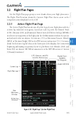
Страница 139: ... each leg with the Desired Track DTK Distance DIS and Estimated Time of Arrival ETA for the legs METARs are shown for waypoints in the flight plan In the Minimums window the source and selected value are shown See section 2 4 4 on Minimum Descent Altitude MDA or Decision Height DH in the PFD section and section 3 5 1 3 for more detail In the Active Leg Info box in the lower part of the display the...

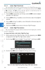
Страница 140: ...ess the INFO soft key if available to view information about the highlighted waypoint 3 Press the WX soft key if available to view XM weather information about the highlighted waypoint 4 Press the small MFD knob to return to the Active Flight Plan page 3 3 1 2 Active Flight Plan Options The Active Flight Plan page provides information for the flight plan currently in use for navigation To change d...

Страница 141: ...1 3 Setting the Altitude Minimums Alerter The Altitude Alerting function provides the pilot with visual and aural alerts if interfaced to an audio panel when approaching the Selected Altitude See 2 4 4 Minimum Descent Altitude Decision Height Alerting section of the PFD section for more details 1 While viewing the Charts Page of the FPL page group press the Menu key With the Set Minimums item high...

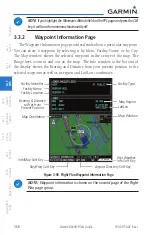
Страница 142: ...by Ident Facility Name or by City The Map window shows the selected waypoint in the center of the map The Range keys zoom in and out on the map The Info window at the bottom of the display shows the Bearing and Distance from your present position to the selected waypoint as well as its region and Lat Lon coordinates Facility Type Map Window Map Region Lat Lon Map Orientation Bearing Distance to Wp...

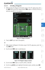
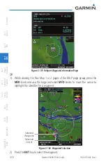
Страница 143: ... group press the MFD knob and use the large and small MFD knobs to move the cursor to select the identifier for the waypoint Figure 3 99 Waypoint Selection 2 Press the ENT key to select the waypoint OR 1 While viewing the Waypoint Information page of the FPL page group press the small MFD knob 2 Turn the small MFD knob counterclockwise Figure 3 100 Waypoint Category Selection 3 Turn the small MFD ...

Страница 144: ...8 Glossary Appendix A Appendix B Index Figure 3 101 Heliport Waypoint Information Page OR 1 While viewing the Nav Map 1 or 2 pages of the MAP page group press the MFD knob and use the large and small MFD knobs to move the cursor to highlight the identifier for a waypoint Selected Waypoint Selection Cursor Figure 3 102 Waypoint Selection 2 Press the ENT key to select the waypoint ...

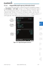
Страница 145: ...waypoint is available by pressing the RWY FREQ or APT DIR soft keys on the Waypoint Information page The current destination waypoint is the default item shown You may select a different Ident Facility or Location In the Runway window you may view information about the runways In the Frequency window a scroll bar is shown on the right side of the window when more frequencies are available Airport ...

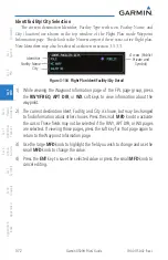
Страница 146: ...ess Public Private and Symbol Figure 3 104 Flight Plan Ident Facility City Detail 1 While viewing the Waypoint Information page of the FPL page group press the RWY FREQ APT DIR or WX soft keys to view information about the waypoint 2 The current destination Ident Facility and City is shown but may be changed to find information about other choices Press the small MFD knob to activate the cursor Th...

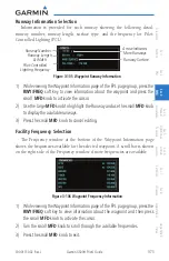
Страница 147: ...EQ soft key to view information about the waypoint and press the small MFD knob to activate the cursor 2 Use the large MFD knob to highlight the Runway and use the small MFD knob to display the available runways 3 Press the small MFD knob to cancel editing Facility Frequency Selection The Frequency window at the bottom of the Waypoint Information page shows the frequencies available for the select...

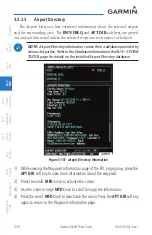
Страница 148: ...irport or heliport NOTE Airport Directory information comes from a database provided by various 3rd parties Refer to the Database information in theAUX SYSTEM STATUS page for details on the installed Airport Directory database Figure 3 107 Airport Directory Information 1 While viewing theWaypoint Information page of the FPL page group press the APT DIR soft key to view more information about the w...

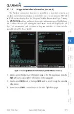
Страница 149: ... Waypoint Weather Information Page Pressing the WX NOTAM soft key will show the weather information page Highlighting the Product selection and turning the small MFD knob will display METAR data TAF information and NOTAMs as they are available NOTAMs are also available when FIS B is available Figure 3 108 Waypoint Weather Information Textual METARs and TAFs 1 While viewing theWaypoint Information ...

Страница 150: ...Sec 4 Hazard Avoidance Sec 5 Additional Features Sec 6 Annun Alerts Sec 7 Symbols Sec 8 Glossary Appendix A Appendix B Index 3 3 3 Charts Page Optional When the Chart function is available charts will be shown on the third page of the Flight Plan page group See Section 5 1 for more information ...

Страница 151: ...69A XM Satellite Weather Optional GFDS Weather with the Iridium satellite system through GSR 56 Optional FIS B Weather with the GDL 88H Optional Stormscope Optional 4 1 Terrain Configurations Garmin provides the following terrain awareness and alerting solutions within the G500H environment Terrain HSVT Refers to a subset of H TAWS that meets the terrain alerting requirements outlined in Section 7...

Страница 152: ...NS GTN HTAWS G500 600 GTN G500 600 GTN GNS GTN HTAWS Terrain SVT w 3rd party HTAWS 3rd party TAWS G500 600 HTAWS G500 600 G500 600 G500 600 G500 600 Table 4 1 G500H Terrain Annunciations HSVT Terrain Obstacle shading is only available when HSVT is enabled and displayed If the Garmin GPS TAWS is not available the G500 600 Terrain HSVT will generate PFD annunciator text and aural callouts An advisor...

Страница 153: ...imity Garmin Terrain Proximity is a non TSO C194 certified terrain awareness system provided as a standard feature of GDU 620 to increase situational awareness and help reduce controlled flight into terrain CFIT Terrain may be displayed on the Map page group Navigation Map and Terrain pages Terrain Proximity uses information provided from the GPS receiver to provide a horizontal position and altit...

Страница 154: ...roximity is not Terrain Proximity does not provide warning annunciations or voice alerts it only provides color indications on map displays when terrain and obstacles are within a certain altitude threshold from the aircraft Terrain HSVT is a non TSO C194 certified terrain awareness system Do not confuse Terrain HSVT with H TAWS H TAWS is TSO C194 certified and Terrain HSVT is not Terrain HSVT pro...

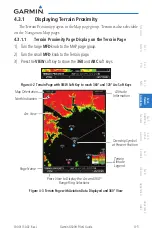
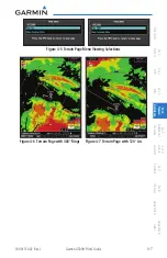
Страница 155: ...pages 4 3 1 1 Terrain Proximity Page Display on the Terrain Page 1 Turn the large MFD knob to the MAP page group 2 Turn the small MFD knob to the Terrain page 3 Press the VIEW soft key to show the 360 and ARC soft keys Figure 4 2 Terrain Page with VIEW Soft Key to reach 360 and 120 Arc Soft Keys Map Orientation North Indication Arc View Altitude Information Terrain Altitude Legend Ownship Symbol a...

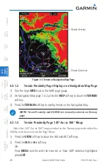
Страница 156: ...e MAP page group 2 On Navigation Map page 1 or 2 press the MAP soft key to show the TERRAIN soft key 3 Press the TERRAIN soft key to overlay terrain on the Navigation Map NOTE Terrain Proximity and NEXRAD are mutually exclusive on the map page 4 3 1 3 Terrain Proximity Page 120 Arc or 360 Rings Select the 120º Arc or 360º rings overlay for the Terrain page with either the 360 Arc soft keys or from...

Страница 157: ...em Sec 2 PFD Sec 3 MFD Sec 4 Hazard Avoidance Sec 5 Additional Features Sec 6 Annun Alerts Sec 7 Symbols Sec 8 Glossary Appendix A Appendix B Index Figure 4 5 Terrain Page Menu Viewing Selections Figure 4 6 Terrain Page with 360 Rings Figure 4 7 Terrain Page with 120 Arc ...

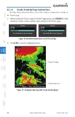
Страница 158: ...Page Aviation Data The Page Menu selections allow you to hide or show aviation data overlay on the Terrain page 1 While viewing the Terrain page of the MAP page group press MENU for Map selections to hide or show aviation data overlay on the Terrain page Figure 4 8 Show Hide Aviation Data on the Terrain Page 2 Press ENT to save the highlighted value Terrain Data Icon Terrain Overlay Figure 4 9 Nav...

Страница 159: ...tion is based on terrain elevation information in a database that may contain inaccuracies Terrain information should be used as an aid to situational awareness Never use it for navigation or to maneuver to avoid terrain Terrain uses terrain and obstacle information supplied by government sources The displayed information should never be understood as being all inclusive WARNING The data contained...

Страница 160: ...ase limitations No standardized recovery technique is defined as recovery maneuvers may vary The HTAWS shall NOT be used for navigation purposes H TAWS annunciations received from the GNS 400W 500W Series H TAWS unit will be displayed to the left and aligned with the top of the Altitude Tape on the G500H PFD A new annunciation will flash for approximately five seconds HTAWS annunciations can only ...

Страница 161: ...cle Clearance ROC Alerting Imminent Terrain Impact ITI Imminent Obstacle Impact IOI Alerting Terrain HSVT is available in G500H GDU 620 SW version 4 00 and later Terrain HSVT utilizes terrain and obstacle databases that are referenced to mean sea level MSL Using the GPS position and GPS MSL altitude Terrain HSVT displays a 2 D picture of the surrounding terrain and obstacles relative to the positi...

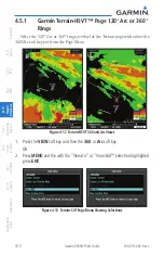
Страница 162: ...ndex 4 5 1 Garmin Terrain HSVT Page 120 Arc or 360 Rings Select the 120º Arc or 360º rings overlay for the Terrain page with either the 360 Arc soft keys or from the Page Menu Figure 4 12 Terrain HSVT 360 and Arc Views 1 Press the VIEW soft key and then the 360 or Arc soft key OR 2 Press MENU and the with the ViewArc or View 360 selection highlighted press ENT Figure 4 13 Terrain SVT Page Menu Vie...

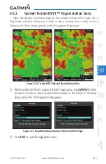
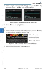
Страница 163: ...min Terrain HSVT page The Page Menu selections allow you to hide or show aviation data overlay on the Terrain or the Map Setup options for the Navigation Map pages Figure 4 14 Terrain HSVT Hide and Show Aviation Data 1 While viewing the Terrain page of the MAP page group press MENU for Map selections to hide or show aviation data overlay on the Terrain or the Map Setup options for the Navigation M...

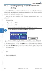
Страница 164: ... Terrain HSVT and always remember to enable the system when appropriate When Terrain HSVT is inhibited the following terrain alerts functions are inhibited Aural Alerts Pop up alert on MFD Annunciator on PFD Terrain warning and caution shading on PFD synthetic terrain NOTE See AFM for guidance on inhibiting Terrain HSVT Figure 4 16 Terrain HSVT Alerting Disabled Alerts Inhibited Annunciation PFD M...

Страница 165: ...ting thresholds and suppresses visual and aural annunciation of caution alerts Reduced protection allows low level operations and landings off airport with a minimum number of alerts while continuing to provide protection from terrain and obstacles Reduced Protection should only be selected when operating in visual contact with the terrain as alerting times are significantly less than in normal mo...

Страница 166: ...for Map selections to enable or disable RP Mode on the Terrain page Figure 4 19 Enable or Disable RP Mode on the Terrain HSVT Page 2 Press ENT to save the highlighted value OR 1 While viewing the Terrain page of the MAP page group press the RP soft key to enable or disable RP Mode on the Terrain page Press To Toggle RP Mode RP Mode Annunciation RP Mode Soft Key Label Figure 4 20 Enable or Disable ...

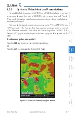
Страница 167: ...RP mode When an alert is issued visual annunciations are displayed and aural alerts are simultaneously issued When an alert is issued annunciations appear on the PFD and MFD Terrain HSVT page only The Terrain Alert Annunciation is shown to the upper left of the Altimeter on the PFD and below the Terrain Legend on the MFD If the Terrain HSVT page is not displayed at the time a pop up alert appears ...

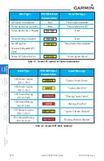
Страница 168: ...erting is disabled None No GPS position Excessively degraded GPS signal Terrain System Not Available Terrain SVT System Test Fail Terrain System Failure Table 4 3 Terrain SVT System Test Status Annunciations Alert Type PFD MFD Alert Annunciation Aural Message FLTA Terrain Caution RTC C ITI C Caution Terrain Terrain FLTA Terrain Caution RLC C ILI C Caution Wire Wire FLTA Terrain Warning RTC W ITI W...

Страница 169: ... B Index 4 5 6 Mute Caution Alerts Aural Caution Alert when present may be suppressed by pressing the MUTE CTN soft key or selecting Mute Caution Alerts from the Menu To Mute or Unmute Caution Alerts 1 When the MUTE CTN soft key label is present press the MUTE CTN key Aural Caution Alerts will be muted OR 2 Press the MENU key select Mute Caution Alerts and press ENT Figure 4 22 Mute and Unmute Cau...

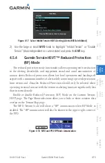
Страница 170: ... If the pilot desires to retain the Terrain warning shading on PFD synthetic terrain even when Terrain HSVT is inhibited then select the Enable SVT Terrain Alerts When Inhibited menu option To Enable or Disable SVT Terrain Alerts When Terrain Is Inhibited 1 While viewing theTerrain HSVT page of the MAP page group press the MENU key 2 Highlight Disable SVT Terrain Alerts When Inhibited and press EN...

Страница 171: ... 800 or 820 Skywatch 497 KTA 810 or other unit Coverage follows the aircraft In the Navigation Map page setup you can select the maximum range at which traffic symbols are shown Once outside of the selected range traffic will be decluttered The Traffic soft key will still be available The Garmin GDL 88H can provide TIS B and ADS B information The Garmin GTS ADS B products can also provide ADS B in...

Страница 172: ...y Aircraft is 5000 ft Above and Descending Range Ring Diameter Non Threat Traffic Proximity Advisory 1200 ft Above and Climbing Ownship Symbol Non Bearing Traffic System is Unable to Determine Bearing Aircraft Distance is 8 0 NM 1100 ft Above and Descending Figure 4 24 Traffic Map Page TAS TCAS 4 6 1 2 Switching from Standby Mode to Operating Modes The unit must be in operating mode for traffic to...

Страница 173: ...the RNG keys will zoom in and out in preset steps depending on the installed equipment 4 6 1 4 Altitude Display Changing the altitude display mode 1 Press the ALT MODE soft key to change the altitude filter 2 Select the desired altitude filter by pressing the BELOW NORMAL ABOVE or UNRSTD unrestricted soft keys The selection is displayed in the Altitude mode field Altitude Mode Displayed Traffic Ra...

Страница 174: ...Advisory Off Scale Table 4 6 TAS TCAS Traffic Symbol Description The traffic system determines the type of symbol used for each target Refer to the traffic system documentation for information regarding the criteria used to determine target type A Traffic Advisory TA alerts the crew to a potentially hazardous intruding aircraft Closing rate distance and vertical separation meet TA criteria for the...

Страница 175: ...also shown in white in center of page TAS Operating OPERATING TAS Standby STANDBY also shown in white in center of page Table 4 7 TAS TCAS Modes If the unit fails an annunciation as to the cause of the failure is shown in the center of the Traffic Map Page Traffic Map Page Annunciation Description NO DATA Data is not being received from the TAS unit TRFC FAIL TAS unit has failed unit is self repor...

Страница 176: ...ge TA X X XX System cannot determine bearing of Traffic Advisory Annunciation indicates distance in NM altitude separation in hundreds of feet and altitude trend arrow climbing descending TA X XNM XX System cannot determine bearing of Traffic Advisory Annunciation indicates distance in NM altitude separation in hundreds of feet and altitude trend arrow climbing descending The system distance units...

Страница 177: ...A Appendix B Index 4 6 1 7 Traffic Pop Up When the GDU 620 MFD is displaying any page other than the Traffic page and a traffic alert becomes active the Traffic pop up will be displayed NOTE The traffic pop up will not appear when your aircraft is on the ground Press ENT to go directly to the Traffic page OR Press CLR to return to the previously viewed page Traffic Pop Up Figure 4 25 Traffic Pop U...

Страница 178: ...isplay in the upper left corner of the MFD If Traffic Information Service TIS is configured TIS will be displayed in the upper left corner of the MFD Traffic Information Service TIS is designed to help in detection and avoidance of other aircraft TIS uses the Mode S transponder for the traffic data link TIS receives traffic information from ground stations and is updated every five seconds The GDU...

Страница 179: ...p Page Group 2 Turn the small MFD knob to select the Traffic Map Page 3 Confirm TIS is in Operating Mode Select the OPERATE soft key to begin displaying traffic OR 1 Press the MENU key 2 Select Operate Mode shown ifTIS is in Standby Mode and then press the ENT key Traffic Advisory Aircraft is 1200 feet above climbing and moving in the direction of the line Operating Mode Proximity Advisory Aircraf...

Страница 180: ...vides a vector line showing the direction in which the traffic is moving to the nearest 45º Traffic information for which TIS is unable to determine the bearing non bearing traffic is displayed in the bottom center of the Traffic Map Page or in a banner at the lower left corner of other map pages on which traffic can be displayed The altitude difference between the requesting aircraft and other in...

Страница 181: ... nor authorized as a direct result of a TIS intruder display or TIS advisory While TIS is a useful aid to visual traffic avoidance it has some system limitations that must be fully understood to ensure proper use Many of these limitations are inherent in secondary radar surveillance In other words the information provided by TIS will be no better than that provided to ATC TIS will only display air...

Страница 182: ...station uses a predictive algorithm in its tracking software This algorithm uses track history data to extrapolate intruders to their expected positions consistent with the time of display in the cockpit Occasionally aircraft maneuvering will cause this algorithm to induce errors in the display These errors primarily affect relative bearing information and traffic target track vector it will lag i...

Страница 183: ... generated As long as a single TA remains on the display no additional voice alerts are generated If a second TA appears on the display or if the number of TAs initially decreases and then subsequently increases another voice alert is generated A Traffic Not Available TNA voice alert is generated when the TIS service becomes unavailable or is out of range Traffic may not be displayed in the radar ...

Страница 184: ...ndix B Index 4 6 2 5 Traffic Pop Up When the GDU 620 MFD is displaying any page other than the NAV Traffic page and a traffic alert becomes active the Traffic Warning pop up will be displayed NOTE The traffic pop up will not appear when your aircraft is on the ground Press ENT to go directly to the Traffic page OR Press CLR to return to the previously viewed page Traffic Pop Up Figure 4 27 Traffic...

Страница 185: ...ata stream FAILED The transponder has failed UNAVAILABLE TIS is unavailable or out of range Contact a service center or Garmin dealer for corrective action Table 4 11 TIS Failure Annunciations The traffic mode is annunciated in the upper left corner of the Traffic Map Page When the aircraft is on the ground TIS automatically enters Standby Mode If traffic is selected for display on another map whi...

Страница 186: ...iations indicate the status of traffic information appear in a banner at the lower left corner of maps on which traffic can be displayed Traffic Status Banner Annunciation Description TA OFF SCALE A Traffic Advisory is outside the selected display range Annunciation is removed when traffic comes within the selected display range TA X XNM XX System cannot determine bearing of Traffic Advisory Annun...

Страница 187: ...has not been detected TRFC UNAVAIL The traffic service is unavailable or out of range Shown as symbol on Traffic Map Page Shown in center of Traffic Map Page Table 4 13 TIS Traffic Status Annunciations 4 6 3 ADS B Traffic Optional ADS B In allows a properly equipped aircraft to receive TIS B and other aircraft equipped with ADS B out capability Below Normal Above Unrestricted Back Alt Mode Absolut...

Страница 188: ...o step through selection of the available targets 3 After selecting a target you can press the small MFD knob to leave the target selected and return the small MFD to page selection mode 4 Use the DESELECT softkey to turn off selected traffic Selected Traffic Info ADS B and TCAS Status and Altitude Filter Selected Vector Motion and Duration Turn Cursor Knob for Next Target Map Orientation Range Ri...

Страница 189: ... Alerted Traffic Directional Alerted Traffic Off Scale Directional Alerted Traffic Non Directional Surface Vehicle Directional Surface Vehicle Table 4 20 ADS B Traffic Symbols NOTE Color of basic and proximate traffic is dependent on airborne on ground status of target target is brown when on the ground see the surface vehicles 4 6 3 2 Status ADS B Status ADS B Status displays the current status o...

Страница 190: ...ck and ground speed and your aircraft s track and ground speed These two values are combined to depict where the traffic target is moving with respect to your aircraft and indicates where the traffic target will be relative to your aircraft at the time specified by the length of the vector NOTE Absolute motion vectors match the color of the intruder white or yellow Relative motion vectors are gree...

Страница 191: ...tion will result in a longer vector Press the smart key for the desired duration Altitude Filter The Altitude Filter limits the traffic displayed to the Below Normal Above or Unrestricted altitude block as listed in the Displayed Traffic Range table The filter altitudes are relative to ownship altitude Press the Alt Mode smart key to display the altitude smart keys Press the smart key to select th...

Страница 192: ...cts When a weather product is active on the Weather Data Link Page or the Navigation Map Page the age of the data is displayed on the screen The age of the product is based on the time difference between when the data was assembled on the ground and the current GPS time Weather products are refreshed at specific intervals defined in the Refresh Rate column If a weather product is not received with...

Страница 193: ...e viewing a WX Data Link Map page of the WX page group press the MENU key to display the Page Menu Options The cursor flashes on the Weather Setup option Press ENT Figure 4 28 Weather Page Menu Options 2 Turn the Large or Small MFD knob to select Weather Setup 1 2 or Weather Setup 2 2 and press ENT Figure 4 29 Weather Setup Group Selection 3 With the Data Link Setup Menu displayed turn the Large M...

Страница 194: ...ng Data Viewing Range Off 10 NM to 500 NM Cell Mov Data Viewing Range Off 10 NM to 500 NM SIG AIR Viewing Range Off 10 NM to 500 NM PIREPS Data Viewing Range Off 10 NM to 500 NM METAR Data Viewing Range Off 10 NM to 500 NM Surface Data Viewing Range Off 10 NM to 500 NM Frz Lvl Data Viewing Range Off 10 NM to 500 NM Wnds Aloft Data Viewing Range Off 10 NM to 500 NM County Data Viewing Range Off 10 ...

Страница 195: ...r Weather data is updated at intervals that are defined and controlled by XM WX Satellite Radio and its data vendors The product label in the legend will turn yellow at half the expiration time and grey when expired Expired products will not be shown on the display WARNING Do not use data link weather information for maneuvering in near or around areas of hazardous weather Information contained wi...

Страница 196: ...s 90 City Forecast 90 Surface Analysis 60 Freezing Levels 120 Winds Aloft 90 County Warnings 60 PIREPS 90 TFRs 60 AIREPS 90 Icing 90 Turbulence 180 Cyclone Warnings 60 Table 4 15 Weather Product Symbols and Data Timing NOTE Product age for individual reports of XM AIRMETs SIGMETs City Forecasts County Warnings Cell Movement and TFRs are not provided by XM Weather Service Product age indication for...

Страница 197: ...h Low Temp Table 4 16 Weather Symbols 4 7 4 XM Weather Legends The LEGEND soft key displays a pop up legend of the currently used weather products Pressing the LEGEND soft key again the MFD knob the ENT or CLR keys will remove the legend 1 A full page legend can be selected by selecting the Weather Legend option in the XM Weather Map Menu or pressing the LEGEND soft key on the Weather Map Page The...

Страница 198: ...min G500H Pilot s Guide 190 01150 02 Rev J Foreword Sec 1 System Sec 2 PFD Sec 3 MFD Sec 4 Hazard Avoidance Sec 5 Additional Features Sec 6 Annun Alerts Sec 7 Symbols Sec 8 Glossary Appendix A Appendix B Index ...

Страница 199: ...ed by the National Weather Service NWS NEXRAD data provides centralized meteorological information for the continental United States and selected overseas locations The maximum range of a single NEXRAD radar site is 250 NM The NEXRAD network provides important information about severe weather for air traffic safety NEXRADdataisnotreal time Thelapsedtimebetweencollection processing and disseminatio...

Страница 200: ...eather NEXRAD CompositedatafromalltheNEXRADradarsitesintheUnitedStatesisshown This data is composed of the maximum reflectivity from the individual radar sweeps The display of the information is color coded to indicate the weather severity level All weather product legends can be viewed on the Weather Data Link Page For the NEXRAD legend select the LEGEND soft key when NEXRAD is selected for displ...

Страница 201: ...et and dry hail can be extremely hazardous The different NEXRAD echo intensities are measured in decibels dB relative to reflectivity Z NEXRAD measures the radar reflectivity ratio or the energy reflected back to the radar receiver designated by the letter Z The value of Z increases as the returned signal strength increases 4 7 5 2 NEXRAD Limitations NEXRAD radar images may have certain limitation...

Страница 202: ...nge the highlighted value Figure 4 34 Weather Page Map Orientation 4 Press ENT to accept the displayed value The next option will be highlighted 5 Press the small MFD knob to cancel selection or to end editing and return to the Navigation Map page or turn the large MFD knob to the next option 4 7 7 NEXRAD Data Viewing Range The NEXRAD Viewing Range option allows you to select the map range where a...

Страница 203: ... the previously viewed page or turn the large MFD knob to the next option 4 7 8 NEXRAD Legend The NEXRAD Legend selection provides the option of displaying an abbreviated version of the NEXRAD legend in the top right region of the MFD The full legend is available by pressing the LEGEND soft key Figure 4 35 NEXRAD Legend Selection 1 While viewing Weather Setup 1 2 menu turn the large MFD knob to hi...

Страница 204: ... Sec 8 Glossary Appendix A Appendix B Index 4 7 9 NEXRAD Source The NEXRAD Legend selection provides the option of using US or Canadian Nexrad data Figure 4 36 NEXRAD Source Selection 1 While viewing Weather Setup 1 2 menu turn the large MFD knob to highlight the NEXRAD Legend value 2 Turn the small MFD knob to highlight US or Canada Press ENT to accept the displayed value ...

Страница 205: ...d NEXRAD Echo Tops data shows the location elevation and direction of the highest radar echo The highest radar echo does not indicate the top of a storm or clouds rather it indicates the highest altitude at which precipitation is detected Information is derived from NEXRAD data Figure 4 37 XM Weather Echo Tops The display of radar coverage is always active when either NEXRAD or ECHO TOPS is select...

Страница 206: ...d MFD Wx Data Link Map page 1 2 or 3 When Off is selected Echo Tops will not be shown Where a value such as 250 NM is selected Echo Top data will be shown at map ranges of the selected value 250 NM and lower 1 While viewing Weather Setup 1 2 menu turn the large MFD knob to highlight the Echo Top Data Viewing Range value 2 Turn the small MFD knob to highlight the desired value Press ENT to accept t...

Страница 207: ...display of Cloud Tops is mutually exclusive with Echo Tops and NEXRAD Cloud Tops data depicts cloud top altitudes as determined from satellite imagery Figure 4 38 XM Weather Cloud Tops To display the Cloud Tops legend select the LEGEND soft key when Cloud Tops is selected for display Since Cloud Tops and Echo Tops use the same color scaling to represent altitude display of these weather products i...

Страница 208: ...ected MFD Wx Data Link Map page 1 2 or 3 When Off is selected Cloud Tops will not be shown Where a value such as 150 NM is selected Cloud Top data will be shown at map ranges of that value 150 NM and lower 1 While viewing Weather Setup 1 2 menu turn the large MFD knob to highlight the Cloud Top Data Viewing Range value 2 Turn the small MFD knob to highlight the desired value Press ENT to accept th...

Страница 209: ...ng Data Viewing Range option allows you to select the map range where at and below that value Lightning weather products will be shown on the selected MFD Wx Data Link Map page 1 2 or 3 When Off is selected Lightning will not be shown Where a value such as 100 NM is selected NEXRAD data will be shown at map ranges of the selected value 100 NM and lower 1 While viewing Weather Setup 1 2 menu turn t...

Страница 210: ...nsidered of importance to aircraft A Convective SIGMET is issued for hazardous convective weather A localized SIGMET is a significant weather condition occurring at a localized geographical position When enabled SIGMET AIRMETs advise the pilot of potentially hazardous weather to all aircraft SIGMET AIRMET data covers icing turbulence dust and volcanic ash as issued by the National Weather Service ...

Страница 211: ...d lower 1 While viewing Weather Setup 1 2 menu turn the large MFD knob to highlight the SIG AIR Viewing Range value 2 Turn the small MFD knob to highlight the desired value Press ENT to accept the displayed value The next option will be highlighted 3 Press the small MFD knob to cancel selection or to end editing and return to the previously viewed page or turn the large MFD knob to the next option...

Страница 212: ...es are required to solicit PIREPs A PIREP may contain non forecast adverse weather conditions such as low in flight visibility icing conditions wind shear and turbulence PIREPs are issued as either Routine UA or Urgent UUA Figure 4 42 XM Weather PIREPs 1 While viewing Weather Setup 1 2 menu turn the large MFD knob to highlight the PIREPs value 2 Turn the small MFD knob to highlight the desired val...

Страница 213: ...dard format for current weather observations METARs are updated hourly and are considered current METARs typically contain information about the temperature dew point wind precipitation cloud cover cloud heights visibility and barometric pressure They can also contain information on precipitation amounts lightning and other critical data METARs are shown as colored flags at airports that provide t...

Страница 214: ...el selection or to end editing and return to the previously viewed page or turn the large MFD knob to the next option Viewing Textual METARs Textual METARs can be viewed by selecting an airport on the Map or Weather WX pages 1 While viewing a Map or Weather page Use the small and large MFD knobs to move the cursor to highlight an airport with a METAR flag Press ENT 2 The Waypoint Information page ...

Страница 215: ...t weather products will be shown on the selected MFD Wx Data Link Map page 1 2 or 3 Altitude can be selected in 3000 foot increments from the surface up to 42 000 feet MSL ALT UNAVBL is displayed when the altitude is unsupported for a specific product and will never show data on the map Pressing the WX Alt Dn or WX Alt Up soft keys steps down or up in the 3 000 foot increments In the figure below ...

Страница 216: ... MFD Wx Data Link Map page 1 2 or 3 When Off is selected Winds Aloft will not be shown Where a value such as 100 NM is selected Winds Aloft data will be shown at map ranges of the selected value 100 NM and lower 1 While viewing Weather Setup 1 2 menu turn the large MFD knob to highlight the Winds Aloft Data Viewing Range value 2 Turn the small MFD knob to highlight the desired value Press ENT to a...

Страница 217: ...48 hours by pressing the SRFC TIME soft key or in the Page Menu Weather Setup options When enabled the Surface Analysis forecast shows frontal lines indicat ing weather fronts and the direction they are moving High and Low pressure centers are noted with a large H or L The Forecast Time menu item will step through the intervals manually Figure 4 47 XM Weather Surface Analysis and City Forecast A C...

Страница 218: ...that value Surface Data weather products will be shown on the selected MFD Wx Data Link Map page 1 2 or 3 When Off is selected Surface Data will not be shown Where a value such as 150 NM is selected Surface data will be shown at map ranges of the selected value 150 NM and lower 1 While viewing Weather Setup 1 2 menu turn the large MFD knob to highlight the Surface Data Viewing Range value 2 Turn t...

Страница 219: ...y Data Viewing Range option allows you to select the map range where at and below that value County weather products will be shown on the selected MFD Wx Data Link Map pages 1 2 or 3 When Off is selected County Data will not be shown Where a value such as 100 NM is selected County data will be shown at map ranges of the selected value 100 NM and lower 1 While viewing Weather Setup 1 2 menu turn th...

Страница 220: ...ge option selects whether TFR information is shown on the GFDS Weather Map TFR information will be shown at and below the selected map range When Off is selected the information will not be shown For the value such as 500 NM selected TFR information will be shown at map ranges of that value 500 NM and lower 1 While viewing Weather Setup 1 2 menu turn the large MFD knob to highlight the TFR Data Vi...

Страница 221: ...x A Appendix B Index Viewing Textual TFRs Textual TFRs can be viewed by selecting a TFR outline on the Weather WX pages 1 While viewing a XM Weather page Use the small and large MFD knobs to move the cursor to highlight a TFR symbol yellow circle Press ENT 2 The TFR details will be shown 3 Press the small MFD knob or ENT to return to the Weather page Figure 4 54 XM Weather Textual TFRs and Legend ...

Страница 222: ... XM Cell Movement Cell Movement data shows the location and movement of storm cells as identified by a ground based system Cells are represented by yellow squares with direction of movement indicated with short orange arrows Figure 4 55 XM Weather Cell Movement On most applicable maps Cell Movement data is selected for display along with NEXRAD On the Weather Data Link Page Cell Movement data can ...

Страница 223: ... as 100 NM is selected Cell Movement data will be shown at map ranges of the selected value 100 NM and lower 1 While viewing a WX Data Link Map page of the WX page group press the MENU key to display the Page Menu Options The cursor flashes on the Weather Setup option Press ENT 2 Turn the small MFD knob to select Weather Setup 2 2 and press ENT 3 Turn the large MFD knob to highlight the Cell Movem...

Страница 224: ...from commercia aircraft to a ground station AIREPs are similar to PIREPs 1 While viewing Weather Setup 2 2 menu turn the large MFD knob to highlight the AIREPs Viewing Range option 2 Turn the small MFD knob to highlight the desired value Press ENT to accept the displayed value The next option will be highlighted 3 Press the small MFD knob to cancel selection or to end editing and return to the pre...

Страница 225: ...endix A Appendix B Index Viewing Textual AIREPs PIREPs Textual AIREPs PIREPs can be viewed by selecting a AIREP on the Map or Weather WX pages 1 While viewing a Map or Weather page Use the small and large MFD knobs to move the cursor to highlight an airport with a AIREP 2 Press ENT to view text information Press ENT again to return to the previous page Figure 4 57 XM Weather AIREP Text Detail ...

Страница 226: ...ith the date and time 1 While viewing Weather Setup 2 2 menu turn the large MFD knob to highlight the Cyclone Data Viewing Range option 2 Turn the small MFD knob to highlight the desired value Press ENT to accept the displayed value The next option will be highlighted 3 Press the small MFD knob to cancel selection or to end editing and return to the previously viewed page or turn the large MFD kno...

Страница 227: ...s you to select the map range where at and below that value Freezing Level weather products will be shown on the selected MFD Wx Data Link Map page 1 2 or 3 When Off is selected Freezing Level Data will not be shown Where a value such as 100 NM is selected Freezing Level data will be shown at map ranges of the selected value 100 NM and lower 1 While viewing a WX Data Link Map page of the WX page g...

Страница 228: ...cative of freezing drizzle and freezing rain aloft SLD threat areas are depicted as black and red blocks over the Icing colors Icing and SLD data are shown between 1 000 feet and 30 000 feet in 3 000 foot increments 1 While viewing Weather Setup 2 2 menu turn the large MFD knob to highlight the Icing Data Viewing Range value 2 Turn the small MFD knob to highlight the desired value Press ENT to acc...

Страница 229: ...et Turbulence data is intended to supplement AIRMETs and SIGMETs 1 While viewing Weather Setup 2 2 menu turn the large MFD knob to highlight the Turbulence Viewing Range value 2 Turn the small MFD knob to highlight the desired value Press ENT to accept the displayed value The next option will be highlighted 3 Press the small MFD knob to cancel selection or to end editing and return to the previous...

Страница 230: ...eather coverage is available throughout most of Europe Canada and the U S Additional radar coverage areas are being added continuously More detail on GFDS weather products and coverage can be found at http fly garmin com fly garmin gfds weather NOTE A system can be configured for both XM and GFDS but both cannot be displayed a the same time WARNING Do not use data link weather information for mane...

Страница 231: ...e viewing a WX Data Link Map page of the WX page group press the MENU key to display the Page Menu Options Turn the large MFD knob to highlight the Display GFDSWeather option Press ENT This setting will affect the display of data link weather on the map pages as well as the Wx pages Figure 4 61 Select GFDS Weather 2 Select XM Weather by repeating the process and selecting the XM Weather option Fig...

Страница 232: ...me info model tail number etc 2 Customer Service will issue an access code to enter on the GFDS Registration page 3 While viewing a WX Data Link Map page of the WX page group press the MENU key to display the Page Menu Options 4 Turn the large MFD knob to highlight Register With GFDS Press ENT Figure 4 63 Select GFDS Registration 5 Turn the small MFD knob to select values and the large MFD knob to...

Страница 233: ...With GFDS Registration of the GDU unit with GFDS can be deactivated so that the unit can no longer make requests to GFDS This does not cancel the subscription 1 While viewing a WX Data Link Map page of the WX page group press the MENU key to display the Page Menu Options 2 Turn the large MFD knob to highlight Register With GFDS Press ENT 3 With the Access Code field highlighted press CLR to remove...

Страница 234: ...considered expired and is removed from the display This ensures that the displayed data is consistent with what is currently being broadcast by GFDS Satellite Radio services If more than half of the expiration time has elapsed from the time the data is received the color of the product age displayed changes to yellow 4 8 3 Customizing the GFDS Weather Map Each Wx Data Link Map page may be customiz...

Страница 235: ...Appendix B Index 2 With the Data Link Setup Menu displayed turn the Large MFD knob to select the desired item Figure 4 66 Weather Data Link Setup Menu Options 3 Turn the small MFD knob to select the desired weather feature option 4 Press ENT to save a selection 5 Turn the large MFD knob to the next desired option or press the small MFD knob to cancel and return to the GFDS Weather Data Link Map Pa...

Страница 236: ...iewing Range Off 10 NM to 500 NM Wnd Aloft Data Viewing Range Off 10 NM to 500 NM TFR Data Viewing Range Off 10 NM to 500 NM Table 4 17 GFDS Weather Page Menu Setup Options 4 8 4 Weather Page Map Orientation The Orientation option sets the orientation of the Wx Data Link Map pages 1 While viewing theWx Data Link Map 1 2 or 3 of theWx page group press the MENU key With Weather Setup highlighted pre...

Страница 237: ...est the downloading of weather products Requests can be sent manually or set to automatically update at a selected rate 1 While viewing a WX Data Link Map page of the WX page group press the MENU key to display the Page Menu Options 2 Turn the large MFD knob to highlight GFDS Data Request Press ENT Figure 4 68 Select GFDS Data Request 3 Turn the small MFD knob to select values and the large MFD kn...

Страница 238: ...Position box will be checked and weather information will be requested around your present position 5 To deselect Present Position reporting turn the large MFD knob to highlight Present Position Press ENT Destination GFDS Data Request 1 Turn the large MFD knob to highlight Destination Press ENT 2 The Destination box will be checked and weather information will be requested around your flight plan ...

Страница 239: ...4 To deselect Flight Plan reporting turn the large MFD knob to highlight Flight Plan Press ENT Waypoint GFDS Data Request 1 Turn the large MFD knob to highlight Waypoint Press ENT 2 TheWaypoint Selection field will now be highlighted Turn the small MFD knob to select the first character Turn the large MFD knob to highlight the next character When finished selecting the waypoint name press ENT Figu...

Страница 240: ... section the Diameter Route Width field will now be highlighted Figure 4 72 Waypoint GFDS Data Request Range 2 Turn the small MFD knob to select the desired Diameter RouteWidth and then press ENT 4 8 5 2 GFDS Data Request Auto Request 1 Turn the large MFD knob to highlight Auto Request Update Rate 2 Turn the small MFD knob to select Off or an Update Rate When finished selecting the Update Rate pre...

Страница 241: ...uests are made some products are merged with the old data SIGMETs AIRMETs TAFs TFRs and METARs but the old data of other products is discarded 1 Turn the large MFD knob to highlight Manual Request Send Req 2 Press ENT Figure 4 74 Manual GFDS Data Request 3 The update request will occur immediately The action will be noted in the Request Status window The Auto Request time will be reset to the sele...

Страница 242: ...is selected PRECIP data will be shown at map ranges of 500 NM and lower TFRs and METARs are the only weather products shown below 10 NM Area Of No Coverage Coverage Boundary Figure 4 75 GFDS PRECIP Weather Map Display and Legend 1 While viewing a WX Data Link Map page of the WX page group press the MENU key to display the Page Menu Options Turn the large MFD knob to highlight the Weather Setup opt...

Страница 243: ...s available by pressing the LEGEND soft key Figure 4 76 GFDS PRECIP Legend Selection 1 While viewing a WX Data Link Map page of the WX page group press the MENU key to display the Page Menu Options Turn the large MFD knob to highlight the Weather Setup option and press ENT 2 Turn the large MFD knob to highlight PRECIP Legend 3 Turn the small MFD knob to highlight Off or On Press ENT to accept the ...

Страница 244: ... where at and below that value IR SAT weather products will be shown on the selected MFD GFDS Weather Map page 1 2 or 3 When Off is selected IR SAT will not be shown For the selected value such as 250 NM is selected IR SAT data will be shown at map ranges of the selected value 250 NM and lower 1 While viewing a WX Data Link Map page of the WX page group press the MENU key to display the Page Menu ...

Страница 245: ...ng Data Viewing Range option allows you to select the map range where at and below that value Lightning weather products will be shown on the selected MFD GFDS Weather Map page 1 2 or 3 When Off is selected Lightning will not be shown Where a value such as 250 NM is selected GFDS data will be shown at map ranges of the selected value 250 NM and lower 1 While viewing a GFDS Weather Map page of the ...

Страница 246: ...or On AIRMET SIGMET Line MTN Obscures Visibility Product Age Cursor Location Icing Localized SIGMET Figure 4 79 GFDS Weather Page AIRMETs SIGMETs When enabled SIGMET AIRMETs advise the pilot of potentially hazardous weather to all aircraft SIGMET AIRMET data covers icing turbulence dust and volcanic ash as issued by the National Weather Service The update rate is every 12 minutes in the U S Elsewh...

Страница 247: ...ill be shown on the selected MFD Wx Data Link Map page 1 2 or 3 When Off is selected SIGMET AIRMET will not be shown Where a value such as 250 NM is selected SIGMET AIRMET data will be shown at map ranges of the selected value 250 NM and lower 1 While viewing a WX Data Link Map page of the WX page group press the MENU key to display the Page Menu Options Turn the large MFD knob to highlight the We...

Страница 248: ... flight visibility icing conditions wind shear and turbulence PIREPs are issued as either Routine UA or Urgent UUA PIREP Detail Product Age Cursor Location Selected PIREP Figure 4 81 GFDS Weather Page AIREPs PIREPs 1 While viewing a WX Data Link Map page of the WX page group press the MENU key to display the Page Menu Options The cursor flashes on the Weather Setup option Press ENT 2 Turn the larg...

Страница 249: ...Ps PIREPs Textual AIREPs PIREPs can be viewed by selecting an AIREP PIREP on the Map or Weather WX pages 1 While viewing a Map or Weather page Use the small and large MFD knobs to move the cursor to highlight an airport with an AIREP PIREP Press ENT 2 The Waypoint Information page for that airport will now be shown Press the WX soft key to view weather information for the waypoint Figure 4 82 GFDS...

Страница 250: ...abase service area METAR METeorological Aerodrome Report known as an Aviation Routine Weather Report is the standard format for current weather observations METARs are generally updated hourly but some site are more frequent Special updates are done as conditions warrant METARs typically contain information about the temperature dew point wind precipitation cloud cover cloud heights visibility and...

Страница 251: ...g Textual METARs Textual METARs can be viewed by selecting an airport on the Map or Weather WX pages 1 While viewing a Map or Weather page Use the small and large MFD knobs to move the cursor to highlight an airport with a METAR flag Press ENT 2 The Waypoint Information page for that airport will now be shown Press the WX soft key to view weather information for the waypoint Figure 4 84 GFDS Weath...

Страница 252: ...l not be shown Where a value such as 150 NM is selected METAR data will be shown at map ranges of the selected value 150 NM and lower 1 While viewing a WX Data Link Map page of the WX page group press the MENU key to display the Page Menu Options Turn the large MFD knob to highlight the Weather Setup option and press ENT 2 Turn the large MFD knob to highlight METAR Data Viewing Range 3 Turn the sm...

Страница 253: ...oft data shows the forecast wind speed and direction at the surface and at selected altitudes Altitudes can be selected in 3000 foot increments from the surface up to 42 000 feet MSL Pressing the WX Alt Dn or WX Alt Up soft keys steps down or up in 3 000 foot increments Selected Altitude Present Position Product Age Winds Aloft Altitude Soft Keys Winds Aloft Symbol Figure 4 85 GFDS Weather Winds A...

Страница 254: ...is selected Winds Aloft will not be shown When 150 NM is selected Winds Aloft data will be shown at map ranges of 150 NM and lower 1 While viewing a WX Data Link Map page of the WX page group press the MENU key to display the Page Menu Options Turn the large MFD knob to highlight the Weather Setup option and press ENT 2 Turn the large MFD knob to highlight Winds Aloft Data Viewing Range 3 Turn the...

Страница 255: ...light Restriction TFR viewing range option selects whether TFR information is shown on the GFDS Weather Map TFR information will be shown at and below the selected map range When Off is selected the information will not be shown For the value such as 500 NM selected TFR information will be shown at map ranges of that value 500 NM and lower 1 While viewing a GFDSWeather Map page of theWX page group...

Страница 256: ...A Appendix B Index Viewing Textual TFRs Textual TFRs can be viewed by selecting a TFR outline on the Weather WX pages 1 While viewing a GFDS Weather page Use the small and large MFD knobs to move the cursor to highlight a TFR symbol yellow circle Press ENT 2 The TFR details will be shown 3 Press the small MFD knob or ENT to return to the Weather page Figure 4 88 GFDS Weather Textual TFRs and Legen...

Страница 257: ...e are possible abnormalities regarding displayed NEXRAD images Some but not all causes of abnormal displayed information include Ground Clutter Strobes and spurious radar data Sun strobes when the radar antenna points directly at the sun Military aircraft deploy metallic dust which can cause alterations in radar scans Interference from buildings or mountains which may cause shadows Scheduled maint...

Страница 258: ...on of the color code The NEXRAD option has selections of Regional CONUS or Combined NEXRAD CONUS NEXRAD includes a composite of available NEXRAD radar imagery across the 48 states Regional NEXRAD is a composite of available NEXRAD radar imagery in a local area showing a more detailed image than CONUS NEXRAD FIS B weather data reception requires line of site communication between the receiver and t...

Страница 259: ... knob to cancel selection or to end editing and return to the Navigation Map page or turn the large MFD knob to the next option 4 9 5 2 NEXRAD Data Viewing Range The NEXRAD Viewing Range option allows you to select the map range where at and below the selected value NEXRAD weather products will be shown on the selected MFD FIS B Weather Map page 1 2 or 3 When Off is selected NEXRAD weather data wi...

Страница 260: ... the top right region of the MFD The full legend is available by pressing the LEGEND soft key 1 While viewing a FIS B Weather Map page of the WX page group press the MENU key to display the Page Menu Options The cursor flashes on the Weather Setup option Press ENT 2 Turn the large MFD knob to highlight the NEXRAD Legend value 3 Turn the small MFD knob to highlight Off or On Press ENT to accept the...

Страница 261: ... 1 While viewing the FIS B weather page press the Menu key 2 With the Weather Setup selection highlighted press ENT 3 Turn the large MFD knob to highlight the NEXRAD DataViewing Range Source option 4 Turn the small MFD knob to select the desired Source option and press ENT Continental US NEXRAD CONUS The Display CONUS NEXRAD selection shows NEXRAD radar information for the entire continental Unite...

Страница 262: ...voidance Sec 5 Additional Features Sec 6 Annun Alerts Sec 7 Symbols Sec 8 Glossary Appendix A Appendix B Index Regional NEXRAD The Regional NEXRAD selection shows available regional NEXRAD radar information from reporting ground stations within 500 NM of the aircraft location Figure 4 92 FIS B Regional NEXRAD ...

Страница 263: ...NM Regional Boundary CONUS Data Area Figure 4 93 FIS B Combined NEXRAD 4 9 5 5 SIGMETs and AIRMETs SIG AIR SIGMETs SIGnificant METeorological Information and AIRMETs AIRmen s METeorological Information are broadcast for potentially hazardous weather considered of importance to aircraft A Convective SIGMET is issued for hazardous convective weather A localized SIGMET is a significant weather condit...

Страница 264: ...shown on the selected MFD FIS B Weather Map page 1 2 or 3 When Off is selected SIGMET AIRMET will not be shown For a value selected such as 150 NM SIGMET AIRMET data will be shown at map ranges of that value 150 NM and lower 1 While viewing a FIS B Weather Map page of the WX page group press the MENU key to display the Page Menu Options The cursor flashes on the Weather Setup option Press ENT 2 Tu...

Страница 265: ... selecting an SIGMET AIRMET line on the Map or Weather WX pages 1 While viewing a Map or Weather page Use the small and large MFD knobs to move the cursor to highlight a SIGMET AIRMET line Press ENT 2 The Waypoint Information page for that line will now be shown Press the WX soft key to view weather information Figure 4 95 FIS B AIRMETs SIGMETs Detail and Legend When enabled the following AIRMETs ...

Страница 266: ... low in flight visibility icing conditions wind shear and turbulence PIREPs are issued as either Routine UA or Urgent UUA 1 While viewing a FIS B Weather Map page of the WX page group press the MENU key to display the Page Menu Options The cursor flashes on the Weather Setup option Press ENT 2 Turn the large MFD knob to highlight the PIREPS Viewing Range value 3 Turn the small MFD knob to highligh...

Страница 267: ...endix A Appendix B Index Viewing Textual AIREPs PIREPs Textual AIREPs PIREPs can be viewed by selecting an AIREP PIREP on the Map or Weather WX pages 1 While viewing a Map or Weather page Use the small and large MFD knobs to move the cursor to highlight a AIREP PIREP Press ENT 2 Press ENT or the the small MFD knob to return to the Weather page Figure 4 97 FIS B AIREPs PIREPs Detail and Legend ...

Страница 268: ...or current weather observations METARs are updated hourly and are considered current METARs typically contain information about the temperature dew point wind precipitation cloud cover cloud heights visibility and barometric pressure They can also contain information on precipitation amounts lightning and other critical data METARs are shown as colored flags at airports that provide them Selected ...

Страница 269: ... knob to highlight the desired value Press ENT to accept the displayed value The next option will be highlighted 4 Press the small MFD knob to cancel selection or to end editing and return to the Navigation Map page or turn the large MFD knob to the next option Viewing Textual METARs Textual METARs can be viewed by selecting an airport on the Map or Weather WX pages 1 While viewing a Map or Weathe...

Страница 270: ... below that value Winds Aloft weather products will appear on the selected MFD FIS B Weather Map page 1 2 or 3 When Off is selected Winds Aloft will not be shown For the value such as 150 NM selected Winds Aloft data will be shown at map ranges of that value such as 150 NM and lower 1 While viewing a FIS B Weather Map page of the WX page group press the MENU key to display the Page Menu Options Th...

Страница 271: ...ewing range option selects whether TFR information is shown on the FIS B Weather Map TFR information will be shown at and below the selected map range When Off is selected the information will not be shown For the value such as 500 NM selected TFR information will be shown at map ranges of that value 500 NM and lower 1 While viewing a FIS BWeather Map page of theWX page group turn the large MFD kn...

Страница 272: ...e TFR will be shown and the first TFR will be highlighted In the case of multiple TFRs turn the small or large MFD knobs to highlight the desired TFR 3 Press the VIEW TEXT soft key to view the full TFR text 4 Press ENT to return to the Weather page Figure 4 102 FIS B Weather Textual TFRs and Legend 4 9 6 FIS B Product Times The weather product expiration time is shown in the following table It doe...

Страница 273: ...r avoidancesystemthatdetectselectricaldischargesassociatedwiththunderstorms within a 200 NM radius of the aircraft StormScope measures relative bearing and distance of thunderstorm related electrical activity and reports the information to the display Interfaces are currently only available for the WX 500 StormScope System For lightning display interpretation study the examples in the WX 500 Pilot...

Страница 274: ...cell data during these periods frees the user from sifting through a screen full of discharge points and helps to better determine where the storm cells are located View The Mode selection allows you to select 360 or Arc views Clearing the StormScope Page Routinely clearing the StormScope Page of all discharge points is a good way to determine if a storm is building or dissipating In a building st...

Страница 275: ...nic terminal procedures charts Electronic charts offer the convenience of rapid access to essential information Either ChartView or FliteCharts may be configured in the system SafeTaxi diagrams provide detailed taxiway runway and ramp information at more than 700 airports in the United States By decreasing the range on an airport that has a SafeTaxi diagram available a close up view of the airport...

Страница 276: ... charts aboard the aircraft See the AFMS for more information NOTE The Chart feature provides a digital representation of a paper chart and provides no vertical or lateral course guidance Flight Plan and Procedures are separate from Charts and do provide vertical and lateral course guidance for the loaded route or procedure shown on the Flight Plan page The term Chart Unavailable means that the ch...

Страница 277: ...he Flight Plan FPL page group 2 Turn the small MFD knob to the Charts page 5 1 1 ChartView Optional ChartView resembles the paper version of Jeppesen terminal procedures charts The charts are displayed in full color with high resolution The MFD depiction shows the aircraft position on the moving map in the plan view of approach charts and on airport diagrams The ChartView database subscription is ...

Страница 278: ...ata may also be provided by sources other than the FAA The charts are displayed with high resolution and in color for applicable charts The MFD FliteCharts depiction shows the aircraft position on the moving map in the plan view of approach charts FliteCharts database subscription is available from Garmin Available data includes Arrivals STAR Departure Procedures DP Approaches Airport Diagrams not...

Страница 279: ...n Scroll through the database with the MFD knob or ENT key 1 Turn the large MFD knob to select AUX 2 Press the DB ACTV key to view the databases 3 Press the small MFD knob and then turn the small or large MFD knobs to highlight ChartType The field will show NotAvailable ChartView or FliteCharts Figure 5 3 ChartView Database Information Figure 5 4 FliteChart Database Information Chart Coverage The ...

Страница 280: ...ent day 1 2 Current date is unknown e g no GPS fix yet Database is active Database s expiration date is the current day 1 Database s expiration date has passed Expired notes that the database expired less than 70 days ago but may still be used Database s disable data has passed Disabled notes that the database expired more than 70 days ago and is no longer available for use System is verifying dat...

Страница 281: ...change the chart source and a small message is displayed underneath the Chart Type line that reads Chart Type can only be changed when on ground The ability to select a chart type is absent from normal mode if configured for FliteCharts 5 1 4 1 Selecting FliteCharts or ChartView When configured during installation and when both chart types are available you can select which chart type will be used...

Страница 282: ...ts of the nearest airport NRST or your most recently selected airports RECENT Figure 5 7 Chart Category Selection 1 While viewing the Charts page of the FPL page group press the SELECT soft key 2 Turn the small MFD knob counterclockwise to show FPL NRST or RECENT 3 Turn the large MFD knob to select the desired identifier and then press ENT 5 1 4 3 Selecting a Chart Manually A chart for a different...

Страница 283: ...or the chart for that approach will be displayed In some cases the pilot may be prompted to select the correct chart from a list of possible matches If an approach is not loaded the airport diagram for the destination airport will be displayed If no destination airport exists the nearest airport diagram will be displayed NOTE Automatic chart selection only occurs when the charts page is opened For...

Страница 284: ...Hazard Avoidance Sec 5 Additional Features Sec 6 Annun Alerts Sec 7 Symbols Sec 8 Glossary Appendix A Appendix B Index 3 Turn the small MFD knob to highlight the desired chart Figure 5 9 Activate Chart Selection for the Current Airport ChartView shown 4 Press ENT to accept and view the selected chart ...

Страница 285: ...lerts Sec 7 Symbols Sec 8 Glossary Appendix A Appendix B Index Figure 5 10 Selected Chart for the Current Airport ChartView shown 5 1 5 Using Charts More detail on the displayed chart can be viewed by zooming in with the Range keys and moving the chart around with pan mode The Detail soft key allows access to more details for the currently displayed chart ...

Страница 286: ...E Panning mode is indicated by the presence of scroll bars Vertical Scroll Bar Horizontal Scroll Bar Figure 5 11 Zooming and Panning Around a Chart 1 While viewing the Charts page of the FPL page group press the RNG Range keys to zoom in and out 2 After zooming in you may only see part of the chart Press the small MFD knob to enter Pan mode and activate scroll bars on the edges of the chart Turn t...

Страница 287: ...tails in ChartView NOTE The chart for the destination airport or loaded approach will automatically be selected NOTE Chart details are only available for instrument approach procedure charts Chart details are not available for airport diagrams or SID STAR charts 1 Press the Detail key to view detailed views of the current chart The Detail key is only available with ChartView Figure 5 12 Selected C...

Страница 288: ...ols Sec 8 Glossary Appendix A Appendix B Index 2 Press the Header Plan Profile or Minimums keys to view detailed sections for the chart for those topics An aircraft icon will show in the lower right corner of the display if your aircraft is in the chart area Figure 5 13 Detail of the Selected Chart Header Shown 3 Press the Back key to return to the view of the full chart ...

Страница 289: ... 5 14 Minimums Source Selection 3 Turn the large MFD knob to highlight the Altitude Minimums value Turn the large and small MFD knobs to change the Altitude Minimums value and then press ENT to activate the selected value Figure 5 15 Minimums Altitude Selection Alerting is inhibited while the aircraft is on the ground and until the aircraft reaches 150 feet above the MDA The Minimum altitude will ...

Страница 290: ... Features Sec 6 Annun Alerts Sec 7 Symbols Sec 8 Glossary Appendix A Appendix B Index 5 1 5 4 Viewing Chart NOTAMs If an active NOTAM Notice to Airmen exists for the selected chart the NOTAM soft key will be available Press the NOTAM soft key to view the NOTAM or select View NOTAMs from the Chart Options Menu Figure 5 16 Chart NOTAM ...

Страница 291: ...page If the color scheme percentage on the Chart Setup page is less than the display brightness percentage selected on the Aux System Setup page then the Chart AUTO Color Scheme will draw the chart as though the NIGHT scheme were selected Otherwise the AUTO scheme will draw the chart as though the DAY scheme were selected 1 In the FPL page group turn the small MFD knob to reach the Charts page 2 P...

Страница 292: ...anced position awareness Designated Hot Spots are recognized at airports with many intersecting taxiways and runways and or complex ramp areas Airport Hot Spots are outlined to caution pilots of areas on an airport surface where positional awareness confusion or runway incursions happen most often Hot Spots are defined with a magenta circle or outline around the region of possible confusion Taxiwa...

Страница 293: ...clutter label advances to DCLTR 1 DCLTR 2 and DCLTR 3 each time the soft key is selected for easy recognition of decluttering level Selecting the DCLTR soft key removes the taxiway markings and airport feature labels Selecting the DCLTR 1 soft key removes VOR station ID the VOR symbol and intersection names if within the airport plan view Selecting the DCLTR 2 soft key removes the airport runway l...

Страница 294: ...nun Alerts Sec 7 Symbols Sec 8 Glossary Appendix A Appendix B Index Aircraft Symbol Hot spot Name Cursor Hot spot Border Figure 5 19 SafeTaxi Hot Spot Information 3 An information window will be shown on the MFD After viewing press the small MFD knob CLR or ENT keys to remove the information window Press the small MFD knob again to cancel the cursor ...

Страница 295: ...n white When the SafeTaxi cycle has expired the SafeTaxi Expires date appears in yellow The message SafeTaxi N A appears in white if no SafeTaxi data is available on the database card SafeTaxi Database Status Figure 5 20 Power up Page SafeTaxi Database The SafeTaxi Region Version Cycle Effective date and Expires date of the database cycle can also be found on the AUX System Status page SafeTaxi in...

Страница 296: ...iption based For more information on specific service packages visit http www garmin com xm 5 3 1 Activating Sirius XM Satellite Radio Services The service is activated by providing Sirius XM Satellite Radio with either one or two coded IDs depending on the equipment Either the Audio Radio ID or the Data Radio ID or both must be provided to Sirius XM Satellite Radio to activate the entertainment s...

Страница 297: ...ed during normal Sirius XM Satellite Radio operation but there should be no adverse effects if inadvertently selected during flight Refer to the GDL 69 69A Sirius XM Satellite Radio Activation Instructions 190 00355 04 Rev G or later for further information If XM WX Satellite weather services have not been activated the weather product names will be displayed in gray see below on the XM Informatio...

Страница 298: ...ion Numbers The Service Class determines the features that are available Products that are not part of the subscription are displayed in gray Products that are part of the active subscription but are waiting to receive data are white Products that are part of the active subscription and have data are green Figure 5 21 Sirius XM Satellite Radio Information 1 In the AUX page group turn the small MFD...

Страница 299: ...ng over long distances without having to constantly search for new stations Based on signal from satellites coverage far exceeds land based transmissions When enabled the Sirius XM Satellite Radio audio entertainment is accessible in Aux page group The information on the Sirius XM Satellite Radio display is composed of four areas the Active Channel Available Channels Category of the highlighted ch...

Страница 300: ...ess the CATGRY soft key to activate Category selection 2 Turn the small MFD knob to select the desired category When the MFD knob is turned to select a category the soft keys will not be shown Figure 5 23 XM Category List Figure 5 24 XM Category Soft Keys 3 Press ENT to display the list of channels for the highlighted category in the Channels window 4 Press the small MFD knob to cancel selection o...

Страница 301: ...group press the small MFD knob and then turn the small MFD knob to select the desired channel 2 Press ENT to make the highlighted channel the Active Channel NOTE A delay of several seconds may occur when selecting a channel The listed title may end before the radio begins playing the current Active Channel material 3 Press the small MFD knob to cancel selection or to end editing OR 4 Press CHNL an...

Страница 302: ...ou to set the audio volume level as well as mute the audio Volume Bar Graph Volume Soft Key Label Figure 5 26 XM Radio Volume Setting 1 While viewing the XM Radio page of the AUX page group press the VOL soft key 2 Press the VOL or VOL soft keys or turn the small MFD knob to adjust the radio volume Volume Bar Graph Volume Soft Key Labels Figure 5 27 XM Radio Volume Controls 3 Press MUTE to mute th...

Страница 303: ... or recalling a preset Preset Soft Keys Feature Tip Active Channel and Song Title Active Channel Number and Name Figure 5 28 XM Radio Presets Setting a Preset 1 While viewing the XM Radio page of theAUX page group you may set a preset for the Active Channel Press the PRESETS soft key 2 Press and hold a preset soft key such as PS1 3 Press the MORE soft key to display the next series of presets Reca...

Страница 304: ...sure the Sirius XM Satellite Radio subscription has been activated Perform a quick check of the circuit breakers to ensure that power is applied to the Data Link Receiver For troubleshooting purposes check the LRU Information Box on the AUX System Status Page for Data Link Receiver GDL 69 69A status serial number and software version number If a failure has been detected in the GDL 69 69A the stat...

Страница 305: ... the topography immediately in front of the aircraft SVT information is shown on the primary flight display PFD The depicted imagery is derived from the aircraft attitude heading GPS three dimensional position and a database of terrain obstacles and other relevant features NOTE Not all flight directors are supported with SVT enabled Check your AFMS to determine if your flight director is supported...

Страница 306: ...ppendix A Appendix B Index SVT offers a three dimensional view of terrain and obstacles Terrain and or obstacles that pose a threat to the aircraft in flight are shaded yellow or red NOTE SVT will become disabled if the databases necessary to display SVT are unavailable generating a GDU DB ERR or SVT DISABLED alert or AHRS or GPS data is unavailable Figure 5 30 Synthetic Vision Imagery PFD ...

Страница 307: ...ables synthetic vision and displays the SYN TERR HRZN HDG and APTSIGNS soft keys The BACK soft key returns to the previous level of soft keys HRZN and APTSIGNS soft keys are dependent upon the state of the SYN TERR soft key When Synthetic Terrain is deactivated the SYN TERR soft key appears illuminated while the remaining SVT soft keys are unavailable for selection and subdued black with dark gray...

Страница 308: ... 4 2 Activating and Deactivating Garmin SVT NOTE In some instances such as temporary loss of GPS signal the SVT functionality will be disabled To enable SVT 1 Press the PFD soft key 2 Press the SYN VIS soft key 3 Press the SYN TERR soft key to view the SVT display When SVT is enabled the pitch ladder will display a different pitch scale Figure 5 32 Pitch Scale with SVT Enabled Figure 5 33 Pitch Sc...

Страница 309: ...features are not a substitute for standard course and altitude deviation information using the CDI VSI and VDI presentations 5 4 3 1 Flight Path Marker FPM The Flight Path Marker is also known as a Velocity Vector It is displayed on the PFD at ground speeds above 30 knots The FPM depicts approximate projected path of the aircraft 5 4 3 2 Zero Pitch Line The Zero Pitch Line is drawn completely acro...

Страница 310: ...ft key Horizon Heading Figure 5 35 Horizon Heading 5 4 3 4 Airport Signs Airports Signs provide a visual representation of airport location and identification on the synthetic terrain display When activated the signs appear on the display when the aircraft is approximately 15 NM from an airport and disappear at approximately 4 5 NM Airport signs are shown without the identifier until the aircraft ...

Страница 311: ...gray Your flight plan will determine how the runway is displayed on the PFD Without a loaded flight plan a runway is shown as dark gray with the boundaries of the runway in light gray Runway Figure 5 37 Depiction of Runway with a Loaded Flight plan A runway that is not in a loaded flight plan is shown as dark gray with no other colors Runway Figure 5 38 Depiction of Runway Not in Loaded Flight pla...

Страница 312: ...dix A Appendix B Index 5 4 3 6 Traffic Traffic symbols are displayed in their approximate respective location as determined by the related traffic systems TIS TAS and ADS B traffic are all displayed Traffic is displayed in three dimensions appearing larger as they are getting closer and smaller when they are further away Traffic on MFD Traffic on PFD Figure 5 40 Traffic Depiction on PFD and MFD ...

Страница 313: ... the MFD maps and charts Obstacle symbols appear in the perspective view with relative height above terrain and distance from the aircraft Obstacle Obstacle Alert Figure 5 41 Obstacle Depiction on PFD Unlike the MFD moving map display obstacles on the synthetic terrain display do not change colors based on relative altitude but will be colored to match any SVT TERRAIN or TAWS Alert from that obsta...

Страница 314: ...endix B Index 5 4 3 8 Field of View The PFD Field of View can be represented on the MFD Navigation Map Page lateral image Two dashed lines forming a V shape in front of the aircraft symbol on the MFD with an angle of approximately 50º represent the forward horizontal field of view shown on the PFD V Shaped Lines Depict PFD Field of View angle is approx 50 Figure 5 42 MFD and PFD Field of View Comp...

Страница 315: ...ew 1 While viewing the Navigation Map 1 or 2 of the Map Page Group press the MENU key to display the PAGE MENU Figure 5 43 Page Menu 2 Press the ENT key to bring up the setup page Field of View Figure 5 44 Map Setup Items 3 Turn the large MFD knob to scroll through the options to FIELD OF VIEW 4 Turn the small MFD knob to select On or Off Press the ENT key to confirm your selection 5 Press the sma...

Страница 316: ...ction to fly to correct the unusual attitude condition The display shows either a brown or blue band of color at the top or bottom of the screen to represent earth or sky This is intended to prevent losing sight of the horizon during extreme pitch attitudes Two conditions that inhibit SVT and generate alerts on the PFD The position of the aircraft exceeds the range of the terrain database The terr...

Страница 317: ...Hazard Avoidance Sec 5 Additional Features Sec 6 Annun Alerts Sec 7 Symbols Sec 8 Glossary Appendix A Appendix B Index Brown Band Ground Representation Figure 5 46 Unusual Attitude Display Brown Band Blue Band Sky Representation Terrain Fills Display Figure 5 47 Blue Sky Bar with Full Display Terrain ...

Страница 318: ... Guide 190 01150 02 Rev J Foreword Sec 1 System Sec 2 PFD Sec 3 MFD Sec 4 Hazard Avoidance Sec 5 Additional Features Sec 6 Annun Alerts Sec 7 Symbols Sec 8 Glossary Appendix A Appendix B Index This page intentionally left blank ...

Страница 319: ...FD ALERTS page may have two additional soft keys TRND ACK and CAPTURE which are present when interfaced to an optional ADAS Engine Trend Monitor ETM Pressing the TRND ACK soft key is equivalent to pressing the ETM Trend key for one second Pressing the CAPTURE soft key is equivalent to pressing the ETM Trend key for five seconds Refer to the Airplane Flight Manual and ADAS ETM documentation for the...

Страница 320: ... GPS devices are configured as present and AHRS1 is not receiving GPS data from the backup 2nd device Verify navigators are on and have a GPS signal and are not in self test mode Check AFMS for limitations Contact your Garmin dealer for service AHRS1 2 SRVC AHRS1 2 magnetic field model needs update Appears on ground only AHRS magnetic field model should be upgraded Contact your Garmin dealer for s...

Страница 321: ...r service ARINC 429 CONFIG ARINC 429 configuration error Contact your Garmin dealer for service ARINC 708 CONFIG ARINC 708 configuration error Contact your Garmin dealer for service AUD NOT AVAIL Audio system not available Contact your Garmin dealer for service AUD SYS FAIL Audio system failure Contact your Garmin dealer for service CAL LOST Calibration Data Lost Contact your Garmin dealer for ser...

Страница 322: ... ADS B messages GDL 88H ADS B fault ADS B fault UAT receiver ADS B fault 1090 receiver GDL 88H needs service GDL 88H ADS B is not transmitting position Check GPS devices GDL 88H control panel input fault Check transponder mode GDL 88H ADS B fault Pressure altitude source inoperative GDL 88H external traffic system inoperative or connection lost GDL 88H configuration module needs service GDL 88H is...

Страница 323: ...gurable items have been returned to default settings DB ERR Database found on top card Remove database or move to bottom slot DB SYNC COMPLETE Database sync complete Restart required to use new databases DB SYNC DISABLED No database card found to receive databases Contact your Garmin dealer for service DB SYNC ERROR Not enough space to receive one or more databases Contact your Garmin dealer for s...

Страница 324: ...visory ADAS engine trend monitor is reporting an exceedence or advisory condition Refer to ADAS documentation for appropriate action ETM FAULT Engine Trend Monitor needs service ADAS engine trend monitor is reporting a system fault Refer to ADAS documentation for appropriate action FAN 1 2 FAIL Cooling fan 1 2 has failed Unit may operate at extreme temperatures Extended operation at high temperatu...

Страница 325: ...GAD 43 Yaw Rate Deviation Fault Contact your Garmin dealer for service GAD 43 AHRS A429 Attitude Time out Fault Contact your Garmin dealer for service GAD 43 AHRS A429 Attitude Invalid Fault Contact your Garmin dealer for service GAD 43 AHRS Pitch Out of Range Fault Contact your Garmin dealer for service GAD 43 AHRS Attitude Invalid Fault Contact your Garmin dealer for service GAD 43 AHRS A429 Hea...

Страница 326: ...DC CONFIG GDC config error Contact your Garmin dealer for service GDL69 GDL 69 has failed Contact your Garmin dealer for service GEO LIMITS AHRS1 too far North South no magnetic heading provided Operating in extreme north latitudes has rendered heading data unreliable Use alternate means of navigation Check AFMS for limitations GPS1 2 FAIL Communication lost with GPS 1 2 Use an alternate navigatio...

Страница 327: ... HDG features disabled or defaulted to GPS1 TRK GDU is in the reversionary track based mode HTAWS External HTAWS not available Internal TERRAIN HSVT alerting enabled External HTAWS configuration mismatch Contact your Garmin dealer for service IAS NO COMP No data from one or more airspeed sensors Contact your Garmin dealer for service LRU CAL Error in calibration of a specific LRU where LRU denotes...

Страница 328: ...RU DB ERR LRU database error exists where LRU database denotes the specific unit database Replace or update database LRU KEYSTK LRU KEY is stuck The LRU has detected the KEY key as stuck where LRU and KEY denote a specific LRU and key LRU SERVICE LRU needs service Contact repair facility Contact your Garmin dealer for service Specific LRU should be serviced where LRU denotes the specific LRU LRU V...

Страница 329: ...tact your Garmin dealer for service PREV EXCEED Previous Engine Trend Monitor exceedence ADAS engine trend monitor is reporting a previous exceedence Refer to ADAS documentation for appropriate action RADAR CONTROLS DISAGREE Data does not match for 15 seconds or more Contact your Garmin dealer for service REGISTER GFDS Data services are inoperative GFDS is not registered Register with GFDS ROL NO ...

Страница 330: ... SVT with the appropriate PFD soft keys Install 9 arc second database SW MISMATCH GDU software version mismatch No GDU crossfill Contact your Garmin dealer for service TAWS External TAWS not available Internal TERRAIN SVT alerting enabled External TAWS configuration mismatch Contact your Garmin dealer for service TDB Airframe does not support Terrain database TERRAIN DSP Terrain or obstacle databa...

Страница 331: ...on the MFD traffic map page or traffic system TRK LOST Heading and track from active GPS lost HSI is using secondary GPS track TRK TRAFFIC Heading Lost Traffic is now based on track WX ALERT Possible severe weather ahead Check weather radar WX RADAR Communication with Weather Radar lost Contact your Garmin dealer for service WX RDR SERVICE Weather radar needs service Contact your Garmin dealer for...

Страница 332: ...dix A Appendix B Index 6 2 System Status The System Status page of Aux mode shows the status serial number and software version of LRUs and the date of databases There are no menu pages In the LRU Status column a green check means the unit is present and operat ing properly while a red X indicates an absence or failure Active Databases Database Sync System LRUs Figure 6 1 System Status Displays ...

Страница 333: ... symbols that are found on the MFD Map displays 7 1 Map Page Symbols Symbol Description Unknown Airport Non towered Non serviced Airport Towered Non serviced Airport Non towered Serviced Airport Towered Serviced Airport Soft Surface Serviced Airport Soft Surface Non serviced Airport Private Airport Heliport Intersection LOM compass locator at outer marker NDB Non directional Radio Beacon VOR VOR D...

Страница 334: ...ls Sec 8 Glossary Appendix A Appendix B Index 7 2 SafeTaxi Symbols Symbol Description Helipad Airport Beacon Under Construction Zones Unpaved Parking Areas Table 7 2 SafeTaxi Symbols 7 3 Traffic Symbols Symbol Description Highest to Lowest Priority Traffic Advisory TA In Range Traffic Advisory TA Out of Range Proximate Advisory PA Other Traffic Table 7 3 Traffic Symbols ...

Страница 335: ...le Selected Traffic Proximate Non Directional Traffic Proximate Directional Traffic Proximate Off scale Selected Traffic Non Directional Alerted Traffic Off Scale Non Directional Alerted Traffic Directional Alerted Traffic Off Scale Directional Alerted Traffic Non Directional Surface Vehicle Directional Surface Vehicle Table 7 4 ADS B Traffic Symbols NOTE Color of basic and proximate traffic is de...

Страница 336: ...uped Obstacles Power Line The notes grouped obstacles Table 7 5 Obstacle Icon Types Obstacle is at or above the aircraft altitude Red 250 ft 250 ft Obstacle is between 250 ft and 0 ft below the aircraft altitude Yellow Obstacle is 250 ft or more below the aircraft altitude White Figure 7 1 Obstacle Altitude Correlation Terrain more than 500 ft below the aircraft altitude Black Terrain is between 0...

Страница 337: ...rd Avoidance Sec 5 Additional Features Sec 6 Annun Alerts Sec 7 Symbols Sec 8 Glossary Appendix A Appendix B Index 7 5 Basemap Symbols Symbol Description Interstate Highway State Highway US Highway National Highway 2 digit drawn inside Small City or Town Medium City Large City Table 7 6 Basemap Symbols ...

Страница 338: ...later Point Obstacle Enabled and Not Available Indicator Software version 5 12 and later Wire Obstacles Enabled and Available Indicator Software version 5 12 and later Wire Obstacles Enabled and Not Available Indicator Software version 5 12 and later StormScope StormScope Enabled and Not Available Indicator Ownship is receiving TIS B and ADS R services Software version 5 11 or earlier Possible inc...

Страница 339: ...ix A Appendix B Index 7 7 Miscellaneous Symbols Symbol Description Rotary Wing Piston Rotary Wing Turbine Default Map Cursor Measuring Cursor MFD Wind Vector w valid GPS solution PFD Wind Vector styles Parallel Track Waypoint Restricted Prohibited Warning Alert TFR Temporary Flight Restrictions MOA Class B Airspace Class C Airspace Class D Airspace User Waypoint Table 7 8 Miscellaneous Symbols ...

Страница 340: ...Guide 190 01150 02 Rev J Foreword Sec 1 System Sec 2 PFD Sec 3 MFD Sec 4 Hazard Avoidance Sec 5 Additional Features Sec 6 Annun Alerts Sec 7 Symbols Sec 8 Glossary Appendix A Appendix B Index This page intentionally left blank ...

Страница 341: ...tude and Heading Reference System AIM Airman s Information Manual AIRMET Airman s Meteorological Information ALT altitude AP autopilot APR approach APT airport aerodrome ARINC Aeronautical Radio Incorporated ARSPC airspace ARTCC Air Route Traffic Control Center AS airspeed ASOS Automated Surface Observing System ATC Air Traffic Control ATCRBS ATC Radar Beacon System ATIS Automatic Terminal Informa...

Страница 342: ...SE database DCLTR DECLTR declutter deg degree DEP departure Desired Track DTK The desired course between the active from and to waypoints DEST destination DFLT default DIS distance Distance The great circle distance from the present position to a destination waypoint DME Distance Measuring Equipment DP Departure Procedure DPRT departure DSBL disabled DTK Desired Track EDR Excessive Descent Rate EL...

Страница 343: ...ice Station ft foot feet G S GS glideslope GDC Garmin Air Data Computer GDL Garmin Satellite Data Link GDU Garmin Display Unit GEO geographic GLS Global Navigation Satellite Landing System GMA Garmin Audio Panel System GMT Greenwich Mean Time GMU Garmin Magnetometer Unit GPS Global Positioning System GPSS GPS Roll Steering Ground Speed The velocity that the aircraft is travelling relative to a gro...

Страница 344: ...gical Conditions IOI Imminent Obstacle Impact INFO information in HG inches of mercury INT intersection s INTEG integrity RAIM unavailable ITI Imminent Terrain Impact L left left runway LAT latitude LCD Liquid Crystal Display LCL local LED Light Emitting Diode Leg The portion of a flight plan between two waypoints LIFR Low Instrument Flight Rules LNAV Lateral Navigation LOC localizer LOI loss of i...

Страница 345: ...As to determine a safe altitude within ten miles of the aircraft present position MKR marker beacon MOA Military Operations Area MOV movement mpm meters per minute MSA Minimum Safe Altitude MSG message MSL Mean Sea Level MT meter mV millivolt s MVFR Marginal Visual Flight Rules NAV navigation NAVAID NAVigation AID NCR Negative Climb Rate NDB Non Directional Beacon NEXRAD Next Generation Radar OAT ...

Страница 346: ...nce RT right RTC Reduced Required Terrain Clearance SBAS Satellite Based Augmentation System SCIT Storm Cell Identification and Tracking SD Secure Digital SFC surface SIAP Standard Instrument Approach Procedures SID Standard Instrument Departure SIGMET Significant Meteorological Information SLP SKD slip skid SMBL symbol SPD speed SRVC SVC service STAR Standard Terminal Arrival Route STATS statisti...

Страница 347: ...aphic Track Direction of aircraft movement relative to a ground position also Ground Track TRK track TRSA Terminal Radar Service Area UNAVAIL unavailable USR user UTC Coordinated Universal Time UTM UPS Universal Transverse Mercator Universal Polar Stereographic Grid V Vspeed velocity airspeed VAR variation VFR Visual Flight Rules VHF Very High Frequency VLOC VOR Localizer Receiver VMC Visual Meteo...

Страница 348: ... Guide 190 01150 02 Rev J Foreword Sec 1 System Sec 2 PFD Sec 3 MFD Sec 4 Hazard Avoidance Sec 5 Additional Features Sec 6 Annun Alerts Sec 7 Symbols Sec 8 Glossary Appendix A Appendix B Index XPDR transponder XTK cross track ...

Страница 349: ...cated in the lower SD card slot ChartView is an optional feature that requires enablement by a Garmin dealer The unit will generate an error in the event that a database SD card is inserted into the top slot Aviation databases can be loaded from an SD card in either slot If the aviation database on the SD card is more than two cycles expired and the pilot declines the system s prompt to update the...

Страница 350: ...s on Thursdays fly garmin com Terrain Topographic map SVT Terrain TAWS SD card As required fly garmin com 9 arc second version required for SVT Obstacle Obstacle information for map SVT and TAWS SD card 56 days on Thursdays fly garmin com Basemap Boundary and road information Internal Memory or SD card As required fly garmin com Airport Directory Airport facility and FBO information SD card 56 day...

Страница 351: ...rnally and the data card is only used to transfer the database into the unit The optional ChartView database is updated on a 14 day cycle The ChartView database is provided directly from Jeppesen ChartView is an optional feature that requires enablement by a Garmin dealer Contact Jeppesen www jeppesen com for ChartView subscription and update information Updating the Jeppesen Aviation Database 1 W...

Страница 352: ...llowing display will show the databases and their current status Figure A 3 Database Information on the Splash Screen 6 Use the large MFD knob to select the AUX page group and then small MFD knob to reach the System Status Page 7 Press the DBASE soft key to place the cursor in the DATABASE window 8 Turn the small MFD knob to scroll through the list and check that all databases are current and ther...

Страница 353: ...ntained in the obstacle database This database is updated on a 56 day cycle Obstacles will still be shown after the database has expired Several obstacle database options are available Obstacle databases created for GTN software version 5 10 or later include all power lines or only HOT lines depending on the type of obstacle database installed Hazardous Obstacle Transmission HOT Lines are those po...

Страница 354: ... databases stored on the card The upper slot is typically used for updating the navigation database and is then normally left open The Navigation card may be inserted in either slot but should use the same slot each time Navigation Database SD Update Card Navigation Terrain Obstacles Airports SafeTaxi Charts FliteChart or ChartView Database SD Card Figure A 4 SD Card Database Location The Garmin d...

Страница 355: ...s are initialized and displayed on the splash screen When updating the terrain and FliteCharts databases an in progress message may be seen If this message is present wait for the system to finish loading before proceeding Some databases can take up to 15 minutes to update 4 Acknowledge the Power up Page agreement by pressing the ENT key or the right most soft key If a database is highlighted in y...

Страница 356: ...Guide 190 01150 02 Rev J Foreword Sec 1 System Sec 2 PFD Sec 3 MFD Sec 4 Hazard Avoidance Sec 5 Additional Features Sec 6 Annun Alerts Sec 7 Symbols Sec 8 Glossary Appendix A Appendix B Index This page intentionally left blank ...

Страница 357: ...3 Altitude 1 1 1 3 1 15 1 22 2 10 2 13 2 14 3 15 3 29 3 35 3 37 3 67 4 3 Altitude alerter 2 13 5 15 Altitude alerting 2 13 Altitude Bug 1 15 2 1 2 12 Altitude Display Mode 4 22 4 23 Altitude minimums 2 14 3 67 5 15 Altitude select 1 15 Altitude trend vector 2 12 Annunciations 1 11 2 13 2 14 4 17 4 25 4 26 4 35 4 37 5 6 6 1 Answering a phone call 3 64 Antenna 4 107 Approaches 2 23 2 24 5 3 5 4 5 9 ...

Страница 358: ...se pointer 2 18 2 19 2 20 2 24 Course select 1 15 2 1 2 22 Crossfill 1 21 3 34 Cross track error 2 21 Current heading 1 15 2 18 2 19 2 20 2 23 Current track indicator 2 18 2 20 Cursor 1 17 3 6 3 7 3 8 3 9 3 20 3 30 3 32 3 33 3 34 3 72 3 74 7 7 Customizing maps 3 9 Customizing Nav Map pages 3 9 Cycle number 5 4 5 21 Cyclone 4 44 4 46 4 76 D Database 1 4 1 13 3 10 3 41 4 3 4 4 4 9 4 63 4 67 4 100 4 ...

Страница 359: ...2 18 2 20 2 27 Ground pointer 2 1 Ground speed 2 6 2 10 5 35 GRS 77H 1 1 1 3 1 4 1 13 GSR 56 1 8 3 54 3 57 GTP 59 1 2 GTX 33 1 10 4 1 GTX 330 330D 1 10 H Hail 4 51 Hazard avoidance 4 1 Haze 4 47 Heading 1 4 1 15 2 18 2 19 3 1 3 35 4 22 4 28 Heading bug 1 15 2 1 2 18 2 19 Heading select 1 15 Helipad 7 2 Heliport 7 1 Home page 3 3 Horizon heading 2 5 5 31 5 33 5 36 Horizon line 2 8 Horizontal Situat...

Страница 360: ...44 4 46 4 63 4 86 4 100 4 102 4 118 4 122 MFD 1 1 1 3 1 14 1 17 3 1 MFD display units 1 20 3 29 3 37 Military 3 10 3 26 4 52 Minimum Descent Altitude MDA 2 14 Minimums 5 15 Miscellaneous symbols 7 7 Miscompare 2 30 MOA 3 5 3 10 3 26 7 7 Motion vector 4 40 Mountains 4 107 Moving map 1 1 1 3 1 17 3 1 3 2 3 10 MSL 4 3 Mute 5 28 N National Weather Service 4 49 4 60 4 69 4 96 4 113 Nav angle 1 20 1 22 ...

Страница 361: ...1 4 33 4 49 4 51 4 55 4 107 4 108 Radar altimeter 2 12 2 16 2 33 3 30 Rainy 4 47 Range keys 1 17 3 4 3 68 5 11 Range ring 3 2 3 10 3 13 4 22 4 23 4 38 RECENT 5 8 Record of Revisions vi Reduce protection 4 15 Reference speed 2 7 Reflectivity 4 50 4 51 4 108 Regional NEXRAD 4 112 Register with GFDS 4 82 Restore defaults 3 30 3 67 Restricted airspace 3 25 Roll pointer 2 8 Roll Scale 2 8 2 9 Roll scal...

Страница 362: ...be 1 1 1 2 1 7 Temperature reference 3 29 Terrain 1 22 2 10 3 1 3 12 3 13 4 1 4 3 4 11 4 33 7 4 A 1 Terrain alerts 4 3 4 11 4 17 4 18 5 31 Terrain data 3 10 3 14 4 8 4 9 A 5 Terrain obstacle symbols 7 4 Terrain proximity ii 1 22 4 1 4 3 7 6 Terrain SVT iii 4 1 4 11 Textual METARs 4 64 4 101 4 119 TFR 3 3 3 10 3 24 3 26 4 70 4 105 4 121 7 7 Thunderstorm 4 107 Thunderstorms 4 47 4 69 Time 1 20 1 21 ...

Страница 363: ... Weather 3 20 3 75 4 42 4 80 4 107 Weather legend 4 43 4 47 4 50 Weather product 3 21 4 42 4 45 4 47 4 52 4 92 4 109 5 23 Weather radar 1 2 Weather symbols 4 45 Wind 1 20 1 21 2 28 3 2 3 10 3 12 3 29 3 32 4 46 4 47 4 60 4 63 4 65 4 97 4 100 4 103 4 115 4 118 4 120 4 122 7 7 Winds aloft 4 46 4 65 4 103 4 120 4 122 Winds aloft altitude 4 104 4 120 Wind speed 3 12 Wind vector 1 20 1 21 2 28 3 3 3 10 ...

Страница 364: ...Guide 190 01150 02 Rev J Foreword Sec 1 System Sec 2 PFD Sec 3 MFD Sec 4 Hazard Avoidance Sec 5 Additional Features Sec 6 Annun Alerts Sec 7 Symbols Sec 8 Glossary Appendix A Appendix B Index This page intentionally left blank ...

Страница 365: ......
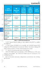
Страница 366: ...Rd S E Salem Oregon 97302 U S A Tel 503 581 8101 or 800 525 6726 Fax 503 364 2138 Garmin Europe Ltd Liberty House Bulls Copse Road Hounsdown Business Park Southampton SO40 9RB U K Tel 44 0 870 850 1243 Fax 44 0 238 052 4004 Garmin Singapore Pte Ltd 46 East Coast Road 05 06 Eastgate Singapore 428766 Tel 65 63480378 Fax 65 63480278 www garmin com Part Number 190 01150 02 Rev J ...

Отзывы: