background image


Oregon Series Owner’s Manual

Basic Navigation

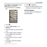
To find a POI by spelling the name:

1.  On the Main Menu, touch 

Where To?


All POI

.

2.  Touch  .
3.  Touch characters to spell at least 

a portion of the name of your 

destination.

4.  Touch  .
5.  Touch the item to which you want to 

navigate.

6.  Touch 

Go

. A colored line indicates 

your course.

7.  Touch   > 

Compass

.

8.  Use the compass to navigate to your 

destination as indicated on 

page 10

.

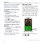
To navigate to a point on the map:

1.  On the Main Menu, touch 

Map

.

2.  Touch the point on the map.

Information 

button

3.  Touch the information button at the 

top of the screen.

4.  Touch 

Go

 >   > 

Compass

.

5.  Use the compass to navigate to your 

destination as indicated on 

page 10

.

Содержание Colorado 400t

Страница 1: ...Oregon series owner s manual...

Страница 2: ...Information in this document is subject to change without notice Garmin reserves the right to change or improve its products and to make changes in the content without obligation to notify any person...

Страница 3: ...Conventions In this manual when you are instructed to touch something use your finger to touch that item on the screen Small arrows used in the text indicate that you should touch a series of items in...

Страница 4: ...ted in the battery compartment Remove batteries as indicated on page 2 Optional Accessories For a list of available accessories and maps for use with the Oregon refer to the Garmin Web Site at http bu...

Страница 5: ...a Destination 5 Applications 8 Satellite Page 8 Map Page 8 Compass Page 10 Trip Computer 12 3D View 13 Geocaches 13 Elevation Plot 14 Wherigo 15 Share Wirelessly 15 Image Viewer 16 Waypoint Manager 16...

Страница 6: ...de 32 Connecting Your Oregon to a Computer 32 Installing a microSD Card 32 Transferring Tracks Routes or Waypoints 33 Loading and Deleting Files 34 Optimizing Battery Life 35 Restoring Factory Default...

Страница 7: ...Oregon Series Owner s Manual Getting Started Getting Started Power key Mini B USB jack under weather cap Latch Mounting spine Battery cover Touchscreen...

Страница 8: ...sert the batteries observing polarity 3 Replace the battery cover and push the latch down To select the battery type 1 On the Main Menu touch Setup System Battery Type 2 Touch Alkaline Lithium or NiMH...

Страница 9: ...vigate a route you must acquire GPS signals To acquire GPS satellite signals 1 Go outdoors to an open area away from tall buildings and trees 2 Turn the Oregon on Acquiring satellite signals can take...

Страница 10: ...are with other users Before using your Oregon the first time you may want to mark your current location as a waypoint walk a short distance away and then navigate back to the waypoint you just created...

Страница 11: ...h Compass 6 Use the compass to navigate to your destination as indicated on page 10 Where To may include the following categories Recent Finds items you have recently found Waypoints a list of waypoin...

Страница 12: ...tem to which you want to navigate 6 Touch Go A colored line indicates your course 7 Touch Compass 8 Use the compass to navigate to your destination as indicated on page 10 To navigate to a point on th...

Страница 13: ...4 Touch the location you want to search near 5 Touch a category Items are listed in order of distance from the location you selected 6 Touch the item to which you want to navigate 7 Touch Go A colore...

Страница 14: ...e bottom of the Main Menu Satellite Page Satellite locations Elevation Satellite strength The green bars indicate GPS satellite strength White bars indicate that the Oregon is still collecting data Ma...

Страница 15: ...button To show or hide data fields 1 On the Main Menu touch Setup Map Data Fields Show Data Fields 2 Touch Never When Navigating or Always To change the Map page data fields 1 On the Map page touch o...

Страница 16: ...compass off see page 28 To open the Compass page touch Compass Hold the compass level when navigating to ensure maximum accuracy Bearing and Course Pointers The Oregon can use either a bearing or cou...

Страница 17: ...e course line to destination to compensate for deviation and to get back on course This is most useful if you are navigating on water or where there are no major obstacles in your path It also helps y...

Страница 18: ...ch Start and follow the on screen directions Too Fast or Too Slow may appear notifying you to adjust your turning speed If Calibration Failed appears touch OK and repeat the process Trip Computer The...

Страница 19: ...Main Menu touch 3D View 2 Touch to increase the angle of elevation and touch to decrease the angle of elevation Touch to pan the 3D map forward and touch to pan the 3D map backward Touch to rotate the...

Страница 20: ...on page 10 To navigate to a geocache using Where To 1 On the Main Menu touch Where To Geocaches 2 Touch the geocache to which you want to navigate For more information on geocaching visit www geocach...

Страница 21: ...o a physical location where you will interact with virtual objects and characters For complete information on Wherigo and additional cartridges software game files visit www wherigo com Share Wireless...

Страница 22: ...he Garmin drive page 34 OR Insert a microSD card with jpg images in the microSD card tray page 33 2 On the Main Menu touch Image Viewer 3 Touch or to scroll through the pictures Waypoint Manager You c...

Страница 23: ...l use to automotive use On the Main Menu touch Profile Change Your current profile is indicated on the screen Touch the profile you want to use When you are in a profile and change settings such as da...

Страница 24: ...n additional point on the route The additional point is inserted before the point you are editing Remove removes the point from the route To delete a route 1 On the Main Menu touch Route Planner 2 Tou...

Страница 25: ...ent track on the map View Elevation Profile shows the elevation plot page 14 for your current track Save Track saves your current route Save Part allows you to select a portion of your current track t...

Страница 26: ...On the Main Menu touch Sun and Moon Touch or to view sun and moon information for a different date Alarm Clock You can set the Oregon 300 400t 400c and 400i to turn on at a specified time To set the...

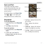
Страница 27: ...se the Stopwatch 1 On the Main Menu touch Stopwatch Start 2 Touch Stop to stop the timer To use the lap timer 1 On the Main Menu touch Stopwatch Start 2 To mark a lap touch Lap The Oregon will mark a...

Страница 28: ...ype select the type of battery you are using Tones turn audible tones On or Off Interface set the Oregon serial interface Garmin Spanner allows you to use the Oregon USB port with most NMEA 0183 compl...

Страница 29: ...etup On the Main Menu touch Setup Map Orientation select how the map is shown on the page North Up always shows north at the top of the page Track Up shows your current direction of travel toward the...

Страница 30: ...ce enter the specific time or distance interval Touch Auto to record the tracks at a variable rate to create an optimum representation of your tracks Interval select a track log recording rate Recordi...

Страница 31: ...touch Setup Profiles 2 Touch a profile Delete It is not possible to delete your current profile To add a new profile 1 On the Main Menu touch Setup Profiles Create New Profile This newly created prof...

Страница 32: ...point on the active route page Distance routes you to the next point on the route when you are within a specified distance of your current point Avoidance Setup touch the road type you want to avoid M...

Страница 33: ...ect Yes to use Daylight Saving Time No to ignore it or Automatic to automatically turn on and off Daylight Saving Time Units Setup On the Main Menu touch Setup Units Distance Speed select distance and...

Страница 34: ...reference Magnetic automatically sets the magnetic declination for your location Grid sets grid north as the heading reference 0 User allows you to set the magnetic variation value Go To Line select...

Страница 35: ...data only when the Oregon is turned on This can be useful when you are watching for pressure fronts Plot Type select the elevation plot type Elevation Time records elevation changes over a period of...

Страница 36: ...t time your Oregon automatically recognizes the wireless sensor whenever they are turned on and within range of each other To pair the Oregon with a wireless sensor 1 Place the Oregon within 10 feet 3...

Страница 37: ...mperatures Power Source Two AA batteries alkaline NiMH or lithium Battery Life Up to 16 hours Accuracy GPS 33 ft 10 m 95 typical Subject to accuracy degradation to 100 m 2DRMS under the U S DoD impose...

Страница 38: ...GPS receiver is turned off Any satellite signal strength bars shown are only simulations and do not represent the strength of actual satellite signals To turn Demo Mode on touch Setup System GPS Demo...

Страница 39: ...ard lift the metal cover and remove the card from the microSD card tray 5 Replace the batteries and the battery cover In addition to map and data storage the microSD card can be used to store files su...

Страница 40: ...98 Me or NT It is also not compatible with Mac OS 10 3 or earlier To load a file onto the Oregon or microSD card 1 Remove the battery cover and insert a microSD card page 33 2 Connect the USB cable to...

Страница 41: ...will significantly decrease battery life Select a shorter backlight timeout page 22 Turn tones off if not needed page 22 Turn electronic compass off if not needed page 28 If you plan on using the Ore...

Страница 42: ...ating the Touchscreen The Oregon screen does not normally require calibration However if the buttons do not seem to be responding properly use the following process To calibrate the touchscreen 1 Whil...

Страница 43: ...de secret of Garmin You agree not to decompile disassemble modify reverse assemble reverse engineer or reduce to human readable form the Software or any part thereof or create any derivative works bas...

Страница 44: ...sor 30 calculate routes for 26 calculator 20 calendar 20 calibration altimeter 29 compass 11 carabiner 36 Communicator Garmin 13 compass 10 calibration 11 north reference 28 contact Garmin ii course 2...

Страница 45: ...in out 22 north reference compass 28 north up 23 numeric degrees 28 O off road 25 off road transitions 26 on road for distance 26 on road for time 25 optional accessories ii orientation map 23 P pann...

Страница 46: ...up 22 T text out 22 text size maps 24 timeout backlight 22 time setup 27 time zone 27 tones 22 tracks 19 recording 24 recording method 24 recording rate 24 setup 24 track up 23 trip computer 12 trip d...

Страница 47: ......

Страница 48: ...www garmin com 2008 Garmin Ltd or its subsidiaries Garmin International Inc 1200 East 151st Street Olathe Kansas 66062 USA Garmin Europe Ltd Liberty House Hounsdown Business Park Southampton Hampshir...

Отзывы: