- 54 -
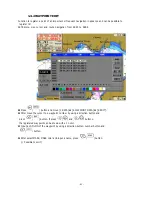
The red line is shown from a current position to a first route position and
the rest positions registered into a route navigation is shown with a bright-grey line.
The Lat/Lon, approach speed, direction, distance and time of the navigating route
point are shown in a bottom-left of the plotter screen. ( Refer to 'Chapter 3. 5. Plotter Screen'
☞
.)
In order to 'How to clear Route Navigation', move
[2.SET]
¨
[1.NAVIGATION SET]
¨
[4.EXIT WPT/RTE/ANCHOR] and
press
(
) button or press
(
) button
( Refer to '2.1.4 EXIT WPT/RTE
☞
/ANCHOR')
Содержание FEG-881
Страница 1: ...FEG 881OPERATION MANUAL 8 INCH COLOR GPS PLOTTER FISH FINDER...
Страница 5: ...1 This chapter provides an overview of the GLOBAL POSITIONING SYSTEM GPS 1 GPS PLOTTER...
Страница 17: ...13 GPS Plotter Display 28 2 3 1 4 7 21 22 5 10 12 13 14 15 17 18 16 27 11 8 19 20 23 24 25 26 6 9...
Страница 19: ...15 C MAP Plotter Display 2 3 1 4 7 21 22 5 10 12 13 14 15 17 18 16 27 11 8 19 20 23 24 25 26 6 9...
Страница 21: ...17 Day Night Mode in Plotter Display Press Open the menu such as Transparency Day Night mode...
Страница 23: ...19 Fish finder Combo Display Fish finder Display...
Страница 96: ...92 4 7 A SCOPE SET A scope on or off n Press and then go to 4 FISH 7 A SCOPE SET o Select ON OFF and then press...
Страница 105: ...101 APPENDIX 2 CONNECTING PINS...
Страница 106: ...102 DIMENSIONS need more than 100mm for service space in main body rear unit mm...
Страница 107: ...103 INSTALLING TO THE MAIN BODY...
Страница 111: ...107...
Страница 112: ...108 Marine Products Division 601 Fuseminami Bld 3 1 7 Ajiro Higashi Osaka Osaka Japan 577 0841 http www nakanoeng com...


