1. OPERATIONAL OVERVIEW
1-6
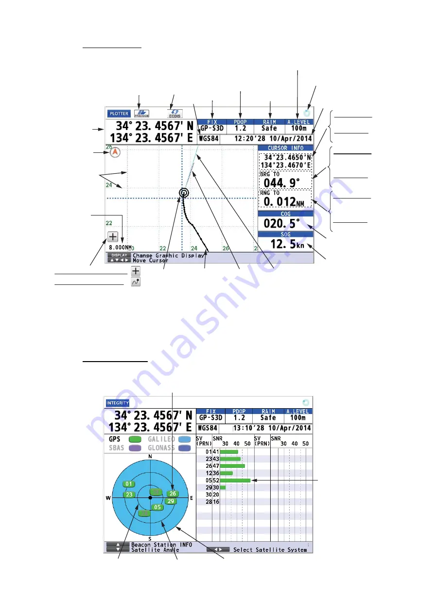
Plotter Display
Note:
The color of the ship’s position data depends on positioning status.
Integrity Display
Black: GPS position fix
Red: No GPS position fix
Cursor mode:
Bearing from
ship to cursor,
Chart mode:
Bearing
Cursor mode:
Range from
ship to cursor,
Chart mode:
Range
Course over
ground
Speed over
ground
Ship’s mark
Course bar
Cursor mode:
Cursor position,
Chart mode:
No indication
Ship’s
position*
Cursor on (Cursor mode):
Cursor off (Chart mode):
North
mark
Spinner rotates when
the equipment is
functioning normally.
RAIM reliability
Datum
Status
indication
HDOP: 2D
PDOP: 3D
Time and date of
Position FIX
Distance for RAIM reliability
This icon appears when the number
of satellites used for positioning is
more than four and the high preci-
sion speed computing is available.
*: Shows the ship’s position adjusted with the setting position offset based
on the selected datum (refer to paragraph 9.3.5).
Grid
This icon appears
during the
synchronization
with ECDIS.
Ship’s track
Heading line
Range
scale
Elevation 60°
Elevation 30°
Elevation 0°
Receiver
signal level
(Bars show
signal level.)
Satellites used for positioning (Satellite numbers used for positioning
are displayed in white, or black if not used for positioning.)
Содержание GP-170
Страница 1: ...GPS NAVIGATOR GP 170 OPERATOR S MANUAL www furuno com Model ...
Страница 107: ...AP 9 APPENDIX 3 TIME DIFFERENCES ...
Страница 114: ...FURUNO GP 170 SP 4 E4482S01C This page is intentionally left blank ...
Страница 117: ......


