background image

NAVIGATION 


Tap on the Crossroad field to select a point where another road joins the entered road. 

The screen will change to show a list of all joining roads, use the 

 or 

 keys to move 

through the list until you see the correct road. Select the desired road and tap 

 or 

double tap to confirm. You can also enter the name of the road by tapping on the white 
box at the top. 
 
When entering an address you have the following options; 

Tap 

. Once you have fully entered the destination you want to navigate to and are 

happy, you will now be taken to the Route Plan screen (see page 35). 

Tap 

 to view the location on the map and once in the map view you can browse 

the map (see page 20), to exit from the map view back to the previous screen tap 

You also have the option of selecting a point from this map to navigate to. This can be 
used to exactly pin point your location, or allow you to quickly select a point on the map to 
navigate to without having to scroll the map to the area you wish to select around.  Place 

the cursor on the point you would like to navigate to and tap 

. You will be taken 

directly to the Route Plan screen and your selected point will be entered as the 
destination. 

Tap 

 to cancel entering an address and to return to the Search Menu screen. 

 
6.2 Searching for a POI (Point of Interest) 

The POI search allows you to quickly find 
points of interest like petrol stations and 
places to eat in a database of millions of POI. 
These places can be either close by or at a 
distant location. 
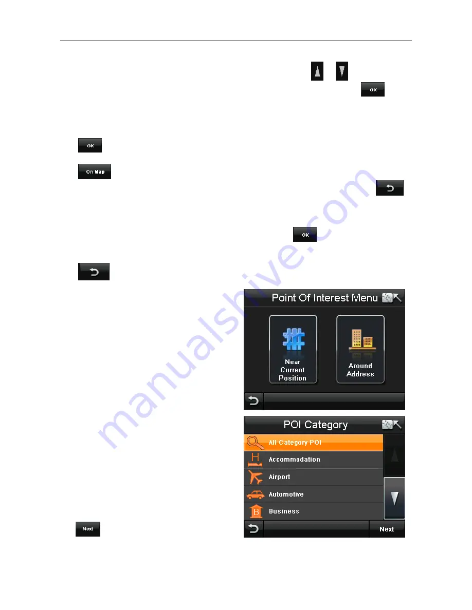
Tap POI to begin searching through the POI 
database. 
When tapped the screen will change to the 
POI Menu, with two options available for 
searching for a POI: Near Current Position 
and Around Address. 


6.2.1 Near Current Position 

Use this option to search for a POI from a 
particular category or for all categories 
around your current location as shown on the 
map (this will either be your current GPS 
position or the position where you last had a 
GPS lock). 
From the POI category screen select the 
category for which you want to search in and 

tap 

. The screen will change to show 

you all the POI for that category which are near your position starting with the closest. 


Содержание F350 - EDITION 5

Страница 1: ...User Guide F350 5th edition www binatonegps com Binatone Navigation software ...

Страница 2: ...lace in case you later need to transport the unit Keep your sales till receipt which is your guarantee Before you can use the unit you ll need to fully charge the battery as described on page 6 please also read the notes on the page 2 WARNING Your GPS device operates under open sky conditions in order to receive a satellite signal Please ensure that you are not using the device indoors or in areas...

Страница 3: ...mounting the PND in your car make sure that it does not obscure your view or impede the operation of any driving controls Prohibited Areas Do not operate your PND in hospitals or near any electrical medical equipment Do not operate your PND in aircraft Do not operate while on a petrol station forecourt Battery Your PND uses a Li polymer battery Do not use it in humid wet or corrosive environments ...

Страница 4: ...rt Guide 06 Position of the Controls 06 Charging the Battery 07 SD Memory Card 07 Car Adaptor 07 Turning the Sat Nav Unit On Off 08 Turning the Sat Nav Unit Off Sleep Mode 08 System Reset 08 Windscreen Holder Installation 09 Getting Started 10 Starting Up 10 Settings 11 Multi Media 12 Picture Viewer 12 Document Viewer 13 GPS Receiver 14 Additional maps and upgrades 14 ...

Страница 5: ...g an Entry from the Address Book 24 6 4 Selecting a Recent Destination 24 6 5 Selecting a Point on the Map 24 6 6 Entering a set of Co ordinates 25 6 7 To Navigate Directly Home 26 7 Map Options 26 7 1 North Up Heading Up 26 7 2 3D 2D 27 7 3 Motorway Sign Post 27 7 4 Voice Guidance 28 7 5 Auto Zoom 28 7 6 Simulation Speed 28 8 Settings 28 8 1 Language 29 8 2 Safety Alert 29 8 3 Trace Record 29 8 4...

Страница 6: ...6 10 2 Detour 36 10 3 Cancel Route 37 10 4 Go to 37 10 5 Route Information 37 10 6 Map Options 37 10 7 Settings 37 Frequently asked questions 38 The map contains an error POI s are missing 38 I am experiencing problems getting a GPS fix 38 Where can I get technical support 38 Where can I get additional maps and guides 38 Technical Specifications 39 EC Declaration of Conformity 40 ...

Страница 7: ...Indicator Displays the battery charging status Red charging Green fully charged 3 On Off button Turn On the unit when it is Off or in Sleep mode Turn the unit to Off or put into Sleep mode during operation 4 Reset System reset switch 5 Speaker For voice guidance instructions 6 Memory Card Slot Compatible with MicroSD cards Do not remove a memory card while it is in use 7 Power Connection USB Port ...

Страница 8: ...tery level If you have a MicroSD memory Card you may install it refer to the picture below Switch the unit off first before installing or removing the MicroSD card When installing it can only be fitted one way the contacts should be away from you and the cut off corner at the top as shown above Slide the card in and push it in so that it clicks into place Once the card is installed it does not nee...

Страница 9: ... to turn the unit Off There is a 10 second timer which starts to count down if there is no selection made within 10 seconds the unit will turn off automatically Note If the unit is not to be used for a long period of time it is advised that you switch the unit Off System Reset Under extreme circumstances it may be necessary to reboot the system Reset the system if the following situation occurs Lo...

Страница 10: ...ug on the end of the ball mount at the end of the car mount and then push down firmly until it clicks in to place The bracket can only be fitted one way C Fitting the Unit Slide the unit into the bottom of the bracket and carefully push the unit up and back until it clicks into place at the top To remove the unit from the car mount Press and lift the tab at the top of the bracket then pull the uni...

Страница 11: ...MAIN MENU Starting Up Press the On Off button on the top until the following screens are displayed When you press MENU the following screens will be displayed ...

Страница 12: ...e un mute the speaker is shown when un muted is shown when muted Clicking or can release the mute status Press to confirm and exit Backlight Press Backlight to change the brightness of the screen You can make it darker or brighter by clicking or This can also be done via the navigation software later Press to confirm and exit Date Time This device can auto set the current date and time by receivin...

Страница 13: ...tion This function calibrates the unit to respond to your screen taps You will need to use this function only if the unit begins to respond inconsistently to your screen taps After selecting follow the on screen directions Once the calibration has been completed press anywhere on the screen to return to the previous menu Multi Media NOTE if you press on the MULTI MEDIA icon the following screen is...

Страница 14: ...to view the next picture in the list 6 Full screen Press to enlarge the picture so that it fills the whole screen You can now use the stylus to scroll around the picture To return back to the above screen double tap the screen You can also double tap to switch to full screen mode 7 Rotate Press to rotate the image 90 degree right 8 Document name This shows the file name of the current document Doc...

Страница 15: ...g also the strength of these signals This page gives your current position in degrees longitude and latitude your current speed and the status of your position i e Fixed 3D or Fixed Invalid etc The compass circle shows the satellites that the unit is receiving and the bar chart shows the signal strength for these satellites NOTE At least four GPS signals are required for the PND to function There ...

Страница 16: ...gh the main features of the system 1 1 GPS connection Your navigation device uses GPS technology for navigation The device receives signals from a number of GPS satellites in order to determine your current position Place your navigation device in a location with an unobstructed view to the sky to set up your first satellite connection In the car this will usually mean mounting the unit on the low...

Страница 17: ...ing needs For more information on free navigation mode see page 20 In order to enter destinations and access the many settings of the navigational software tap Menu This will then take you to the Free Navi Menu screen You can choose from the 3 following options Go to Opens the Search Menu screen From here you can select a point to navigate to Map Options Allows you change the way the map looks and...

Страница 18: ... 3 Speed Shows your current speed 4 Menu button Tap to access the Free Navi Menu screen Only when in Free Navigation 5 Time Shows the current time Note this is set when you have a valid GPS lock 6 Map scale Show a scale bar which changes as the map zoom level is altered 7 Volume Tap to access the volume control menu 8 Zoom in Tap to zoom in on the map 9 GPS reception Shows the current status of th...

Страница 19: ...he voice instruction 13 Current road Shows the name of the road you are currently on 14 Menu button Tap to access the navigation options Only when in Route Navigation 15 Distance Shows the remaining distance to your destination 16 Arrival time Shows the estimated time you will arrive at your destination 17 POI icon Show the position of a point of interest 18 Next road Shows the name of the road yo...

Страница 20: ...to your current or last known GPS position 5 Navigation There are two modes of navigation Free navigation and Route Navigation 5 1 Free navigation In free navigation the unit does not have a planned route for you to follow so simply plots your GPS position on the map and then follows your movement as you drive The unit shows you the current time and date as well as your current position in latitud...

Страница 21: ...ng for and tap Tap to accept or double tap the country name Now the screen will change to show either a keyboard if no previous city has been entered which allows you to enter the name of the city or postcode you are looking for or you will be shown a list of previously entered cities as covered above If the country is correct and the required city does not appear on the previously used list or yo...

Страница 22: ...on even further UK ROI Version Tap on the Road field to enter a road name you will be taken to the keyboard screen again As for when entering a city name the unit will begin matching the name and narrowing down the possible matches Western Europe WEU Version Tap on the Road field to enter a road name you will be taken to the keyboard screen again But this time the name will not be matched as you g...

Страница 23: ...h to select around Place the cursor on the point you would like to navigate to and tap You will be taken directly to the Route Plan screen and your selected point will be entered as the destination Tap to cancel entering an address and to return to the Search Menu screen 6 2 Searching for a POI Point of Interest The POI search allows you to quickly find points of interest like petrol stations and ...

Страница 24: ...creen tap You also have the option of selecting a point from this map to navigate to this can be used to exactly pin point your location Place the cursor on the point you would like to navigate to and tap You will be taken directly to the Route Plan screen and you selected point will be entered as the destination Note When you carry out a search for a particular name of a POI The unit will search ...

Страница 25: ...n browse the map see page 20 to exit from the map view back to the previous screen tap Tap to delete the currently selected address book entry Warning you will not be asked to confirm the deletion so make sure that you wish to carry out this operation before tapping Note In order to use the Address Book option you will first need to store entries to the address book This can be done via the Addres...

Страница 26: ...reen will then change to show the Route Plan screen see page 35 6 6 Entering a set of Co ordinates This option allows you to enter the longitude and latitude co ordinates of the location you are looking for Tap Coordinates the screen will change to the co ordinates entry screen You can enter the co ordinates in two different ways Degrees minutes seconds or as a Decimal the unit automatically defau...

Страница 27: ...looks and behaves during navigation When tapped the screen will change to the Map Options screen from where you can easily select several options 7 1 North Up Heading Up Changing this option changes the way the map is orientated when you are navigating North Up Means that the map will be fixed so that North is upwards The position icon will be shown in the centre of the screen and will rotate to s...

Страница 28: ... the unit will show you information about the approaching junctions along the planned route You will be shown the distance to the junctions as well as what the junction sign post will have written on it The unit will also show the action you need to take at each junction The icon means continue along the current road The icon means to take the junction and exit the current road In addition to this...

Страница 29: ... activated the box will be shown with a tick 7 6 Simulation Speed This option allows you to change the speed at which a simulation of a route is carried out You can set the speed between 50 300 Mph Kph For more information on carrying out a simulation of a route see page 36 Tap to confirm the change 8 Settings These are the main settings of the unit and allow you to set the unit up to suit your in...

Страница 30: ... many roads When activated the unit will show you the speed limit for the road you are on with a fixed speed limit icon if you exceed the speed limit including any tolerance you have set for the road you are on the speed limit icon will flash and the unit will beep When the option is shown with an orange indicator it is activated When active you can then change the speeding tolerance using the and...

Страница 31: ... the button to view the trace record on the map When active the button will then change to show The trace record will be shown as a slightly opaque orange line with green arrows indicating the direction of travel Note it is only possible to show one trace at a time A trace record which is been shown will be shown with a blue highlight on the list If you select a second Trace and tap this will canc...

Страница 32: ...enter a telephone number for your address book entry Remark You can then enter a short remark for the location Coordinate This is fixed and shows the co ordinates for the entered location Icon Tap the icon you are then able to select from 10 different icons which are used to indicate this address book location on the map Highlight the icon you wish to use and tap Once you have entered the informat...

Страница 33: ...tomatically switch to Night mode You can set a start time of between 1 00 till 12 00 AM and an end time of between 1 00 till 12 00PM Use the and buttons to select the start and end time This way you can customise the Day Night Mode for any time of year Once set tap to confirm the selection and return to the settings screen Tap to return to the settings screen without saving 8 6 Set Home Address Al...

Страница 34: ...ption to change between Miles and Kilometres The currently selected option will be shown on the screen 8 9 About Tapping this option will show you information relating to the version of navigation software you are running 8 10 Time Zone Allows you to change the time zone so that the time is always correct for the country you are in There are two options to choose from manually and automatic The se...

Страница 35: ... you have entered your destination and confirmed it is correct you will be taken to the Route Plan screen from here you can begin navigating carry out a simulation of the route or add additional waypoints to the journey Tap to return to the Free Navigation Menu screen Select a destination so that it is highlighted orange and tap to view the location on the map 9 1 Navigating To begin navigating to...

Страница 36: ...ighted orange then use the keys to move it up or down in the list Once you have entered all your waypoints and they are in the correct order tap the unit will calculate the route and change to the route navigation screen 9 3 Simulate Before you navigate a route for real you can simulate the route on the unit To simulate the route tap you will be asked if you would like to change your starting poin...

Страница 37: ...alculated from your current position Any changes will be taken in to consideration when calculating the route 10 2 Detour This option allows you to navigate around any traffic jams or blocked roads which are along your planned journey When tapped the screen will change to show the available distance options You will need to estimate the distance to the blocked road traffic jam then choose the opti...

Страница 38: ... explanation of the route which includes the next street name distance between turns and the turn type For example Turn left onto Saxon Gate then drive for 650 yards Use the or keys to scroll through the list of directions If you have added waypoints then the route directions will be split between the different destination waypoints points Each route is viewed separately and is indicated by the 2 ...

Страница 39: ...Ol s are missing If you detect an error in the map data e g a street is missing completely we would like to inform our map data provider Please let us know via our help line 0845 345 9677 I am experiencing problems getting a GPS fix If you have problems getting a satellite fix with GPS you can see how many satellites are being received by going to the main menu and selecting GPS receiver please ma...

Страница 40: ...t in GPS high sensitivity receiver 64 channels Memory 64MB SDRAM Built in Display 3 5 colour TFT touch screen Weight 0 115 kg Input Method Touch Expansion Slot MicroSD card Speaker Built in 1 0W loud speaker Headphone 2 5mm Mini jack USB USB Client for Active Sync I O Battery Re chargeable Lithium Polymer battery Dimension 96mmx74 5mmx11 6mm ...

Страница 41: ...e of equipment GPS Model Name F350 series Country of Origin China Brand Binatone complies with the essential protection requirements of Article 3 1 b of R TTE Directive 1999 5 EC and the following standards Radio Spectrum ETS 300487 A1 1997 EMC EN 301489 19 V1 2 1 2002 11 EN 301489 1 2008 V1 8 1 Electrical Safety EN 60950 1 2001 A11 2004 The product is labelled with the European Approval Marking C...

Отзывы: