background image

AvMap - 3

6.6 Simulating mode

Once  you  plan  your  route,  you  can  always  start  a 
simulation  of    navigation  that  will  display  the  moving 
vehicle  along  the  itinerary  with  the  average  speed  
assigned  to  each  road  by Tele Atlas,  or  you  can  see  it 
speeded  up  x2,x4,x8  times.  During  the  simulation  you 
can consult the itinerary with the list of roads and the 

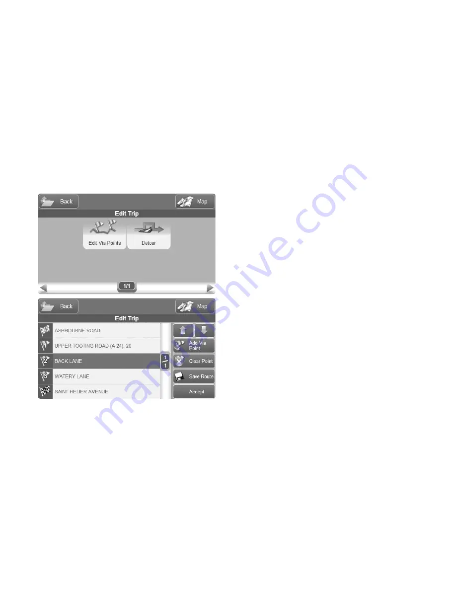
list of manoeuvres. (Par.7). To start a simulation:

• Plan  a  route  from  point  A  to  B  as  explained  in  the 

previous paragraphs. 

• From  the  Start  Navigation  page  (4.6),  press 

Simulation. 

• The simulation menu will open. press On, then choose 

the speed and then press Accept. The map will display 
the simulation of the navigation.

Содержание Geosat 6

Страница 1: ...User Manual ...

Страница 2: ...Dear Costumer Congratulation for choosing an AvMap Satellite Navigator AvMap GPS systems are made in Italy since 1994 SATELLITE NAVIGATION Your journey Our technology ...

Страница 3: ...ination 21 4 1 Search Options 21 4 2 Inserting an address as destination 22 4 3 Choosing the destination among the POIs 24 4 4 Choosing the destination among your Favourite POIs 26 4 5 Choosing the destination among the Contacts 27 4 6 The Start Navigation page 28 5 The map during the navigation 29 5 1 Changing the navigation data 30 5 2 2D and 3D view 31 5 3 Night vision 32 5 4 MyPosition 33 6 Pl...

Страница 4: ...fying a contact 54 10 4 Setting Home address 56 11 Managing saved routes 58 11 1 Saving the route 58 12 Unit status 60 12 1 Unit status Menu 60 12 2 GPS page 60 13 Customizing the settings 62 13 1 The Settings Menu 62 13 2 User Preferences 63 13 3 Interface 64 14 Updates 66 14 1 Checking the Software version 66 14 2 Map update 66 15 Problem solving 67 15 1 RESET 67 Warranty and Support 68 Warranty...

Страница 5: ...r use of the device in a way that may violate the Highway Code The Tele Atlas cartographic data loaded in the navigator may present some discrepancies from the reality This is due to the continuous changes in the street network Some areas have a better coverage than others I I Important notes Important Do not place the navigator in positions that may obstruct the driver s view Do not place the nav...

Страница 6: ...e tools bar or maps introduced after this date will not be present in this manual I II Battery disposal This product is equipped with a built in Li Ion battery Do not use the product in damp or corrosive environments In order to lengthen the life of the battery do not recharge it at temperatures higher than 60 C THE LI ION BATTERY PROVIDED WITH THE PRODUCT MUST BE RECYCLED OR DISPOSED IN THE CORRE...

Страница 7: ...ng of your Geosat If you suspect that the navigator has been over heated because of sunlight exposure let the temperature of the car cool down and wait for the device temperature to go down to normal values before switching it on The Secure Digital memory card should not be formatted nor the content modified Only AvMap branded Secure Digital memory cards are compatible with Geosat Avoid knocking a...

Страница 8: ...Serial port USB master slave Audio output Power supply Power key Microphone Speakers Back II I Hardware features The Geosat 6 is equipped with a 4 8 touch screen a microphone 2 speakers audio output The illustrations show the hardware features On Off Switch Reset ...

Страница 9: ...ette lighter 3 Place the Geosat 6 on the magnetic car mount coupling with a simple gesture 4 Press the power key to power on the navigator 5 The smart magnetic rotating mount makes it possible to rotate the navigator from landscape to portrait mode to choose your point of view The mount has been designed so that the driver can easily rotate the navigator always keeping the eyes on the road the sof...

Страница 10: ...ger in case of accident or sharp braking then place the Geosat 6 on the magnetic mount Move the On Off switch towards the On position and then press the power key to power on the navigator The On Off swith removes the power supply while the power key puts the navigator in stand by 1 2 Accessing to Navigation When powered on Geosat 6 will display the main menu From the main menu you can choose amon...

Страница 11: ...me important warnings are displayed If the warnings are not in the language required it is possible to set immediately the text language by touching the Language setting button Select the desired language for the text and then touch the upper right arrow button to select the voice language for vocal instructions Touch the Accept button to accept the warning and display the Navigation Menu ...

Страница 12: ...ssible 2 1 Fixed buttons Main Menu it opens the Main Menu to choose the function par 1 1 Settings it opens the Settings Menu par 13 Portrait Landscape it allows changing the view mode Attention this button is active only when the Geosat 6 is not attached to the car mount When on the mount it is enough to rotate the navigator and the software will switch automatically from Landscape to Portrait mod...

Страница 13: ...r current GPS position to the address saved as Home to set the Home address par 10 4 Delete route it deletes the current route POI management it opens the Poi Management Menu where you can choose which ones should be displayed on the on map and which are your favourite categories par 9 Contacts management it opens the Contacts Management menu where you can add contacts and organize them in folders...

Страница 14: ... receiver par 12 Interface it opens the menu to set the protocol of communication with external devices page 13 3 Tracks it opens the tracks menu to start recording the track of your movements on the map par 3 2 Trip Computer it opens the trip computer with graphs of speed and other useful information par 8 Where am I It displays details on your position with address and geographical coordinates 5...

Страница 15: ...AvMap 15 2 3 Portrait view When in portrait mode the menu is displayed as follows ...

Страница 16: ...lative explanation A window will open with the instructions on how and why to use the selected button Close the window by pressing Close To get another explanation press again the Help button and repeat the operation 2 5 FAQ s The F A Q section gives you detailed instructions on how to use the most common navigation functions To open the FAQ section press the FAQ button in the navigation menu You ...

Страница 17: ...AvMap 17 Start a Simulation Plan next stop The FAQ can be updated with free software updates ...

Страница 18: ... map To open the map touch the Map button in the Navigation Menu When there is no active navigation the map appears as follows Status icons GPS signal and Battery Scale and Compass Touch to open the Navigation Menu Zoom Horizontal view ...

Страница 19: ... in the desired direction Touch the Zoom buttons to zoom in or out The info bar the blue bar at the bottom of the screen shows the exact address corresponding to the cursor position To get more info on the selected point ouch the info bar and the full info page will open Read Par 5 for the description of the map during the navigation Vertical view ...

Страница 20: ... navigating off road The track is shown on the map with a red line The track can be saved and it be reloaded in any moment To open the Tracks menu Open the Navigation Menu Touch the Tracks button From the Tracks menu you can start or stop the registration of a track and choose its colour The registration will go on till you will manually stop it ...

Страница 21: ...dix B 4 1 Search Options The Where to Go menu offers several options to search for your destination Address to insert a complete address POI to search your destination among the points of interest Address Book to search your destination among the contacts saved in the address book Drive me home to set the home address as destination Lat Lon to inset the destination with the geographical ...

Страница 22: ... an address as destination To insert an address as destination touch the Address button then fill the fields Country City Street and House number Touch the Country field to open the virtual keyboard Digit the name of the country on the virtual keyboard touching a letter at a time Once you have inserted the name touch the OK button Repeat the operation for each field Touch the Go button the button ...

Страница 23: ...arch among the recently found destinations touch the Recent button and then choose among the list of results When inserting an address with the virtual keyboard you can choose to activate or not the auto completing function When the auto completing function is active it helps you inserting the correct name and if you touch OK the green button you can see the suggested result i e If you have insert...

Страница 24: ...ed locations on your cartography which enable to quickly research a certain destination under a category There are websites that specialize in the collection management and distribution of POIs for you to load into your device To search for a POI Open the Navigation Menu Press Where to Go Select POI On the new menu select the research option between Near my position Near a City Near my destination...

Страница 25: ...ies for a complete list consult the appendix Select the POI category you are interested to and then select among the subcategory list displayed For example Transportation category Airports subcategory The navigator will automatically search the closest POI to your current position and will display the full list among which you can choose the most convenient one Once you choose a POI select it to o...

Страница 26: ...ry and the subcategory and follow the steps as above If you choose the Near a via point option you will be displayed the via points list along your route choose a Via Point and then proceed with the selection of a category If you select Near destination proceed with the selection of a category and then subcategory to find POI near your final destination 4 4 Choosing the destination among your Favo...

Страница 27: ... new contact see par 10 3 A contact can be set as destination To access the list Open the Navigation Menu Select Where to Go Select Search Contacts The list of the existing folders will be displayed e g Business Friends Relatives etc Select the desired folder to display the list of contacts Select the contact to access the complete information window Press the green arrow to open the Start Navigat...

Страница 28: ... location Suggestions The orange icon on the side of a folder indicates that the approaching alarm has been set on all the contacts containedinthatfolder Tosetthealarms seetheContact Management section par 10 The orange icon associated to a contact indicates that it has been assigned a GPS position a telephone number or both In case you forget where you saved a contact you can always carry out a n...

Страница 29: ...e navigation Next manoeuvre Distance to next manoeuvre Street name where you are about to turn into Name of the street you are travelling along Navigation data touch to choose the data you wish to display The data displayed by default are time to go distance to go and speed Navigation Menu ...

Страница 30: ...ode speed time to destination and distance to destination These fields can be customized Touch a box to change the information displayed in it Select from the side list the information that you want to display Repeat the operation for information Box 2 and 3 Press Accept to close the window and get back to the map You can choose between Altitude Driving time Average speed Maximum speed ...

Страница 31: ... manoeuvre Expected time to destination Countdown Distance to destination 5 2 2D and 3D view To change the visualization mode on the map Press Navigation Menu Scroll the menu until you find the 2D 3 D button Select 2D 3D when you are in 3D you will see the 2D button vice versa when in 2D you will see the 3D ...

Страница 32: ...ant to consult the map by clicking on a certain point or on the zoom in zoom out the view mode will turn into 2D and it will then automatically switch to 3D when the operation is over 5 3 Night vision With Geosat 6 it is possible to set the night vision for a safer drive The night vision changes the colour palette to allow an easier consultation in absence of light To switch to night vision Press ...

Страница 33: ... perceived by the sensor on the back of the Geosat 6 5 4 MyPosition To have a detailed information on your GPS position while navigating or not you can consult the page My Position Press the Navigation MENU button Select My Position The page will display the precise address of the GPS position and the geographical coordinates Latitude Longitude From this page you can also search useful POI close t...

Страница 34: ... and the destination point Enter the address by following the procedure described in paragraph 4 up to the Start Navigation page In the Start Navigation page you can set the entered address as a departing point by pressing Set as Departure A page will open up asking Do you want to set a destination now Press Yes the Where to Go Page will open Repeat the procedure to enter the destination On the St...

Страница 35: ... series of useful options to modify and optimize the route according to your needs The options are Clear route Modify route to modify the via points sequence and set detours Plan next stop to set the next via point along your route Route overview to visualize all the information on the route such as the expected time of arrival the time to destination and distance to destination Turn List to visua...

Страница 36: ...will display a departing flag a destination flag and a via point flag To add a second via point simply repeat the operation Once you have added all the via points you can always change its sequence 6 5 Changing the Via Points sequence Open the Navigation Menu Select Route Functions Select Edit Trip Select Edit Via Points You can change here the order of the via points delete them or add new ones T...

Страница 37: ...can see it speeded up x2 x4 x8 times During the simulation you can consult the itinerary with the list of roads and the list of manoeuvres Par 7 To start a simulation Plan a route from point A to B as explained in the previous paragraphs From the Start Navigation page 4 6 press Simulation The simulation menu will open press On then choose the speed and then press Accept The map will display the si...

Страница 38: ...s Simulation To stop the simulation open the same page and press the Off button In the Simulation Settings page you can choose the simulation speed among Real Time Speeded up x 2 Speeded up x 4 Speeded up x 8 To stop the simulation select Off in the Simulation Settings menu ...

Страница 39: ...on simply pressing the arrow that indicates the next manoeuvre in the upper left corner of the map 7 2 Detouring to avoid a street You can choose to detour a route by avoiding a street To open the list of streets along the route open the Navigation Menu select Route Functions and then select Detour You can select one street and choose to avoid it by pressing Detour The Navigator will recalculate t...

Страница 40: ...ping an address then in the Start Navigation page par 4 6 press the Block street button The street will be displayed in red and two red icons will delimit it 7 4 Route overview On the Route Overview window you can find the most relevant information concerning the route for you to consult during your trip or while planning it Point of departure Point of arrival Departure Time Total Distance Remaini...

Страница 41: ...e cover on toll roads Total Km to be cover on unpaved roads Pressing on these icons you access to the Route Options menu where you can decide to avoid for example unpaved roads From the Route Overview page select Show route on map to view the complete route in one screenshot Press Set Departure Time to set the departure time this allows you to get a preview of the estimated time of arrival ...

Страница 42: ... access the route planner Open Navigation Menu Select Route Functions Select Plan next stop You will be able to search the position where you will be within a certain distance or a certain time frame from the point of departure and to search POIs near that position Let s take this as an example shall you want to stop for refuelling within 100 Km from your departure ...

Страница 43: ...int Shall you for instance want to find a restaurant within two hours Select the option When Set the time and select the Restaurants option The software will calculate you position using the average speed allowed in every street according to Tele Atlas official data or the average speed that you Suggestions To better plan your next trip you can do it even without the GPS signal while in the office...

Страница 44: ... 7 6 Choosing Route Options The Route Options menu allows setting the best calculation according to your own needs The menu includes two windows The first includes the Avoid option that allows excluding Toll roads Highways U turns Pedestrian roads Ferry routes Built up areas Unpaved roads High traffic ...

Страница 45: ...ll find the following options Shortest route Fastest Route Off road Suggestions Bear in mind that the shortest route is calculated only according to distance without considering the street type In case you want to avoid secondary roads or unpaved roads select Fastest route option ...

Страница 46: ...representation includes present speed maximum speed reached and average speed Altitude graphic representation includes present altitude maximum altitude reached and average altitude Via Points summary start time of last stop last stop duration last stop position Total counters The trip counters can always be reset Nevertheless the Geosat 6 will always keep in memory its total distance time speed v...

Страница 47: ...AvMap 47 ...

Страница 48: ...s you can add new ones All you need to do is to download the special software available from the AvMap site www avmap it and then consult specialized sites such as e g www poigps com These POIs are called Users POIs 9 2 Displaying or Hiding a POI category By default all the POIs are visualized on the map with their corresponding icon Nevertheless you can always decide to hide some POIs categories ...

Страница 49: ...ite POI categories The Favourite POI list has the purpose of simplifying the research by frequently searched POI categories for instance Gas stations restaurants ATMs etc To enter the favourite POIs list Open the Navigation Menu Select POI Management Select Favourite POIs to view the favourite subcategories list Select an item from the list and you will access the menu that allows to delete it fro...

Страница 50: ...l be added to the favourites list to facilitate your research 9 4 I User POI You can download new POIs such as speed cameras shops restaurants etc You must first register your device on the www avmap it web site under the Support Register section in order to be able to download the Geosat update application Download the POIs from your favourite internet site ex www poigps com paying attention to c...

Страница 51: ... and Password will be requested Save the File on your Pc Once the software has been downloaded on your PC connect the Geosat 6 to the USB port with its wire Run the Geosat 6 Updater application and select the POI tranfer icon This application allows you to select the files to transfer into your navigator A window will show the user POI already loaded in the navigator Select the icon to add a new f...

Страница 52: ...personal POIs Select User POI option from the POI Management Menu The complete list of the user s POIs will be displayed Select a group to access the complete info From here you can Set an approaching alarm to all the POIs belonging to the group View or hide the POI icon from the map Add the group to favourites ...

Страница 53: ...gation Menu Press Contact Management 10 2 Creating or modifying a folder When you access the address book on the left side of the screen you will find the list of the folders and on the right side the buttons for their management To add a new folder press Add folder option The Folder Options menu will appear You can Edit the name of the folder A virtual keyboard will be displayed Type the name you...

Страница 54: ...er s attributes Enter the file by selecting it from the list Then press Modify file to access the Folder Option menu 10 3 Saving or modifying a contact To save a contact enter the related folder by selecting it from the list of folders Then select Add a contact the Add contact menu will open choose here in which way you want to select the address To add an address select address and follow the sam...

Страница 55: ...he contact to another file where it has been saved Add a new telephone number Delete the newly created contact Set the contact as Home Press the Edit name button to change the name the keyboard where to type the name will be displayed Select OK to go back to Contact Options After you have done all the modifications select Accept A new page with be displayed with the option navigate to the contact ...

Страница 56: ...kly recalled with the quick Drive me Home command from the Navigation Menu To set your home address Enter the address by following the procedure on par 4 On the Start Navigation page select Set as Home The Drive me Home function will activate the navigation from the current GPS position to the address set as Home ...

Страница 57: ...dd as contact button to add the address in the contact address book From the Where to Go Menu insert an address in the same way you would do to search for a destination than in the Start Navigation page press the Add as contact button Save your Home address This way it will be very easy to find the way back home thanks to the Drive me Home shortcut button The navigator saves all the new contacts i...

Страница 58: ...Select Save Route A virtual keyboard will appear edit the name of the route and press OK The route is added to the list of saved routes 11 2 Modifying or using a saved route In order to open the list of saved route open the Navigation Menu then select Saved Routes Management menu Select the desired route to open the Saved route options menu In this page you can Rename the route ...

Страница 59: ...e press the chequered flag button to calculate and start the navigation along the saved route If the saved starting point is different from your current GPS position the software will calculate the route from your current position to the saved starting point then heading to the final destination Once you are navigating on the saved route you can always modify it The changes won t be saved unless y...

Страница 60: ... be able to check Battery status GPS signal status TMC signal status on models that have it integrated Bluetooth status on models with Bluetooth 12 2 GPS page On the GPS page the satellites and a series of data such as altitude current position ground speed movement direction hour and date are displayed Press Reset to restart the GPS antenna and Data Display to view the data page ...

Страница 61: ...AvMap 61 ...

Страница 62: ...ed parameters such as language average speed etc Route Preferences to set the route preferences par 7 6 Simulation To simulate a navigation only when a route has been previously set Map settings to set the map visualization Icons on Map to set icons visualization on map Time zone to set the time zone Traffic to set TMC functions TMC receiver needed Information box to set navigation data visualized...

Страница 63: ...vice such as software version and cartographic version Delete recent to delete the recent addresses list 13 2 User Preferences The User Preferences Menu allows to set personalized parameters General settings Measurement unit Start page Navigation Menu or Map Icon Beep Language Text Language Vocal instruction language ...

Страница 64: ...ation such as street names Screen settings Brightness Night day vision Volume to set the speakers volume Battery to set the power saving mode Alarms to delete or shut down the alarms Personal Speed to set your own average speed on every street type This setting allows to have personalised calculations 13 3 Interface To set the communication protocol with external devices through the serial port ac...

Страница 65: ...AvMap 65 Open the Navigation Menu Press Interface Then choose between TMC APRS 4800 for traffic information receiver TMC receiver needed APRS 9600 for APRS communication on APRS ready models ...

Страница 66: ...e is FOC and can be downloaded through the application available on the website For more information visit www avmap it 14 2 Map update For a safer navigation it is important to have updated cartographic data The cartographic update is released about 3 times a year by Tele Atlas and it is not free of charge To verify which cartographic version your navigator has Open Navigation Menu Press Settings...

Страница 67: ...f software failure and impossibility to switch it off you will have to reset the device Insert a metal pointed object on the reset hole that is on lower right side of the device The device will switch off and then you will be able to turn it on again ...

Страница 68: ...e point of sale If the product displays a possible Conformity Defect it must be returned to the Support Centre within two months since the finding otherwise the Purchaser will lose the warranty right When the Purchaser verifies a Conformity Defect he she must send the product to the Support Centre together with the tax document and the warranty The Purchaser s rights under this warranty are forfei...

Страница 69: ...er Each possible controversy deriving and or connected to the previous conditions of the warranty will be transferred to the exclusive and absolute knowledge of the jurisdiction of Massa MS Repair and replacement under warranty When a Conformity Defect has been confirmed the Purchaser must contact the authorised Support Centre for national territory by one of the following methods Web procedure Th...

Страница 70: ...the national competent Supporting Centre for each country on the web site www avmap it For repairs carried out under guarantee or Product replacement the validity of the warranty continues to have effect from the date on the tax document The Product control and the Conformity Defect Check are exclusive competence of the Supporting Centre ...

Страница 71: ... or attempting to derive the structure of the Licensed Products Use duplication except for a single archival copy reproduction disclosure publication distribution or transfer of the Licensed Products other than as specifically allowed The removal or obscuring of any copyright trademark notice or restrictive legend The modification or creation of derivative works of the Licensed Products Use of the...

Страница 72: ...lic disclosure provision under any federal state or local law it is agreed that the Licensed Products are a trade secret and a proprietary commercial product and not subject to disclosure 6b Applicable for US data only Include the following If End User is an agency department or other entity of any State government the United States Government or any other public entity or funded in whole or in pa...

Страница 73: ...if such Derivative Product has a regional or national coverage and at the same time has a content scale and format that are similar to the basic national products of the Norwegian Mapping Authority 9 Applicable for POI s of the USA only If Licensee licenses POI s of the USA to an End User it is required that Licensee includes the following warranty disclaimer THE PREMIUM POI S ARE PROVIDED AS IS W...

Страница 74: ...ern Ireland Norway Norwegian Mapping Authority Public Roads Administration Mapsolutions Switzerland Swisstopo Netherlands Topografische ondergrond Copyright dienst voor het kadaster en de openbare registers Apeldoorn 2004 USA 2006 Tele Atlas North America Inc Geographic Data Technology Inc All rights reserved This material is proprietary and the subject of copyright protection and other intellectu...

Страница 75: ...lway station CLF car loading facility Emergency Emergency medical service Fire station Hospital polyclinic Police station State Police station Attractions Abbey Castle Castle no Visit Church City centre Construction Fortress Military cemetery Monastery Building Monument Public place Scenic panoramic view Tourist attraction View Water mill Windmill Services Bank Car repair ATM Convention centre Ele...

Страница 76: ...rvices Dentist Doctors Pharmacy Veterinarians Natural attractions Beach Land use Mountain pass Mountain peak Nature reserve Rocks Terrain Government City Hall Courthouse Embassy Frontier crossing Government Building Government Office Prison Shopping Car dealer Shop Shopping centre Vehicle equipment provider Sport facilities Golf course Car race track Horse track Ice skating rink Skating rink Sport...

Страница 77: ...AvMap 77 Appendix B Setting the first destination flux diagram 1 2 3 3b 4 5 ...

Страница 78: ...ia Luxembourg Norway Netherlands Poland Portugal Principality of Monaco United Kingdom Czech Republic Russia San Marino Slovakia Slovenia Tele Atlas and Monolit data Spain Sweden Switzerland Turkey and Vatican City North America 2 GB USA Canada Regional Maps 512 MB UK and Ireland UK and Ireland Extended Northern Europe Benelux Benelux Extended Germany DACH Central Europe Eastern Europe Eastern Eur...

Страница 79: ......

Страница 80: ...www geosat6 com ...

Отзывы: