


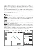


WAYPOINT
Waypoints are an intelligent function, including mission/route-planning
function, geo-fence function and takeoff/point-to-land function. A
waypoint defines a specific location and behavior at a specific point
in time, allowing for intelligent auto-functions during flight.
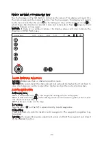
MAP PREPARATION
The map will match with the ST16’s menu-selected language (if English is selected,
the map will be Google Map automatically). The settings icon [ ] may also be
tapped on the right top corner of the screen, and then tap the icon [ ] to switch
the map manually. To download maps, follow the steps below:
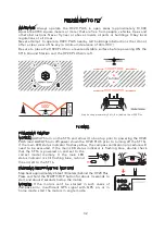
Model: H920 Plus
welcome,Pilot
12:27 AM 12
VOLTS
GPS
SAT
POS
ALT
G-SPD
DIS
N/A
N/A
N/AE
N/AN
N/AV
N/Am
N/A KPH
N/Am
System Settings
Pad
Channel Settings
Model Select
TASK
CAMERA
GPS
CALIBRATION
FOLLOW
WATCH
ANGLE
G
Disabled
OBS
WAYPOINT
TAKEOFF
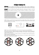
STEP 1) Select TASK/CAMERA in Angle mode, select “WAYPOINT.”
STEP 2) Choose “OK” to accept any pop up warnings/alerts, and to access the
waypoint interface.
WAYPOINT
21
Summary of Contents for H920 PLUS
Page 1: ...V3 0 ...