43
User Manual
4
. User Setting Up
4.1
MAP MENU
To set up the map layout (available only from the chart page):
[MENU]
Zoom Type
E
[MENU] + "ZOOM TYPE" + [ENTER]
Allows larger expansion or compression of the chart scale while zooming in or out.
Zoom Type has two options; Standard (default) or Flexi-Zoom. When in Flexi-
Zoom mode, a short
[ZOOM...]
push causes a change of chart, whilst a long
[ZOOM...]
push (press and hold) causes a pop-up window to be displayed on a
corner of the screen. The window shows the current Zoom Factor. By pressing
[ZOOM IN]
/
[ZOOM OUT]
the map is expanded or compressed according to the
zoom factor selected. The Window is automatically closed if
[ZOOM...]
is not
pressed for 2 seconds and the selected zoom factor will be used at the next zoom
in/out.
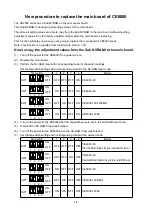
Fonts & Symbols
E
[MENU] + "FONTS & SYMBOLS" + [ENTER]
It is possible to set the size of all names and symbols drawn on the charts,
selecting between Normal size (the regular characters size) and Large size.
NORMAL size
LARGE size
Fig. 4.1 - Example of Normal size (on the left side) and Large side (on the right side) settings
Perspective View
E
[MENU] + "PERSPECTIVE VIEW" + [ENTER]
Chart data may be projected in perspective mode during navigation. This function
allows setting the panoramic view of the chart. As the upper side of the map is
more compressed than the lower side, a wider map area is visible. The Perspec-
tive View
E
allows showing more chart information immediately ahead and around
the cursor.
Summary of Contents for MAP 11csE Plus GPS
Page 3: ...4 User Manual ...
Page 25: ...26 User Manual ...
Page 41: ...42 User Manual ...
Page 59: ...60 User Manual ...
Page 65: ...66 User Manual ...
Page 99: ...100 User Manual ...
Page 113: ...114 User Manual ...