31
User Manual
3.4
USING TRACK
A very useful feature of the chart plotter, is the ability to store and display exactly
where the boat has been. This feature, referred to as Tracking, can provide
invaluable information about the effect of tide and wind influence on the boat's
progress as well as giving an indication of the helmsman's performance.
When this limit has been reached, the oldest points are deleted and overwritten
by the newest ones.
Setting up a Track Step
Before you use the Track function, it is important to specify the Track step unit: if
you select Distance, the Track point is placed when the distance from its last
stored position is greater than the defined distance; if Time, the Track point is
placed after the defined time; if Auto, the software decides when storing a position,
on the basis of the straight or curved track.
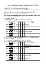
[MENU] + [MENU] + "TRACK" + [ENTER] + "STEP UNIT" + [ENTER] + "DIST"/
"TIME"/"AUTO" + [ENTER]
You can select the Track step Time [ 1, 5, 10, 30
sec; 1, 5, 10 min] or distance
[0.01, 0.05, 0.1, 0.5, 1.0, 2.0, 5.0, 10.0] Nm. Setting a short time/distance
interval between Track points is best suited to navigate within a close or complex
environment, a greater time/distance interval is best suited to a long voyage.
To select the interval at which the Track points are placed:
if you have selected Distance:
[MENU] + [MENU] + "TRACK" + [ENTER] + "DISTANCE" + [ENTER] + choice
the desired step + [ENTER]
if you have selected Time:
[MENU] + [MENU] + "TRACK" + [ENTER] + "TIME" + [ENTER] + choice the
desired step + [ENTER]
Selecting Track Color
To select among different line colors that you choose for the Track:
[MENU] + [MENU] + "TRACK" + [ENTER] + "COLOR" + [ENTER]
The same Track can be saved with any color.
Displaying Track
To enable or disable the Track displaying on the map screen:
[MENU] + [MENU] + "TRACK" + [ENTER] + "VISIBLE" + [ENTER] + "ON"/
"OFF" + [ENTER]
Activating/Deactivating Track Recording
To activate or deactivate the Tracking of the vessel while the vessel is moving:
[MENU] + [MENU] + "TRACK" + [ENTER] + "TRACKING" + [ENTER] + "ON"/
"OFF" + [ENTER]
Clearing Track
All the Track or part of it can be cleared from the screen:
[MENU] + [MENU] + "TRACK" + [ENTER] + "DELETE" + [ENTER] + "YES" +
[ENTER]
Selecting Track Number
The chart plotter has the capability to store up to 2 Tracks. To select a Track:
[MENU] + [MENU] + "TRACK" + [ENTER] + "ACTIVE TRK" + [ENTER] + use
the cursor key to select the [ENTER]
Summary of Contents for MAP 11csE Plus GPS
Page 3: ...4 User Manual ...
Page 25: ...26 User Manual ...
Page 41: ...42 User Manual ...
Page 59: ...60 User Manual ...
Page 65: ...66 User Manual ...
Page 99: ...100 User Manual ...
Page 113: ...114 User Manual ...