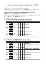
16
User Manual
♦
Official data source
(data based on use of official data sources)
♦
Detailed World Background
(worldwide background chart with details)
♦
Depths & Land Elevation
(color shading of sea depth and land alti-
tude for improved chart reading)
♦
Bathymetric & Spot Soundings
(additional Data Base with depth
and bathy information for an extraordinary view of the seabed depth)
♦
Detailed Port Plan
(complete port and marina charts with detail)
♦
Search & Find
(quickly locates chart contents and objects)
♦
Tides Preview
(dynamic simulation of tides)
♦
Dynamic Currents
(current arrows dynamically display direction and
speed)
♦
Dynamic Nav-Aids
(displays Nav-Aids in true color and with real in-
terval lighting)
♦
Port Info
(all the information of the available services in the ports and
how to contact them)
♦
Enhanced Port Info & Roads
(details of the available facilities and
services in ports and surrounding areas)
♦
Object Info
(indicates restricted area details and related information)
♦
Quick Info
(full information on objects, buoys, wrecks, shoals and
Nav-Aids)
♦
Photos & Diagrams
(high definition pictures of ports, piers, bridge
diagrams and nav-aids)
♦
Multilanguage Support
(displays charts in the local character set)
♦
True-Type Font
(improves text on chart for optimal reading)
Presentation Features
♦
Clear View
(advanced legibility techniques providing more chart data
on the screen)
♦
Clear Info
(sophisticated "Human Dictionary" to translate Nav-Aid ab-
breviations found on paper charts)
♦
Dynamic Nav-Aids
(an innovative and dynamic presentation mode)
♦
Flexi-Zoom
(increased Under and Over Zoom between chart levels,
resulting in optimal scale display for any situation)
♦
Dynamic Elevation Data
(optimized palettes including the NOAA color
palette)
♦
Perspective View
("Real World" perspective view of the chart, up-
dated real-time during navigation)
♦
Smooth-Zoom
(smooth transition of cartographic levels)
♦
Enhanced Turbo-Zoom
(extra fast cartography level change display-
ing the most important cartographic objects)
♦
Enhanced Mixing Levels
(seamless data presentation)
♦
Off-line redraw
(cartography level transition without image
construction)
Cartographic Data related Features
♦
Guardian Alarm
(automatic control and alarm over obstacles on charts
in front of your boat)
♦
Safety Toolbar
(interactive alarm system for situational awareness on
screen)
♦
Safety Route Check
(sophisticated function checking dangerous ob-
jects along your navigation route)
Summary of Contents for MAP 11csE Plus GPS
Page 3: ...4 User Manual ...
Page 25: ...26 User Manual ...
Page 41: ...42 User Manual ...
Page 59: ...60 User Manual ...
Page 65: ...66 User Manual ...
Page 99: ...100 User Manual ...
Page 113: ...114 User Manual ...