


12
LD2342 V1.4 Page 12 of 22
SRT Marine Technology
User guide
SRT-MTB
©
proAIS Application
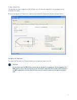
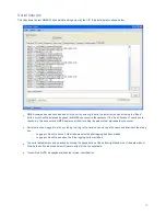
GPS Status tab
This tab shows the status of the internal GPS receiver. If the GPS receiver has position fix then the current position, speed and
course are shown. A bar chart of satellite signal strength is also provided.
Satellite signal strength bars are shown in green for satellites that are currently being used for navigation. Blue signal strength
bars are used to show satellites not currently being used for navigation. Red bars indicate SBAS* (WAAS or EGNOS) satellites
used for improved GPS accuracy in some areas. It is normal for the graph to display a combination of green and blue bars,
along with Red bars in an area with SBAS coverage.
The information on this tab is intended for use during installation of the AIS Transceiver in order to verify connection of the GPS
antenna.
*Support for SBAS (WAAS / EGNOS) is dependant on the configuration and software version in your Transceiver.
Summary of Contents for AIS500
Page 1: ...LD2342 V1 4 Page 1 of 22 SRT Marine Technology...
Page 2: ...2 LD2342 V1 4 Page 2 of 22 SRT Marine Technology User guide SRT MTB proAIS Application...
Page 20: ...20 LD2342 V1 4 Page 20 of 22 SRT Marine Technology User guide SRT MTB proAIS Application...
Page 23: ...LD2342 V1 4 Page 23 of 22 SRT Marine Technology User guide SRT MTB proAIS Application...


