10
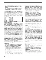
• Press the MOTOR SPEED button on the hand controller.
The LCD will display the current speed rate in the upper
right corner.
• Press the number on the hand control that corresponds to
the desired speed. (You do not need to press ENTER to
activate the change.)
The hand controller has a “double button” feature that allows
you to instantly speed up the motors without having to choose
a speed rate. To use this feature, simply press the arrow button
that corresponds to the direction that you want to move the
telescope. While holding that button down, press the opposite
directional button. This will increase the speed to the maxi-
mum slew rate.
1 = 2x
6 = .5° / sec
2 = 4x
7 = 1° / sec
3 = 8x
8 = 2° / sec
4 = 16x
9 = 4° / sec
5 = 32x
Nine available slew speeds
alignment Procedure
In order for the StarSeeker to accurately point to objects in
the sky, it must first be aligned to known positions in the sky.
With this information, the telescope can create a model of the
sky, which it uses to locate any object with known coordinates.
There are many ways to align the StarSeeker with the sky
depending on what information the user is able to provide. All
methods require you to enter your current date, time, and city
to create an accurate model of the sky. With
SkyAlign sim-
ply point the telescope to any three bright celestial objects to
accurately align the telescope with the sky.
Auto Two-Star
Align will ask the user to choose and center the first alignment
star, then the StarSeeker will automatically select and slew to
a second star for alignment.
Two-Star Alignment requires the
user to identify and manually slew the telescope to the two
alignment stars.
One-Star Align requires you to align to just
one known star. Although not as accurate as the other align-
ment methods, One-Star Align is the quickest way to find and
track bright planets and objects in Altazimuth mode. Finally,
Solar System Align will display a list of visible daytime objects
(planets and the Moon) available to align the telescope. Each
alignment method is discussed in detail below.
Note: Before performing an alignment, be sure that the
EZ Finder II is properly aligned with the telescope.
Initial Set-up
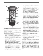
1. Power on the StarSeeker by plugging the power supply
into the jack on the base of the fork arm (
Figure 10).
2. Press ENTER to choose SkyAlign. You will be able
to choose a different alignment method in the future.
Pressing the ALIGN button will bypass the other
alignment options and the scrolling text and automatically
begins SkyAlign.
3. The hand controller display will then ask for the following
time/site information:
Location – The StarSeeker will display a list of cities to
choose from. Choose the city from the database that is
closest to your current observing site. The city you choose
will be remembered in the hand controller’s memory so
that it will be automatically displayed the next time an
alignment is done. Alternatively, if you know the exact
longitude and latitude of your observing site, it can be
entered directly into the hand controller and remembered
for future use as well. To choose a location city:
• Use the Up and Down scroll buttons to choose
between City Database and Custom Site. City
Database will allow you to select the closest city to
your observing site from a list of either international
or U.S. location. Custom Site allows you to enter the
exact longitude and latitude of your observing site.
Select City Database and press ENTER.
• The hand controller will allow you to choose from either
U.S. or international locations. For a listing of U.S.
locations by state and then by city, press ENTER while
United States is displayed. For international locations,
use the Up or Down scroll button to select International
and press ENTER.
• Use the Up and Down Scroll buttons to choose your
current state (or country if International locations
was selected) from the alphabetical listing and press
ENTER.
• Use the Up and Down Scroll buttons to choose the
closest city to your location from the displayed list and
press ENTER.
If you choose to enter the latitudinal and longitudinal
position, use the numeric keypad and scroll buttons. This
method can provide greater accuracy when targeting
objects in the night sky. First enter the longitudinal coor-
dinate and hemisphere (W or E), followed by the latitudi-
nal coordinate and hemisphere (N or S). Press ENTER to
confirm your coordinates.
Note: Latitude and longitude coordinates must be
entered in degrees and arcminutes. If your map
or atlas gives coordinates in decimal values (i.e.,
latitude = 36.95 N) you must convert into degrees
and arcminutes. To do this simply multiply the deci-
mal value by 60. If your viewing location is at lati-
tude 36.95 N you would enter a latitude of 36°57’ N
[.95x60=57].
Time – Enter the current time for your area. You can enter
either the local time (i.e., 8:00), or you can enter military
time (i.e., 20:00).
• Select PM or AM. If military time was entered, the hand
control will bypass this step.
• Choose between Standard time or Daylight Saving
time. Use the Up and Down scroll buttons to toggle
between options.
• Select the time zone that you are observing from.
Again, use the Up and Down buttons to scroll through
the choices. For time zone information, refer to the
Time Zone map in the appendices of this manual.
Summary of Contents for 8993
Page 27: ...27 Appendix C Time Zones ...


