74
To configure a map fix:
To use this format, you need to follow these steps in order. First, take
your map of the area and determine a reference latitude/longitude.
(Note: in order for this system to work, the latitude/longitude lines
must be parallel with the edge of the map. USGS maps are parallel,
others may not be. Also, this works better with smaller scale maps,
such as 1:24000.) The reference position can be anywhere on the map,
but the closer it is to your location, the smaller the numbers will be
that you'll have to deal with.
Once you've decided on a reference position, you can save it as a way-
point. See the waypoint section for information on saving a waypoint.
Save the reference position as a waypoint. Exit from the waypoint
screens.
1. Press
MENU
|
MENU
|
↓
to
GPS S
ETUP
|
ENT
.
2. Press
↓
to
C
OORDINATE
S
YSTEM
|
ENT
.
3. Press
↓
to
S
ETUP
M
AP
F
IX
|
ENT
.
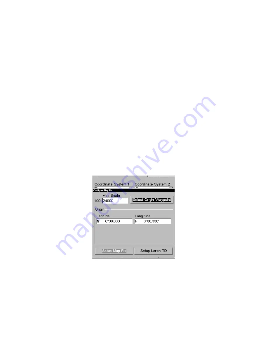
The screen below appears, and
M
AP
S
CALE
is highlighted. Press
ENT
and
enter the map's scale. This is generally at the bottom of the paper map.
It's shown as a ratio, for example 1:24000. Press
EXIT
and the unit re-
turns to the Configure Map Fix screen.
Configure a map fix so the unit can find your position on a printed
chart or topographical map.
Press
→
to
S
ELECT
O
RIGIN
|
ENT
|
ENT
|
ENT
to bring up the waypoint list.
Select the waypoint that you saved the reference point under and press
ENT
. The unit displays a waypoint information screen with the com-
mand
S
ET
A
S
O
RIGIN
selected; press
ENT
and the unit returns to the Con-
figure Map Fix menu. Finally, press
EXIT
to erase this menu. Now press
↑
to
C
OORD
S
YSTEM
|
ENT
, select
M
AP
F
IX
from the list and press
ENT
|
EXIT
.
Summary of Contents for GlobalMap 3500C
Page 1: ...Pub 988 0156 081 www lowrance com GlobalMap 3500C Mapping GPS Receiver Operation Instructions...
Page 16: ...10 Notes...
Page 28: ...22 Notes...
Page 74: ...68 Notes...
Page 122: ...116 Notes...
Page 128: ...122 Notes...
Page 129: ...123 Notes...
Page 130: ...124 Notes...