background image

34 


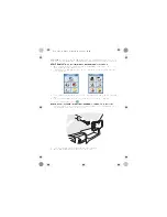
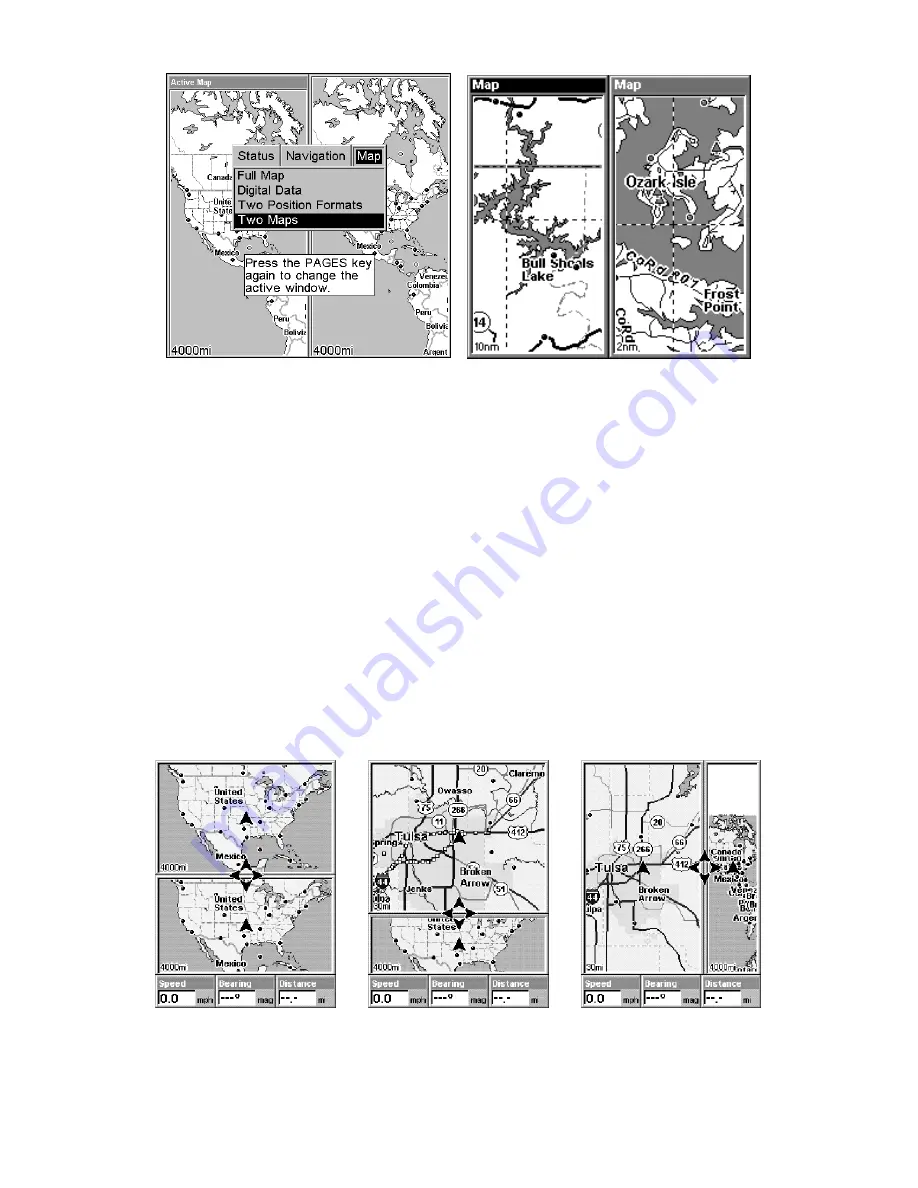
Pages Menu with Two Map option selected, left. 

Map Page with two map windows, at right. The left map is active. 

Resize Window is another extremely handy feature for pages that have 
two major windows. You can change the relative size of the windows, as 
well as horizontal or vertical layout, to suit your viewing preference. 
Here's how: 

1. From any two-window display, press


MENU

|

 to


R

ESIZE


W

INDOW

|

ENT

2. Four flashing arrows appear along the centerline dividing the two 
windows. Press an arrow key perpendicular to the centerline to adjust 
the window widths. Press an arrow key parallel to the centerline to 
switch between horizontal and vertical layout. (You can only change 
size, not switch layout, on the Map With Sonar page - it's always two 
vertical windows.) 

Press


EXIT

 to clear the four flashing arrows. 


From left to right, after selecting Resize Window command: Fig. 1. Two 

Maps page display with four flashing arrows on the dividing center-

line. Fig. 2. The centerline has been moved down to enlarge the top 

Fig. 1 

Fig. 2 

Fig. 3 

Summary of Contents for GlobalMap 3500C

Page 1: ...Pub 988 0156 081 www lowrance com GlobalMap 3500C Mapping GPS Receiver Operation Instructions...

Page 2: ...k of Fishing Hot Spots Inc Navionics is a registered trademark of Navionics Inc eXitSource Database copyright 2001 2003 Zenrin Co Ltd Exit Authority and eXitSource are trademarks of Zenrin Co Ltd Lowr...

Page 3: ...3 Basic GPS Operations 23 Keyboard 23 Power lights on and off 24 Main Menu 24 Pages 26 Satellite Status Page 26 Navigation Page 28 Map Page 30 Background map vs MapCreate map content 31 Resize Window...

Page 4: ...a Route 58 Delete a Route 61 Edit a Route Name 61 Edit Route Waypoints 61 Navigate a Route 62 Navigate a Route in Reverse 62 Trails 63 Delete a Trail 63 Edit a Trail Name 64 Edit a Trail Color 64 Edit...

Page 5: ...Datum Selection 80 Map Detail Category Selection 80 Map Orientation 81 Navionics Charts 82 To display a Navionics chart 83 Port Information 83 To view Port Services information 83 Tidal Current Infor...

Page 6: ...path to the waypoint It provides navigation data to the waypoint regardless of obstructions Therefore the prudent navigator will not only take advantage of all available navigation tools when traveli...

Page 7: ...ormation you want At the start or end of each segment we ll tell you what content is coming up next If it s a concept you re already familiar with we ll show you how and where to skip ahead for the ne...

Page 8: ...duce a search example in the Basic GPS Operation section but there are so many map items you can search for we had to give this function its own sec tion in the manual For example did you know this un...

Page 9: ...enhanced detail of continental U S and Hawaii Includes more than 60 000 nav aids and 10 000 wrecks obstructions in coastal and Great Lakes waters Metro ar eas selected major streets highways and in t...

Page 10: ...on Accessories on page 11 If you re new to GPS read on and you can later impress your friends with your new found knowl edge First think of your unit as a small but powerful computer But don t worry w...

Page 11: ...00C has one more thing in common with a personal computer Just as computers have a floppy disk drive for storing and ex changing files the unit has a slot for an MMC MultiMedia Card or SDC Secure Digi...

Page 12: ...days a year all weather global navigation system for the armed forces of the U S and its allies Civilian use was also available at first but it was less accurate because the military scram bled the si...

Page 13: ...on Speed direction of travel and distance are all calculated from position information Therefore in order for the GlobalMap 3500C to determine direction of travel you must be moving and the faster the...

Page 14: ...ompass Also remember that this unit will always show navigation information in the shortest line from your present position to a waypoint regardless of terrain It only calculates position it can t kno...

Page 15: ...rail would look like this 1 From the Map Page press MENU MENU to MY TRAILS ENT 2 Press to Trail 1 ENT to NAVIGATE ENT 3 You are asked to wait while it converts the trail into a route 4 The wait messag...

Page 16: ...10 Notes...

Page 17: ...ion for the GPS antenna module and its cable route 3 Determine the location of your battery or other power connection along with the power cable route 4 Install the GPS antenna and route the antenna c...

Page 18: ...y simply placing the external antenna on the top of the dash at the base of the windshield A piece of the rubber non skid shelf liner material available in recreational vehicle supply stores will help...

Page 19: ...owing segment for connecting your unit s Power Supply cable The NMEA 2000 Power cable s red wire should be attached with provided 3 amp fuse to the boat battery s positive terminal and the NMEA 2000 P...

Page 20: ...s pecially when the power cable is disconnected from the unit If possible keep the power cable away from other boat wiring especially the engine s wires This will provide the best isolation from elect...

Page 21: ...arm to the user when not properly fused CAUTION Do not use this product without a 3 amp fuse wired into the power cable Failure to use a 3 amp fuse will void your warranty This unit has reverse polari...

Page 22: ...1 wiring to receive NMEA position information from some other GPS receiver Com 1 wiring to transmit NMEA position information to another NMEA compatible device Mounting the Unit Bracket In Dash or Po...

Page 23: ...iewing angle You should also make sure there is enough room behind the GlobalMap 3500C to attach the power and GPS antenna receiver module cables A drawing on the next page shows the dimensions of a g...

Page 24: ...you wish you can fill in the hole around the cables with a good marine caulking compound Some marine dealers stock cable hole covers to con ceal the opening No matter what type of installation you pr...

Page 25: ...n Like many Lowrance products the GlobalMap 3500C is capable of port able operation by using an optional portable power pack The power pack and the magnet equipped antenna module expand the uses for y...

Page 26: ...onal MMC cards are available from LEI Extras see ordering in formation inside the back cover of this manual MMCs and SD cards are also available at many camera and consumer electronics stores The MMC...

Page 27: ...e the acces sory ordering information on the inside back cover of this manual MapCreate 6 CD ROM left MMC card reader for USB ports right Now that you have your GlobalMap 3500C installed move on to Se...

Page 28: ...22 Notes...

Page 29: ...t s a good idea to learn about the different keys the four Page screens and how they all work together BUT if you just can t wait to get outside turn to the one page Quick Reference on page 36 Keyboar...

Page 30: ...lets you zoom the screen out This lets you see a larger geographic area on the map Less detail is seen as you zoom out 9 ZIN Zoom In This key lets you zoom the screen in Zooming in lets you see great...

Page 31: ...ute Planning command used to plan view or navigate a route My Trails command shows hides creates and deletes plot trails Also used to navigate or backtrack a trail Cancel Navigation command turns off...

Page 32: ...atus Page shown provides detailed information on the status of the unit s satellite lock on and position acquisition To get to the Satellite Status Page Press the PAGES key then use or to select STATU...

Page 33: ...e bar graphs one for each satellite in view Since the unit has twelve channels it can dedicate one channel per visible satellite The taller the bar on the graph the better the unit is receiving the si...

Page 34: ...not navigating to a waypoint following a route or backtracking a trail When navigating to a waypoint the Navigation screen looks like the following figure Your ground speed track distance and bearing...

Page 35: ...ourse line is shown on the Navigation Page screen and the Map Page screen as a dotted line Navigation Page going to a waypoint while creating a new trail The cross track error range is shown on the co...

Page 36: ...ap Page The Map Page screens show your course and track from a bird s eye view By default this unit shows the map with north always at the top of the screen This can be changed See the topic Map Orien...

Page 37: ...d your own high detail custom map made with MapCreate or a pre made FreedomMap from LEI and you can zoom in to 0 02 miles with mas sive amounts of accurate map detail Map Pages with high detail MapCre...

Page 38: ...scale map detail that allows your GPS unit to show a higher level of position accuracy For example the background map would show you the general outline and approximate shape of a coastline or water b...

Page 39: ...turned off you can still search for POIs and their icons will pop up when your unit finds them for you The Map Page has its own menu which is used for several functions and for setting various option...

Page 40: ...ing arrows appear along the centerline dividing the two windows Press an arrow key perpendicular to the centerline to adjust the window widths Press an arrow key parallel to the centerline to switch b...

Page 41: ...just follow the steps above Most dual window displays use half the screen for each window by default You can also use the Reset Op tions command to revert to the factory default The following page con...

Page 42: ...y Zoom in closer to see greater detail press ZIN zoom in key Zoom out to see more area less detail press ZOUT zoom out key Scroll map north south east or west using arrow keys To stop scrolling and re...

Page 43: ...er left corner of the screen 1 Press the ZIN key zoom in to move in closer and see greater detail in a smaller geographic area 2 Press the ZOUT key zoom out to move farther away and see less map detai...

Page 44: ...back to your current position on the map When you want to take another peek at that distant place just press EXIT again You can use this trick to toggle between your cur rent position and your destina...

Page 45: ...wish you could scroll or here to select another restaurant but for now we will just accept the nearest one Press ENT 5 The POI information screen appears This is how you can use this unit as a busines...

Page 46: ...you are searching loaded on the MMC you may not find anything Set a Waypoint A waypoint is simply an electronic address based on the latitude and longitude of a position on the earth A waypoint repre...

Page 47: ...point screen seen in Step 2 and set a point Step 3 a message says the waypoint has been saved Step 4 ve hicle continues on its way number waypoint symbol is visible on map NOTE The Quick Save method u...

Page 48: ...The waypoint is saved and automatically given a name with a sequential number such as waypoint 001 The waypoint symbol and number appear on the map and in the waypoint list Navigate to a Waypoint You...

Page 49: ...o activate it press the ZOUT and ZIN keys at the same time Your position at the time these keys are pressed is used as the man overboard position Caution Saving a new Man Overboard waypoint will overw...

Page 50: ...gation information Navigate to Cursor Position on Map The GO TO CURSOR command navigates to the current cursor position on the map It s a quick and handy way to navigate to anything you can see on the...

Page 51: ...necting your current position to your destination The 40 mile zoom center shows both current position and destination on screen The Navigation Page right will also show navigation information To stop...

Page 52: ...lid line extending from the back of the current position arrow The unit is set at the factory to automatically create and record a trail while the unit is turned on The unit will continue recording th...

Page 53: ...ive Trail Name ENT 3 Press to ACTIVE ENT This unchecks the Active option 4 To return to the previous page press EXIT EXIT EXIT EXIT As you leave the Edit Trail menu you will notice that a new trail st...

Page 54: ...aved Trails List visible trails have a check mark in front of the trail name To turn off trail display 1 Press MENU MENU to MY TRAILS ENT 2 Press to enter the Saved Trail list then use or to select th...

Page 55: ...in moving and watch the Map Page Simply walk or steer so that your current position arrow traces along the trail you have just made Tip Generally when using this method the smaller the zoom range the...

Page 56: ...ating is represented by a dot ted line that alternates with a flashing solid line The Navigation Page will also show the navigated trail as a dotted line The bearing arrow on the compass rose points t...

Page 57: ...naviga tion information to point 7 which is 2 02 miles away Navigate a Back Trail backtrack or reverse 1 Press MENU MENU to MY TRAILS ENT 2 Press to enter the Saved Trail list then use or to select th...

Page 58: ...on inserting an MMC into the unit see Sec 2 Installation Accessories NOTE To load a Navionics chart see Sec 5 for the entry Navionics Charts GPS Data files GPS Data Files contain waypoints routes trai...

Page 59: ...ss to LOAD ENT 3 Saving to MMC To accept the default name Data for the GPS Data File press to SAVE DATA ENT If you wish to rename the file as shown in the following figures press ENT to activate the s...

Page 60: ...y a com pletion message when the data transfer is finished To return to the Page view press EXIT EXIT EXIT EXIT These figures show the menu sequence for loading a GPS Data File from an MMC into the un...

Page 61: ...es At right the distance from the boat s current position to the boat ramp is 0 52 miles Find Distance From Point to Point You can also measure distance between two other points on the map 1 While on...

Page 62: ...at your current position while you are navigating Create Icon on Map 1 Use the arrow keys to move the cursor to the place where you want to make an icon 2 Press ENT and the screen shows a Select Icon...

Page 63: ...e the cursor over an icon to select it After selecting the icon press ENT and it disap pears from the map Navigate to an Icon Use the Navigate to Cursor command and use the cursor to select the desire...

Page 64: ...he easiest method for preparing a route simply because your PC s larger screen keyboard and mouse are easier to manipulate than the unit To load a MapCreate route into the unit follow instructions in...

Page 65: ...eys and arrow keys to move the map and cursor until the cursor is centered on the spot where you want your route to begin If you are starting at your current position or the current cursor posi tion y...

Page 66: ...t 5 ends the route at a tree stand in the hunting area Fig 6 Press EXIT to save the route and you return to this screen 5 Move the cursor to the next point in the route a spot where you need to turn o...

Page 67: ...1 From the NAVIGATION PAGE press MENU ENT or from the MAP PAGE press MENU MENU to ROUTE PLANNING ENT 2 Press to route name ENT ENT 3 Press or to change the first character then press to move the curso...

Page 68: ...o select End of route before adding them Navigate a Route 1 From the NAVIGATION PAGE press MENU ENT or from the MAP PAGE press MENU MENU to ROUTE PLANNING ENT Selecting the Route Planning command on M...

Page 69: ...alarm has been triggered and the bearing arrow on the compass rose has turned to point toward Wpt 2 off to the east In Fig 3 the traveler has turned east on his new course and is heading straight for...

Page 70: ...up box appears Press WPT and the Edit Trail menu opens At left trail selected with map cursor The pop up box shows distance and bearing from current position to the selected point on the trail At righ...

Page 71: ...U LATIONS ENT Trip Calculator To get to the Calculator menu press MENU MENU to TRIP CALCULA TOR ENT Trip Down Timer To get to the Down Timer menu press MENU MENU to TIMERS ENT to DOWN TIMER ENT Trip U...

Page 72: ...ENT To return to the previous page press EXIT EXIT EXIT EXIT Waypoint Position To edit waypoint position 1 Press WPT ENT ENT ENT to waypoint name ENT to EDIT WAY POINT ENT 2 Latitude press to LATITUD...

Page 73: ...lected from your waypoint list a map feature or from the Points of In terest list 1 Press WPT to SUBCATEGORY column to NEW ENT 2 Press to PROJECTED POSITION ENT to CREATE ENT 3 Press to CHOOSE REFERE...

Page 74: ...68 Notes...

Page 75: ...e to the waypoint For example if the alarm is set to 1 mile then the alarm flashes a message if you drift 1 of a mile or more to the right or left of the line to the waypoint The anchor alarm is trigg...

Page 76: ...or only those satellites When your GPS receiver is turned on for the first time it doesn t know what your position or elevation altitude is It does know the current UTC time and date since these were...

Page 77: ...com port can be used for NMEA data transfer Menus for changing Com Port settings For connectors and wiring information for another device see page 16 For assistance in configuring the unit to communi...

Page 78: ...te System Selection 1 Press MENU MENU to GPS SETUP ENT 2 Press to COORDINATE SYSTEM ENT This unit can show a position in degrees 36 14952 degrees minutes and thousandths of a minute 36 28 700 or degre...

Page 79: ...to highlight the desired for mat Press ENT to select it Press EXIT to erase the menus To setup Loran TD NOTE If the Loran TD conversion is chosen you must enter the local Lo ran chain identification...

Page 80: ...as a waypoint Exit from the waypoint screens 1 Press MENU MENU to GPS SETUP ENT 2 Press to COORDINATE SYSTEM ENT 3 Press to SETUP MAP FIX ENT The screen below appears and MAP SCALE is highlighted Pres...

Page 81: ...MENU to CUSTOM IZE ENT A data box name flashes indicating it is selected Press ENT to change the box or hit or to select another box then press ENT You ll see a list of categories with or symbols nex...

Page 82: ...dialog boxes provided on the simulator menu screen To get to the GPS Simulator 1 Press MENU MENU to GPS SETUP ENT 2 Press to GPS SIMULATOR ENT The GPS Simulator Menu appears GPS Simulator menu Make t...

Page 83: ...t your destination cancel navigation as you normally do Tip You can pick any spot on the map to begin your simulation session by using the Initialize GPS command This makes your unit think it s locate...

Page 84: ...rn this feature on from the MAP PAGE press MENU to AUTO ZOOM ENT EXIT Repeat these steps to turn it off Map Data This menu lets you turn the map off if desired which turns the map screen into a GPS pl...

Page 85: ...are handy for visually estimating distances on the map The ring diameters are based on the current zoom range For example at the 100 mile zoom the screen will show two rings with your current positio...

Page 86: ...change the datum 1 Press MENU MENU to GPS SETUP ENT to DATUM SELECTION ENT 2 Scroll or to select the desired datum then press ENT 3 To return to the last page displayed press EXIT EXIT A list of the d...

Page 87: ...ou re always traveling due north What you see to your left corresponds to the left side of the map to your right is shown on the right side of the map and so on However if you travel any other directi...

Page 88: ...to return to the page display Map Menu left Map Orientation menu with the North Up map orientation option selected right NOTE In North Up and Course Up the present position arrow appears in the center...

Page 89: ...ics chart for the Miami area 3 To turn off a Navionics chart From the Map Page press MENU to MAP DATA ENT to NAVIONICS MAP CHOICE ENT Use or to select LOWRANCE then press ENT EXIT EXIT Port Informatio...

Page 90: ...n to the Map Page press EXIT EXIT 4 Depending on the location the Detailed Services window may have a long list of services under the General Services category To scroll through the Detailed Services...

Page 91: ...range the icon itself be comes an animated arrow showing tidal current velocity and direction for the selected tidal station at the present time At larger zoom ranges you can select the boxed C icon a...

Page 92: ...is date at the present time The graph at the top of the screen is an approximate view of the flood and ebb pattern for the day from midnight MN to noon NN to midnight MN The velocity scale at the top...

Page 93: ...ge the icon itself be comes an animated gauge showing a rising or falling tidal height for the selected station at the present time At larger zoom ranges you can se lect the boxed T icon and it become...

Page 94: ...1 Use and to highlight month day or year then press ENT 2 Use and to select the desired month day or year then press ENT To clear the information screen press EXIT Overlay Data On any Page display bu...

Page 95: ...pressing ENT will show the category s contents so you can choose items within it An expanded category one with a next to its name can be collapsed to hide its contents and make more room on your scre...

Page 96: ...displayed Select the item you want to remove from your display and press ENT ENT to re move the data To remove another item select the item and press ENT ENT 3 When you have finished removing all the...

Page 97: ...press EXIT NOTE Some data types can be displayed in only one font size If that is the case the Data Size box will not be displayed for that data type NOTE The Customize command and the Overlay Data co...

Page 98: ...reset all features to their factory defaults 1 Press MENU MENU to SYSTEM SETUP ENT to RESET OPTIONS ENT to YES ENT NOTE Reset Options does not erase any waypoints routes icons or plot trails Reset Opt...

Page 99: ...the display s brightness Press to BRIGHTNESS Press or to move the bar The left end of the scale is minimum contrast the right end is maximum contrast To adjust the screen s display mode Press to DISPL...

Page 100: ...or to select the day then press ENT To set the Year Press to YEAR ENT Press or to select the year then press ENT To set the Date Format Press Press or to select the date for mat then press ENT To set...

Page 101: ...play 3 You can return to this command and press ENT again to turn the fea ture on Software Version Information From time to time Lowrance updates the operating system software in some of its products...

Page 102: ...NDS With the option high lighted press ENT to check it turn on and uncheck it turn off After the option is set press EXIT EXIT to return to the page display To set Alarm Volume Press to VOLUME Press o...

Page 103: ...are updated display or hide trails create a new trail delete a trail etc General Trail Options To access the Trails Menu 1 Press MENU MENU to MY TRAILS ENT Main Menu left Trails Menu center Trail Opt...

Page 104: ...t trail uses all of the available points allotted to it the beginning points are taken away and placed at the end of the trail From the Trails Menu press to TRAIL OPTIONS ENT to UPDATE CRITE RIA Press...

Page 105: ...nit is recording new points for a par ticular trail On the Edit Trail menu press or to highlight the section you wish to change then press ENT Make your changes then press EXIT to erase this menu Rela...

Page 106: ...units To change the units Press MENU MENU to SYSTEM SETUP ENT ENT To set Speed Distance Unit of Measure Press or to change the Speed Distance then press ENT After the option is set press EXIT EXIT EXI...

Page 107: ...unit s varied search functions all begin with either the Find Way point menu or the Map Page menu Press WPT and the Find Waypoint menu appears for waypoints and Points of Interest POI From the Map Pag...

Page 108: ...Jump down to the lower selection list by pressing ENT then press or to select a street name from the list then press ENT The street name you selected is now in the street field Find Address menu left...

Page 109: ...t Search in particular city only option center Find City by name right 6 When the necessary search fields are filled in press to FIND AD DRESS ENT You unit asks you to wait while it searches for the a...

Page 110: ...phone number in the Waypoint Information list With the address location selected by the cursor on the map press WPT The POI s Waypoint Information window ap pears with the Go To Waypoint command high...

Page 111: ...p the Find Exit menu Find Highway Exits command left and Find Exit menu right 2 First select a highway name by pressing ENT which calls up the Find By Name menu There are two highway search options A...

Page 112: ...exit Press to switch to the Exit List then press or until you highlight the exit then press ENT Find Exit menu with an exit selected in the Exit List 4 In the Exit Information screen you have two choi...

Page 113: ...or to se lect Service Name ENT Exit Information screen left general location and amenities information at right Find Map Places or Points of Interest POI 1 Press WPT press or to select a map place or...

Page 114: ...aypoint Information screen Find by Nearest option left Calculating screen center POI list right 3 Search by name of POI Press ENT There are two options A You can spell out the POI in the top selection...

Page 115: ...reen is displayed you can choose to Go To the POI waypoint by pressing ENT or find it on the map by pressing ENT Go To POI option left Find on Map POI option right Find Streets or Intersections Find a...

Page 116: ...can jump down to the lower box and pick a street from the selection list Press ENT then press or to select a street from the list and press ENT Find Street By Name menu Spell out name in the top box o...

Page 117: ...howing results of a street search The cursor points to the located street If you want to navigate to the found street at the cursor location just press MENU ENT EXIT Find an Intersection You must ente...

Page 118: ...tter and repeat until the name is correct then press ENT ENT B Or you can jump down to the lower box and pick the sec ond street from the selection list Press ENT then press or to se lect a street fro...

Page 119: ...tersection just press MENU ENT EXIT Find Waypoints 1 Press WPT ENT 2 If searching for the waypoint By Name press ENT If searching for the Nearest waypoint press to NEAREST ENT To search by name jump t...

Page 120: ...mand is already highlighted The unit will show navigation informa tion to the waypoint B To find the waypoint press to FIND ON MAP ENT The Map Page appears with the cursor highlighting the found wayp...

Page 121: ...ss ENT The waypoint informa tion screen appears Find By Name menu left Waypoint Information screen center At right the found waypoint is highlighted by the cursor on the Map Page A To navigate to the...

Page 122: ...116 Notes...

Page 123: ...and Arc 1950 Zaire Arc 1950 Zambia Arc 1950 Zimbabwe Arc 1960 Mean for Kenya Tanzania Ascension Island 1958 Ascension Island Astro Beacon E 1945 Iwo Jima Astro DOS 71 4 St Helena Island Astro Tern Isl...

Page 124: ...s Ireland Scotland Shetland Islands European 1950 Finland Norway European 1950 Greece European 1950 Iran European 1950 Italy Sardinia European 1950 Sicily European 1950 Malta Ireland 1965 Ireland ISTS...

Page 125: ...North American 1927 Canada New Brunswick New foundland Nova Sco tia Quebec North American 1927 Canada Northwest Territories Sas katchewan North American 1927 Canada Yukon North American 1927 Canal Zon...

Page 126: ...can 1969 Chile South American 1969 Colombia South American 1969 Ecuador South American 1969 Ecuador Baltra Ga lapagos South American 1969 Guyana South American 1969 Paraguay South American 1969 Peru S...

Page 127: ...on against harmful interference in a residential installation This equipment generates uses and can radiate radio frequency energy and if not installed and used in accordance with the in structions ma...

Page 128: ...122 Notes...

Page 129: ...123 Notes...

Page 130: ...124 Notes...

Page 131: ...exclusive nonassignable right to use these Databases for supplemental navigation reference purposes but only as long as you comply with the terms and conditions of this License Agreement We reserve th...

Page 132: ...S BE LIABLE TO ANYONE FOR ANY SPECIAL CONSE QUENTIAL INCIDENTAL OR OTHER INDIRECT DAMAGE OF ANY KIND Some states do not allow the exclusion or limitation of incidental or consequen tial damages so the...

Page 133: ...ENT OR REFUND AS JUST DESCRIBED IS THE EXCLUSIVE REMEDY AVAILABLE TO YOU AGAINST US FOR ANY DEFECT MALFUNCTION OR NON CONFORMITY CONCERNING THE PRODUCT OR FOR ANY LOSS OR DAMAGE RESULTING FROM ANY OTH...

Page 134: ...nge or end our ship ping policies regulations and special offers at any time We reserve the right to do so without notice in Canada If you re in Canada and you have technical return or repair question...

Page 135: ...uct for repair or replacement you must first receive a return authorization number from Customer Service Products shipped without a return authorization will not be accepted When shipping we recommend...

Page 136: ...Visit our web site Lowrance Pub 988 0156 081 Copyright 2004 All Rights Reserved Printed in USA 121704 Lowrance Electronics Inc...

Reviews: