KNA-DV3100/DV3200
12
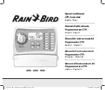
Screen Name : GPS information screen
■
Functions outline
• This screen displays GPS-related information.
• The data is updated when the information displayed
changes.
■
Screen appearance
GPS INFORMATION
ID Elv/Azm St Lev
Data (GMT): 12/31/2002 09 : 46 : 59 HDOP: xx.x
Latitude Longitude Meas. Stat : 3D
N34
°
59´ 5˝ E137
°
30´ 11˝
1 10
°
/010
°
P
52
2 20
°
/020
°
T
49
3 30
°
/030
°
–
0
4 40
°
/040
°
P
49
5 70
°
/300
°
–
0
6 89
°
/359
°
–
0
ID Elv/Azm St Lev
20 53
°
/256
°
P
50
15 11
°
/111
°
T
49
6
1
5
3
2
4
■
Display details
q
Satellite information
• The following information on the satellite as the search ob-
ject is displayed : satellite number (ID); an angle of eleva-
tion (Elv); azimuth reading (Azm); signal level (Lev) and re-
ception state (St).
• The display areas are secured for the maximum of 8 satel-
lites.
• For the reception state, the appropriate letter is displayed
depending on the state.
[P] : When the satellite in question is used for positioning.
[T] : When the satellite in question is spotted but not used
for positioning.
[–] : When the satellite in question is spotted yet.
w
Date and time information
• The date and time information obtained from the GPS re-
ceiver is displayed in : month; day; year; hour; minute; and
second.
e
Position information
• The current latitude and longitude are displayed in : sign,
degree, minute, and second.
As for the sign, appropriate letter is displayed according to
the conditions that apply.
[N] : When the latitude is judged to be north latitude.
[S] : When the latitude is judged to be south latitude.
[W] : When the longitude is judged to be west longitude.
[E] : When the longitude is judged to be east longitude.
r
Positioning condition information
• Positioning conditions are described in the following five
conditions :
[2D] : When positioning is made on two dimensions.
[3D] : When positioning is made on three dimensions.
[NG] : When positioning is not possible..
[error] : When reception error takes place.
[–] : When conditions other than the above occur.
t
HDOP
• The HDOP value at the time of positioning (accuracy value
in the horizontal direction) is displayed in numbers.
LSB 01 display areas: 0.0~99.9
When exceeding 99.9 and when positioning is not con-
ducted, [–] is displayed.
y
The screen returns to the Navigation Information screen.
Screen Name : Adjust position screen
■
Functions outline
• This is the function for adjusting the position to the default
coordinate that is registered on the map disk.
■
Screen appearance
Yes
Map DVD is
inserted
No
Reset
RESET POSITION
Reset
Please insert a map DVD to arrow vehicle position
be reset to the current map DVD default.
Reset
Reset Position
Map DVD is inserted
RESET POSITION
Please press the ‘Reset’ button to reset the vehicle
position to the current map DVD default.
1
1
Make the direction of
the vehicle to 0 degree
(for east).
Adjust the current position.
Return to the Navigation
Information screen.
■
Display details
q
The screen returns to the Navigation Information screen.
TEST MODE