


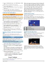

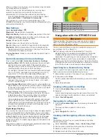


definition and thermocline definition can be better when using a
higher frequency.
Lower frequencies use wider beam widths, which can let the
fisherman see more targets, but could also generate more
surface noise and reduce bottom signal continuity during rough
sea conditions. Wider beam widths generate larger arches for
fish target returns, making them ideal for locating fish. Wider
beam widths also perform better in deep water, because the
lower frequency has better deep water penetration.
CHIRP frequencies allow you to sweep each pulse through a
range of frequencies, resulting in better target separation in
deep water. CHIRP can be used to distinctly identify targets, like
individual fish in a school, and for deep water applications.
CHIRP generally performs better than single frequency
applications. Because some fish targets may show up better
using a fixed frequency, you should consider your goals and
water conditions when using CHIRP frequencies.
Some sonar black boxes and transducers also provide the ability
to customize preset frequencies for each transducer element,
which enables you to change the frequency quickly using the
presets as the water and your goals change.
Viewing two frequencies concurrently using the split-frequency
view allows you to see deeper with the lower frequency return
and, at the same time, see more detail from the higher
frequency return.
Selecting the Transducer Frequency
NOTE:
You cannot adjust the frequency for all sonar views and
transducers.
You can select which frequencies appear on the sonar screen.
NOTICE
Always be aware of local regulations on sonar frequencies. For
example, to protect orca whale pods, you might be prohibited
from using frequencies between 50 to 80 khz with in ½ mile of
an orca whale pod. It is your responsibility to use the device in
compliance with all applicable laws and ordinances.
1
From a sonar view, select
>
Frequency
.
2
Select a frequency suited to your needs and water depth.
For more information on frequencies, see
.
Creating a Waypoint on the Sonar Screen
Using the Device Keys
1
From a sonar view, use the arrow keys to select a location to
save.
2
Select .
3
If necessary, edit the waypoint information.
Pausing the Sonar
Not all options are available on all models.
Select an option:
• From the
Traditional
or
ClearVü
sonar screen, select or
.
• From the
SideVü
sonar screen, select or .
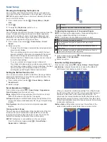
Adjusting the Zoom
You can adjust the zoom manually by specifying the span and a
fixed starting depth. For example, when the depth is 15 m and
the starting depth is 5 m, the device displays a magnified area
from 5 to 20 m deep.
You also can allow the device to adjust the zoom automatically
by specifying a span. The device calculates the zoom area from
the bottom of the water. For example, if you select a span of
10 m, the device displays an magnified area from the bottom of
the water to 10 m above the bottom.
1
From a sonar screen, select
>
Zoom
.
2
Select an option:
• Select
Bottom Lock
to lock the screen to the water
bottom.
• Select
Manual
to manually set the zoom.
• Select
Auto
to automatically set the zoom.
• Select
Split Zoom
to turn on the split-zoom view.
Locking the Screen to the Water Bottom
You can lock the screen to the water bottom. For example, if you
select a span of 20 meters, the device shows an area from the
water bottom to 20 meters above the bottom. The span appears
on the right side.
1
From a sonar view, select
>
Zoom
>
Bottom Lock
.
2
Select a span.
Sonar Gain
The gain setting controls the sensitivity of the sonar receiver to
compensate for water depth and water clarity. Increasing the
gain shows more detail, and decreasing the gain reduces screen
clutter.
NOTE:
Setting the gain on one sonar view applies the setting to
all the views.
Setting the Gain Automatically
NOTE:
To set the gain on the split-frequency screen, you must
set each frequency separately.
1
Select
>
Gain
.
2
Select
Enable Auto Gain
, if applicable.
3
Select an option:
• To display higher-sensitivity, weaker sonar returns with
more noise automatically, select
Auto High
.
• To display medium-sensitivity sonar returns with moderate
noise automatically, select
Auto Med
.
• To display lower-sensitivity sonar returns with less noise
automatically, select
Auto Low
.
Setting the Gain Manually
1
From a sonar screen, select
>
Gain
.
2
Select or until you begin to see noise in the water portion
of the screen.
3
Select or to decrease the gain.
Adjusting the Range of the Depth Scale
You can adjust the range of the depth scale that appears on the
right side of the screen. Automatic ranging keeps the bottom
within the lower third of the sonar screen, and can be useful for
tracking the bottom where there are slow or moderate terrain
changes.
When the depth changes dramatically, like a drop off or cliff,
manually adjusting the range allows a view of a specified depth
range. The bottom is shown on the screen as long as the bottom
is anywhere within the manual range established.
1
From a sonar screen, select
>
Range
.
2
Select an option:
• To allow the device to adjust the range automatically
based on the depth, select Auto.
• To increase the range manually, select or .
• To decrease the range manually, select or .
NOTE:
From a sonar screen, select and to quickly
manually adjust the range.
Setting the range on one screen applies that setting to all
screens, except the SideVü screen.
Sonar Fishfinder
5