background image

2

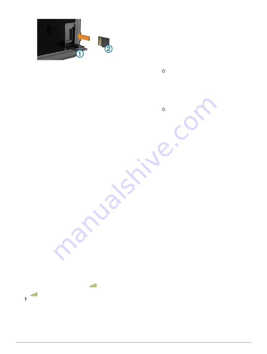
Insert the memory card 

Á

 with the label facing to the right.

3

Press the card in until it clicks.

4

Close the door.

Loading the New Software on a Memory 

Card

The device may contain a software-update memory card. If so, 

follow the instructions provided with the card. If a software 

update memory card is not included, you must copy the 

software update to a memory card.

1

Insert a memory card into the card slot on the computer.

2

Go to 

www.garmin.com/support/software/marine.html

.

3

Select 

Download

 next to “Garmin Marine Network with SD 

card.”

4

Read and agree to the terms.

5

Select 

Download

.

6

Select 

Run

.

7

Select the drive associated with the memory card, and select 

Next

 > 

Finish

.

Updating the Device Software

Before you can update the software, you must obtain a 

software-update memory card or load the latest software onto a 

memory card.

1

Turn on the chartplotter.

2

After the home screen appears, insert the memory card into 

the card slot.

NOTE: 

In order for the software update instructions to 

appear, the device must be fully booted before the card is 

inserted.

3

Follow the on-screen instructions.

4

Wait several minutes while the software update process 

completes.
The device returns to normal operation after the software 

update process is complete.

5

Remove the memory card.

NOTE: 

If the memory card is removed before the device 

restarts fully, the software update is not complete.

GPS Satellite Signals

When you turn on the chartplotter, the GPS receiver must 

collect satellite data and establish the current location. When 

the chartplotter acquires satellite signals, 

 appears at the top 

of the Home screen. When the chartplotter loses satellite 

signals, 

 disappears and a flashing question mark appears 

over   on the chart.
For more information about GPS, go to 

www.garmin.com

/aboutGPS

.

Selecting the GPS Source

You can select your preferred source for GPS data, if you have 

more than one GPS source.

1

Select 

Settings

 > 

System

 > 

GPS

 > 

Source

.

2

Select the source for GPS data.

Setting the Vessel Type

You can select your boat type to configure the chartplotter 

settings and to use features customized for your boat type.

1

Select 

Settings

 > 

My Vessel

 > 

Vessel Type

.

2

Select 

Powerboat

 or 

Sailboat

.

Adjusting the Backlight

1

Select 

Settings

 > 

System

 > 

Display

 > 

Backlight

.

TIP: 

Press   from any screen to open the backlight settings.

2

Select an option:
• Adjust the backlight level.
• Select 

Auto Backlight

.

Adjusting the Color Mode

1

Select 

Settings

 > 

System

 > 

Display

 > 

Color Mode

.

TIP: 

Press   from any screen to access the color settings.

2

Select an option.

Customizing the Home Screen

You can add items to and rearrange items on the Home screen.

1

From the Home screen, select 

Customize Home

.

2

Select an option:
• To rearrange an item, select 

Rearrange

, select the item 

to move, and select the new location.

• To add an item to the Home screen, select 

Add

, and 

select the new item.

• To remove an item you have added to the Home screen, 

select 

Remove

, and select the item.

Hiding and Showing the Menu Bar

NOTE: 

This feature is not available on all chartplotter models.

You can hide the menu bar automatically to make more screen 

space available.

1

Select 

Settings

 > 

System

 > 

Display

 > 

Menu Bar Display

 > 

Auto Hide

.

After a short period of time on a main page, such as a chart, 

the menu bar collapses down.

2

Swipe the screen from the bottom up to show the menu bar 

again.

Using the Garmin Helm™ App with the 

Chartplotter

Before you can control the chartplotter with the Garmin Helm 

app, you must download and install the application, and connect 

the chartplotter to a mobile device (

Connecting a Wireless 

Device to the Chartplotter

).

1

Select 

Settings

 > 

Communications

 > 

Wireless Devices

 > 

Helm App

.

2

Select an option.

3

Use the application to view or control the chartplotter.

Communication with Wireless Devices

The chartplotters can create a wireless network to which you 

can connect wireless devices. Also, some models can connect 

to Bluetooth® wireless devices using the AVRCP profile.

Setting Up the Wi

Fi® Wireless Network

The chartplotters can create a Wi

Fi network to which you can 

connect wireless devices. The first time you access the wireless 

network settings, you are prompted to set up the network.

2

Introduction

Summary of Contents for nuvi 500-Series

Page 1: ...GPSMAP 500 700 Series and echoMAP 50 70 Series Owner s Manual June 2014 190 01556 10_0C Printed in Taiwan...

Page 2: ...sidiaries These trademarks may not be used without the express permission of Garmin Android is a trademark of Google Inc The Bluetooth word mark and logos are owned by the Bluetooth SIG Inc and any us...

Page 3: ...ings 9 Navigation with a Chartplotter 9 Basic Navigation Questions 9 Destinations 9 Searching for a Destination by Name 9 Selecting a Destination Using the Navigation Chart 9 Searching for a Destinati...

Page 4: ...nizing the Fuel Data with the Actual Vessel Fuel 22 Setting the Fuel Alarm 22 Viewing the Wind Gauges 22 Configuring the Sailing Wind Gauge 22 Configuring the Speed Source 22 Configuring the Heading S...

Page 5: ...ng Data from a Memory Card 29 Copying Waypoints Routes and Tracks to a Memory Card 29 Copying Waypoints Routes and Tracks to or from all Chartplotters on the Network 29 Copying Built In Maps to a Memo...

Page 6: ......

Page 7: ...port 2 Select Manuals 3 Follow the on screen instructions to download the manual for your product Manual Conventions In this manual the term select is used to describe these actions Touching an item o...

Page 8: ...Vessel Type You can select your boat type to configure the chartplotter settings and to use features customized for your boat type 1 Select Settings My Vessel Vessel Type 2 Select Powerboat or Sailboa...

Page 9: ...d This view is helpful when navigating tricky shoals reefs bridges or channels and is beneficial when trying to identify entry and exit routes in unfamiliar harbors or anchorages Mariner s Eye 3D Show...

Page 10: ...options that appear vary based on the location or object you selected 2 Select an option To view details of objects in the vicinity of the cursor select Review NOTE Review does not appear if the curso...

Page 11: ...igation or Fishing chart select Menu Chart Setup Tides Currents 2 Select an option To show current station indicators and tide station indicators on the chart select On To show animated tide station i...

Page 12: ...e target is calculated based on the course over ground information Showing AIS Vessels on a Chart or 3D Chart View Before you can use AIS you must connect the chartplotter to an external AIS device an...

Page 13: ...or applicable premium charts From the Navigation chart or Fishing chart select Menu Chart Setup Satellite Photos Shows high resolution satellite images on the land or on both land and sea portions of...

Page 14: ...to or more shallow than the dangerous depth are indicated by red text Safety Shading Sets the shades from the shoreline to the specified depth Depth Range Shading Specifies an upper and lower depth to...

Page 15: ...To See Creating and Navigating a Route From Your Present Location How do I make the device steer my automatic pilot Navigate using Route To See Creating and Navigating a Route From Your Present Locati...

Page 16: ...magenta line steering to avoid land shallow water and other obstacles 4 If you are off course follow the purple line corrected course to go to your destination or steer back to the magenta line direc...

Page 17: ...e To Route To 3 Select the location of the last turn before the destination 4 Select Add Turn 5 If necessary repeat step 3 and 4 to add additional turns working backward from the destination to the pr...

Page 18: ...iew select Menu Waypoints Tracks Tracks On A trailing line on the chart indicates your track Setting the Color of the Active Track 1 Select Nav Info Tracks Active Track Options Track Color 2 Select a...

Page 19: ...Menu 4 Select an option To change the name select Name and enter a new name To customize the numbers shown on the screen select Overlay Numbers To change the data shown in the combination select Edit...

Page 20: ...e side of the screen shows a full view graph of high frequency sonar data and the other side of the screen shows a full view graph of lower frequency sonar data NOTE The split frequency sonar view req...

Page 21: ...lly select Up or Down To allow the chartplotter to adjust the gain or brightness automatically select an automatic option Adjusting the Color Intensity You can adjust the intensity of colors and highl...

Page 22: ...gher frequency return Selecting Frequencies NOTE You cannot adjust the frequency for all sonar views and transducers You can indicate which frequencies appear on the sonar screen 1 From a sonar view s...

Page 23: ...ntation of the SideV sonar view when the transducer is installed backward Sonar Alarm Settings NOTE Some settings require external accessories Select Settings Alarms Sonar Shallow Water Sets an alarm...

Page 24: ...signals can increase the clutter on the Radar screen and make it more difficult to view information about shorter range targets In rain shorter range radar signals can enable you to view information a...

Page 25: ...on point of the VRM and the EBL 2 Select Drop VRM EBL 3 Select Stop Panning Measuring the Range and Bearing to a Target Object Before you can adjust the VRM and the EBL you must show them on the Radar...

Page 26: ...ence on the Radar Screen Side lobe interference may appear to streak outward from a target in a semi circular pattern Side lobe effects can be avoided by reducing the gain or reducing the radar range...

Page 27: ...nfigured for use in one radar mode is applied to every other radar mode and to the Radar overlay 1 From a Radar screen or the Radar overlay select Menu Radar Setup Front of Boat 2 Select Up or Down to...

Page 28: ...e you can set a fuel level alarm a compatible fuel flow sensor must be connected to the NMEA 2000 network You can set an alarm to sound when the total amount of remaining onboard fuel reaches the leve...

Page 29: ...mation for today select Change Date Current If available to view information for the day after the date shown select Next Day If available to view information for the day before the date shown select...

Page 30: ...a Navigation chart marking the location select Next Page To view the position report details select Previous Page Navigating to a Tracked Vessel 1 Select Nav Info Other Vessels DSC List 2 Select a po...

Page 31: ...Media Player You can wirelessly connect the media player to a Bluetooth device 1 Place the Bluetooth device within 33 ft 10 m of the media player 2 From the media screen select BT Devices or Bluetooth...

Page 32: ...not fill the entire screen To show the video using a standard aspect ratio select Aspect Standard To adjust the brightness select Brightness and select Up Down or Auto To adjust the color saturation...

Page 33: ...ne forecasts coastal forecasts and offshore forecasts Weather bulletins may consist of either weather watches or weather advisories To view information about the warning or bulletin select the shaded...

Page 34: ...ilable on all devices and in all subscriptions 1 From the weather Fishing chart select Weather Fishing Menu Fish Species 2 Select a species of fish 3 Select On 4 Repeat steps 2 and 3 to show areas wit...

Page 35: ...ata from MapSource to the prepared memory card For more information see the MapSource help file Copying Data from a Memory Card 1 Insert a memory card into a card slot 2 Select Nav Info Manage Data Da...

Page 36: ...y hides the menu bar when it is not needed GPS Settings Select Settings System GPS Skyview Shows the relative position of GPS satellites in the sky GLONASS Turns on or off GLONASS usage Russia satelli...

Page 37: ...ing colder than it actually is Enter this value in step 5 as a negative number if the sensor connected to the chartplotter measures the water temperature as being warmer than it actually is 4 Select S...

Page 38: ...map is structured Do not change this setting unless you are using a map or chart that specifies a different map datum Pressure Ref Time Sets the reference time used to calculate the barometer trend T...

Page 39: ...tion through a narrow waterway 8 Select an option If the placement of the Auto Guidance line is satisfactory select Menu Stop Navigation and proceed to step 10 If the Auto Guidance line is too close t...

Page 40: ...oltage is less than 10 volts the device will not turn on If the device is receiving enough power but does not turn on contact Garmin product support at www garmin com support My device is not creating...

Page 41: ...02 AIS safety related broadcast message 129808 DSC call information 130310 Environmental parameters 130311 Environmental parameters obsolete 130313 Humidity 130314 Actual pressure 130576 Small craft s...

Page 42: ...anning 3 setup 7 fuel alarm 22 32 fuel capacity 22 30 fuel gauges 21 22 configuring 22 status alarm 22 32 synchronizing with actual fuel 22 fuel onboard 30 G Garmin Marine Network 13 31 Garmin product...

Page 43: ...ews 13 14 waypoint 14 whiteline 17 zoom 15 SOS 10 24 suspended targets 9 symbols 5 synchronizing user data 13 system information 30 T tide stations 5 23 indicators 5 touchscreen 1 calibrating 33 track...

Page 44: ...02 36 699699 52 001 855 792 7671 0800 0233937 47 815 69 555 00800 4412 454 44 2380 662 915 35 1214 447 460 386 4 27 92 500 0861 GARMIN 427 646 27 0 11 251 9999 34 93 275 44 97 46 7744 52020 886 2 2642...

Reviews: