background image

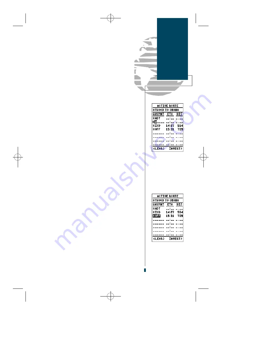
Once  you’ve selected  a  waypoint from  the route  list,

choose a menu function:

1. To review the definition page for the waypoint, highlight the

‘review’ field and press 

E

.

2. To add a new waypoint that precedes the selected way-

point, highlight the ‘insert’ field and press 

E

.

3. To remove the selected waypoint, highlight the ‘remove’

field and press the 

E

key.

4. To replace the selected waypoint with a new 

waypoint, highlight the ‘change’ field and press 

E

.

Use the waypoint editing instructions described earlier

(see  page  30)  for  creating  a  route to  complete  your
changes. If you’re editing the active route (route 0), copy
the new route version to an empty route to save it, as it
will be overwritten by a new route activation. If you add,
delete or change the first or last waypoint of a route, the
default comment (first and last waypoint) will automati-
cally be updated after your changes.

At  the  beginning of the  route  section,  we  mentioned

that  the  GPS  90  will automatically  select  the  route leg
closest  to  your  position  as  the  active  leg.  This  will  give
you steering guidance to the ‘active to’ waypoint of that
leg,  based  on  the desired  track  of the active  leg.  If  you
would prefer to  navigate  directly  towards  the ‘active
f rom’  waypoint,  you  can  perf o rm an  ‘on-route  GOTO’
right from the active route page.

To perform an on-route GOTO:

1. Use the 

U

and 

D

keys to highlight the desired route

waypoint and press the 

G

key.

2. Once the GOTO Page appears, press 

E

to confirm the

on-route GOTO waypoint.

Once you reach the GOTO waypoint, the GPS 90 will

resume  navigation  of  the  rest  of the  active  route  in
sequence.

33

Routes

Editing Routes

On-Route

GOTOs

Inserting a new route
waypoint.

Select the route way-
point you want to
navigate to and press
the GOTO key.

gps 90 manual  8/6/98 9:59 AM  Page 33

Summary of Contents for GPS 90

Page 1: ...GOTO NRST QUIT WPT ENTER PAGE GPS90 Personal NavigatorTM Owner s Manual Reference gps 90 manual 8 6 98 9 41 AM Page 1...

Page 2: ...gps 90 manual 8 6 98 9 57 AM Page 2...

Page 3: ...any purpose without the express written permission of GARMIN Information in this document is subject to change without notice GARMIN reserves the right to change or improve their products and to make...

Page 4: ...and used in in accordance with the instructions may cause harmful interference to radio communications However there is no guarantee that interference will not occur in a particular installation If t...

Page 5: ...here you ll learn how to turn the unit on and off use the airport and waypoint database select and navigate to a destination and use the moving map page in flight The tour is the fastest way to get th...

Page 6: ...e Advanced Navigating and Plotting Large moving map display with Auto Zoom and SUA boundaries Internal Jeppesen database includes detailed airport information includ ing runway length surface and ligh...

Page 7: ...Receiver Carrying Case and Wrist Strap Universal Yoke Mount Bracket Suction Cup Antenna Mount Cable DC Power Cable 4 AA Batteries GPS 90 Owner s Manual Quick Reference Card Warranty Card Country Airp...

Page 8: ...gps 90 manual 8 6 98 9 57 AM Page vi...

Page 9: ...Menu 43 50 Map Configuration Menu 51 Alarms CDI Menu 52 54 E6 B Menu 55 59 User Waypoints List Messages 60 Simulator 61 62 Appendix A Initialization 63 Appendix B Installation 64 65 Appendix C Batteri...

Page 10: ...g the position of any 3 or 4 of these satellites and calculating various time differences between the transmitted signals your GPS receiver can determine its present position anywhere on earth And onc...

Page 11: ...the earth that pass through the north and south poles Longitude describes position in terms of how many degrees it is east or west of the Prime Meridian 0 longitude Parallels of latitude are another s...

Page 12: ...GOTO twice activates the NRST mode B The POWER key turns the unit on and off and activates screen backlighting To turn the unit off press and hold the POWER key for 3 seconds Q The QUIT key returns y...

Page 13: ...pear listing the issue date of the internal aviation database After a few seconds the Database Information page will be replaced with the Satellite Status page The Status page provides a visual refere...

Page 14: ...move the field highlight to the Setup Menu option 3 Press the Ekey 4 The setup menu will appear with the Operation Mode option highlighted Press the Ekey 5 Once the Operation Mode page appears use th...

Page 15: ...ht the next step is to select our GOTO destination Lakeway Airport 3R9 in Austin Texas 1 Press the Gkey 2 The GOTO Page will appear with the waypoint identifier field ready to accept changes 3 Use the...

Page 16: ...5 000 feet 4 Press Eto confirm the altitude The GPS 90 Position page displays your present lati tude longitude and altitude along with your current track and speed over the ground The top of the page...

Page 17: ...the cursor to the default position Once you ve zoomed in to the 40 nm scale you ll be able to see a clear presentation of your plane nearby air ports and the special use airspace around Mueller Munici...

Page 18: ...the desired direction and press E to activate the function or review the selected waypoint Try selecting KAUS located just to the right of your current route to practice 1 With the field cursor on th...

Page 19: ...tional frequencies Once you have moved from the initial page of an air port review the prompt highlight will automatically move forward to the next available prompt This allows you to continuously scr...

Page 20: ...ou ve made your way through the Takeoff Tour To view the SUA message 1 Press the Pkey 2 To return to the Map page press Pagain Additional information including the name class controlling agency and al...

Page 21: ...y viewing the nearest airports to our present position 1 Press the Gkey twice to display the nearest page 2 Press Eto begin selection of the desired category 3 Press theDkey repeatedly to scroll throu...

Page 22: ...out beyond the AutoZoom scale the Autozoom will be cancelled and the GPS 90 will assume you want to stay at the scale you have manually selected For more information on the AutoZoom feature please see...

Page 23: ...w the sections on initialization installa tion and the internal database so you can get the most out of your new GPS The rest of the manual is organized as a topical reference so you may quickly find...

Page 24: ...16 gps 90 manual 8 6 98 9 58 AM Page 16...

Page 25: ...name position lat lon and frequency Intersections Identifier region country position lat lon and range bearing to nearest VOR User Identifier name position lat lon user comments and reference waypoin...

Page 26: ...ired waypoint is displayed press E Once you ve selected a waypoint category waypoint information can also be retrieved by entering the facility name of the airport the name of the VOR or NDB or their...

Page 27: ...port page initially displayed will be the same as the last airport page viewed 2 Use the Lkey to move the field highlight to the desired page prompt and press E Once you have moved from the initial ai...

Page 28: ...r Jet A MOGAS 87 octane unleaded The airport communication page shown in the left margin displays radio frequencies and their usage for the selected airport and allows entry of a desired airport by id...

Page 29: ...time full time pilot controlled with frequency no lighting or unknown If a selected airport has more than one runway addi tional runways can be viewed by selecting another run way from the designation...

Page 30: ...also be displayed at the bottom of the page to help you confirm the location in the event of duplicate identifiers NDB INFORMATION The next waypoint category in the GPS 90 s internal database is NDB f...

Page 31: ...so displayed with the region and country indicated at the bottom of the page USER WAYPOINT INFORMATION The last waypoint category available from the GPS 90 s WPT key is user waypoints The user waypoin...

Page 32: ...move to the position field where you can manually enter the position of the new waypoint 1 Press E to begin entry of the waypoint position 2 Use the arrow keypad to enter the lat lon The Land Rkeys wi...

Page 33: ...default user comment the date and time of cre ation to the new waypoint You can change the default comment to a custom comment at any time right from the user waypoint page To enter a user comment 1 U...

Page 34: ...Press the Mkey twice to capture your position if you re already on a waypoint page you ll only need to press the Mkey once The AutoStore page will appear showing the captured position and a default 3...

Page 35: ...few basic concepts and terms that apply to all point to point GPS navigation Routes are broken down and navigated in smaller segments called legs The dia gram above shows a basic route consisting of f...

Page 36: ...you enter waypoint characters the screen will automatically display the first numerical or alphabetical match of the character you have entered To use the Spell N Find feature 1 Press the Lkey to cle...

Page 37: ...waypoints for each route with fields for desired track and distance between legs if the leg distance exceeds 999 nm the field will remain blank Below the waypoint list are the route page function fiel...

Page 38: ...entering all your waypoints press Pto return to the Menu page The route definition page is also used to copy a route to another route number This feature is useful when you make changes to the active...

Page 39: ...needed and will be retained in its original format under its existing route number This system allows you to have an active route that you may edit during navigation and save as an entirely new route...

Page 40: ...t to the invert field 2 Press the Ekey to invert the route To clear the active route from the Active Route Page and stop route navigation 1 Use the Uand Lkeys to select the clear field 2 Press E Highl...

Page 41: ...fault comment first and last waypoint will automati cally be updated after your changes At the beginning of the route section we mentioned that the GPS 90 will automatically select the route leg close...

Page 42: ...ion acquiring satellites and using the GPS 90 in other applications hunting fish ing hiking etc please see Appendix A D Receiver status is indicated at the top left of the screen with the current hori...

Page 43: ...t off and back on SIMULATOR the unit is in simulator mode Below the receiver status field and to the left of the satellite sky view is the battery level indicator which will display the battery life l...

Page 44: ...lat lon may pre vent the receiver from tracking the correct set of satellites for your position To manually enter a position 1 Press theD key until the position field is highlighted 2 Press Eto begin...

Page 45: ...nted as squares with the waypoint name also listed You may select which of these features are shown through the map setup submenu page see page 51 for more information The speed distance and angle fie...

Page 46: ...p To activate the pan function 1 From the zoom field use the Rkey to highlight the pan field 2 Press the Ekey to activate the pan function 3 Use the arrow keys to move the map in any direction As you...

Page 47: ...into the map field 2 Once you are in the map field use the four arrow keys to scroll through on screen waypoints The arrow key you use will determine the direction of your scroll 3 When you have scro...

Page 48: ...sshair to mark a new waypoint position or as a GOTO destination right from the map field To mark the target crosshair position as a new waypoint 1 Press the Mkey to capture the position 2 Enter a new...

Page 49: ...ap scale is manually zoomed in before an AutoZoom takes place the automatic scaling will resume once it reaches the scale you have selected If the map scale is manually changed to a setting higher tha...

Page 50: ...modes display and other settings to meet your specific preferences To select a submenu from the setup menu simply highlight the desired listing and press the Ekey The first setup page is the operation...

Page 51: ...e the field highlight to the mode field and press E 2 Use the arrow keypad to choose a mode and press E The initial position field allows you to define a starting point for simulated trips or name an...

Page 52: ...nu where you can select preferences for position format nav units heading calculations and map datum The default position setting is latitude and longitude in degrees and minutes hddd mm mmm You may a...

Page 53: ...ap datum 1 Move the field highlight to the datum field and press E 2 Use the arrow keypad to toggle through and select the desired setting Confirm the setting by pressing E The next listing available...

Page 54: ...e the arrow keypads to select the desired setting Confirm the setting by pressing the Ekey The Date Time menu provides access to the local time offset and timer functions The date and time field is lo...

Page 55: ...in the count Up setting highlight the time field and press E 2 Press the Lkey to reset the field or use the arrow keypad to enter a starting time for the timer Press Eto finish and restart the timer T...

Page 56: ...log Use the Lkey to move the field high light to the yes field 3 Press Eto clear the track log The next listing available from the setup menu is the Input Output setup page where you can specify the...

Page 57: ...ow the GPS 90 to accept DGPS corrections in RTCM 104 version 2 0 format The RTCM NONE format will allow connection to any manually tuned beacon receiver with the proper interface with the baud rate se...

Page 58: ...unway used to calculate the nearest airports The options for runway surfaces are Any Default setting any runway regardless of sur face type including water landing facilities Hard Only Only runways wi...

Page 59: ...e alert messages for an airspace category For more on SUAs see pages 52 53 The third section of the configuration page controls the map s route and track log features The ROUTES field lets you select...

Page 60: ...your current course will take you inside a SUA near ahead message will be displayed 3 If you have entered an SUA a Inside SUA mes sage will be displayed 4 If you are within 2 nm of an SUA and your cu...

Page 61: ...y 2 Press the Ekey 3 Use the arrow keypad to select the on or off position 4 Press the Ekey The ALT BUF field located directly below the SUA alarm settings is an altitude buffer that allows you to set...

Page 62: ...ack alarm and define the course devia tion indicator scale The CDI alarm will provide amessage when your crosstrack error exceeds a specified distance To set the CDI alarm 1 Highlight the CDI ALARM fi...

Page 63: ...air temperature gauge on most piston aircraft and press the Ekey The calculated density altitude and true airspeed will be displayed at the bottom of the page The GPS 90 winds aloft function will calc...

Page 64: ...aypoint 6 Enter the destination waypoint and press E 7 Press Eto begin entry of the trip speed 8 Enter the trip speed and press E The field highlight will advance to the Flow field 9 Press Eto begin e...

Page 65: ...unction available is the sunrise sun set calculator which will allow you to calculate the sunrise and sunset for any known waypoint or your pre sent position for a specific date To calculate sunrise s...

Page 66: ...desired final altitude and press E 5 Press Eto begin entry of the offset the distance from the waypoint you ll be referencing for your final altitude 6 Press Eand use the arrow keypad to select the Be...

Page 67: ...e From field and vertical speed required the At field to complete the maneuver When the recommended altitude is within 1 000 feet of the final altitude you ll be informed with a Final Altitude Alert m...

Page 68: ...gain To delete all user waypoints 1 Use the arrow keypad to highlight the DELETE ALL WPTS prompt and press E 2 Use the Lkey to move the field highlight to the Yes prompt on the delete waypoints confir...

Page 69: ...e page appears use the Dkey to highlight the Current Mode field 6 Press Eto begin selection of the operating mode 7 Use the Uand Dkeys to toggle through and select the Simulator option 8 Press E to co...

Page 70: ...ed field and press E 4 Enter a speed and press E 5 Highlight the position field and press E 6 Enter a position and press the Ekey The GPS 90 does not track satellites in simulator mode Although you ca...

Page 71: ...ou take off You wait for an initial position to be computed If you turn the unit off before acquiring a position it may increase the time to first fix the next time you power the unit up If you want t...

Page 72: ...to the control yoke on most aircraft 1 Loosen the lower mounting knob 2 Slide the clamp over the yoke shaft just behind the control wheel and tighten the lower knob securely 3 Make sure the clamp is...

Page 73: ...d extension cable and mount ed to the inside of your windscreen Remember to attach the antenna and cable where it does not block your vision of primary instruments and does not interfere with yoke con...

Page 74: ...s will be affected To install batteries 1 Remove the battery cover by turning the thumb loop 1 4 turn counter clockwise 2 Insert batteries into position The battery pole you can still see should match...

Page 75: ...B GPRMC GPXTE GPVTG GPWPL Proprietary sentences PGRMM map datum PGRMZ altitude PSLIB beacon rec control NMEA 0183 version 2 0 Approved sentences GPGGA GPGLL GPGSA GPGSV GPRMB GPRMC GPRTE GPWPL Proprie...

Page 76: ...the unit on See pages 5 66 and 67 for more information Why does my GPS 90 come on in Searching the Sky mode with an All Stored Data Lost message When a GPS 90 loses all waypoint and satellite data a...

Page 77: ...he GPS may not know position or time the satellite data stored in memory can help the unit obtain a posi tion fix without going through the satellite constellation sequentially Your unit is shipped in...

Page 78: ...ented in the correct position and there are no buildings or other significant structures to block the satellite signals Once the GPS has determined your posi tion it can usually provide accurate upda...

Page 79: ...rovide years of reliable service without any rou tine maintenance or adjustments If the unit has been stored without batteries or you have encountered a problem that was not solved by the troubleshoot...

Page 80: ...t uses land based radio beacons to transmit position corrections to GPS receivers Estimated Time of Arrival ETA The time of day of your arrival at a desti nation Estimated Time Enroute ETE The time le...

Page 81: ...hat projects global sections onto a flat surface to measure position in specific zones Velocity Made Good VMG The speed you are clos ing in on a destination along a desired course 73 Appendix E Glossa...

Page 82: ...e minute away from reaching a destination waypoint Arrival At You are within the arrival alarm circle of the indicated waypoint Battery Power is Low The AA batteries are low and should be replaced Can...

Page 83: ...t position shown by other means Read Only Mem has Failed The permanent memory has failed and the unit is not operable Take your unit to an authorized GARMIN dealer for repairs Received an Invalid WPT...

Page 84: ...l waypoints routes and almanac data has been lost due to battery failure SUA Ahead 10 min Your projected course and current altitude will place you within an SUA within 10 minutes based on your curren...

Page 85: ...Zone Offset W007 5 to E007 5 0 E007 5 to E022 5 1 E022 5 to E037 5 2 E037 5 to E052 5 3 E052 5 to E067 5 4 E067 5 to E082 5 5 E082 5 to E097 5 6 E097 5 to E112 5 7 E112 5 to E127 5 8 E127 5 to E142 5...

Page 86: ...sland Indonesia Dos 1968 Dos 1968 Gizo Island New Georgia Islands Easter Isld 67 Easter Island 1967 European 1950 European 1950 Austria Belgium Denmark Finland France Germany Gibraltar Greece Italy Lu...

Page 87: ...yptian Old Egyptian Egypt Old Hawaiian Old Hawaiian Mean Value Oman Oman Oman Ord Srvy GB Old Survey Grt Britn England Isle of Man Scotland Shetland Isl Wales Pico De Las Nv Canary Islands Ptcairn Ast...

Page 88: ...gps 90 manual 8 6 98 10 02 AM Page 80...

Page 89: ...imated Time of Arrival ETA 72 Estimated Time Enroute ETE 72 G Glossary 72 73 GOTO Function 28 GPS Overview 2 Ground Speed 72 H Heading Reference 45 I Initialization 63 Initial Position Reference 44 In...

Page 90: ...nway Page Airport 21 S Satellite Status Page 34 35 Searching the Sky 35 Simulator Mode 61 62 Sky View Display 35 Spell N Find 28 Sunrise Sunset Calculation 57 T Time Setup 46 77 Tone Setup 46 Track 73...

Page 91: ...gps 90 manual 8 6 98 10 02 AM Page 83...

Page 92: ...GARMIN INTERNATIONAL 9875 Widmer Road Lenexa KS 66215 USA GARMIN Europe LTD Robert House Station Approach Romsey Hampshire SO51 8DU UK Part Number 190 00084 00 Rev A gps 90 manual 8 6 98 10 02 AM Pag...

Reviews: