Other Vessels Layer Settings
NOTE: These options require connected accessories, such as an AIS receiver or VHF radio.
From a chart, select > Layers > Other Vessels.
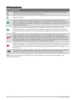
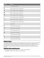
DSC: Sets how DSC vessels and trails appear on the chart, and shows the DSC list.
AIS: Sets how AIS vessels and trails appear on the chart, and shows the AIS list.
Details: Shows other vessel details on the chart.
Proj. Heading: Sets the projected heading time for AIS-activated vessels.
Collision Alarm: Sets the safe-zone collision alarm (
Setting the Safe-Zone Collision Alarm, page 24
).
Water Layer Settings
From a chart, select > Layers > Water.
NOTE: The menu may contain some settings that are not supported by your installed charts or your present
location. If you make changes to those settings, the changes will not impact the chart view.
NOTE: Not all settings apply to all charts, views, and chartplotter models. Some options require premium maps
or connected accessories.
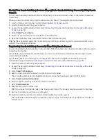
Depth Shading: Specifies an upper and lower depth to shade between (
).
Shallow Shading: Sets the shades from the shoreline to the specified depth.
Spot Depths: Turns on spot soundings and sets a dangerous depth. Spot depths that are equal to or more
shallow than the dangerous depth are indicated by red text.
Fishing Contours: Sets the zoom level for a detailed view of bottom contours and depth soundings and
simplifies map presentation for optimal use while fishing.
Relief Shading: Shows the gradient of the bottom with shading. This feature is available only with some
premium maps.
Sonar Imagery: Shows sonar imagery to help show the density of the bottom. This feature is available only with
some premium maps.
Lake Level: Sets the present water level of the lake. This feature is available only with some premium maps.
Charts and 3D Chart Views
29
Summary of Contents for ECHOMAP UHD2 6 SV
Page 1: ...ECHOMAP UHD26 7 9SV Owner sManual...
Page 10: ......
Page 151: ......
Page 152: ...support garmin com GUID 900F784C 8371 433B B263 67611C27A94C v1 January 2023...


