background image

Arriving at Your Destination

When you approach your destination, the device provides 

information to help you complete your route.

 indicates the location of your destination on the map, and a 

voice prompt announces you are approaching your 

destination.

• When you approach some destinations, the device 

automatically prompts you to search for parking. You can 

select Yes to find nearby parking areas (

Parking Near Your 

Destination

, page 4

).

• When you must park or stop a longer distance from your 

destination, you can continue to your destination on foot 

using your Garmin DriveSmart device or a compatible Garmin 

watch with Connect IQ

 (

Finding Your Destination Using 

Your Garmin Watch

, page 4

).

• When you stop at your destination, the device automatically 

ends the route. If the device does not detect your arrival 

automatically, you can select Stop to end your route.

Parking Near Your Destination

Your device can help you find a parking spot near your 

destination. When you approach some destinations, the device 

automatically prompts you to search for parking.

1

Select an option:
• When the device prompts you, select 

Yes

 to search for 

nearby parking.

• If the device does not prompt you, select 

Where To?

 > 

Categories

 > 

Parking

, and select   > 

My Destination

.

2

Select 

Filter Parking

, and select one or more categories to 

filter parking by availability, type, price, or payment methods 

(optional).

NOTE: 

Detailed parking data is not available in all areas or 

for all parking locations.

3

Select a parking location, and select 

Go!

 > 

Add As Next 

Stop

.

The device guides you to the parking area.
After you park your vehicle, you can continue to your destination 

on foot using your Garmin DriveSmart device or a compatible 

Garmin watch with Connect IQ (

Finding Your Destination Using 

Your Garmin Watch

, page 4

). Your device or Garmin watch 

can also guide you back to this parking spot when you return to 

your vehicle (

Finding Your Last Parking Spot

, page 4

).

Finding Your Destination Using Your Garmin Watch

Before you can use this feature, you must set up Watch Link 

(

Setting Up Watch Link

, page 15

).

You can use your compatible Garmin watch to navigate from 

your vehicle to your destination, or from your destination back to 

your vehicle. This feature is especially useful for finding a 

location within a large venue, or when you have to park away 

from your destination and finish navigating on foot.

NOTE: 

GPS technology requires a clear view of the sky. The 

Watch Link app may not be able to provide guidance in indoor 

venues, such as shopping malls or airports.

1

On your watch, start the Watch Link app, and select 

Find My 

Destination

.

Your watch acquires a GPS signal and starts guiding you to 

your destination.

2

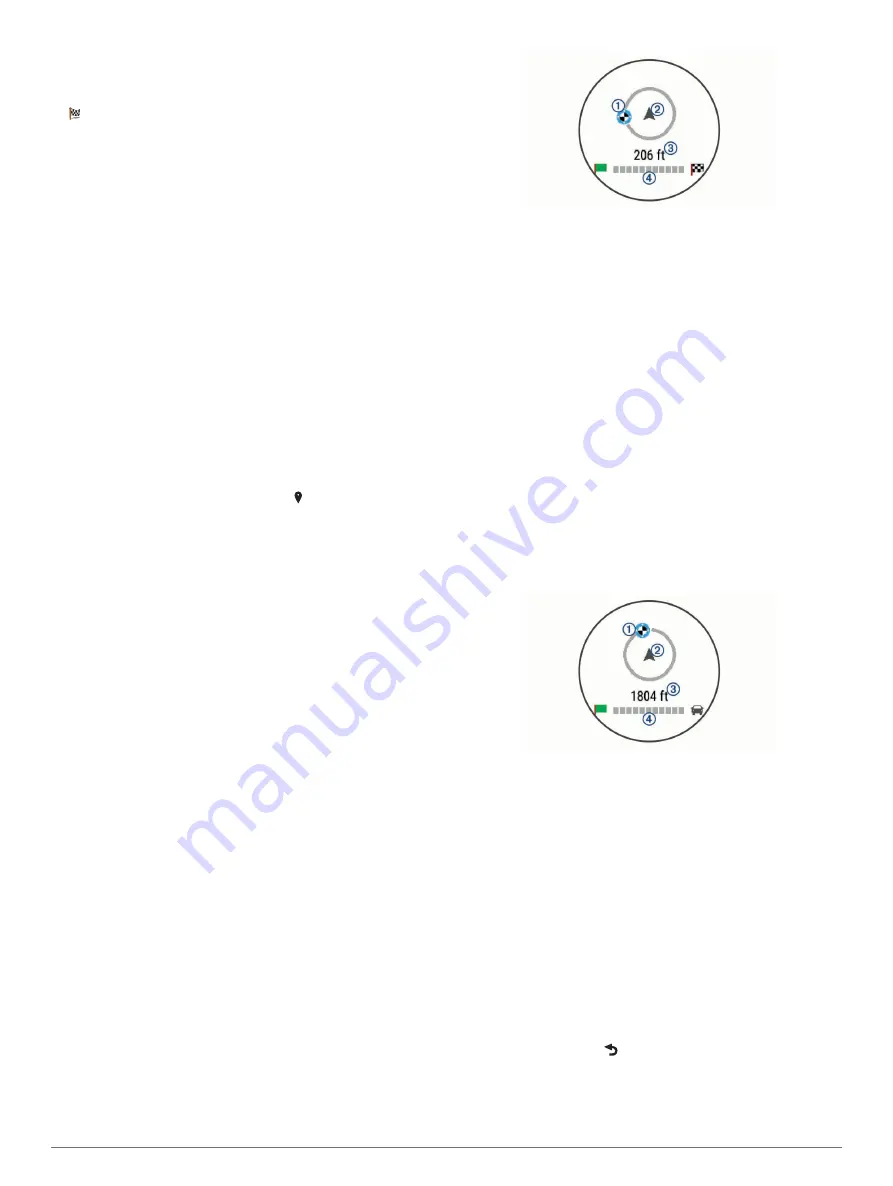
Walk toward your destination.

The destination indicator 

À

 shows the direction of your 

destination relative to the direction you are moving 

Á

. When 

the destination indicator appears at the top of the circle, you 

are heading toward your destination. The remaining distance 

to your destination 

Â

 appears below the circle. The progress 

bar 

Ã

 shows your progress toward your destination.

Finding Your Last Parking Spot

When you disconnect your Garmin DriveSmart device from 

vehicle power, it saves your current location as a parking spot. If 

you have set up Watch Link, the device sends the parking spot 

location to your compatible Garmin watch (

Setting Up Watch 

Link

, page 15

). You can navigate back to your parking spot 

using either your Garmin DriveSmart device or the Watch Link 

app on your watch.

TIP: 

If your Garmin DriveSmart device is connected to a 

switched power outlet, it saves your parking spot each time you 

turn off your vehicle. If your device is connected to an non-

switched power outlet, you must unplug the vehicle power cable 

to save your parking spot.
• On your Garmin DriveSmart device, select 

Apps

 > 

Last Spot 

Go!

.

• On your watch, start the Watch Link app, select 

Find My Car

and walk toward your parking spot.

The destination indicator 

À

 shows the direction of your 

destination relative to the direction you are moving 

Á

. When 

the destination indicator appears at the top of the circle, you 

are heading toward your destination. The remaining distance 

to your destination 

Â

 appears below the circle. The progress 

bar 

Ã

 shows your progress toward your destination.

Changing Your Active Route

Adding a Location to Your Route

Before you can add a location to your route, you must be 

navigating a route (

Starting a Route

, page 3

).

You can add locations to the middle or end of your route. For 

example, you can add a fuel station as the next destination in 

your route.

TIP: 

To create complex routes with multiple destinations or 

scheduled stops, you can use the trip planner to plan, schedule, 

and save a trip (

Planning a Trip

, page 17

).

1

From the map, select   > 

Where To?

.

2

Search for a location (

Finding and Saving Locations

page 6

).

3

Select a location.

4

Select 

Go!

.

4

Navigating to Your Destination

Summary of Contents for DriveSmart 51

Page 1: ...NDRIVESMART 51 61 Owner sManual Questo manuale d istruzione fornito da trovaprezzi it Scopri tutte le offerte per Garmin DriveSmart 61LMT D o cerca il tuo prodotto tra le migliori offerte di Navigator...

Page 2: ...Guarantee and n Maps Lifetime are trademarks of Garmin Ltd or its subsidiaries These trademarks may not be used without the express permission of Garmin Android is a trademark of Google Inc Apple and...

Page 3: ...oordinates 8 Foursquare 8 Connecting to Your Foursquare Account 8 Searching Foursquare Points of Interest 8 Viewing Foursquare Location Details 8 Checking in with Foursquare 8 TripAdvisor 8 Finding Tr...

Page 4: ...18 Navigation Settings 18 Calculation Mode Settings 18 Setting a Simulated Location 18 Wireless Network Settings 18 Driver Assistance Settings 18 Backup Camera Settings 18 babyCam Settings 19 Display...

Page 5: ...e until it clicks 6 Plug the other end of the vehicle power cable into a power outlet in your vehicle Turning the Device On or Off To turn the device on press the power key or connect the device to po...

Page 6: ...information for each alert You can enable or disable the audible tone for some types of driver alerts Not all alerts are available in all areas School zone or nearby school The device plays a tone and...

Page 7: ...rkers or a blue dot appear on the map 4 Select an option Select a location marker Select a point such as a street intersection or address location 5 Select Go Going Home The first time you start a rou...

Page 8: ...ination and finish navigating on foot NOTE GPS technology requires a clear view of the sky The Watch Link app may not be able to provide guidance in indoor venues such as shopping malls or airports 1...

Page 9: ...least one location and enable the travel history feature Device and Privacy Settings page 19 Using the myTrends feature your device predicts your destination based on your travel history the day of t...

Page 10: ...e 6 Search and check into Foursquare points of interest Searching Foursquare Points of Interest page 8 Use search tools to find specific locations such as addresses intersections or geographic coordin...

Page 11: ...ditional search results Select to view another location Selected location summary Select to view detailed information about the selected location Go Select to start navigating to the location using th...

Page 12: ...to Smartphone Link page 11 2 On your smartphone open the Smartphone Link app 3 Open the Smartphone Link app settings and select Foursquare Login 4 Enter your Foursquare login information Searching Fo...

Page 13: ...Select Edit Categories 5 Enter one or more category names separated by commas 6 If necessary select a suggested category 7 Select Done Deleting a Saved Location NOTE Deleted locations cannot be recov...

Page 14: ...add the tool to the map tools menu Enabling Map Tools page 10 From the map select Trip Data Customizing the Trip Data Fields Before you can customize the data that appears in the trip data map tool yo...

Page 15: ...n receive traffic data using either the Smartphone Link app or the built in over the air digital traffic receiver After the devices are paired they connect automatically when they are turned on and wi...

Page 16: ...e select View and select an option NOTE Additional actions are available for only some notification types and must be supported by the app generating the notification Receiving Notifications while Vie...

Page 17: ...able hands free calling and remain connected to your phone for Smartphone Link data and notifications 1 Select Settings Wireless Networks 2 Select the phone name used for hands free calling TIP Your p...

Page 18: ...as go to www garmin com traffic Receiving Traffic Data Using Smartphone Link Your device can receive free traffic data through the Smartphone Link app 1 Connect your device to Smartphone Link Pairing...

Page 19: ...ur voice Configuring Voice Control The Voice Control feature must be configured for a single user s voice and does not work for other users 1 Select Apps Voice Control 2 Follow the on screen instructi...

Page 20: ...ion information with others Before you can start sharing you must set up the LiveTrack feature Setting Up LiveTrack Sharing and Inviting Viewers page 16 You can start sharing your LiveTrack data using...

Page 21: ...er While editing a trip select Optimize Order Discovering Attractions Along Your Trip The device can suggest interesting or popular attractions to add to your trip 1 While editing a trip select Trip S...

Page 22: ...receiving a GPS signal and saves battery power Calculation Mode Settings Select Settings Navigation Calculation Mode The route calculation is based on road speeds and vehicle acceleration data for a...

Page 23: ...ally or upon request Avoiding Traffic Delays on Your Route page 5 Traffic Alerts Sets the traffic delay severity for which the device displays a traffic alert Traffic Voice Prompts Enables voice promp...

Page 24: ...ithin range Updating Maps and Software Using a Wi Fi Network NOTICE Map and software updates may require the device to download large files Regular data limits or charges from your Internet service pr...

Page 25: ...If necessary lightly dampen the cloth with water 3 If using a dampened cloth turn off the device and disconnect the device from power 4 Gently wipe the screen with the cloth Avoiding Theft Remove the...

Page 26: ...r You can change the battery usage settings in the Smartphone Link app to reduce the amount of battery power the app uses 1 From the Smartphone Link app on your smartphone select 2 Scroll to the Batte...

Page 27: ...ou must safely disconnect your device from your computer to avoid data loss If your device is connected to your Windows computer as a portable device it is not necessary to safely disconnect 1 Complet...

Page 28: ...status bar 1 ID number 19 intersections finding 8 K keyboard language 19 layout 19 L language keyboard 19 voice 19 latitude and longitude 8 LiveTrack 16 location 7 locations 8 18 calling 13 current 8...

Page 29: ...or delays 10 15 traffic cameras viewing 17 travel history 19 trip information 10 resetting 10 viewing 10 trip log viewing 10 trip planner 17 editing a trip 17 shaping points 17 TripAdvisor 8 troublesh...

Page 30: ...55 69 33 99 39 02 36 699699 52 001 855 792 7671 0800 427 652 0800 0233937 47 815 69 555 00800 4412 454 44 2380 662 915 35 1214 447 460 386 4 27 92 500 0861 GARMIN 427 646 27 0 11 251 9800 34 93 275 44...

Reviews: