1. OPERATIONAL OVERVIEW
1-10
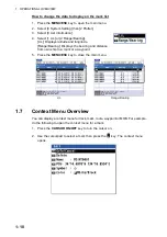
How to change the data to display on the mark list
1. Press the
MENU/ESC
key to open the main menu.
2. Select [8 System Setting] then [2 Plotter].
3. Select [8 List Information].
4. Select [1 L/L] or [2 Range/Bearing].
[L/L]: Displays latitude and longitude.
[Range/Bearing]: Displays the bearing and distance
from own ship to a mark or a waypoint.
5. Press the
MENU/ESC
key to close the main menu.
1.7
Context Menu Overview
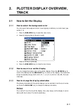
You can display a context menu for track, mark, route, waypoint or MOB. For example,
do the following to open the context menu for a mark.
1. Press the
CURSOR ON/OFF
key to turn the cursor on.
2. Use the cursorpad to select a mark then press the
key. The context menu
opens.
L/L
Range/Bearing


