


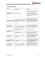


as restaurants, interesting sights, museums and many more besides.
The points of interest on your device are divided up into various categories to make it easier
to search for specific destinations. Additional points of interest can be transferred to the
device via the Falk Online Community (see Chap. 15.6.1).
Coordinates: Positions can be determined precisely with the aid of coordinates. This makes
sense particularly on open terrain away from roads. Coordinates are normally specified with
degrees of latitude and longitude.
Tour
: Tours are the linking together of waypoints, favourite locations or other destinations in
a defined sequence. However, the route between the individual waypoints is not precisely
defined, as as the case with tracks.
Track
: A track is a route which is precisely defined (with the aid of coordinates placed close
to one another which are connected to form a line). This can be displayed on the map so that
you can travel along it. Tracks can also be recorded with the device. In track navigation, no
turn-offs are displayed or spoken announcements issued.
Trackable –
The best-known trackables include the Travel Bugs. These are transported from
one cache to the next and their journey is documented on a special website. In addition, they
have a unique numerical combination for identification.
Trip computer
: The trip computer is the ingenious information and statistics hub in your Falk
LUX. Data relating to the current route but also barometer figures (atmospheric pressure,
altitude) as well as astronomical figures (sunrise and sunset, lunar phase) can be called up.
Waypoint
: A waypoint is a geoposition saved as a pair of coordinates (geographical latitude
and longitude) in open terrain. A waypoint can be any point in the countryside, e.g. a branch
on a path, a hut, or any desired POI (picturesque point in the countryside, viewing point or
interesting sight). Each waypoint can be selected as a destination.
Falk IBEX User Manual
69
Summary of Contents for IBEX
Page 1: ...User Manual ...


