background image

                                                                                                                                          System Overview 


ALPHAAIR 450 USER MANUAL


| 2021-03


P a g e  |  7


3 System Overview 

3.1 

General Introduction


AlphaAir 450 pocket lidar measurement system, the whole device is based on the lightweight 
and high integration design concept, carried on the BB4 or 3rd party UAV like DJI M300, can 
obtain longer endurance. As an emerging means of 3D data acquisition, it can quickly acquire 
terrain  surface  data,  ground  feature,  power  line  information,  etc.,  which  can  realize  high-
precision 3D terrain data and high-density 3D data acquisition of transmission lines. In addition, 
based on the image acquisition by the built-in camera, DOM, DSM, true color point cloud and 
other results can be generated, and road sections, power lines, vegetation and other results 
can be automatically extracted for analysis, and the inspection report can be output.


3.2 

Configuration


List


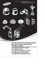
AlphaAir 450 mobile mapping system configuration list is shown below:


  Part Number 


Name


Pcs


System configuration


0102 030 106 

Livox AVIA scan head   

Internal 24 MP camera   

0105 030 123 

Type-C to USB3.1 data copy cable (1 m)   

3204 070 001 

8 Gb USB flash disk (Installation documents and instructions)   

System Components


1903 110 018 

Transport container 

1911 110 017 

Airborne GNSS antenna (TDXL-GGBR7I05)   

8015 020 007 

M300 antenna mount (incl. GPS antenna adapter and feeder)   

8015 020 006 

BB4 installation kit (incl. GPS antenna adapter and feeder, UAV 

platform quick release with shock-absorbing kit)   


Summary of Contents for AlphaAir 450

Page 1: ...Make your work more efficient CHCNAV AlphaAir 450 User Manual Mobile Mapping March 2021...

Page 2: ...troduction 7 3 2 Configuration List 7 3 3 Product Introduction 8 3 4 Product Dimensions 8 3 5 Electrical Characteristics 9 3 6 Airborne Platform 9 3 6 1 Airborne installation steps using Skyport 9 3 6...

Page 3: ...could result in death or serious injury WARNING Indicates a potentially hazardous situation or an unintended use which if not avoided may result in minor or moderate injury NOTICE Indicates a potentia...

Page 4: ...dard prices The customer should provide a stable vehicle roof rack in accordance with the requirements of the technical indicators If the equipment is broken or damaged due to 3rd brand s reason CHCNA...

Page 5: ...are normal Check whether the connecting cables are reliable and stable and whether the GPS cable is stable and normal Check whether the remote controller has sufficient power 2 3 Attentions when Using...

Page 6: ...e read this manual carefully before starting the system All users must follow the safety directions given by the manufacturer and the directions of the person responsible for the product The person re...

Page 7: ...rue color point cloud and other results can be generated and road sections power lines vegetation and other results can be automatically extracted for analysis and the inspection report can be output...

Page 8: ...System Overview ALPHAAIR 450 USER MANUAL 2021 03 P a g e 8 3 3 Product Introduction The product diagrams are shown below 3 4 Product Dimensions Weight 1 0 kg Length width and height are shown below...

Page 9: ...perature 20 C to 50 C Storage temperature 20 C to 65 C Humidity 80 non condensation 3 6 Airborne Platform 3 6 1 Airborne installation steps using Skyport Press the Skyport unlock button to remove the...

Page 10: ...the other end of the GNSS feeder to the GNSS interface of the AA450 3 6 2 Airborne disassemble steps using Skyport Take out the GNSS feeder from the AA450 GNSS interface rotate the GNSS antenna count...

Page 11: ...o check the remaining capacity of Alpha_LAS and Alpha_CAM memory cards If the remaining capacity is less than 10 or does not meet the demand of current collection capacity the data in card should be d...

Page 12: ...ered on successfully Device initialization about two minutes after lidar is powered on the indicator light is normal on which means device initialization successfully completed Start project after suc...

Page 13: ...LiDAR Turn Off ALPHAAIR 450 USER MANUAL 2021 03 P a g e 13 6 LiDAR Turn Off Before turning off equipment please make sure the project is already stopped Long press the ON OFF key to turn off equipment...

Page 14: ...LPHA_LAS the folder is named by the date of collection xxxxxx_I imr IMU data xxxxxx_S TXT synchronizes data xxxxxx_T gps GNSS data xxxxxx_L lv laser data Open ALPHA_CAM the images are stored in DCIM f...

Page 15: ...the project file according to the POS time multiple groups of data can be copied at the same time Click the data into icon and the selected data name will be moved to the right bar Then click copy and...

Page 16: ...ation Generally we need Rinex format If base data is other formats please convert it into Rinex format first For example HCN file ROVER This folder contains GNSS data and IMU data which recorded by Al...

Page 17: ...If still can t power on or power off please contact CHCNAV Support team for repair Equipment can t be timed or need long time Check whether the GPS feeder cable connection is stable Alpha_LAS memory...

Page 18: ...without cutting off the power supply Do not continue using any broken cables Please purchase and replace new cables in time to avoid unnecessary damage Avoid any strong impact or vibration Use an umbr...

Page 19: ...s disassembled or loosen it should be re calibrated When it is difficult to rotate any rotating parts of the equipment please do not forcibly rotate After the equipment is damaged please do not contin...

Page 20: ...R MANUAL 2021 03 P a g e 20 CHC Navigation Building D NO 599 Gaojing Road Qingpu District 201702 Shanghai China Tel 86 21 542 60 273 Fax 86 21 649 50 963 Email sales chcnav com support chcnav com Skyp...

Reviews: